Want more images or videos?
Request additional images or videos from the seller
1 of 5
Auction endedBrowse Current Auctions
Large Original Antique Map of Oklahoma, USA, 1894
Price:$185
$195List Price
About the Item
- Creator:Rand McNally Co. (Maker)
- Dimensions:Height: 13.5 in (34.29 cm)Width: 20.5 in (52.07 cm)Depth: 0.07 in (1.78 mm)
- Materials and Techniques:Paper,Other
- Place of Origin:
- Period:
- Date of Manufacture:1894
- Condition:Wear consistent with age and use.
- Seller Location:St Annes, GB
- Reference Number:1stDibs: LU1836330109422
About the Seller
4.9
Gold Seller
Premium sellers maintaining a 4.3+ rating and 24-hour response times
1stDibs seller since 2016
3,281 sales on 1stDibs
Typical response time: 1 hour
Associations
International Confederation of Art and Antique Dealers
Associations
Authenticity Guarantee
In the unlikely event there’s an issue with an item’s authenticity, contact us within 1 year for a full refund. DetailsMoney-Back Guarantee
If your item is not as described, is damaged in transit, or does not arrive, contact us within 7 days for a full refund. Details24-Hour Cancellation
You have a 24-hour grace period in which to reconsider your purchase, with no questions asked.Vetted Professional Sellers
Our world-class sellers must adhere to strict standards for service and quality, maintaining the integrity of our listings.Price-Match Guarantee
If you find that a seller listed the same item for a lower price elsewhere, we’ll match it.Trusted Global Delivery
Our best-in-class carrier network provides specialized shipping options worldwide, including custom delivery.You May Also Like
Original Engraved Antique Map of the World, Colorful and Decorative, C.1780
By Pierre François Tardieu
Located in Langweer, NL
Antique map titled 'Mappemonde en Deux Hemispheres ou l'on a Indique les Nouvelles Decouvertes' - This handsome double hemisphere map presents a ...
Category
Antique 18th Century Maps
Materials
Paper

$446 Sale Price
20% Off
H 15.6 in W 20.32 in D 0 in
Very Decorative Original Antique Map of the World, Published in France in c.1780
By Rigobert Bonne
Located in Langweer, NL
Antique map titled 'L'Ancien Monde Et Le Nouveau en Deux Hemispheres' - Double hemisphere map of the World, showing the contemporary geographical...
Category
Antique 18th Century French Maps
Materials
Paper

$548 Sale Price
40% Off
H 10.24 in W 17.6 in D 0 in
Antique Map of Korea by Kozaki, 1903
Located in Langweer, NL
Old map of Korea by S. Kozaki. Restored and mounted.
Category
20th Century Maps
Materials
Paper

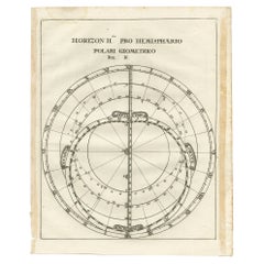
Antique Map of a Hemisphere by Scherer, c.1703
Located in Langweer, NL
Antique map depiciting a horizon/hemisphere. Printed for Scherer's 'Atlas Novus' (1702-1710).
Artists and Engravers: Heinrich Scherer (1628-1704) was a Professor of Hebrew, Mathematics and Ethics at the University of Dillingen until about 1680. Thereafter he obtained important positions as Official Tutor to the Royal Princes...
Category
Antique 18th Century Maps
Materials
Paper
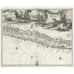
Antique Map of Chili by Montanus, circa 1671
By Arnoldus Montanus
Located in Langweer, NL
Antique map titled 'Chili'. A very attractive map covering the known coastal region of Chile. The Andes are shown prominently, with two live volcanoes in the vicinity of Villarrica. ...
Category
Antique Mid-17th Century Maps
Materials
Paper
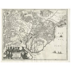
Antique Map of Paraguay by A. Montanus, circa 1671
By Arnoldus Montanus
Located in Langweer, NL
Antique map titled 'Paraquaria Vulgo Paraguay Cum adjacentibus'. Antique map extending from Rio de Janiero to the Rio de la Plata basin. The map include...
Category
Antique Mid-17th Century Maps
Materials
Paper
Antique Map of Guadelupe in the Caribbean, 1759
By Jacques-Nicolas Bellin
Located in Langweer, NL
Antique map titled 'Carte De L'Isle De La Guadeloupe'. Detailed map of Guadalupe, Mari-Galante and the Isles de Saintes. Produced by Nichlas Bellin for Prevost d'Exiles influential t...
Category
Antique Mid-18th Century French Maps
Materials
Paper

Antique Map of Asia by Dufour, circa 1834
Located in Langweer, NL
Antique map titled 'Asie par A.H. Dufour'. Uncommon map of Asia. Published by or after A.H. Dufour, circa 1834. Source unknown, to be determined.
Category
Antique Mid-19th Century Maps
Materials
Paper

Antique Map of Africa by Dufour, circa 1834
Located in Langweer, NL
Antique map titled 'Afrique'. Uncommon map of Africa. Published by or after A.H. Dufour, circa 1834. Source unknown, to be determined.
Category
Antique Mid-19th Century Maps
Materials
Paper

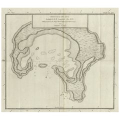
Antique Map of Christmas Island by Cook, C.1781
Located in Langweer, NL
Antique map Kiribati titled 'Christmas Island (..)'. Antique map of Christmas Island, also known as Kiritimati. Originates from an edition of Cook's Voyages.
Artists and Engravers: Engraved by Duff.
Condition: Good, some wear and age-related toning. Please study image carefully.
Date: c.1781
Overall size: 27.5 x 21.5 cm.
Image size: 20.5 x 18 cm.
We sell original antique maps to collectors, historians, educators and interior decorators all over the world. Our collection includes a wide range of authentic antique maps...
Category
Antique 18th Century British Maps
Materials
Paper
More From This Seller
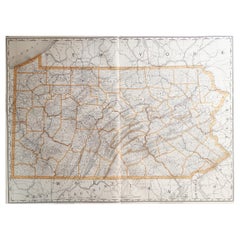
View AllLarge Original Antique Map of Pennsylvania, USA, 1894
By Rand McNally
Co.
Located in St Annes, Lancashire
Fabulous map of Pennsylvania
Original color.
By Rand, McNally & Co.
Published, 1894.
Unframed.
Free shipping.
Category
Antique 1890s American Maps
Materials
Paper
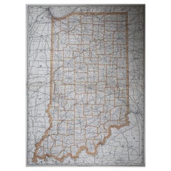
Large Original Antique Map of Indiana, USA, 1894
By Rand McNally
Co.
Located in St Annes, Lancashire
Fabulous map of Indiana.
Original color.
By Rand, McNally & Co.
Published, 1894.
Unframed.
Free shipping.
Category
Antique 1890s American Maps
Materials
Paper
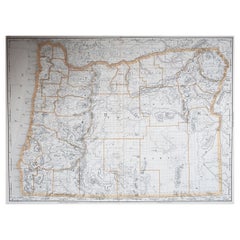
Large Original Antique Map of Oregon, USA, 1894
By Rand McNally
Co.
Located in St Annes, Lancashire
Fabulous map of Oregon.
Original color.
By Rand, McNally & Co.
Published, 1894.
Unframed.
Free shipping.
Category
Antique 1890s American Maps
Materials
Paper
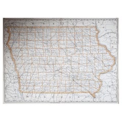
Large Original Antique Map of Iowa, USA, 1894
By Rand McNally
Co.
Located in St Annes, Lancashire
Fabulous map of Iowa.
Original color.
By Rand, McNally & Co.
Published, 1894.
Unframed.
Free shipping.
Category
Antique 1890s American Maps
Materials
Paper
Large Original Antique Map of Utah, USA, 1894
By Rand McNally
Co.
Located in St Annes, Lancashire
Fabulous map of Utah
Original color
By Rand, McNally & Co.
Published, 1894
Unframed
Free shipping.
Category
Antique 1890s American Maps
Materials
Paper

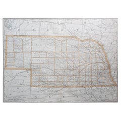
Large Original Antique Map of Nebraska, USA, 1894
By Rand McNally
Co.
Located in St Annes, Lancashire
Fabulous map of Nebraska
Original color
By Rand, McNally & Co.
Published, 1894
Unframed
Some slight restoration to the Gosper / Furnas area. Seen in the last image
Free shipping.
Category
Antique 1890s American Maps
Materials
Paper
Still Thinking About These?
All Recently ViewedMore Ways To Browse
Antique Furniture Oklahoma
Tunisia Antique Map
Used Office Furniture Rhode Island
Antique Chesapeake Bay Map
Antique Copper Australia
Antique Furniture Pondicherry
Antique Map Of Cornwall
Antique Maps Dublin
Antique Maps Of Malta
Antique Saudi Arabia
Armenia Map
Cambodia Antique Map
Coronelli Globe
Denoyer Geppert Anatomy
E Fletcher
Framed Africa Maps
Gabon Antique Map
Hudson River Map