Items Similar to Large U.S. Coast and Geodetic Survey Chart A of the Atlantic Coast, 1877


Want more images or videos?
Request additional images or videos from the seller
1 of 9
Large U.S. Coast and Geodetic Survey Chart A of the Atlantic Coast, 1877
$4,800
£3,626.63
€4,155.02
CA$6,697.56
A$7,299.99
CHF 3,859.44
MX$87,878.08
NOK 48,985.95
SEK 44,910.10
DKK 31,038.19
About the Item
Large U.S. Coast and Geodetic Survey Chart A of the Atlantic Coast, 1877, re-issued in February 1881, a printed paper laid down on linen navigational chart of the U.S. Atlantic coast line from Cape Sable to Cape Hatteras with depth soundings and coastal features, and including enlarged insets of Boston Harbor, Portland Harbor, Delaware Bay, New York Entrance, and Chesapeake Bay. The location of lighthouses has been highlighted on the chart.
In surprisingly good condition for a used onboard navigational chart, with only minimal wear here and there along edges.
Measures: 50-5/8 in H x 37-5/8 in W
Framed: 54-3/4 in H x 41-3/4 in W
- Dimensions:Height: 54.75 in (139.07 cm)Width: 41.75 in (106.05 cm)Depth: 1 in (2.54 cm)
- Style:Other (Of the Period)
- Materials and Techniques:Linen,Other
- Place of Origin:
- Period:
- Date of Manufacture:1887
- Condition:Wear consistent with age and use.
- Seller Location:Nantucket, MA
- Reference Number:Seller: AD - 292-23 RHE1stDibs: LU903944677652
About the Seller
5.0
Gold Seller
Premium sellers maintaining a 4.3+ rating and 24-hour response times
1stDibs seller since 2010
280 sales on 1stDibs
Typical response time: 2 hours
- ShippingRetrieving quote...Shipping from: Nantucket, MA
- Return Policy
More From This Seller
View All19th Century Chart of New England Coast, 1847
By U.S. Government
Located in Nantucket, MA
19th Century Chart of New England Coast: the U.S. Coast Survey Sketch A - Section 1, a triangulation chart showing the progress of the survey and details along the New England coas...
Category
Antique 1840s American Other Maps
Materials
Paper

DesBarres (1776) Chart of Nantucket Island, 1966 Restrike
Located in Nantucket, MA
DesBarres (1776) Chart of Nantucket Island and the Eastern Half of Martha's Vineyard Restrike, published by the Massachusetts Historical Society in association with Haley
Steel...
Category
Vintage 1960s American Other Maps
Materials
Paper
Nantucket High-Ways, By-Ways and Not-Ways Decorative Map by Tony Sarg, ca 1930
By Tony Sarg
Located in Nantucket, MA
Vintage Nantucket High-Ways, By-Ways and Not-Ways Decorative Map by Tony Sarg, (Nantucket: 1880 - 1942) circa 1930, a decorative tourist map of Nantucket Island with details of roadw...
Category
Vintage 1930s American Other Maps
Materials
Paper

18th Century Hand Colored Map of The State of Massachusetts, 1796
Located in Nantucket, MA
18th Century Hand Colored Map of "The State of Massachusetts from the best information," 1796, by cartographer and illustrator John Reid published in his "American Atlas," a period e...
Category
Antique 1790s American American Colonial Maps
Materials
Paper

Hand Colored Map of Nantucket by Austin Strong (1881 - 1952), circa 1921
Located in Nantucket, MA
Map of Nantucket by Austin Strong (1881 - 1952), circa 1921, an original print on paper whimsical map of Nantucket Island by Robert Louis Stevenson's step- grandson, noted stage set ...
Category
Vintage 1920s American Folk Art Maps
Materials
Paper
Tony Sarg Map of Nantucket Town, 1937
By Tony Sarg
Located in Nantucket, MA
Tony Sarg Map of Residential Main Street, Nantucket, 1937, a black and white printed map of our historic downtown area, with images of each building, street names and whimsical figur...
Category
Vintage 1930s American Other Maps
Materials
Paper

You May Also Like
Antique Maritime Chart of East Coast Virginia to Nova Scotia
Located in Norwell, MA
1920 nautical chart of the East Coast of the United States from Virginia to Maine, New Brunswick, and Nova Scotia. The chart shows Cape Cod, Long Island, the Connecticut coast, Jersey Shore, Maine, New Hampshire, etc. Very detailed, showing ports, lighthouses, shoals, depths, etc. The chart is by famous cartographer George W. Eldridge, compiled from surveys of the United States government, British Admiralty, George Eldridge, and others. First authorized by George Eldridge, published in 1916 by Wilfred O. White with a merchant's stamp of Charles Hutchinson...
Category
Vintage 1920s North American Maps
Materials
Paper

Long Island Chart from 1828
Located in Norwell, MA
Rare original chart of Long Island Sound by E + G Blunt of New York, 179 Water St. "Surveyed in the years 1828, 29 & 30" Exceedingly rare and early chart, titled Long Island Sound fr...
Category
Antique 1830s Nautical Objects
Materials
Paper

Old Map of Cook
s Discovery and Charting of the East Coast of Australia, 1803
Located in Langweer, NL
Antique map titled 'Kaart van Nieuw Zuid Wales of de Oostlyke Kust van Nieuw Holland ontdekt en onderzogt door den Luitenant J. Cook met het Schip de Endeavour in het Jaar 1770'.
...
Category
Antique Early 1800s Maps
Materials
Paper

1898 Chart of Boston Bay
Located in Norwell, MA
Original 1898 chart showing Massachusetts Bay with the coast from Cape Ann to Cape Cod. This is a U.S. Navy Geodetic survey chart. All towns are noted along the coast. Framed with gl...
Category
Antique 1890s Nautical Objects
Materials
Paper

$1,495
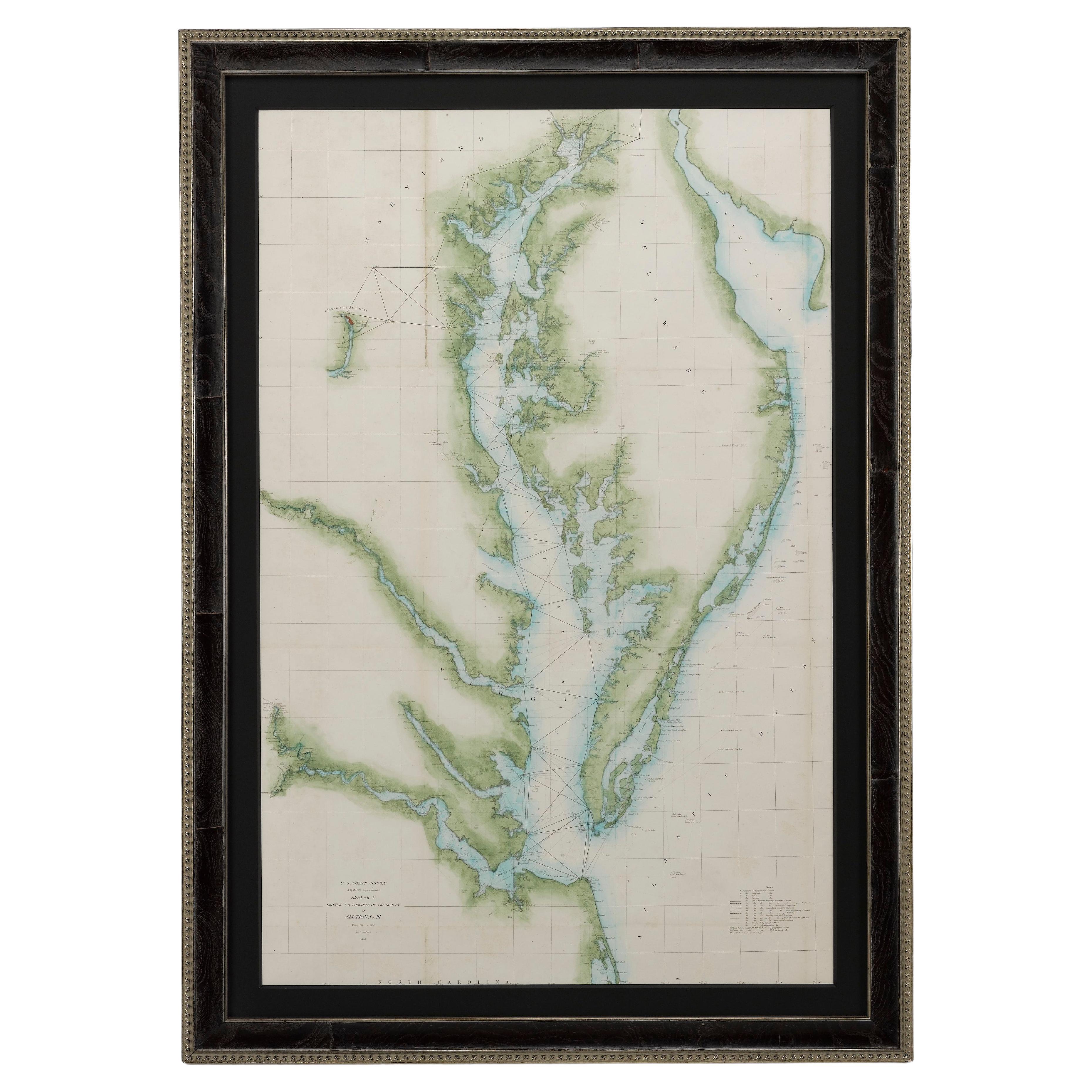
1856 U.S. Coast Survey Map of Chesapeake Bay and Delaware Bay
Located in Colorado Springs, CO
Presented is U.S. Coast Survey nautical chart or maritime map of Chesapeake Bay and Delaware Bay from 1856. The map depicts the region from Susquehanna, Maryland to the northern Outer Banks in North Carolina. It also shows from Richmond and Petersburg, Virginia to the Atlantic Ocean. The map is highly detailed with many cities and towns labeled throughout. Rivers, inlets, and bays are also labeled. Various charts illustrating more specific parts of the region are marked on the map using dotted lines. The lines form boxes, and the corresponding chart number and publication date are given. Extensive triangulation surveys were conducted the length of Chesapeake Bay and are illustrated here. Hampton Roads, Virginia is labeled, along with the James, York, and Rappahannock Rivers, which were all extensively surveyed.
The chart was published under the supervision of A. D. Bache, one of the most influential and prolific figures in the early history of the U.S. Coast Survey, for the 1856 Report of the Superintendent of the U.S. Coast Survey. Alexander Dallas Bache (1806-1867) was an American physicist, scientist, and surveyor. Bache served as the Superintendent of the U.S. Coast Survey from 1843 to 1865. Born in Philadelphia, Bache toured Europe and composed an important treatise on European Education. He also served as president of Philadelphia's Central High School and was a professor of natural history and chemistry at the University of Pennsylvania. Upon the death of Ferdinand Rudolph Hassler, Bache was appointed Superintendent of the United States Coast Survey.
The Office of the Coast Survey, founded in 1807 by President Thomas Jefferson and Secretary of Commerce Albert Gallatin...
Category
Antique 1850s American Maps
Materials
Paper

Original Imray
Son Chart of North Atlantic, 1876
Located in Norwell, MA
Nautical chart of the North Atlantic showing the Eastern United States coast, Caribbean Islands, South America (Venezuela and ), British Possessions (Canada - Gulf of Lawrence, Newfo...
Category
Antique 1870s Nautical Objects
Materials
Paper

More Ways To Browse
Antique Delaware
Lighthouse Antique
Round Table Base
Cream Soup
Early English Silver
James Bond
Paisley Rugs and Carpets
Antique Pagoda
Black And Chrome Lounge Chair
Ceramic 1960s Italy
Vintage 1930 Dining Room Set
Antique Brass And Copper
Antique Cow
Antique Harvest
Antique Victorian Dining Tables
Environment Furniture
Italian Plastic Chairs
Made In Belgium