Items Similar to Málaga 1901: A Cartographic Detailing of Andalusia
s Coastal Jewel

Want more images or videos?
Request additional images or videos from the seller
1 of 8
Málaga 1901: A Cartographic Detailing of Andalusia
s Coastal Jewel
$325.63
$407.0420% Off
£243.52
£304.4020% Off
€272
€34020% Off
CA$448.70
CA$560.8820% Off
A$489.52
A$611.9120% Off
CHF 259.20
CHF 32420% Off
MX$5,865.89
MX$7,332.3720% Off
NOK 3,301.06
NOK 4,126.3220% Off
SEK 3,018.57
SEK 3,773.2120% Off
DKK 2,071.60
DKK 2,589.5020% Off
About the Item
The map depicts the province of Málaga, located in the autonomous community of Andalusia in southern Spain, as it was in 1901. Here are the key features illustrated on the map:
- **Topography**: The map highlights the mountainous regions of Málaga, including parts of the Montes de Málaga and the nearby Sierras, which are indicative of the province’s rugged terrain.
- **Coastline**: The province's extensive Mediterranean coastline is prominently shown, which includes the famous Costa del Sol.
- **Hydrography**: Blue lines represent rivers and water bodies, likely including the Guadalhorce river, which is one of the main rivers in the province.
- **Transportation**: Red lines signify the roads and railways, showing the connections within Málaga and to other regions.
- **Urban Centers**: Various symbols and labels denote the locations of cities, towns, and villages, with the capital, also named Málaga, marked as a significant urban center.
- **Political Boundaries**: Dotted lines may delineate the administrative boundaries within the province.
- **Legend**: The map contains a legend (Signos Convencionales) that explains the symbols used for provincial capitals, roads, railways, and other key landmarks.
- **Scale**: A scale in kilometers at the bottom of the map provides a reference for distance measurements.
- **Coat of Arms**: The coat of arms of Málaga, featuring the castle and the lion, is prominently displayed, symbolizing the province's historical and heraldic identity.
About the province of Málaga:
Málaga is known for its rich cultural history, being the birthplace of Pablo Picasso, and for its vibrant art scene, exemplified by numerous galleries and the famous Picasso Museum. The economy of Málaga is significantly supported by tourism, with millions of visitors drawn to its sunny beaches, resorts, and historical landmarks each year. The city of Málaga is also a major port and commercial hub on the Mediterranean. Apart from tourism, the province's agricultural sector is known for producing olives, almonds, and especially sweet wines. Málaga’s cuisine features seafood and local produce, with dishes like 'espetos' (sardines on a skewer) and 'gazpachuelo malagueño' (a mayonnaise-based fish soup).
- Dimensions:Height: 14.77 in (37.5 cm)Width: 20.08 in (51 cm)Depth: 0 in (0.02 mm)
- Materials and Techniques:
- Period:1900-1909
- Date of Manufacture:1901
- Condition:Good condition. Central vertical folding lines as issued. Aged paper with typically warm, yellowish-brown hue, especially around the edges. Check the images carefully.
- Seller Location:Langweer, NL
- Reference Number:Seller: BG-13642-281stDibs: LU3054338032232
About the Seller
5.0
Recognized Seller
These prestigious sellers are industry leaders and represent the highest echelon for item quality and design.
Platinum Seller
Premium sellers with a 4.7+ rating and 24-hour response times
Established in 2009
1stDibs seller since 2017
2,792 sales on 1stDibs
Typical response time: <1 hour
- ShippingRetrieving quote...Shipping from: Langweer, Netherlands
- Return Policy
More From This Seller
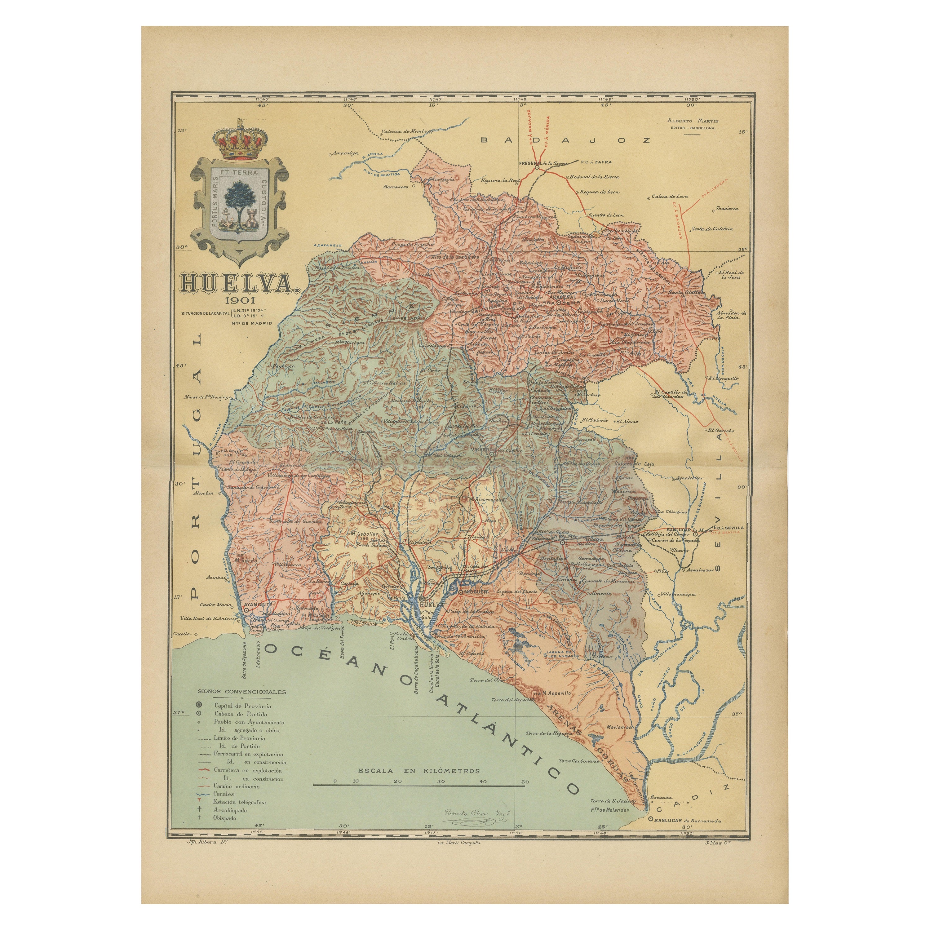
View AllHuelva 1901: A Cartographic Presentation of Andalusia
s Atlantic Frontier
Located in Langweer, NL
The map displays the province of Huelva, located in the southwestern part of the autonomous community of Andalusia in Spain, as of the year 1901. It outlines various geographic and m...
Category
Antique Early 1900s Maps
Materials
Paper

$344 Sale Price
20% Off
Free Shipping
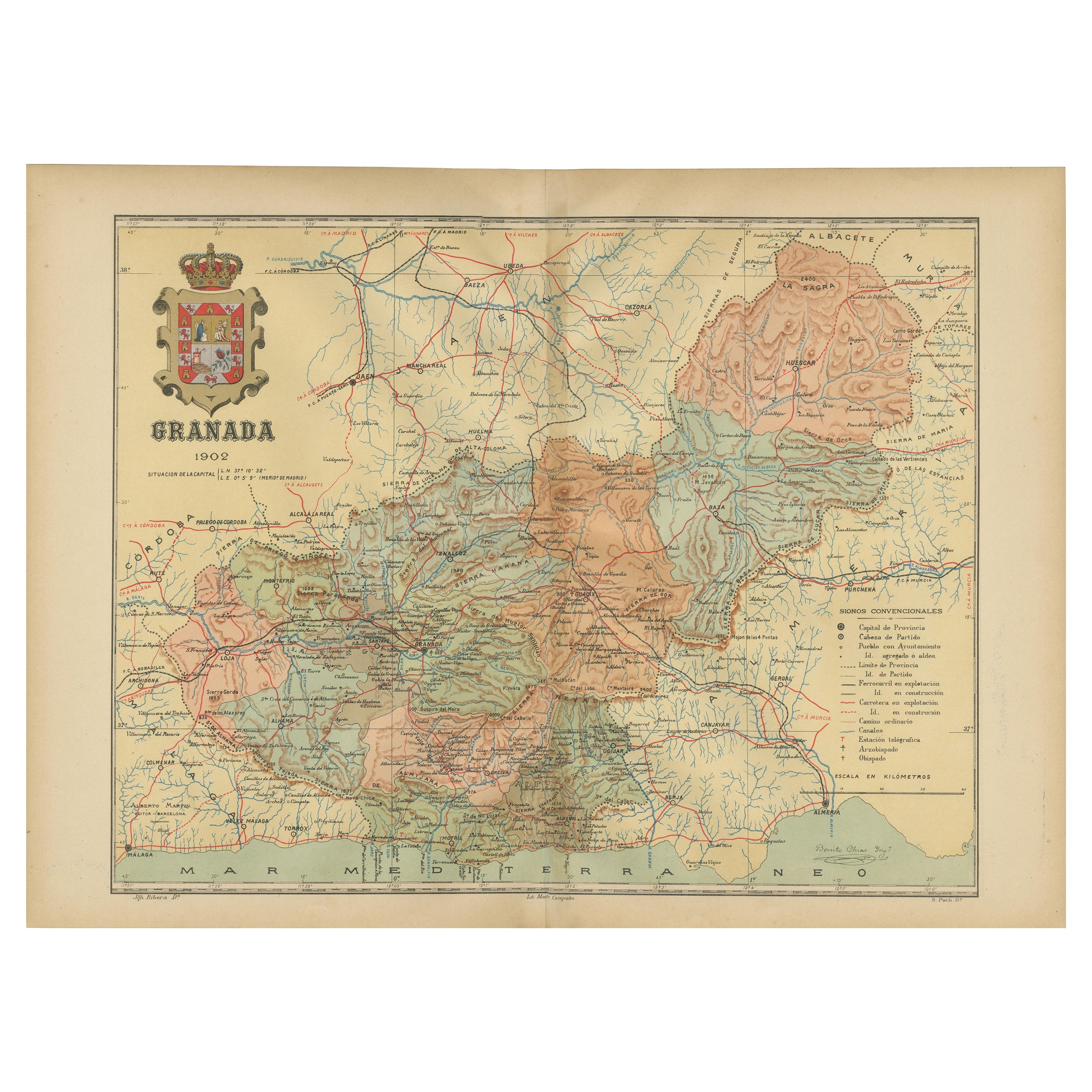
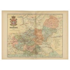
Granada 1902: A Cartographic Exploration of Andalusia
s Mountainous Province
Located in Langweer, NL
This original antique map depicts the province of Granada, part of the autonomous community of Andalusia in southern Spain, as of 1902. The map features several important details:
I...
Category
Antique Early 1900s Maps
Materials
Paper
$373 Sale Price
20% Off
Free Shipping
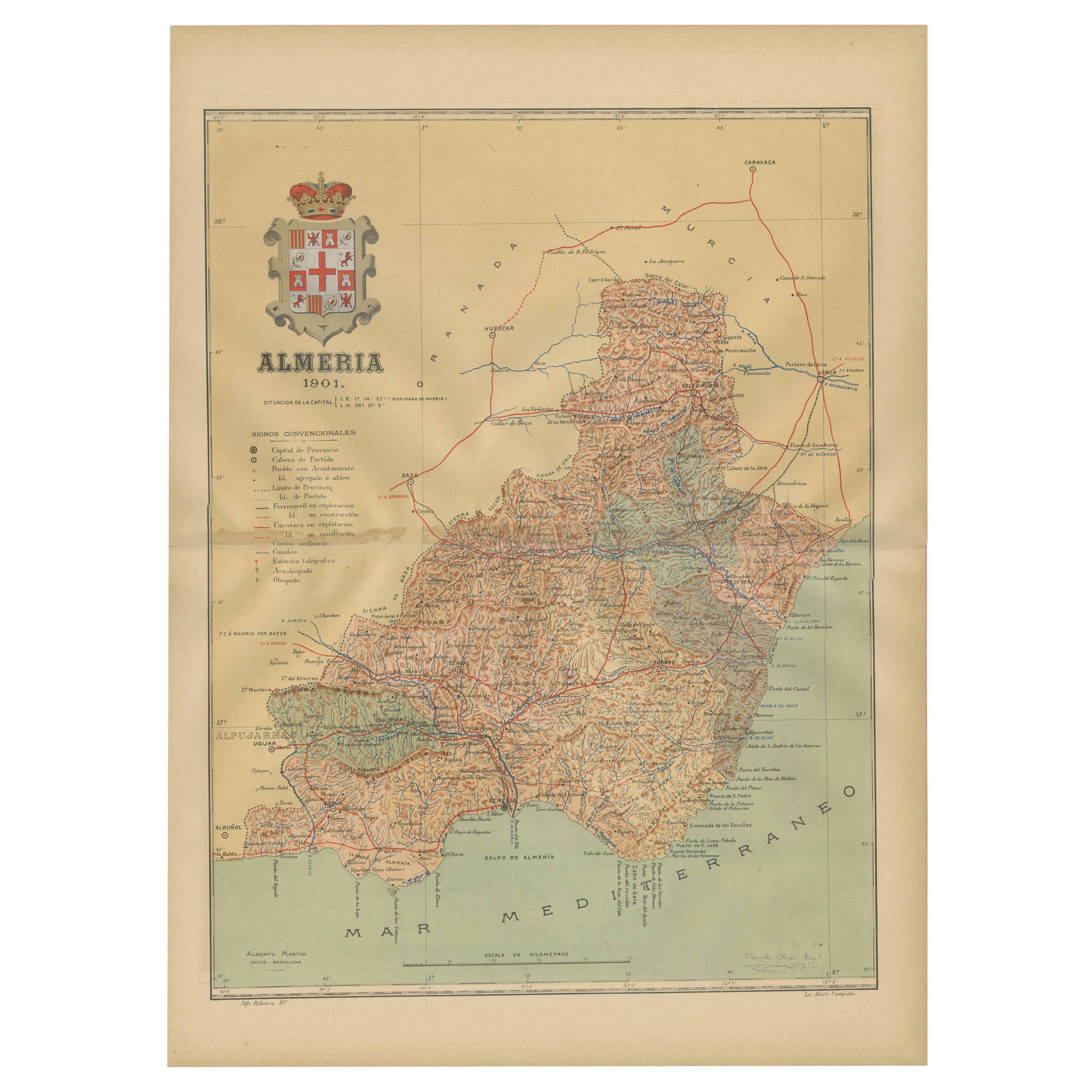
Almería 1901: Coastal Contours and Landscapes in a Map of Southeastern Spain
Located in Langweer, NL
An original antique map of the province of Almería, Spain, from the year 1901.
The Mediterranean Sea, labeled as "Mar Mediterraneo," forms the southeastern boundary of the province...
Category
Antique Early 1900s Maps
Materials
Paper

$306 Sale Price
20% Off
Free Shipping
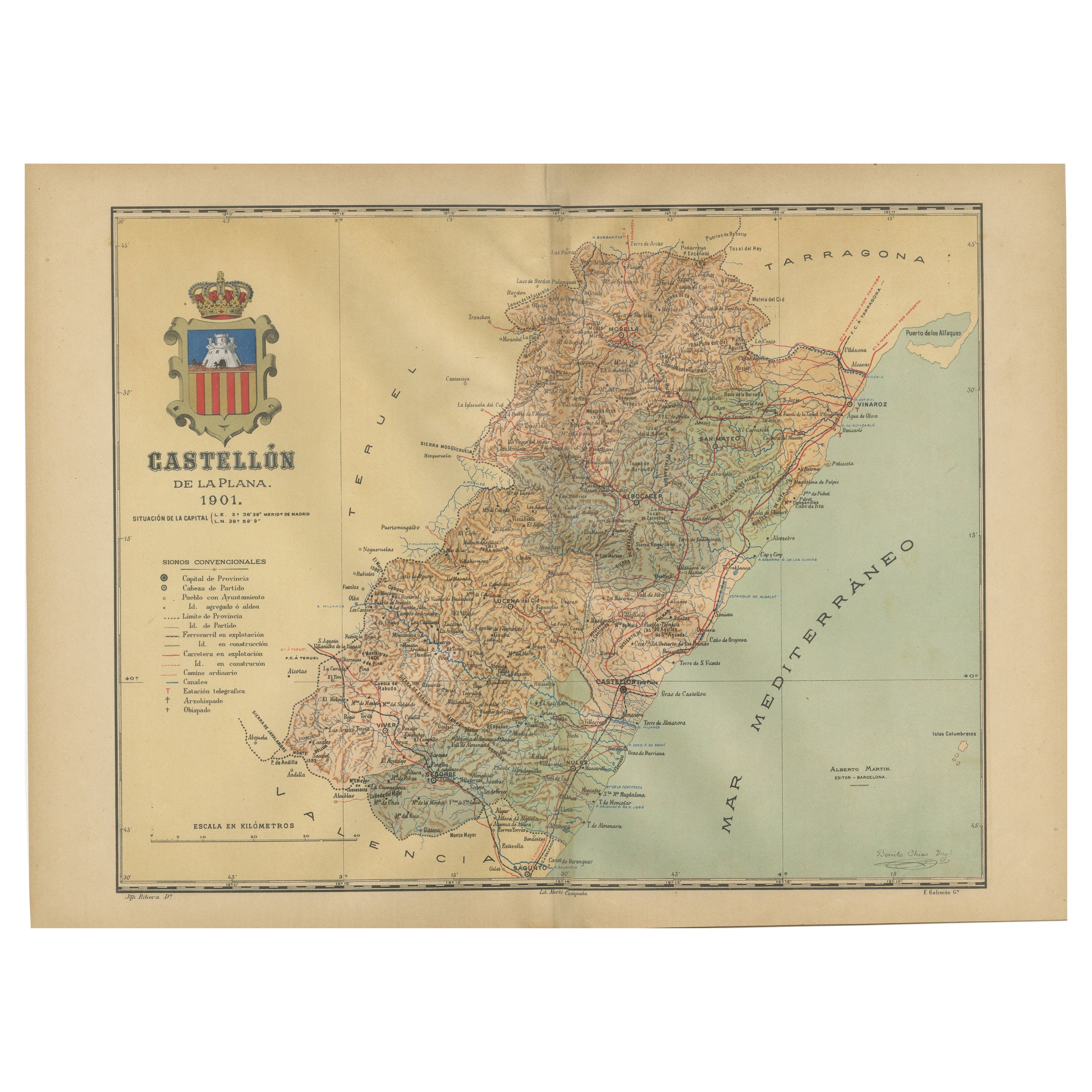
Castellón de la Plana 1901: A Cartographic Perspective of the Valencian Coast
Located in Langweer, NL
The authentic map depicts the province of Castellón de la Plana, often referred to simply as Castellón, situated in the eastern part of Spain in the Valencian Community, and the map ...
Category
Antique Early 1900s Maps
Materials
Paper

$402 Sale Price
20% Off
Free Shipping
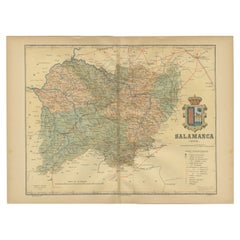
1902 Cartographic View of Salamanca: The Golden Province of Spain
Located in Langweer, NL
This map showcases the province of Salamanca in the year 1902. Salamanca is located in the autonomous community of Castile and León in western Spain. It is bordered by the provinces ...
Category
Antique Early 1900s Maps
Materials
Paper
$264 Sale Price
35% Off
Free Shipping
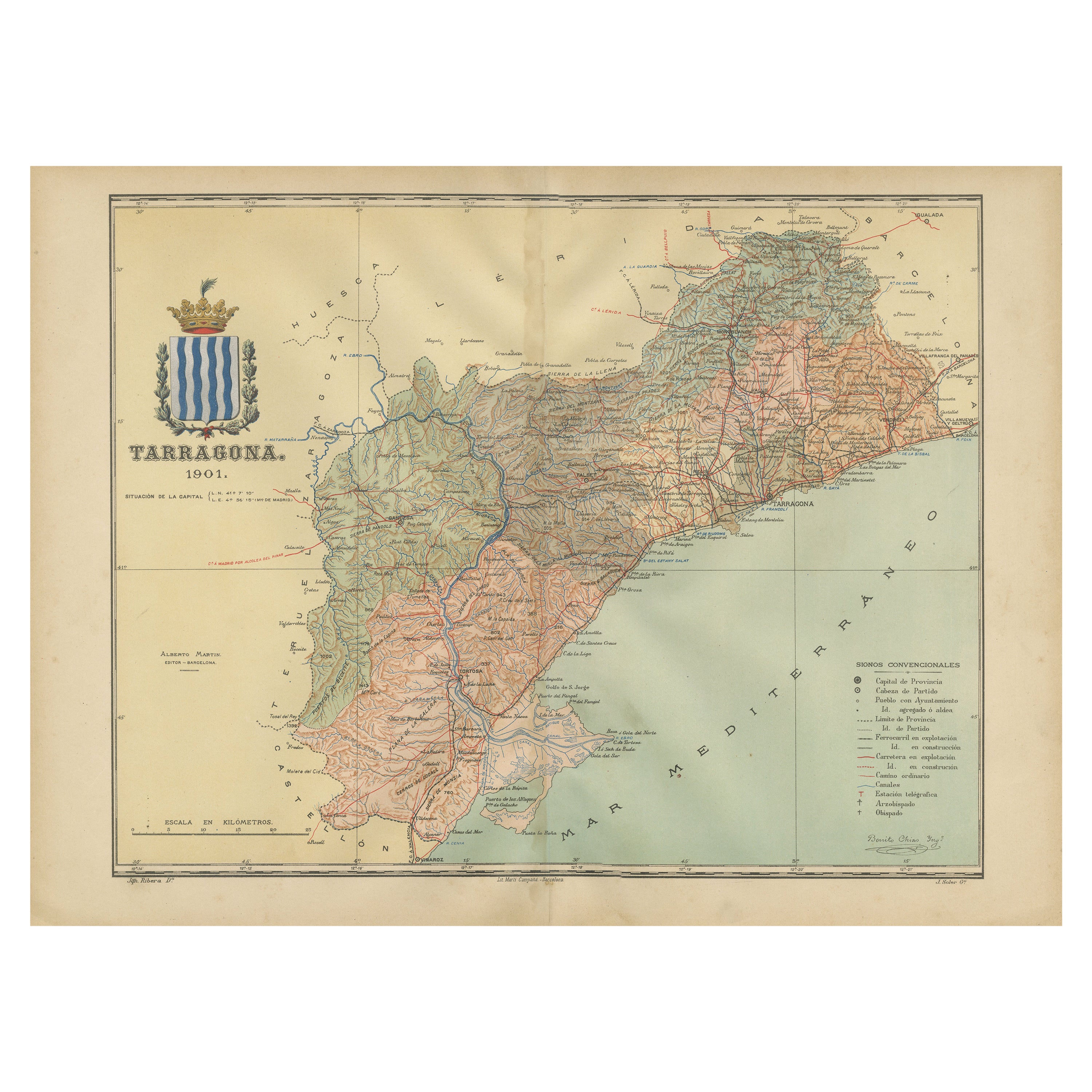
A Catalonian Cartographic Depiction of Tarragona Province, 1901
Located in Langweer, NL
This image depicts a historical map of the province of Tarragona, which is in the northeastern part of Spain, within the autonomous community of Catalonia. The map is dated 1901, sug...
Category
Antique Early 1900s Spanish Maps
Materials
Paper

You May Also Like
Large Original Antique Map of Madeira. 1894
Located in St Annes, Lancashire
Superb Antique map of Madeira
Published Edward Stanford, Charing Cross, London 1894
Original colour
Good condition
Unframed.
Free shipping
Category
Antique 1890s English Maps
Materials
Paper

Large Original Vintage Map of Spain, circa 1920
Located in St Annes, Lancashire
Great map of Spain
Original color.
Good condition
Published by Alexander Gross
Unframed.
Category
Vintage 1920s English Maps
Materials
Paper

Large Original Antique Map of The Canary Islands. 1894
Located in St Annes, Lancashire
Superb Antique map of The Canary Islands
Published Edward Stanford, Charing Cross, London 1894
Original colour
Good condition
Unframed.
Free shipping
Category
Antique 1890s English Maps
Materials
Paper

Large Original Antique Map of Cyprus. 1894
Located in St Annes, Lancashire
Superb Antique map of Cyprus
Published Edward Stanford, Charing Cross, London 1894
Original colour
Good condition
Unframed.
Free shipping
Category
Antique 1890s English Maps
Materials
Paper

Geographical Antique Map of Principality of Monaco
By Bruno Santini
Located in Alessandria, Piemonte
ST/609 - Interesting antique color map of Monaco Principality in French language : "Carte qui contient le Principauté de Piémont, le Monferrat et la comté de...
Category
Antique Late 18th Century Italian Other Maps
Materials
Paper

Antique Map of Principality of Monaco
By Antonio Vallardi Editore
Located in Alessandria, Piemonte
ST/619 - "Old Geographical Atlas of Italy - Topographic map of ex-Principality of Monaco" -
ediz Vallardi - Milano -
A somewhat special edition ---
Category
Antique Late 19th Century Italian Other Prints
Materials
Paper

More Ways To Browse
Antique Skewers
Antique Sultanabad Carpets
Used Beige Sofa
Antique Plate Germany
Hand Tufted Rugs
Rare China
Side Table Made In Denmark
Thonet Antique
Victorian Hall Tables
Vintage Computer
England Antique Plates
19th Century Round Dining Table
Antique Counters
Antique Thrones
Carved Chinese Tables
Italian Ceramic 1960s
Mid Century Modern Danish Teak Dining Tables
Rosenthal Century