Items Similar to Map of Aveyron France with Rodez, Millau and Wine Routes, 19th Century


Want more images or videos?
Request additional images or videos from the seller
1 of 10
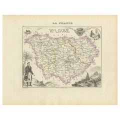
Map of Aveyron France with Rodez, Millau and Wine Routes, 19th Century
$143.60
£107.25
€120
CA$197.83
A$215.60
CHF 114.17
MX$2,589.60
NOK 1,445.42
SEK 1,328.92
DKK 914.19
About the Item
Map of Aveyron France with Rodez, Millau and Wine Routes, 19th Century
Description:
This detailed and decorative 19th-century map of Aveyron, a department in southern France, was drawn by Alexandre Vuillemin and published by Migeon in Paris as part of the *Nouvel Atlas Illustré*. It blends accurate geographic detail with beautifully engraved illustrations and hand-colored borders, presenting a rich visual profile of this historic and agricultural region.
The map shows all major towns and roads within Aveyron, including Rodez, Villefranche-de-Rouergue, Espalion, and Millau. Department borders are hand-colored in soft yellow, while rivers and road networks are intricately engraved. In the top left corner is a view of Millau, long before its modern fame for the Millau Viaduct. At bottom left, a larger vignette depicts Rodez, the prefecture of the department, with its striking cathedral visible on the skyline and a rural scene of daily life in the foreground.
On the right side of the map is a figure of Admiral d’Estaing, a native of Aveyron and a prominent figure during the American Revolutionary War. The coat of arms and a vulture engraved below pay tribute to the region’s natural identity, particularly referencing the Grands Causses and the gorges where birds of prey nest. These flourishes reflect the region’s harmony between history, geography, and nature.
Aveyron is also known for its agricultural traditions, including wine production in the Marcillac region. The wines of Aveyron are lesser known but full of character, made from grapes such as Fer Servadou (locally called Mansois). Marcillac’s red and rosé wines are noted for their earthy, slightly spicy notes, grown in terraced vineyards on iron-rich soils. The region is also famous for Roquefort cheese and rustic gastronomy, making this map appealing for collectors of culinary or wine-related heritage.
Alexandre Vuillemin’s maps are admired for their balance of scientific detail and visual charm. Migeon’s publication enriched the atlas with cultural references, decorative flourishes, and educational value, making these prints both artistic and informative.
Condition summary:
Very good antique condition with light age toning and a few small foxing spots in the margins. The engraved detail is crisp, and the original hand coloring is clean and intact.
Framing tips:
Best presented in a dark oak or classic black frame with a warm cream or ivory mat to highlight the yellow borders. UV-protective glass is recommended to preserve the integrity of the paper and detail over time.
- Dimensions:Height: 10.28 in (26.1 cm)Width: 12.8 in (32.5 cm)Depth: 0.01 in (0.2 mm)
- Materials and Techniques:Paper,Engraved
- Place of Origin:
- Period:
- Date of Manufacture:circa 1850
- Condition:Very good antique condition with light age toning and a few small foxing spots in the margins. The engraved detail is crisp, and the original hand coloring is clean and intact.
- Seller Location:Langweer, NL
- Reference Number:Seller: BG-13331-111stDibs: LU3054345359662
About the Seller
5.0
Recognized Seller
These prestigious sellers are industry leaders and represent the highest echelon for item quality and design.
Platinum Seller
Premium sellers with a 4.7+ rating and 24-hour response times
Established in 2009
1stDibs seller since 2017
2,788 sales on 1stDibs
Typical response time: <1 hour
- ShippingRetrieving quote...Shipping from: Langweer, Netherlands
- Return Policy
More From This Seller
View AllMap of Ardèche France with Annonay and Vineyards by Vuillemin, 19th c
Located in Langweer, NL
Map of Ardèche France with Annonay and Vineyards by Vuillemin, 19th c
This beautifully engraved 19th-century map of Ardèche, a department in southeastern France, comes from Alexandr...
Category
Antique Mid-19th Century French Maps
Materials
Paper

Map of Allier France with Saint-Pourçain Wine Region by Vuillemin, 19th c
Located in Langweer, NL
Map of Allier France with Saint-Pourçain Wine Region by Vuillemin, 19th c
This decorative 19th-century map of Allier, a central department of France, comes from the celebrated Nouve...
Category
Antique Mid-19th Century French Maps
Materials
Paper

Map of Côte-d
Or France with Dijon and Burgundy Wine Region, 19th Century
Located in Langweer, NL
Map of Côte-d'Or France with Dijon and Burgundy Wine Region, 19th Century
Description:
This beautifully engraved 19th-century map of Côte-d'Or, located in the historic region of Bur...
Category
Antique Mid-19th Century French Maps
Materials
Paper

Map of Loire France with Saint-Étienne and Montbrison by Vuillemin, 19th c
Located in Langweer, NL
Map of Loire France with Saint-Étienne and Montbrison by Vuillemin, 19th c
This beautifully engraved and hand-colored map of the department of Loire in east-central France is from t...
Category
Antique Mid-19th Century French Maps
Materials
Paper

Map of Aube France with Troyes and Champagne Wine Region, 19th Century
Located in Langweer, NL
Map of Aube France with Troyes and Champagne Vineyards by Vuillemin, 19th c
Description:
This 19th-century map of the Aube department in the Grand Est region of northeastern France ...
Category
Antique Mid-19th Century French Maps
Materials
Paper

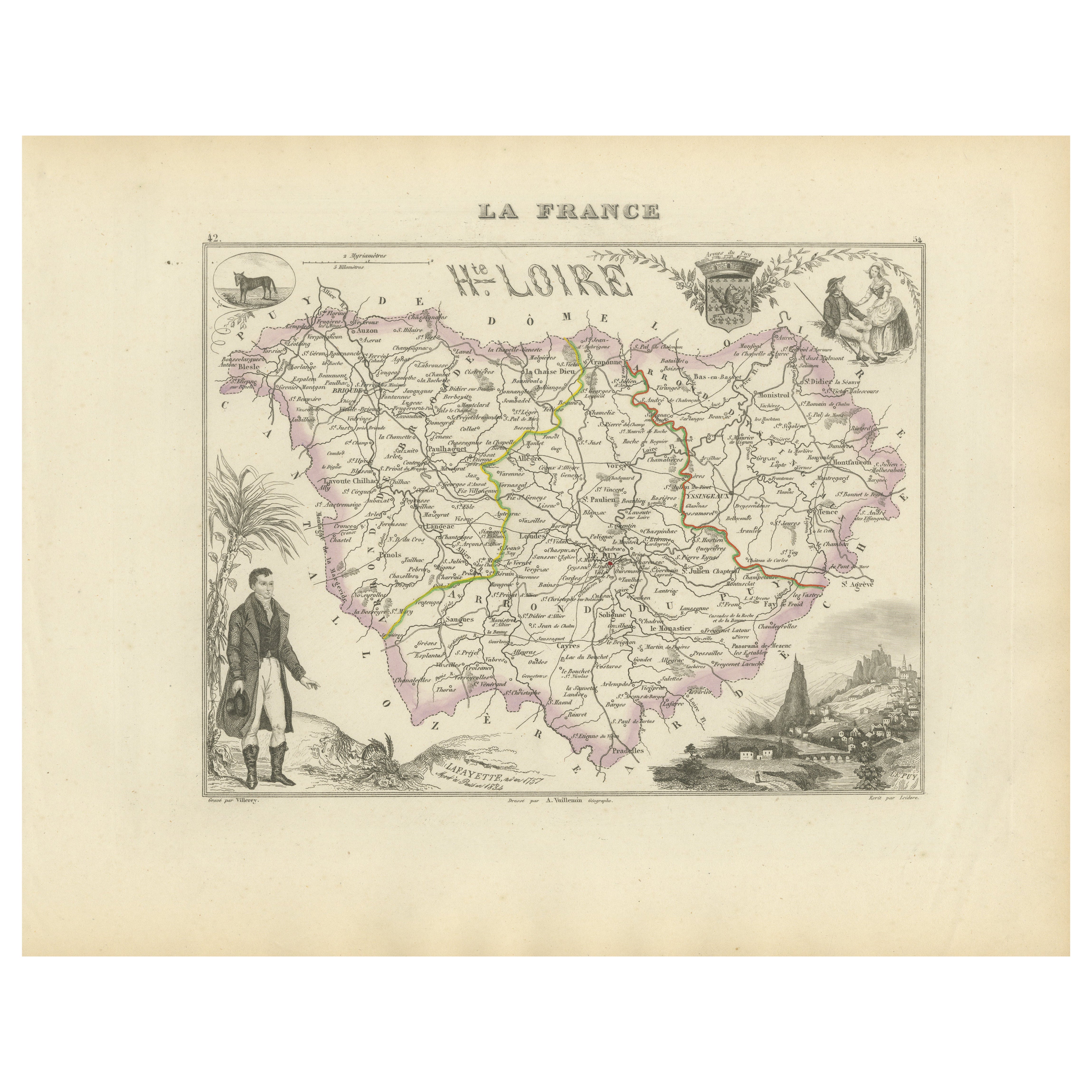
Map of Haute-Loire France with Le Puy-en-Velay by Vuillemin, 19th c
Located in Langweer, NL
Map of Haute-Loire France with Le Puy-en-Velay by Vuillemin, 19th c
This 19th-century hand-colored map of the Haute-Loire department in south-central France is from Alexandre Vuille...
Category
Antique Mid-19th Century French Maps
Materials
Paper
You May Also Like
Large 19th Century Map of France
Located in Pease pottage, West Sussex
Large 19th Century Map of France.
Remarkable condition, with a pleasing age worn patina.
Recently framed.
France Circa 1874.
Category
Antique Late 19th Century French Maps
Materials
Linen, Paper

Aude, France. Antique map of a French department, 1856
By Victor Levasseur
Located in Melbourne, Victoria
'Dept. de L' Aude', steel engraving with original outline hand-colouring., 1856, from Levasseur's 'Atlas National Illustre'.
This area of France is famous for its wide variety of v...
Category
19th Century Naturalistic Landscape Prints
Materials
Engraving

Lozere, France. Antique map of a French department, 1856
By Victor Levasseur
Located in Melbourne, Victoria
'Dept. de La Lozere', steel engraving with original outline hand-colouring., 1856, from Levasseur's 'Atlas National Illustre'.
This remote mountainous part of Languedoc is rural, s...
Category
19th Century Naturalistic Landscape Prints
Materials
Engraving

1771 Bonne Map of Poitou, Touraine and Anjou, France, Ric.a015
Located in Norton, MA
1771 Bonne Map of Poitou,
Touraine and Anjou, France
Ric.a015
1771 Bonne map of Potiou, Touraine and Anjou entitled "Carte des Gouvernements D'Anjou et du Saumurois, de la Touraine, du Poitou,du Pays d'aunis, Saintonge?Angoumois,"
Carte des gouvernements d'Anjou et du Saumurois, de la Touraine, du Poitou, du Pays d'Aunis, Saintonge-Angoumois. Projettee et assujettie au ciel par M. Bonne, Hyd. du Roi. A Paris, Chez Lattre, rue St. Jacques a la Ville de Bord(ea)ux. Avec priv. du Roi. 1771. Arrivet inv. & sculp., Atlas moderne ou collection de cartes sur toutes...
Category
Antique 17th Century Unknown Maps
Materials
Paper

Hautes-Pyrénées Map - Original Lithograph - 19th Century
Located in Roma, IT
Hautes-Pyrénées Map is an original lithograph realized by an Anonymous engraver of the 19th Century.
Printed in series of "France Pittoresque" at the top center.
The state of prese...
Category
19th Century Modern Figurative Prints
Materials
Paper, Lithograph

Aube, France. Antique map of a French department, 1856
By Victor Levasseur
Located in Melbourne, Victoria
'Dept. de L'Aube', steel engraving with original outline hand-colouring., 1856, from Levasseur's 'Atlas National Illustre'.
This area of France is known for its production of Chaou...
Category
19th Century Naturalistic Landscape Prints
Materials
Engraving

More Ways To Browse
Wine Map
American Revolutionary War
French Wine Map
Paisley Rugs and Carpets
Black And Chrome Lounge Chair
Vintage 1930 Dining Room Set
Antique Victorian Dining Tables
Environment Furniture
Italian Plastic Chairs
Made In Belgium
Black Crystal Glasses
French Mid Century Modern Rug
China Silk Rug
Chrome Glass Coffee Tables
Antique Italian Chairs
Antique Walnut Bar
Beni Ourain Rugs
French Iron And Glass Table