Items Similar to Map of the British Isles with Insets of London and Dublin, Leiden 1876


Want more images or videos?
Request additional images or videos from the seller
1 of 9
Map of the British Isles with Insets of London and Dublin, Leiden 1876
$383.10
£286.49
€320
CA$527.89
A$575.91
CHF 304.94
MX$6,901.05
NOK 3,883.60
SEK 3,551.26
DKK 2,437.18
About the Item
Title: Map of the British Isles with Insets of London and Dublin, Leiden 1876
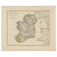
This detailed 19th-century Dutch map, titled “Het Britsche Rijk,” was published in 1876 in the Nieuwe Hand-Atlas der Aarde in haren Tegenwoordigen Toestand by M. Frijlink, revised by A. van Otterloo, and printed by D. Noothoven van Goor in Leiden. The map presents a comprehensive view of the British Isles—England, Scotland, Wales, and Ireland—finely engraved and delicately hand-colored to distinguish political boundaries and geographic divisions.
Each country is outlined in a distinct color: red for England, yellow for Scotland, green for Wales, and blue for Ireland. The map includes all major cities, towns, rivers, and mountain ranges, with excellent clarity and proportional accuracy. Insets along the right and lower margins provide enlarged views of London, Dublin, and Edinburgh, while smaller maps detail the Channel Islands and the Isles of Man and Scilly. A full list of counties for each nation appears in the left margin, serving as an essential reference for students and geographers.
This map reflects the educational and scientific focus of Dutch cartography in the late 19th century, when accuracy and legibility were paramount. Its balanced composition and neat typography make it a fine example of the precision printing typical of Noothoven van Goor’s Leiden press, which was renowned for its geographic and academic publications.
Condition report:
Good condition with gentle age toning and light scattered foxing, mostly in the outer margins. Original center fold as issued. The engraved lines are sharp, and the original coloring remains soft and well-preserved. No tears or repairs.
Framing tips:
This map is best presented with a cream or light grey mat and a narrow black or walnut frame. Its balanced design and refined details make it an elegant choice for a study, office, or library, especially when paired with other European maps from the same atlas.
Technique: Lithograph with original hand-coloring
Maker: M. Frijlink
A. van Otterloo, published by D. Noothoven van Goor, Leiden, 1876
- Dimensions:Height: 21.66 in (55 cm)Width: 17.33 in (44 cm)Depth: 0.01 in (0.2 mm)
- Materials and Techniques:
- Place of Origin:
- Period:
- Date of Manufacture:1876
- Condition:Good condition with gentle age toning and light scattered foxing, mostly in the outer margins. Original center fold as issued. The engraved lines are sharp, and the original coloring remains soft and well-preserved. No tears or repairs.
- Seller Location:Langweer, NL
- Reference Number:Seller: BG-12788-91stDibs: LU3054347454442
About the Seller
5.0
Recognized Seller
These prestigious sellers are industry leaders and represent the highest echelon for item quality and design.
Platinum Seller
Premium sellers with a 4.7+ rating and 24-hour response times
Established in 2009
1stDibs seller since 2017
2,791 sales on 1stDibs
Typical response time: <1 hour
- ShippingRetrieving quote...Shipping from: Langweer, Netherlands
- Return Policy
More From This Seller
View AllOriginal Antique Map of the United Kingdom and Ireland, Published in 1875
Located in Langweer, NL
Antique map titled 'Iles Britanniques ou Royaume-Uni de la Grande Bretagne (..)'. Large map of the United Kingdom and Ireland. This map originates from...
Category
Antique Late 19th Century French Maps
Materials
Paper

$293 Sale Price
30% Off
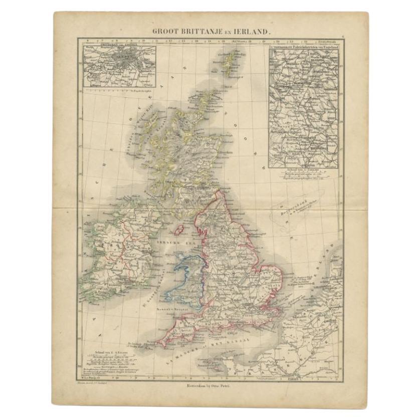
Antique Map of the United Kingdom and Ireland, c.1873
Located in Langweer, NL
Antique map titled 'Groot Brittanje en Ierland'. Old map depicting the United Kingdom and Ireland, with inset maps of London and factory districts of the UK. This map originates from...
Category
Antique 19th Century Maps
Materials
Paper

$119 Sale Price
20% Off
Antique Map of Britain
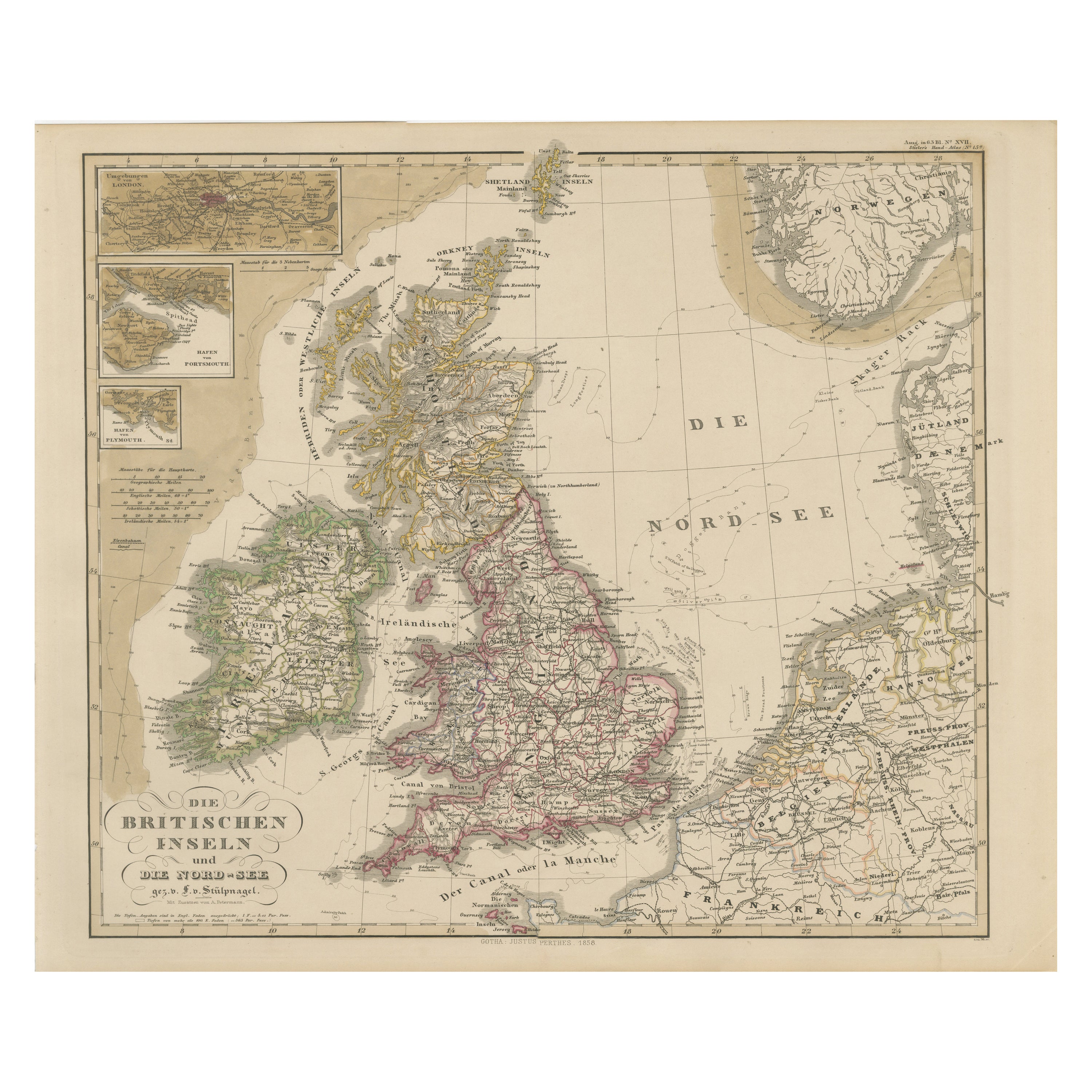
Ireland with North Sea Detail – 1856 Stülpnagel
Located in Langweer, NL
Antique Map of the British Isles & North Sea by Stülpnagel, 1856
This beautifully detailed 1856 map titled *"Die Britischen Inseln und die Nord-See"* was drawn by F. von Stülpnagel ...
Category
Antique Mid-19th Century German Maps
Materials
Paper
Antique Map of the United Kingdom and Ireland, 1852
Located in Langweer, NL
Antique map titled 'Groot-Brittanje en Ierland'. Map of the United Kingdom and Ireland. This map originates from 'School-Atlas van alle deelen der Aarde' by Otto Petri.
Artists a...
Category
Antique 19th Century Maps
Materials
Paper

$124 Sale Price
20% Off
Antique Map of England and Wales by Johnson
1872
Located in Langweer, NL
Antique map titled 'Johnson's England and Wales'. Original map of England and Wales. This map originates from 'Johnson's New Illustrated Family Atlas of the World' by A.J. Johnson. P...
Category
Antique Late 19th Century American Maps
Materials
Paper

$224 Sale Price
25% Off
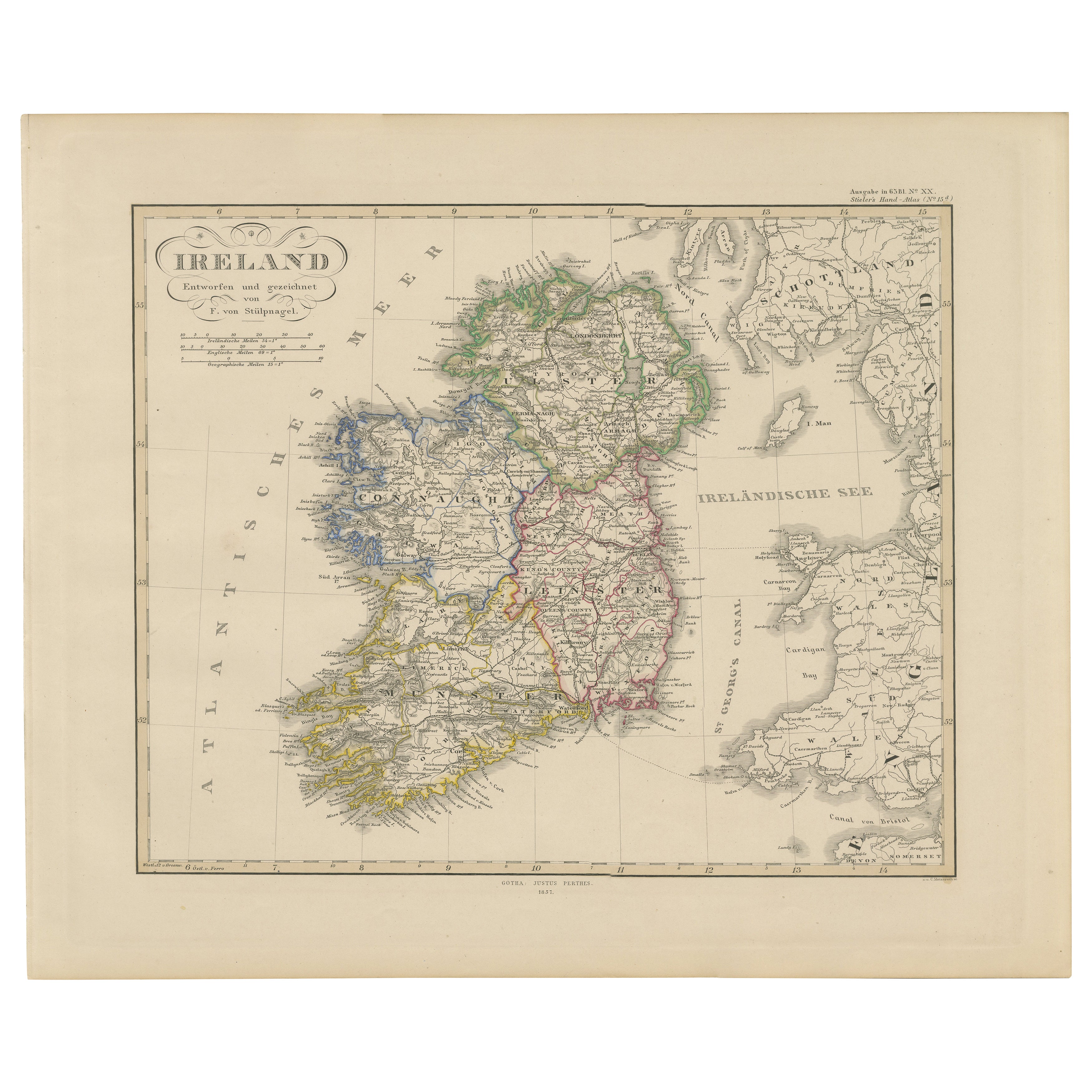
Ireland Map – Provincial and County Divisions 1851
Located in Langweer, NL
Ireland Map – Provincial and County Divisions 1851
This fine antique print shows Ireland titled simply “Ireland,” published in 1851 by Justus Perthes in Gotha as part of Adolf Stiel...
Category
Antique Mid-19th Century German Maps
Materials
Paper
You May Also Like
England and Wales, Northern Part. Century Atlas antique vintage map
Located in Melbourne, Victoria
'The Century Atlas. England and Wales, Northern Part'
Original antique map, 1903.
Central fold as issued. Map name and number printed on the reverse corners.
Sheet 29.5cm by 40cm.
Category
Early 20th Century Victorian More Prints
Materials
Lithograph

Original Antique Map of Scotland by Dower, circa 1835
Located in St Annes, Lancashire
Nice map of Scotland
Drawn and engraved by J.Dower
Published by Orr & Smith. C.1835
Unframed.
Free shipping
Category
Antique 1830s English Maps
Materials
Paper

Large Original Vintage Map of the United Kingdom, circa 1920
Located in St Annes, Lancashire
Great map of The United Kingdom
Unframed
Original color
By John Bartholomew and Co. Edinburgh Geographical Institute
Published, circa 1920
Free shipping.
Category
Vintage 1920s British Maps
Materials
Paper

Large Original Antique Map of Ireland. C.1900
Located in St Annes, Lancashire
Fabulous map of Ireland
Original color.
Engraved and printed by the George F. Cram Company, Indianapolis.
Published, C.1900.
Unframed.
Free shipping.
Category
Antique 1890s American Maps
Materials
Paper

Original Antique Map of Ireland- Kerry. C.1840
Located in St Annes, Lancashire
Great map of Kerry
Steel engraving
Drawn under the direction of A.Adlard
Published by How and Parsons, C.1840
Unframed.
Category
Antique 1840s English Maps
Materials
Paper

Vicinity of London, England, United Kingdom. Century Atlas antique map
Located in Melbourne, Victoria
'The Century Atlas. Vicinity of London, England, United Kingdom.'
Original antique map, 1903.
Central fold as issued. Map name and number printed on the reverse corners.
Sheet 29.5...
Category
Early 20th Century Victorian More Prints
Materials
Lithograph
