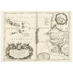
Items Similar to Map of Cape Verde and the Mouth of the River Niger by Coronelli, 1691

Want more images or videos?
Request additional images or videos from the seller
1 of 11
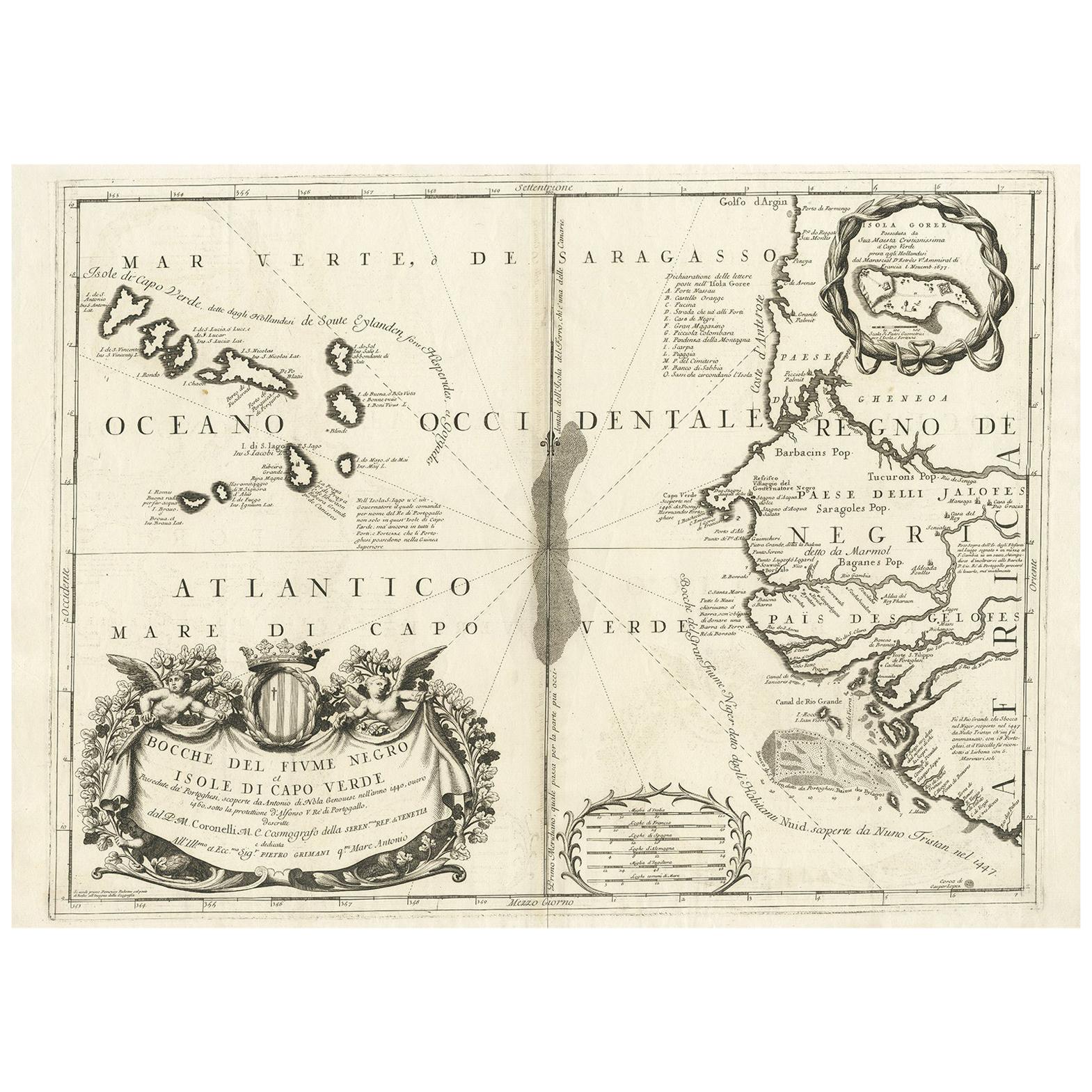
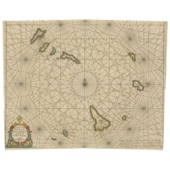
Map of Cape Verde and the Mouth of the River Niger by Coronelli, 1691
$1,257.75
£938.97
€1,060
CA$1,747.40
A$1,879.57
CHF 1,004.50
MX$22,154.82
NOK 12,664.37
SEK 11,577.64
DKK 8,078.39
About the Item
Map of Cape Verde and the Mouth of the River Niger by Coronelli, 1691
This finely engraved map, titled "Bocche del Fiume Negro et Isole di Capo Verde," was created in 1691 by Vincenzo Maria Coronelli, a Venetian cosmographer, cartographer, and Franciscan friar who was among the most influential mapmakers of the late 17th century. Known for his scientific precision and artistic flourish, Coronelli produced this map as part of his celebrated *Atlante Veneto* series, a monumental geographical work that contributed to Europe's understanding of distant regions during the Age of Exploration.
The map focuses on the Atlantic coastal region of West Africa, particularly the Cape Verde Islands and the adjacent coastline near the mouth of the River Niger. Prominently featured are the islands of the Cape Verde archipelago, rendered in vivid hand-coloring, with clear indications of individual islands such as Santiago, Boa Vista, Maio, and São Vicente. The African coast is shown in detailed relief, including regions historically inhabited by the Jaloff (Wolof) people, and settlements such as Capo Verde, Bissau, and the depiction of the Island of Gorée, an important trading post.
This map reflects the maritime interests of European powers in the Atlantic during the late 1600s and captures the navigational routes and knowledge of the region as it was understood by European cartographers. The cartouche, richly decorated with allegorical figures and a heraldic crest, underscores the baroque aesthetics of Coronelli’s work.
As a scientific and artistic object, the map is a testament to the ambition of early modern geography. Coronelli’s maps were esteemed not only for their accuracy but also for their visual appeal, often combining scholarly detail with elaborate ornamentation.
Condition:
Very good to excellent early impression with original hand-coloring. The strong paper is clean and well-preserved with wide margins and only minor age-related toning to the edges. Center fold as issued.
Framing tips:
Frame this piece in a classic walnut or dark oak frame with a warm cream or off-white mat to complement the aged paper and hand-coloring. Avoid overly modern styles to preserve the historical character of the print. Non-reflective museum glass is recommended.
- Dimensions:Height: 19.34 in (49.1 cm)Width: 27.41 in (69.6 cm)Depth: 0.01 in (0.2 mm)
- Materials and Techniques:Paper,Engraved
- Period:Late 17th Century
- Date of Manufacture:1691
- Condition:Very good to excellent early impression with original hand-coloring. Paper is clean and well-preserved with wide margins and only minor age-related toning to the edges. Center fold as issued.
- Seller Location:Langweer, NL
- Reference Number:Seller: BG-13730-21stDibs: LU3054345364082
About the Seller
5.0
Recognized Seller
These prestigious sellers are industry leaders and represent the highest echelon for item quality and design.
Platinum Seller
Premium sellers with a 4.7+ rating and 24-hour response times
Established in 2009
1stDibs seller since 2017
2,836 sales on 1stDibs
Typical response time: 1 hour
- ShippingRetrieving quote...Shipping from: Langweer, Netherlands
- Return Policy
More From This Seller
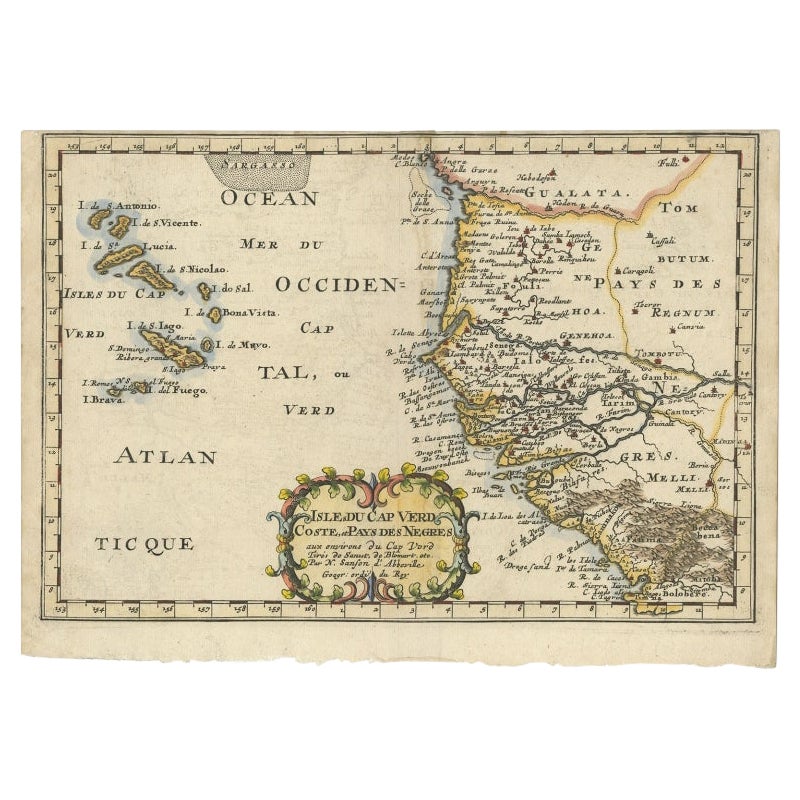
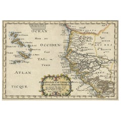
View AllAntique Map of the Cape Verde Islands and Part of Senegal, West Africa, 1690
Located in Langweer, NL
Antique map titled 'Bocche del Fivme Negro et Isole di Capo Verde'. Beautiful double-page map of the Cape Verde Islands and part of the coast of Senegal, with large decorative cartou...
Category
Antique 17th Century Italian Maps
Materials
Paper

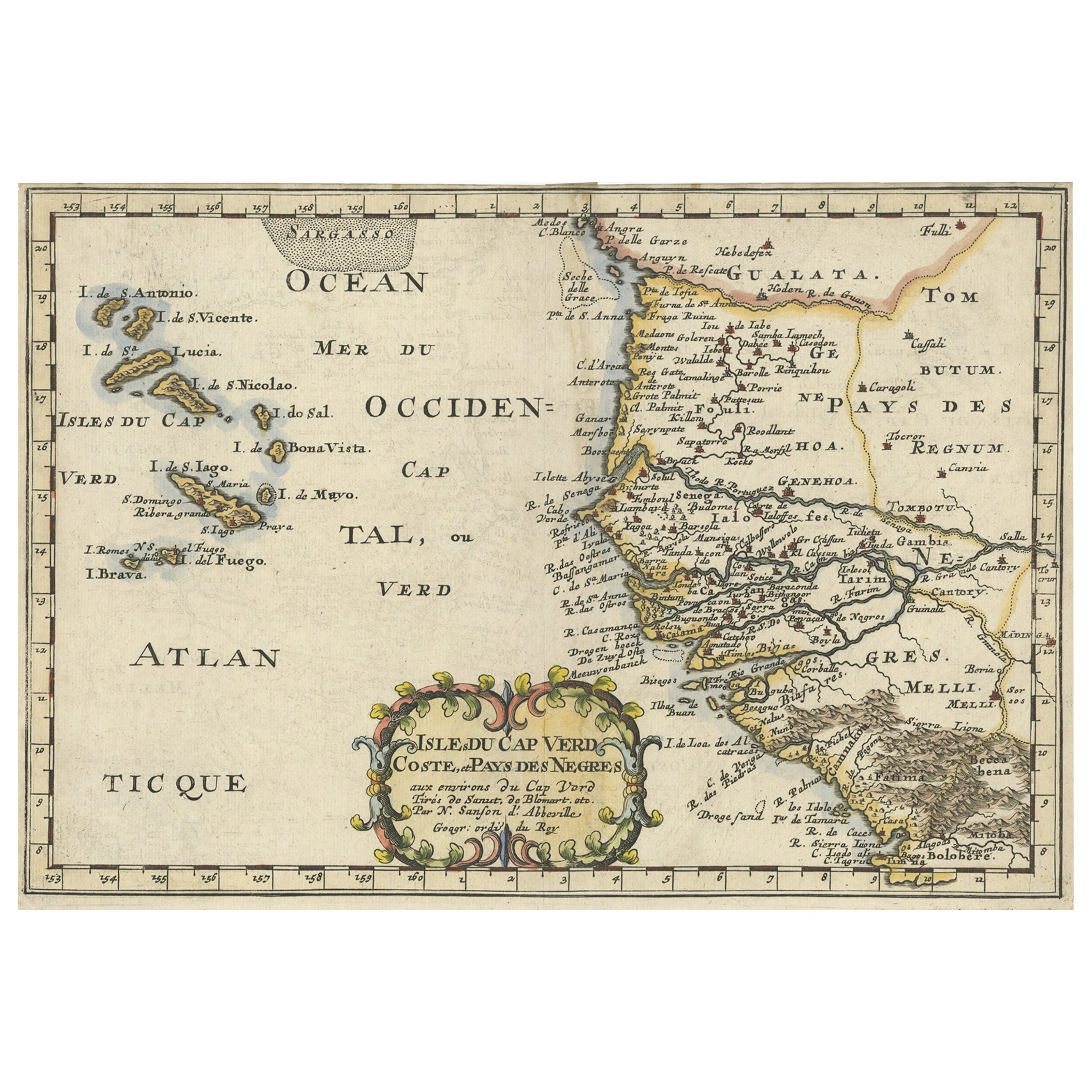
Antique Map of Western Africa and the Cape Verde Islands by Coronelli, 1691
By Vincenzo Coronelli
Located in Langweer, NL
Antique map titled 'Bocche del Fiume Negro et Isole di Capo Verde'. Antique map of Western Africa with the Cape Verde Islands and an inset of Goree Island. Originates from 'Atlante V...
Category
Antique Late 17th Century Italian Maps
Materials
Paper
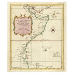
Antique Map of the West African Coast and the Cape Verde Islands, c.1680
Located in Langweer, NL
Antique map Africa titled 'Isles du Cap Verd Coste et Pays des Negres'. Antique map of the coast of Africa and the Cape Verde islands.
Artists and...
Category
Antique 17th Century Maps
Materials
Paper

$341 Sale Price
20% Off
Antique Map of the Coast of Africa and the Cape Verde Islands, ca.1680
Located in Langweer, NL
Antique map Africa titled 'Isles du Cap Verd Coste et Pays des Negres'.
Antique map of the coast of Africa and the Cape Verde islands.
Artis...
Category
Antique 1680s Maps
Materials
Paper
$332 Sale Price
20% Off
East African Coast – French Map by Bellin, Zanzibar to Arabia, 1740
Located in Langweer, NL
East African Coast – French Map by Bellin, Zanzibar to Arabia, 1740
This important French map depicts the eastern coast of Africa from Mozambique and Zanzibar northward to the Horn ...
Category
Antique 1740s French Maps
Materials
Paper
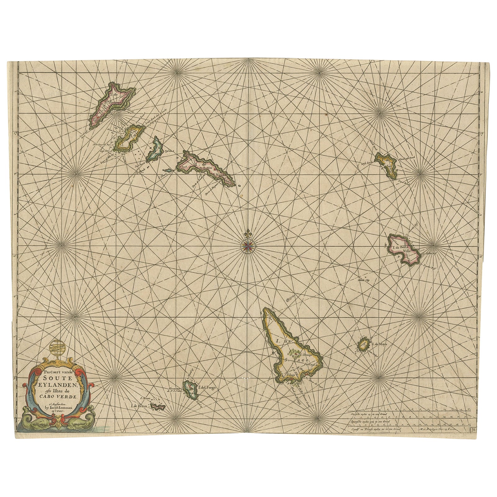
Antique Map of the Cape Verde Islands, Africa, ca.1670
Located in Langweer, NL
Antique map titled 'Pascaert van de Soute Eylanden ofte Ilhas de Cabo Verde'.
This map depicts the Cape Verde Islands (Africa). Islands titled 'Ile de B...
Category
Antique 1670s Maps
Materials
Paper
$626 Sale Price
20% Off
You May Also Like
West Africa: A 17th Century Hand-Colored Map by Mercator/Hondius
By Gerard Mercator
Located in Alamo, CA
A 17th century hand-colored map entitled "Guineae Nova Descriptio" by Gerard Mercator and Jodocus Hondius, published in their 'Atlas Minor' in Amsterdam in 1635. It is focused on the...
Category
1630s Landscape Prints
Materials
Engraving

West Coast of Africa; Guinea
Sierra Leone: Bellin 18th Century Map
Located in Alamo, CA
This is a Jacques Bellin copper-plate map entitled "Partie de la Coste de Guinee Dupuis la Riviere de Sierra Leona Jusquau Cap das Palmas", depicting the coast of Guinea and Sierra L...
Category
1740s Old Masters Landscape Prints
Materials
Engraving

West Coast of Africa, Guinea
Sierra Leone: An 18th Century Map by Bellin
By Jacques-Nicolas Bellin
Located in Alamo, CA
Jacques Bellin's copper-plate map entitled "Partie de la Coste de Guinee Dupuis la Riviere de Sierra Leona Jusquau Cap das Palmas", depicting the coast of Guinea and Sierra Leone in ...
Category
Antique Mid-18th Century French Maps
Materials
Paper

Antique Map - Mare Pacificum - Etching by Johannes Janssonius - 1650s
By Johannes Janssonius
Located in Roma, IT
Mare Pacificum is an antique map realized in 1650 by Johannes Janssonius (1588-1664).
The Map is Hand-colored etching, with coeval watercolorang.
Good conditions with slight foxing...
Category
1650s Modern Figurative Prints
Materials
Etching

Antique Map - Mar Di Athiopia - Etching by Johannes Janssonius - 1650s
By Johannes Janssonius
Located in Roma, IT
Antique Map - Mar Di Athiopia is an antique map realized in 1650 by Johannes Janssonius (1588-1664).
The Map is Hand-colored etching, with coeval watercolorang.
Good conditions wit...
Category
1650s Modern Figurative Prints
Materials
Etching

Africa: A Large 17th Century Hand-colored Map By Sanson and Jaillot
By Nicholas Sanson d
Abbeville
Located in Alamo, CA
This large original hand-colored copperplate engraved map of Africa entitled "L'Afrique divisee suivant l'estendue de ses principales parties ou sont distingues les uns des autres, L...
Category
1690s Landscape Prints
Materials
Engraving

More Ways To Browse
Heraldic Crest
Cape Antique Furniture
Antique Capo
Paisley Rugs and Carpets
Black And Chrome Lounge Chair
Vintage 1930 Dining Room Set
Antique Victorian Dining Tables
Environment Furniture
Italian Plastic Chairs
Made In Belgium
Black Crystal Glasses
French Mid Century Modern Rug
China Silk Rug
Chrome Glass Coffee Tables
Antique Italian Chairs
Antique Walnut Bar
Beni Ourain Rugs
French Iron And Glass Table