Items Similar to Map of Constantinople, Bosphorus, the Coasts of Greece and the Archipelago, 1785


Want more images or videos?
Request additional images or videos from the seller
1 of 10
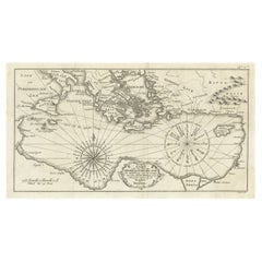
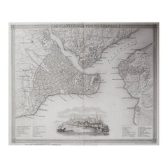
Map of Constantinople, Bosphorus, the Coasts of Greece and the Archipelago, 1785
$1,759.85
$2,933.0840% Off
£1,316.07
£2,193.4540% Off
€1,470
€2,45040% Off
CA$2,424.98
CA$4,041.6340% Off
A$2,645.59
A$4,409.3240% Off
CHF 1,400.82
CHF 2,334.7140% Off
MX$31,701.70
MX$52,836.1740% Off
NOK 17,840.27
NOK 29,733.7840% Off
SEK 16,313.60
SEK 27,189.3440% Off
DKK 11,195.79
DKK 18,659.6640% Off
About the Item
This is a large 1785 map titled "Carte de la Ville de Constantinople et du Bosphore de Thrace", which includes detailed maps of Constantinople (modern-day Istanbul), the Bosphorus Strait, the Sea of Marmara, and the coasts of Greece and the Aegean Archipelago. The map offers a comprehensive view of one of the most strategically significant regions of the Ottoman Empire during the late 18th century.
The map is associated with Pierre François Tardieu, a prominent French engraver and cartographer. The Tardieu family was well-known for their high-quality engravings and maps during the 18th and 19th centuries. Pierre François Tardieu, in particular, produced many fine maps and was often involved in the publication of detailed geographical works.
Tardieu's maps are known for their precision and craftsmanship, and this map of Constantinople and the Bosphorus reflects the typical attention to detail seen in his work. The map includes multiple insets, such as the coasts of Greece and the Aegean Archipelago, providing a wide scope of geographic and strategic information.
Why is this map so interesting?
This map is intriguing because it captures the strategic importance of Constantinople and the Bosphorus during a time when the Ottoman Empire was a major force in global geopolitics. The Bosphorus Strait was (and still is) a key maritime passage connecting the Black Sea with the Mediterranean. Control over this region meant influence over vital trade routes. The inset of the Topkapi Palace (Sublime Porte) adds another layer of historical interest, as it depicts the seat of Ottoman imperial power.
The broader context of the map, including the coasts of Greece and the Aegean, provides insight into the geopolitical landscape of the Eastern Mediterranean in the late 18th century. Maps like this were essential for political and commercial navigation, as the Mediterranean and its surrounding regions were critical trade and military zones.
Keywords for this map:
Pierre François Tardieu, Constantinople, Bosphorus, Thrace, Ottoman Empire, Sea of Marmara, Aegean Archipelago, Topkapi Palace, Sublime Porte, 1785 map, Eastern Mediterranean, historical map, French cartography, maritime trade, strategic map, Ottoman Constantinople, Tardieu map.
This map remains a valuable artifact for scholars, collectors, and enthusiasts of historical cartography, providing a window into the geopolitics of the 18th-century Eastern Mediterranean world.
- Dimensions:Height: 25.6 in (65 cm)Width: 37.41 in (95 cm)Depth: 0 in (0.02 mm)
- Materials and Techniques:Paper,Engraved
- Place of Origin:
- Period:1780-1789
- Date of Manufacture:1785
- Condition:Condition: good, given age. Original folding line as issued. General age-related toning and/or occasional minor defects from handling. Short margins with a few small tears touching the platemark. Please study scan carefully.
- Seller Location:Langweer, NL
- Reference Number:Seller: BG-13649-11stDibs: LU3054341646742
About the Seller
5.0
Recognized Seller
These prestigious sellers are industry leaders and represent the highest echelon for item quality and design.
Platinum Seller
Premium sellers with a 4.7+ rating and 24-hour response times
Established in 2009
1stDibs seller since 2017
2,792 sales on 1stDibs
Typical response time: <1 hour
- ShippingRetrieving quote...Shipping from: Langweer, Netherlands
- Return Policy
More From This Seller
View AllAntique Map of the Persian Gulf and Caspian Sea Region by R. Bonne, 1780
Located in Langweer, NL
Antique print titled 'Carte de la Perse, de la Georgie, et de la Tartarie Independante'. Shows the region from the Persian Gulf and Caspian Sea in the wes...
Category
Antique Late 18th Century French Maps
Materials
Paper

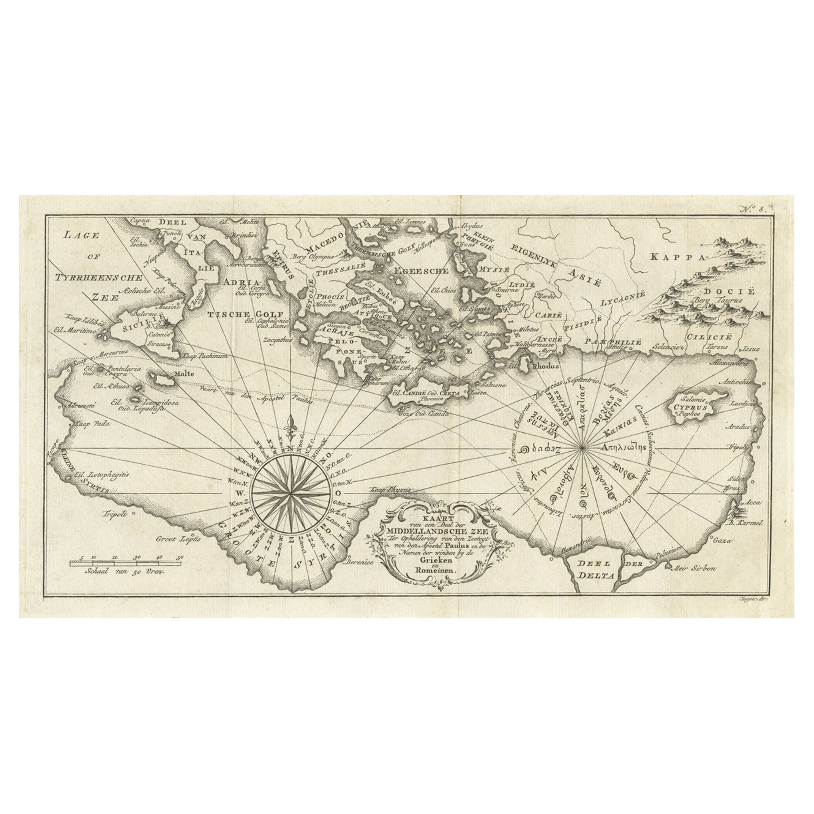
Old Dutch Map of the Region Around the Mediterranean Sea, 1773
Located in Langweer, NL
Antique map titled 'Kaart van een Deel der Middelandsche Zee (..)'.
Old map of the region around the Mediterranean Sea. Originates from the first Dutch editon of an interesting t...
Category
Antique 1770s Maps
Materials
Paper
$344 Sale Price
20% Off
Antique Map of the Eastern Mediterranean, C.1710
Located in Langweer, NL
Antique map Middle East titled 'De Beschryving van de Reysen Pauli en van de Andere Apostelen'. Antique map of the Eastern Mediterranean with det...
Category
Antique 18th Century Maps
Materials
Paper

Antique Map of the Bay of Cordes and Surroundings by Hawkesworth, 1774
Located in Langweer, NL
Antique print titled 'Baye et Havre de Cordes (..)'. Four maps on the one sheet of; Cordes Bay, Port Famine, Woods Pay, Port Gallant, Fortescue Bay, Chile based on the voyage of John...
Category
Antique 18th Century Maps
Materials
Paper
$107 Sale Price
20% Off
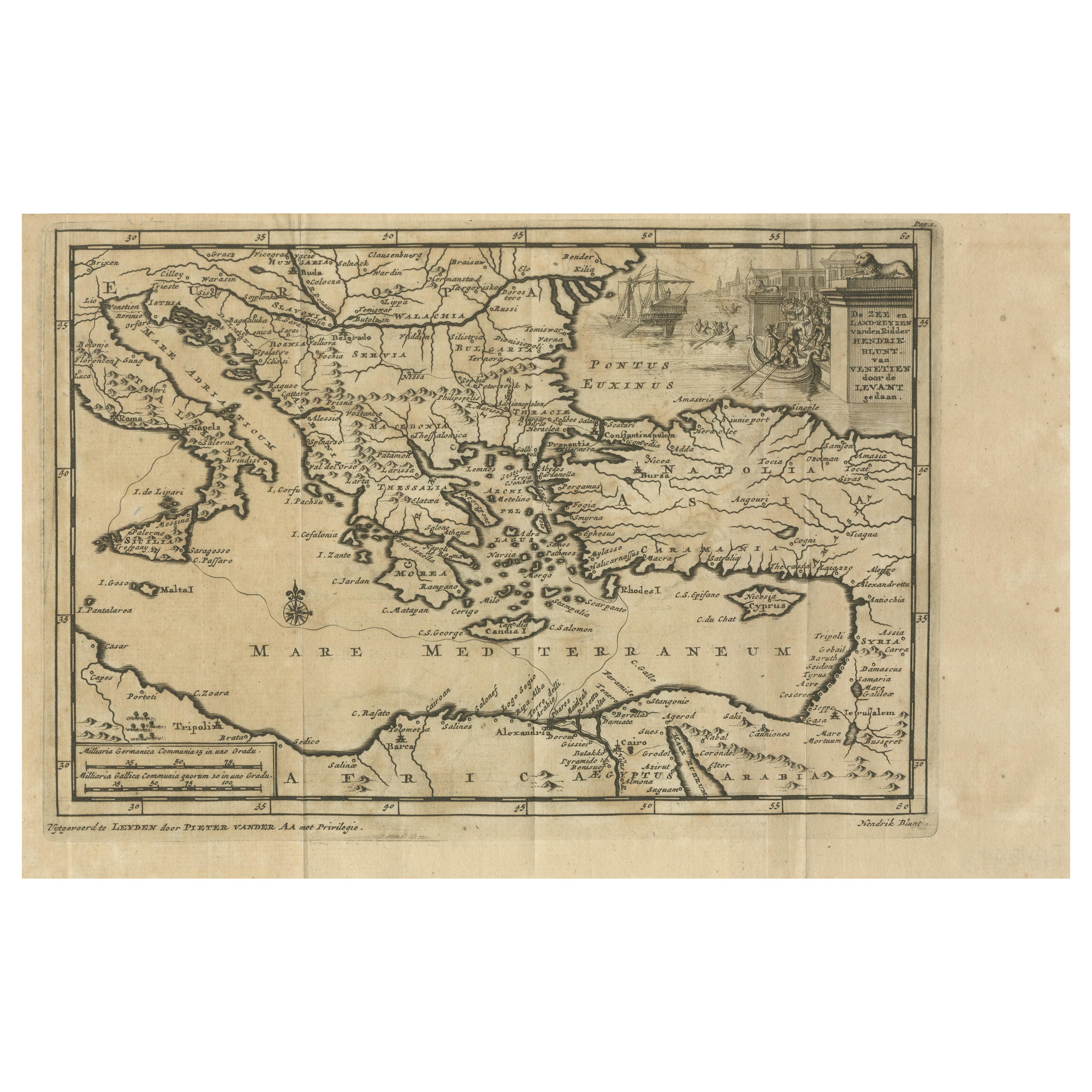
Venetian Trade Routes in the Levant – Antique Map by Pieter van der Aa, ca.1720
Located in Langweer, NL
Venetian Trade Routes in the Levant – Antique Map by Pieter van der Aa, Early 18th Century
This finely engraved map, published by Pieter van der Aa in Leiden, provides a detailed d...
Category
Antique 1720s Maps
Materials
Paper
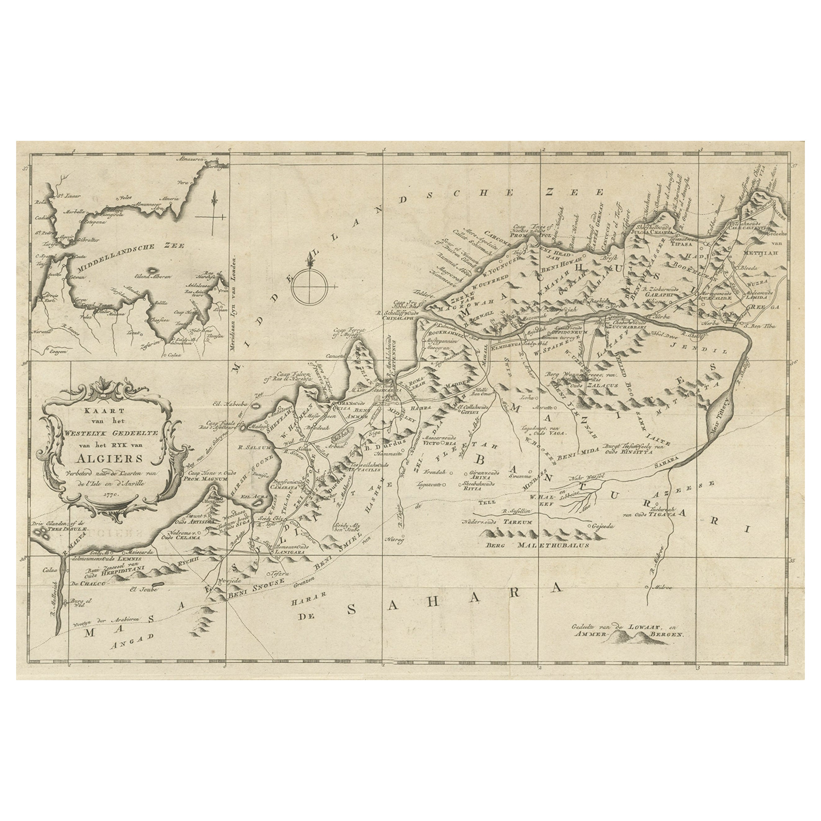
Old Map of the Western Region of the Kingdom of Algiers, Algeria, 1773
Located in Langweer, NL
Antique map titled 'Kaart van het Westelyk Gedeelte van het Ryk van Algiers'.
Old map of the western region of the Kingdom of Algiers, Algeria. Originates from the first Dutch ed...
Category
Antique 1770s Maps
Materials
Paper
$363 Sale Price
20% Off
You May Also Like
Original Antique Map of Ancient Greece, Achaia, Corinth, 1786
Located in St Annes, Lancashire
Great map of Ancient Greece. Showing the region of Thessaly, including Mount Olympus
Drawn by J.D. Barbie Du Bocage
Copper plate engraving by P.F Tardieu
Original hand color...
Category
Antique 1780s French Other Maps
Materials
Paper

Original Antique Map or City Plan of Istanbul, Turkey. Circa 1835
Located in St Annes, Lancashire
Nice map of Istanbul
Drawn and engraved by J.Dower
Published by Orr & Smith. C.1835
Unframed.
Free shipping
Category
Antique 1830s English Maps
Materials
Paper
Original Antique Map of Ancient Greece- Boeotia, Thebes, 1787
Located in St Annes, Lancashire
Great map of Ancient Greece. Showing the region of Boeotia, including Thebes
Drawn by J.D. Barbie Du Bocage
Copper plate engraving by P.F T...
Category
Antique 1780s French Other Maps
Materials
Paper

Map Of The Island Of Cuba - Guillaume Thomas Raynal (1711-1796)
Located in Porto, PT
This historical map of the Island of Cuba was produced in the late 18th century and is taken from an edition of “Atlas de toutes les parties connues du globe terrestre” by the French...
Category
Antique 18th Century Prints
Materials
Glass, Paper

1814 Map of "Russian Empire" Ric.r032
Located in Norton, MA
1814 Map of
"Russian Empire"
Ric.r032
Russian Empire. Description: This is an 1814 John Thomson map of the Russian Empire. The map depicts the region from the Baltic Sea, Prussia, and Sweden to the Aleutian Islands and from the Arctic Ocean to the Yellow River. Highly detailed, myriad cities, towns, and villages are labeled throughout, including St. Petersburg, Moscow, Minsk, Kiev, and Kharkov. Rivers and mountain ranges are also identified, as are islands and numerous locations along the coastlines. It is important to note that the long-disputed sea between Korea and Japan is identified as the 'Sea of Japan.
Historical Context:
In 1815, Tsarist Russia emerged from the Napoleonic Wars economically insolvent and politically fearful of the Revolutionary fervor that had just swept through Europe. In order to shore up Russia's economic position, the Tsars began an aggressive series of expansions into the Caucuses and Central Asia that would vastly increase the landmass of the Russian Empire.
Publication History
Thomson maps are known for their stunning color, awe inspiring size, and magnificent detail. Thomson's work, including this map, represents some of the finest cartographic art...
Category
Antique 19th Century Unknown Maps
Materials
Paper

Map of Ancient Greece - Original Etching by Antonio Zatta - 1785
Located in Roma, IT
This Map of ancient Greek is an etching realized by Antonio Zatta in Venice in 1785.
The state of preservation of the artwork is good expect for the worn paper.
Mounted on a cardbo...
Category
1770s Landscape Prints
Materials
Etching

More Ways To Browse
Istanbul Antique
18th Century Engravings
Antique Carved Wood Chair
Black Scandinavian Modern Dining Chairs
Dutch Mid Century Modern Table
Gold Modern Coffee Table
Iconic Modern Furniture
Midcentury Modern Gray Glass Vase
Round Glass Coffee Tables
Vintage Cave
18th Century Wood Side Tables
Antique Hand Carved Dining Room Sets
Mid Century Modern Pitcher
Vintage Italian Leather Dining Chair
Vintage Movie Posters
Blue Green Wool And Silk Rug
Brown Sheepskin Chair
Vintage Brass Bar Carts