Want more images or videos?
Request additional images or videos from the seller
1 of 15
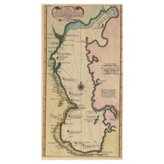
Map of Florida, Louisiana and the Bahamas – Set of Rare French Sea Charts, 1777
$3,479.88List Price
About the Item
- Dimensions:Height: 18.9 in (48 cm)Width: 24.22 in (61.5 cm)Depth: 0.01 in (0.2 mm)
- Sold As:Set of 2
- Materials and Techniques:Paper,Engraved
- Period:1770-1779
- Date of Manufacture:1777
- Condition:Repaired: The eastern sheet has undergone archival repairs to address a chip in the top blank margin. Crisp impression with attractive hand coloring, printed on watermarked paper. A few short edge tears, none of which intrude into the image area. Overall, the sheets are well-preserved, with excellent color retention and clear, legible labeling.
- Seller Location:Langweer, NL
- Reference Number:Seller: BHZ113781stDibs: LU3054342599852
About the Seller
5.0
Recognized Seller
These prestigious sellers are industry leaders and represent the highest echelon for item quality and design.
Platinum Seller
Premium sellers with a 4.7+ rating and 24-hour response times
Established in 2009
1stDibs seller since 2017
2,819 sales on 1stDibs
Typical response time: 1 hour
Authenticity Guarantee
In the unlikely event there’s an issue with an item’s authenticity, contact us within 1 year for a full refund. DetailsMoney-Back Guarantee
If your item is not as described, is damaged in transit, or does not arrive, contact us within 7 days for a full refund. Details24-Hour Cancellation
You have a 24-hour grace period in which to reconsider your purchase, with no questions asked.Vetted Professional Sellers
Our world-class sellers must adhere to strict standards for service and quality, maintaining the integrity of our listings.Price-Match Guarantee
If you find that a seller listed the same item for a lower price elsewhere, we’ll match it.Trusted Global Delivery
Our best-in-class carrier network provides specialized shipping options worldwide, including custom delivery.You May Also Like
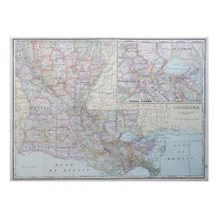
Original Antique Map of the American State of Louisiana, 1903
Located in St Annes, Lancashire
Antique map of Louisiana
Published By A & C Black. 1903
Original colour
Good condition
Unframed.
Free shipping
Category
Antique Early 1900s English Maps
Materials
Paper

$49
Free Shipping
H 11.5 in W 16.25 in D 0.07 in
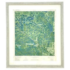
Vintage 50s Topographical Map of the Florida Keys
Located in West Palm Beach, FL
A fabulous vintage 50 original topographical map. A depiction of the Florida Keys and the surrounding waters. Part of a set of three maps. The other t...
Category
Mid-20th Century American Maps
Materials
Glass, Wood, Paper
Large Original Antique Map of Louisiana, USA, C.1900
Located in St Annes, Lancashire
Fabulous map of Louisiana.
Original color.
Engraved and printed by the George F. Cram Company, Indianapolis.
Published, c.1900.
Unframed.
Repair ...
Category
Antique 1890s American Maps
Materials
Paper
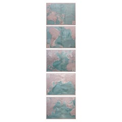
Set of 5 Large Original Vintage Sea Charts, circa 1920
Located in St Annes, Lancashire
5 great maps or charts of the oceans
I particularly like the color of these maps
Unframed
Original color
By John Bartholomew and Co. Edinburgh Geographical Institute
Published, ...
Category
Vintage 1920s British Maps
Materials
Paper
$180 / set
Free Shipping
H 17.5 in W 22.5 in D 0.07 in
Super Rare Antique French Map of Chine and the Chinese Empire, 1780
Located in Amsterdam, Noord Holland
Super Rare Antique French Map of Chine and the Chinese Empire, 1780
Very nice map of Asia. 1780 Made by Bonne.
Additional information:
Type: Map
...
Category
Antique 18th Century European Maps
Materials
Paper

$438 Sale Price
49% Off
H 13.78 in W 10.04 in D 0.04 in
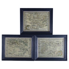
Rare Set of 3 Map Samplers by A Charles. Italy, Spain
France
Located in Chelmsford, Essex
Set of 3 Map Samplers by A Charles. All depict countries, cities, seas and landmarks of the respective countries. The first entitled, 'SPAIN and PORTUGAL'. The second, 'MAP OF FRANCE...
Category
Antique Early 19th Century English Tapestries
Materials
Linen
University Chart “Black Map of North America
Located in Godshill, Isle of Wight
University Chart “Black Map of North America
W&A K Johnston’s Charts of Physical Maps By G W Bacon,
This is a Black Physical map of North A...
Category
Early 20th Century Industrial Maps
Materials
Linen

Set of (14) Vintage Anatomy Charts by American Map Co. - sold individually
Located in Philadelphia, PA
Set of (14) Vintage Anatomy Charts
American Map Co. - Circa 1950.
14 Total Charts - Sold Individually -( 14 available )
( discounted to buy as a set )
29" x 37" unfolded
9.5" x 12...
Category
Mid-20th Century American Mid-Century Modern Posters
Materials
Paper

$100 / item
H 37 in W 29 in D 0.07 in
1705 Golfe de Mexico and Florida Framed Map
Located in Stamford, CT
Framed map of Mexico & Florida circa 1705, Paris. Small map with Mexico and the Gulf Coast. Inset text indicating Panama, Acapulco, Mexico City and the Mississippi. Extends North to ...
Category
Antique Early 1700s French Spanish Colonial Maps
Materials
Glass, Wood, Paper

Florida Book Collection - Set of 3
Located in Bradenton, FL
A set of three books on Florida. Florida in Poetry by Jane Anderson Jones & Maurice O'Sullivan, hardcover book with dustjacket, stated first edition, published in 1995. Tales of Old ...
Category
Late 20th Century American Books
Materials
Paper

More From This Seller
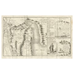
View AllAntique Map of the Red Sea
Basse Thebaide with Monastery Plans, Egypt, 1777
Located in Langweer, NL
Antique Map of the Red Sea & Basse Thebaide with Monastery Plans, Egypt, 1777
This finely detailed 18th-century engraving depicts the coastal and inland geography of the Red Sea reg...
Category
Antique Late 18th Century French Maps
Materials
Paper
Rare Sea Chart of the East Frisian Islands or Watten and the North Sea, c.1700
Located in Langweer, NL
Description: Antique map titled 'Paskaarte van de rievier de Elve streckende van Oldenbroek tot Hamburgh.'
Rare and interesting chart of the East Frisian Islands (or Watten) and th...
Category
Antique Early 1700s Dutch Maps
Materials
Paper
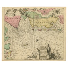
$1,553 Sale Price
30% Off
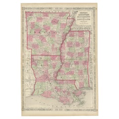
Rare 1864 Civil War Era Map of Arkansas, Mississippi, and Louisiana
Located in Langweer, NL
Title: Rare 1864 Civil War Era Map of Arkansas, Mississippi, and Louisiana
Description: This captivating antique map, titled "Johnson's Arkansas, Mississippi, and Louisiana," was pu...
Category
Antique 1860s Maps
Materials
Paper
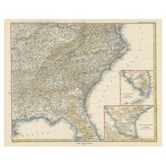
Antique Map of the Region of Georgia with Inset Maps of Florida and Texas
Located in Langweer, NL
Antique map of part of the United States showing Alabama, Georgia, North Carolina, South Carolina, Tennessee, Kentucky, Virginia and part of Florida. With inset maps of the southern ...
Category
Antique Late 19th Century Maps
Materials
Paper
$527 Sale Price
50% Off
Uncommon and Rare Map of the Caspian Sea by Order of the Czar, 1742
Located in Langweer, NL
Antique map, titled: 'Kaert van de Kaspische Zee volgens bevel van den Czaer (…).'
Uncommon map of Caspian Sea. Source unknown, to be determined.
Ar...
Category
Antique 1740s Maps
Materials
Paper
$700 Sale Price
20% Off
Steel Engraved Map of the United States with Inset Map of Florida
Located in Langweer, NL
Antique map titled 'United States'. Steel engraved map of the United States. With small inset map of the continuation of Florida. Source unknown, to be determined. Published circa 1843.
Category
Antique Mid-19th Century Maps
Materials
Paper
$153 Sale Price
20% Off
Still Thinking About These?
All Recently ViewedMore Ways To Browse
Sea Monster
Used Furniture Florida
Americana Antiques
Louisiana Furniture
Bahamas Furniture
Used Furniture Bahamas
18th Century Wood Side Tables
Antique Hand Carved Dining Room Sets
Mid Century Modern Pitcher
Vintage Italian Leather Dining Chair
Vintage Movie Posters
Blue Green Wool And Silk Rug
Brown Sheepskin Chair
Vintage Brass Bar Carts
Antique Botanical Prints
Green Persian Rug
17th Century Blue And White
50 X 50 Coffee Table