Items Similar to Map of Gard France with Pont du Gard and Wine Regions by Vuillemin, 19th c


Want more images or videos?
Request additional images or videos from the seller
1 of 10
Map of Gard France with Pont du Gard and Wine Regions by Vuillemin, 19th c
$166.95
£123.62
€140
CA$230.60
A$246.97
CHF 132.77
MX$2,999.59
NOK 1,677.60
SEK 1,535.97
DKK 1,066.98
About the Item
Title: Map of Gard France with Pont du Gard and Wine Regions by Vuillemin, 19th c
Description:
This finely engraved 19th-century map of the department of Gard in southern France was produced by Alexandre Vuillemin and published by Migeon in Paris as part of the *Nouvel Atlas Illustré*. The map blends detailed topographical information with artistic embellishments, offering a window into the geography, culture, and heritage of the region.
Gard is located in the Occitanie region and borders the Mediterranean Sea, Ardèche, Hérault, Bouches-du-Rhône, and Lozère. The map outlines the department with a fine hand-colored orange border and clearly marks towns, rivers, roadways, and topographic features. Nîmes, Uzès, Alès, and Beaucaire are among the many towns shown in detail.
At the lower left, a beautifully rendered vignette features the iconic **Pont du Gard**, a Roman aqueduct that stands as one of the most impressive and well-preserved Roman engineering feats in France. Built in the first century AD, it carried water to the city of Nîmes and remains a UNESCO World Heritage Site.
To the lower right, the map includes a portrait of **Jacques-Joseph de Gourbillon**, a local historical figure, with an unfurled map scroll and inscription. A coat of arms and botanical ornamentation add further decorative elements to the sheet.
Gard is also well known for its wine production, forming part of the greater **Côtes du Rhône** appellation. Vineyards near the Rhône River, including those around Tavel and Lirac, are especially notable. Tavel produces one of France’s most celebrated rosé wines, known for its full body, dry character, and historical reputation—it was said to be a favorite of Louis XIV and Ernest Hemingway. The department also produces reds and whites under the Costières de Nîmes and Duché d’Uzès AOCs, showcasing a blend of Mediterranean climate and Rhône varietals such as Syrah, Grenache, Mourvèdre, and Viognier.
Alexandre Vuillemin, a highly regarded French cartographer of the 19th century, was known for his clear yet decorative maps. His works with Migeon often included informative and picturesque features that made geography accessible and engaging to a broader audience.
Condition summary:
Very good condition with light age toning at the edges and a few minor foxing marks. The engraved detail remains sharp and the hand coloring is clean and well-preserved.
Framing tips:
Frame this map in a natural walnut or classic gold frame to enhance the historic charm. A warm ivory or pale terracotta mat will complement the orange border and Mediterranean tone of the subject. UV-protective glass is recommended for conservation.
- Dimensions:Height: 10.28 in (26.1 cm)Width: 12.8 in (32.5 cm)Depth: 0.01 in (0.2 mm)
- Materials and Techniques:Paper,Engraved
- Place of Origin:
- Period:
- Date of Manufacture:circa 1850
- Condition:Very good condition with light age toning at the edges and a few minor foxing marks. The engraved detail remains sharp and the hand coloring is clean and well-preserved.
- Seller Location:Langweer, NL
- Reference Number:Seller: BG-13331-291stDibs: LU3054345363922
About the Seller
5.0
Recognized Seller
These prestigious sellers are industry leaders and represent the highest echelon for item quality and design.
Platinum Seller
Premium sellers with a 4.7+ rating and 24-hour response times
Established in 2009
1stDibs seller since 2017
2,826 sales on 1stDibs
Typical response time: 1 hour
- ShippingRetrieving quote...Shipping from: Langweer, Netherlands
- Return Policy
More From This Seller
View AllMap of Allier France with Saint-Pourçain Wine Region by Vuillemin, 19th c
Located in Langweer, NL
Map of Allier France with Saint-Pourçain Wine Region by Vuillemin, 19th c
This decorative 19th-century map of Allier, a central department of France, comes from the celebrated Nouve...
Category
Antique Mid-19th Century French Maps
Materials
Paper

Map of Loire France with Saint-Étienne and Montbrison by Vuillemin, 19th c
Located in Langweer, NL
Map of Loire France with Saint-Étienne and Montbrison by Vuillemin, 19th c
This beautifully engraved and hand-colored map of the department of Loire in east-central France is from t...
Category
Antique Mid-19th Century French Maps
Materials
Paper

Map of Gers France with Auch and Armagnac Wine Region by Vuillemin, 19th c
Located in Langweer, NL
Map of Gers France with Auch and Armagnac Wine Region by Vuillemin, 19th c
This 19th-century engraved and hand-colored map of the department of Gers in southwestern France was creat...
Category
Antique Mid-19th Century French Maps
Materials
Paper

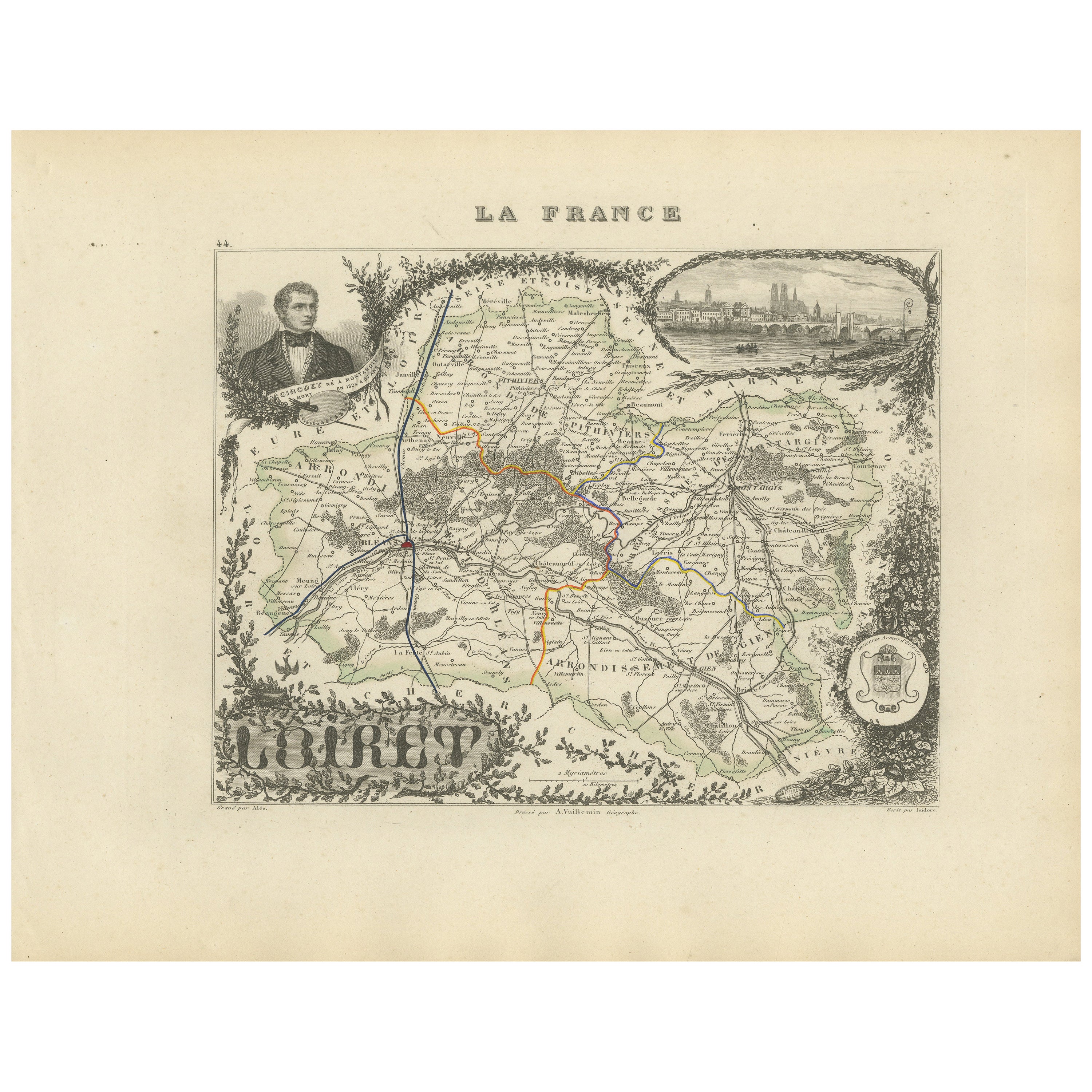
Map of Loiret France with Orléans and Loire River by Vuillemin, 19th c
Located in Langweer, NL
Map of Loiret France with Orléans and Loire River by Vuillemin, 19th c
This antique hand-colored map of the Loiret department, engraved by Alexandre Vuillemin and published by Migeo...
Category
Antique Mid-19th Century French Maps
Materials
Paper
Map of Côtes-du-Nord France with Saint-Brieuc and Brittany Coastline, c.1850
Located in Langweer, NL
Map of Côtes-du-Nord France with Saint-Brieuc and Brittany Coastline, 19th c
Description:
This elegant 19th-century map of Côtes-du-Nord, the historic name for what is now known as ...
Category
Antique Mid-19th Century French Maps
Materials
Paper

Map of Ain France with Vineyards of Bugey and Notable Portraits, c.1850
Located in Langweer, NL
Map of Ain France with Portraits of Bichat and Joubert by Vuillemin, 19th c
This highly decorative 19th-century map of the French department of Ain is taken from the celebrated Nouv...
Category
Antique Mid-19th Century French Maps
Materials
Paper

You May Also Like
Large 19th Century Map of France
Located in Pease pottage, West Sussex
Large 19th Century Map of France.
Remarkable condition, with a pleasing age worn patina.
Recently framed.
France Circa 1874.
Category
Antique Late 19th Century French Maps
Materials
Linen, Paper

Var, France. Antique map of a French department, 1856
By Victor Levasseur
Located in Melbourne, Victoria
'Dept. du Var', steel engraving with original outline hand-colouring., 1856, from Levasseur's Atlas National Illustre.
Var covers the heart of the French Riviera or Cote d'Azur., and includes the resort cities of Cannes, Nice and San Tropez...
Category
19th Century Naturalistic Landscape Prints
Materials
Engraving

Saone and Loire, France. Antique map of a French department, 1856
By Victor Levasseur
Located in Melbourne, Victoria
'Dept. de Saone et Loire', steel engraving with original outline hand-colouring., 1856, from Levasseur's Atlas National Illustre.
The French department of Saone et Loire is at the ...
Category
19th Century Naturalistic Landscape Prints
Materials
Engraving

Aude, France. Antique map of a French department, 1856
By Victor Levasseur
Located in Melbourne, Victoria
'Dept. de L' Aude', steel engraving with original outline hand-colouring., 1856, from Levasseur's 'Atlas National Illustre'.
This area of France is famous for its wide variety of v...
Category
19th Century Naturalistic Landscape Prints
Materials
Engraving

France, Northern Part. Century Atlas antique map
Located in Melbourne, Victoria
'The Century Atlas. France, Northern Part.'
Original antique map, 1903.
Inset maps of 'France in Provinces' and 'Paris and Vicinity'.
Central fold as issued. Map name and number pr...
Category
Early 20th Century Victorian More Prints
Materials
Lithograph

Map of France - Etching - 1820
Located in Roma, IT
Map of France is an Original Etching realized by an unknown artist of 19th century in 1820.
Very good condition on two sheets of white paper joined at t...
Category
1820s Modern Figurative Prints
Materials
Etching

More Ways To Browse
Antique Aly
Red And Gold Wine Glasses
Wine Map
French Wine Map
Scroll Map
Paisley Rugs and Carpets
Black And Chrome Lounge Chair
Vintage 1930 Dining Room Set
Antique Victorian Dining Tables
Environment Furniture
Italian Plastic Chairs
Made In Belgium
Black Crystal Glasses
French Mid Century Modern Rug
China Silk Rug
Chrome Glass Coffee Tables
Antique Italian Chairs
Antique Walnut Bar