Items Similar to Map of Guyane (French Guiana) with Cayenne, circa 1826
Want more images or videos?
Request additional images or videos from the seller
1 of 10
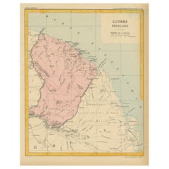
Map of Guyane (French Guiana) with Cayenne, circa 1826
$190.80
£141.28
€160
CA$263.54
A$282.25
CHF 151.74
MX$3,428.11
NOK 1,917.26
SEK 1,755.40
DKK 1,219.40
About the Item
Map of Guyane (French Guiana) with Cayenne, circa 1826
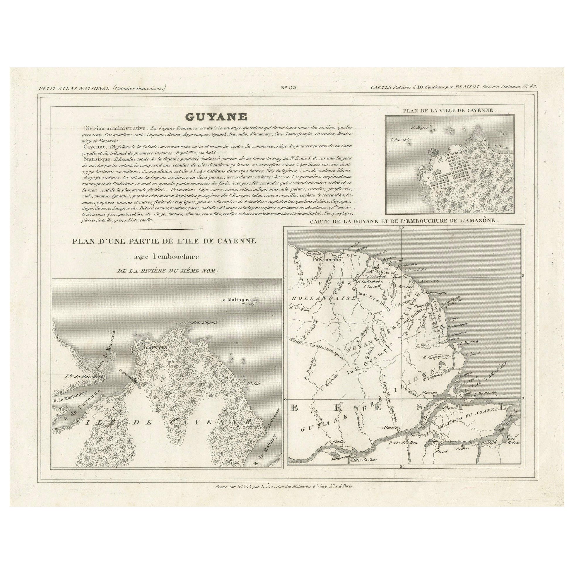
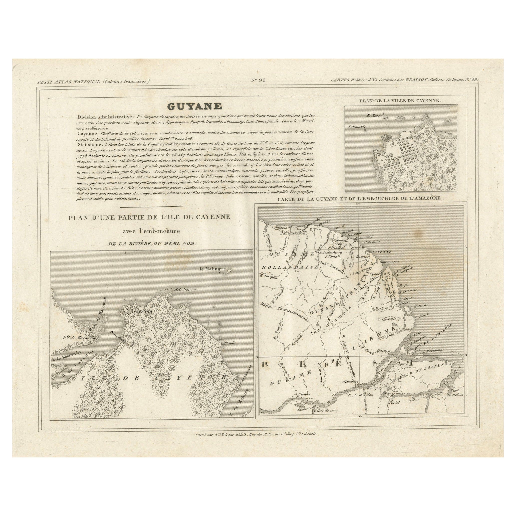
This is an antique French map titled “Guyane” from *Petit Atlas National (Colonies françaises)* published by Blaisot around 1826. It features three distinct cartographic elements:
1. Main map – Carte de la Guyane et de l'embouchure de l'Amazone: showing the northern coast of South America including French Guiana, Dutch Guiana (Suriname), and the Amazon River mouth in Brazil, with detailed river systems, settlements, and borders.
2. Inset city plan – Plan de la ville de Cayenne: a finely engraved small city plan depicting the fortifications, street grid, and coastal layout of Cayenne city, the colonial capital.
3. Inset island plan – Plan d'une partie de l'île de Cayenne avec l'embouchure de la rivière du même nom: showing the island of Cayenne with rivers, vegetation areas, and geographical detail, useful for colonial administration and navigation.
Above the maps is a comprehensive text block describing administrative divisions, population statistics, geography, and economic data of French Guiana during the early 19th century.
Engraved by M. Aubry, Rue des Mathurins St. Jacques No. 5, Paris.
Condition:
Fair condition with strong impression. General age toning, scattered light foxing in blank margins. Paper edges with minor handling marks consistent with age.
Framing suggestions:
Frame floated in a slim black, walnut, or gold leaf frame with a soft cream archival mat to highlight its historic engravings and French colonial typography. Ideal for display in a study, library, or a travel-themed gallery wall.
Keywords:
French Guiana map, antique map Cayenne, Blaisot Petit Atlas National, South America colonial map, Amazon River map, French colonies, Suriname, Guyana, 19th century engraved map, historic cartography, Paris engravings
- Dimensions:Height: 8.67 in (22 cm)Width: 11.82 in (30 cm)Depth: 0.01 in (0.2 mm)
- Materials and Techniques:Paper,Engraved
- Place of Origin:
- Period:
- Date of Manufacture:1826
- Condition:Fair condition with strong impression. General age toning, scattered light foxing in blank margins. Paper edges with minor handling marks consistent with age.
- Seller Location:Langweer, NL
- Reference Number:Seller: BG-13093-271stDibs: LU3054345747762
About the Seller
5.0
Recognized Seller
These prestigious sellers are industry leaders and represent the highest echelon for item quality and design.
Platinum Seller
Premium sellers with a 4.7+ rating and 24-hour response times
Established in 2009
1stDibs seller since 2017
2,826 sales on 1stDibs
Typical response time: 1 hour
- ShippingRetrieving quote...Shipping from: Langweer, Netherlands
- Return Policy
More From This Seller
View AllMap of French Guiana, Suriname and Cayenne: Plan from Petit Atlas National, 1820
Located in Langweer, NL
This map, titled "Guyane" (French Guiana), is part of the Petit Atlas National series, focusing on French colonies. Here are the key elements of the map and its context:
Features:
-...
Category
Antique 1820s Maps
Materials
Paper

$152 Sale Price
20% Off
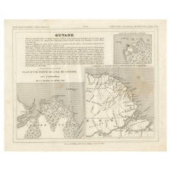
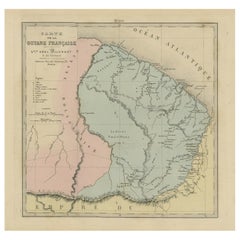
Antique Map of French Guiana and Cayenne – Circa 1835
Located in Langweer, NL
Antique Map of French Guiana and Cayenne – Circa 1835
This rare 19th-century map of French Guiana, published around 1835, provides a detailed overview of the region, including the...
Category
Antique 1830s Maps
Materials
Paper
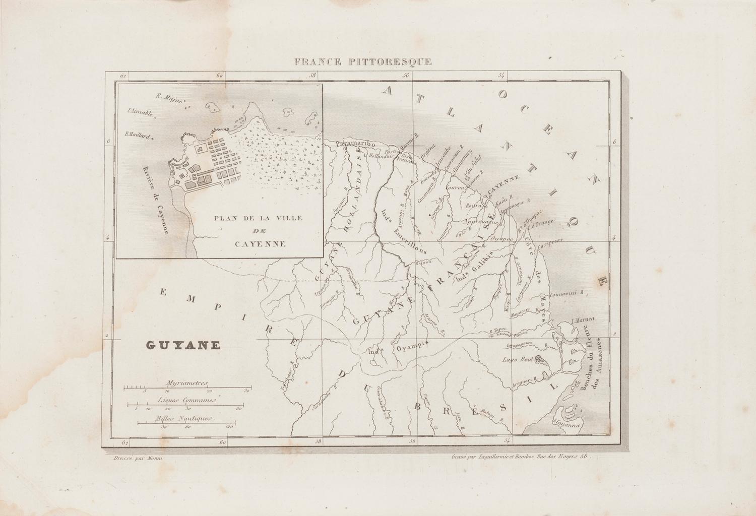
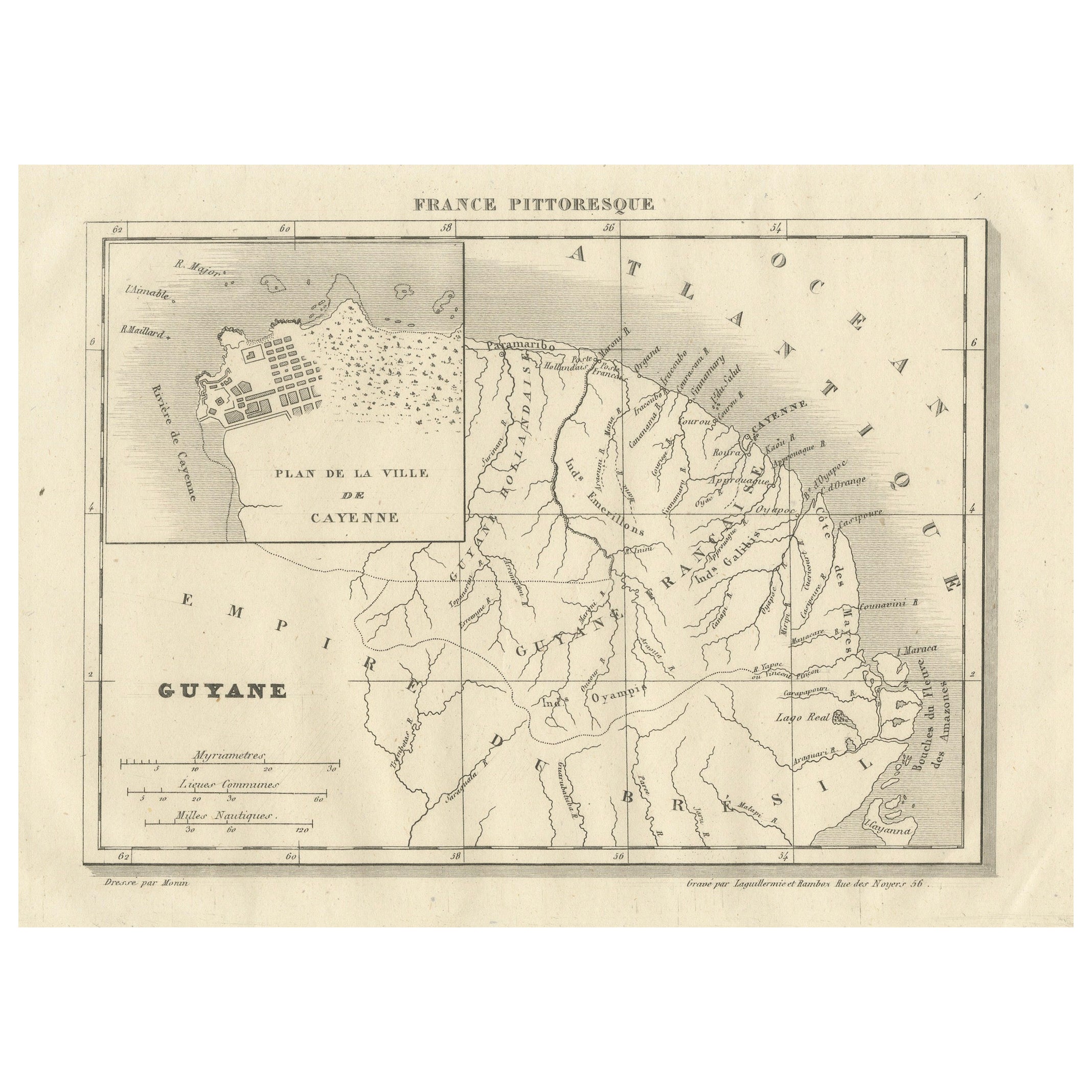
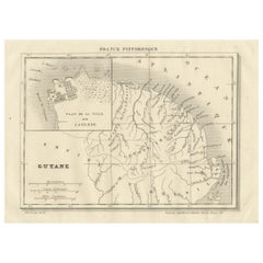
French Guiana and Cayenne: Mid-19th Century Map from France Pittoresque Series
Located in Langweer, NL
This map titled "Guyane" is part of the France Pittoresque series and provides a detailed view of French Guiana along with a plan of the city of Cayenne.
Features:
- The map showcases the broader region of French Guiana, indicating key rivers, settlements, and the coastline along the Atlantic Ocean.
- To the left, there's an inset labeled "Plan de la Ville de Cayenne", which shows the street layout, squares, and main buildings of the capital city, Cayenne. This inset provides a more detailed view of the urban area, highlighting its geometric grid layout near the coast.
- The larger map outlines geographical features such as rivers (e.g., Oyapock and Maroni), forests, and territories in the surrounding area, including the neighboring Brazilian Empire...
Category
Antique 1850s Maps
Materials
Paper
$114 Sale Price
20% Off
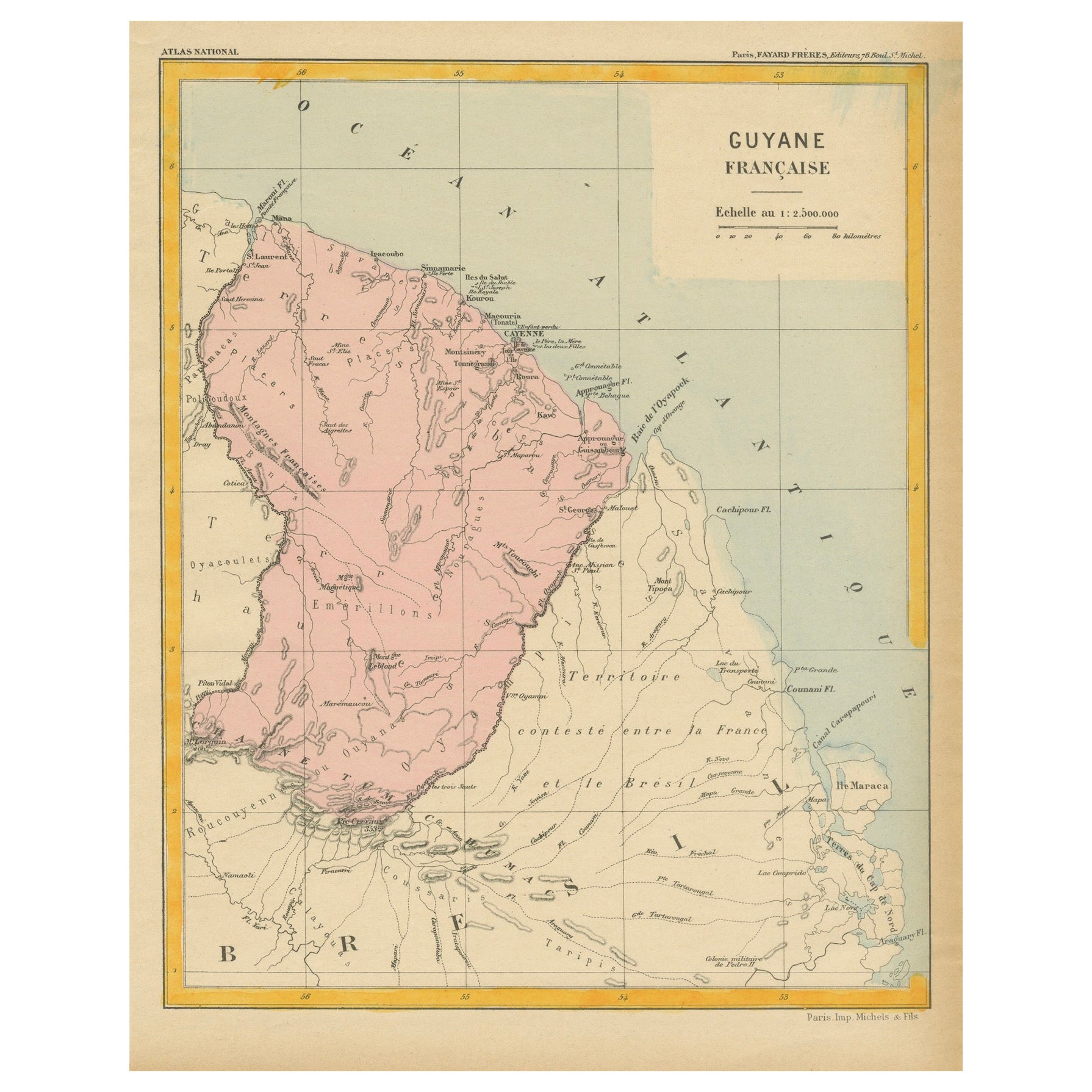
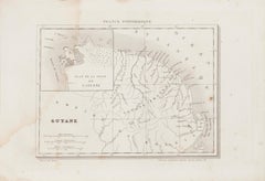
Map of French Guiana: 19th Century Atlas National Depiction of Guyane Française
Located in Langweer, NL
The map is titled "Guyane Française" (French Guiana) and is part of the Atlas National series. Here are the key details:
Features:
- The map focuses on French Guiana, a French overs...
Category
Antique 1890s Maps
Materials
Paper
$114 Sale Price
20% Off
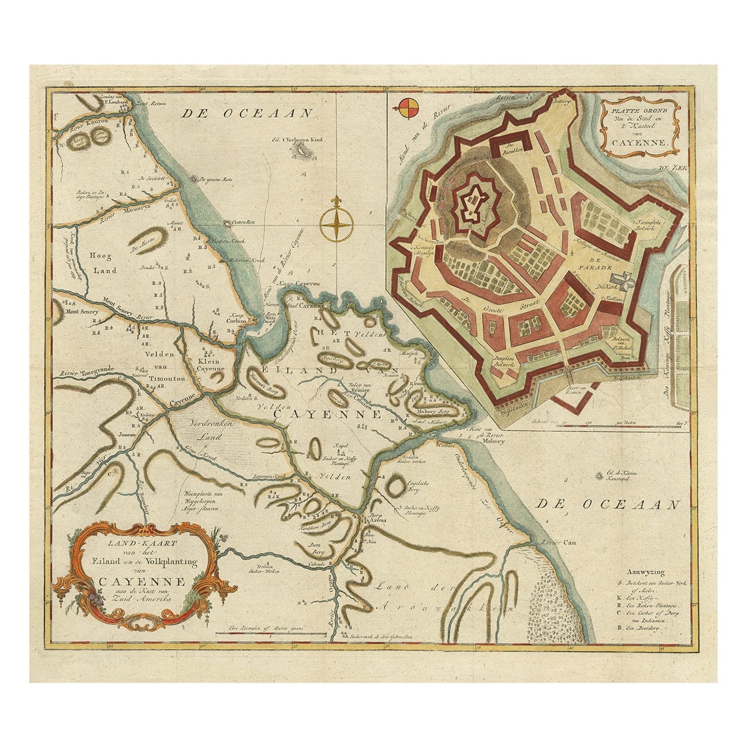
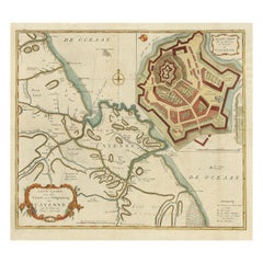
Striking Antique Map of Cayenne in French Guyana, South America, ca.1760
Located in Langweer, NL
Description: Antique map titled 'Land-kaart van het Eiland en de Volkplanting van Cayenne aan de Kust van Zuid-Amerika'.
Striking map of the island and settlement of Cayenne in F...
Category
Antique 1760s Maps
Materials
Paper
Antique Engraved Map with Original Hand Colour of French Guiana, 1876
Located in Langweer, NL
The 1876 map of French Guiana from the "Grand Atlas Départemental de la France de L'Algérie et des colonies" by H. Fisquet, published by A. Le Vasseur in Paris, is a significant piec...
Category
Antique Late 19th Century Maps
Materials
Paper
$267 Sale Price
20% Off
You May Also Like
Ancient Map of Guyane - Original Etching - 19th Century
Located in Roma, IT
Map of Guyane is an original etching realized by an anonymous engraver of the 19th Century.
Belongs to the Series of "France Pittoresque" at the top center.
The state of preservati...
Category
19th Century Modern Figurative Prints
Materials
Etching
Map Colonies Francaises Martinique, 1845
Located in BUNGAY, SUFFOLK
Colonies Francaises, Martinique, Amerique DU SUD
Geographie et Statistique par V.Levasseur. Ing'r Geographe.
Illustre par Raymond Bonheur, peintre.
Grave par Laguihermie, Rue St...
Category
Antique 19th Century French Maps
Materials
Paper

Map Of Martinique - Etching - 19th Century
Located in Roma, IT
Map Of Martinique is an etching realized by an anonymous engraver of the 19th Century.
Printed within the series "France Pittoresque" at the top center.
The state of preservation o...
Category
19th Century Modern Figurative Prints
Materials
Etching

Map Of The Island Of Cuba - Guillaume Thomas Raynal (1711-1796)
Located in Porto, PT
This historical map of the Island of Cuba was produced in the late 18th century and is taken from an edition of “Atlas de toutes les parties connues du globe terrestre” by the French...
Category
Antique 18th Century Prints
Materials
Glass, Paper

West Coast of Africa; Guinea
Sierra Leone: Bellin 18th Century Map
Located in Alamo, CA
This is a Jacques Bellin copper-plate map entitled "Partie de la Coste de Guinee Dupuis la Riviere de Sierra Leona Jusquau Cap das Palmas", depicting the coast of Guinea and Sierra L...
Category
1740s Old Masters Landscape Prints
Materials
Engraving

West Africa Entitled "Guinea Propria": An 18th Century Hand Colored Homann Map
By Johann Baptist Homann
Located in Alamo, CA
This is a scarce richly hand colored copper plate engraved map of Africa entitled "Guinea Propria, nec non Nigritiae vel Terrae Nigrorum Maxima Pars" by Johann Baptist Homann (1664-1...
Category
Antique Mid-18th Century German Maps
Materials
Paper

More Ways To Browse
Amazon With
China Silk Rug
Chrome Glass Coffee Tables
Antique Italian Chairs
Beni Ourain Rugs
French Iron And Glass Table
Glass Top Wood Base Coffee Tables
T Chair
Antique Silver Basket
Antique Walkers
Ebony Wood Furniture
Opalescent Glass
Pair Of Danish Chairs
Veneer Dining Tables
1970 Italian Armchair
Furniture Uk
House Of Denmark Table And Chairs
Louis Marble Top Side Table