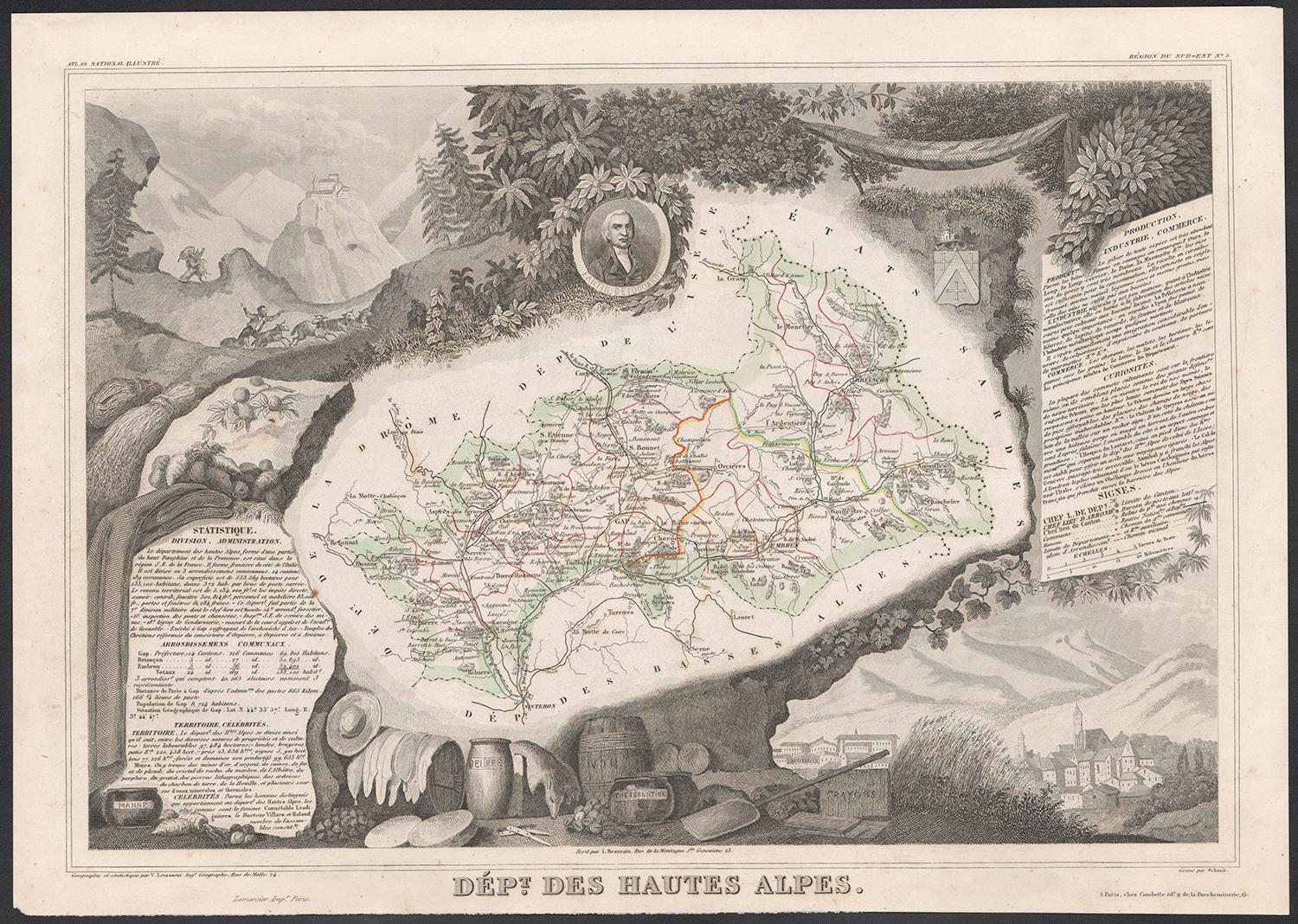
Items Similar to Map of Hautes-Alpes France with Gap and Alpine Scenery by Vuillemin, c.1850
Want more images or videos?
Request additional images or videos from the seller
1 of 10
Map of Hautes-Alpes France with Gap and Alpine Scenery by Vuillemin, c.1850
$143.99
£106.71
€120
CA$196.80
A$214.23
CHF 113.71
MX$2,577.67
NOK 1,440.91
SEK 1,320.28
DKK 914.08
About the Item
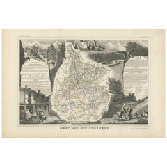
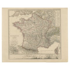
Map of Hautes-Alpes France with Gap and Alpine Scenery by Vuillemin
Description:
This elegant 19th-century map of the Hautes-Alpes department in southeastern France was created by Alexandre Vuillemin and published by Migeon in Paris as part of the richly illustrated Nouvel Atlas Illustré. The map presents a detailed view of this mountainous region, framed by artistic engravings that highlight its historical, topographical, and cultural significance.
Hautes-Alpes is one of the highest and most sparsely populated departments in France, located in the heart of the French Alps. The map is bordered with a soft hand-colored blue to indicate the departmental boundary. Towns, roads, and rivers are carefully engraved, and the mountainous terrain is subtly rendered with engraved shading. The map offers a close view of the towns of Gap, Embrun, Briançon, and the surrounding alpine passes that have long connected France and Italy.
At the upper left, a portrait of the Duc de Lesdiguières is featured. He was a key military leader in the Wars of Religion and the last Constable of France, born in the region and associated with its defense and development. In the upper right, a coat of arms appears with a fortified tower motif. The lower half of the sheet is dominated by an engraved vignette of Gap, the department’s prefecture, nestled in an idyllic alpine valley. Trees, livestock, and cottages contribute to the rural and peaceful atmosphere that characterizes this high-altitude area.
Though Hautes-Alpes is not a major wine-producing region due to its elevation and climate, it is known for small-scale, high-altitude viticulture in valleys such as those around Embrun and Tallard. More than its wine, however, the area is celebrated for winter sports, mountain tourism, and its stunning natural scenery. Hiking, skiing, and nature excursions are key to the region’s identity.
Alexandre Vuillemin was known for his skill in producing maps that were both accurate and decorative. His publisher, Migeon, brought these works to a wide audience through visually engaging atlases, combining educational and artistic appeal.
Condition summary:
Very good antique condition with only minor age-related foxing in the margins. Original hand-coloring is well preserved, and all engraved lines remain crisp and clear.
Framing tips:
This map would suit a natural wood frame or one with a distressed alpine finish. A cream or pale blue mat will complement the hand-colored border and evoke the cool tones of the mountain setting. Museum-quality glass is recommended for protection.
- Dimensions:Height: 10.28 in (26.1 cm)Width: 12.8 in (32.5 cm)Depth: 0.01 in (0.2 mm)
- Materials and Techniques:Paper,Engraved
- Place of Origin:
- Period:
- Date of Manufacture:circa 1850
- Condition:Very good antique condition with only minor age-related foxing in the margins. Original hand-coloring is well preserved, and all engraved lines remain crisp and clear.
- Seller Location:Langweer, NL
- Reference Number:Seller: BG-13331-51stDibs: LU3054345359152
About the Seller
5.0
Recognized Seller
These prestigious sellers are industry leaders and represent the highest echelon for item quality and design.
Platinum Seller
Premium sellers with a 4.7+ rating and 24-hour response times
Established in 2009
1stDibs seller since 2017
2,816 sales on 1stDibs
Typical response time: 1 hour
- ShippingRetrieving quote...Shipping from: Langweer, Netherlands
- Return Policy
More From This Seller
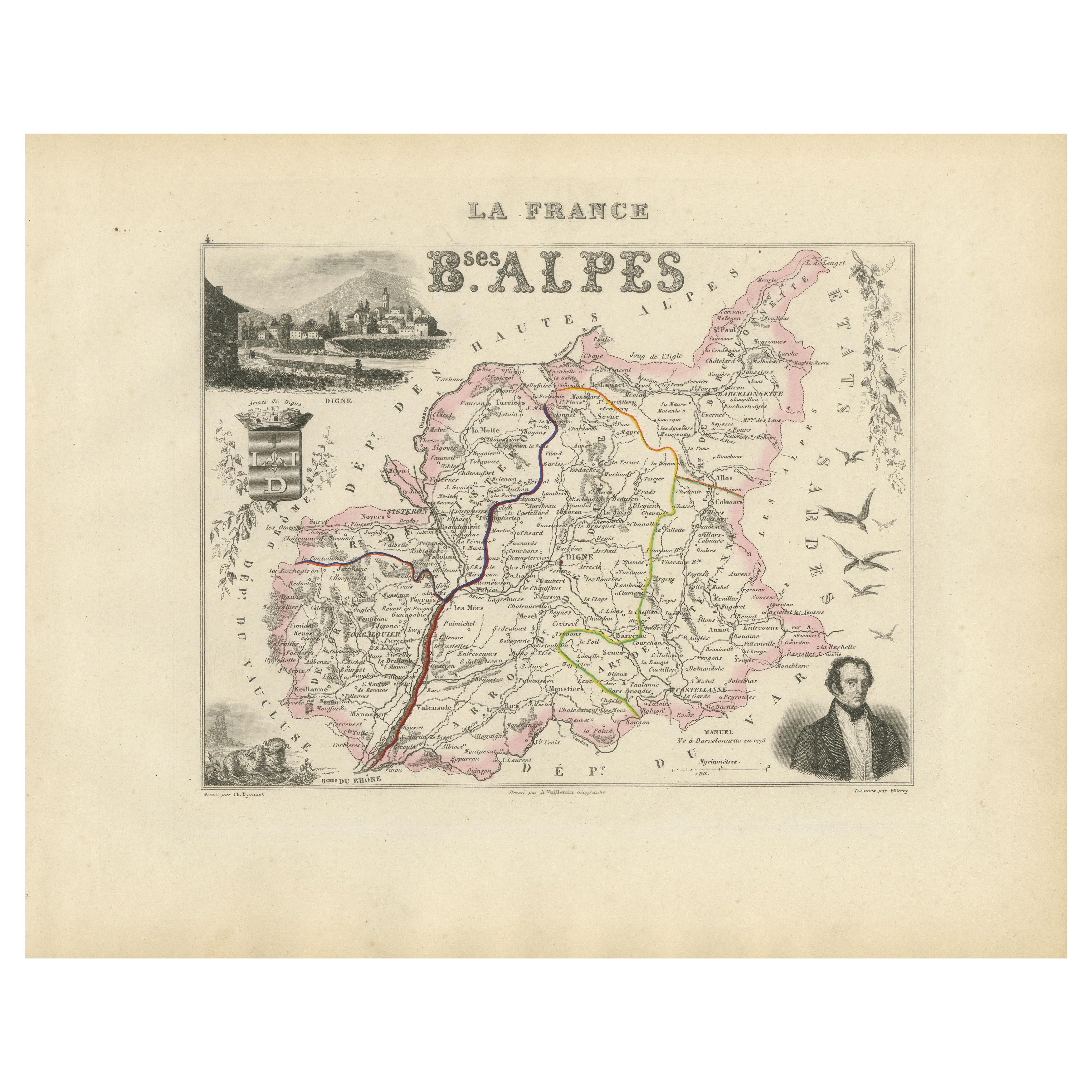
View AllMap of Basses-Alpes France with Digne and Lavender Region by Vuillemin, c.1850
Located in Langweer, NL
Map of Basses-Alpes France with Digne and Lavender Region by Vuillemin, 19th c
This finely engraved 19th-century map of the Basses-Alpes department of France (known today as Alpes-d...
Category
Antique Mid-19th Century French Maps
Materials
Paper
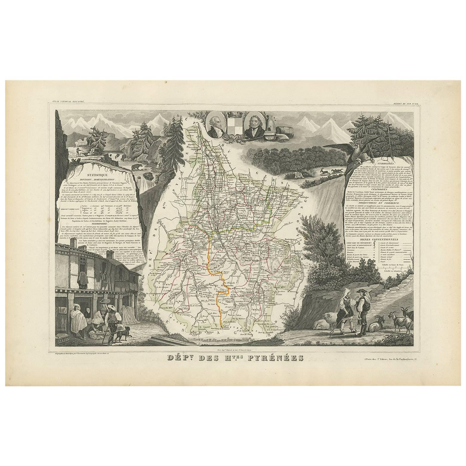
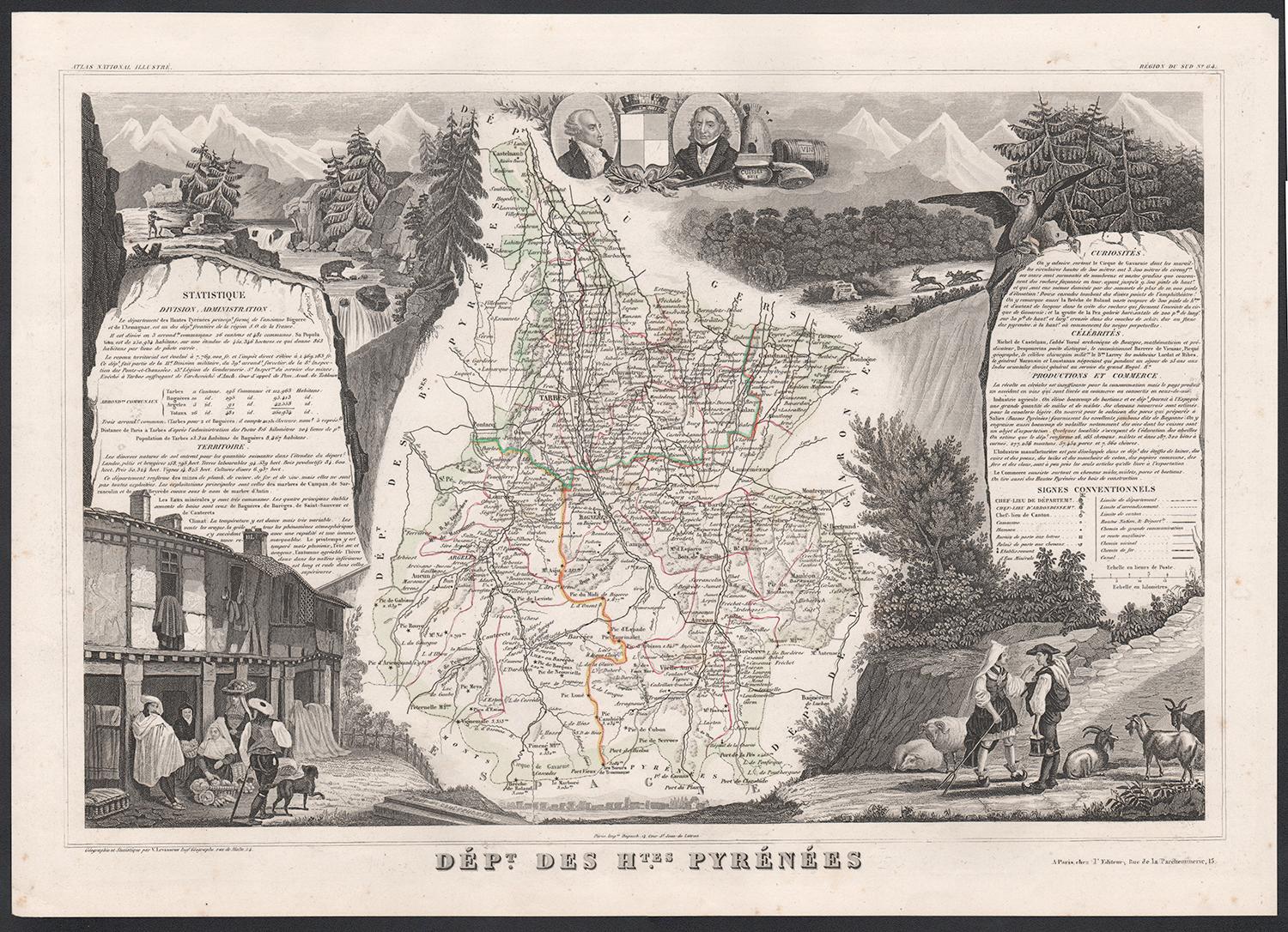
Antique Map of the Hautes Pyrenees
France
by V. Levasseur, 1854
By Victor Levasseur
Located in Langweer, NL
Antique map titled 'Dépt. des Htes. Pyrénées'. Map of the French department of Hautes Pyrenees, France. This area is home to the wine producing region, Madiran. Madrian is best known...
Category
Antique Mid-19th Century Maps
Materials
Paper
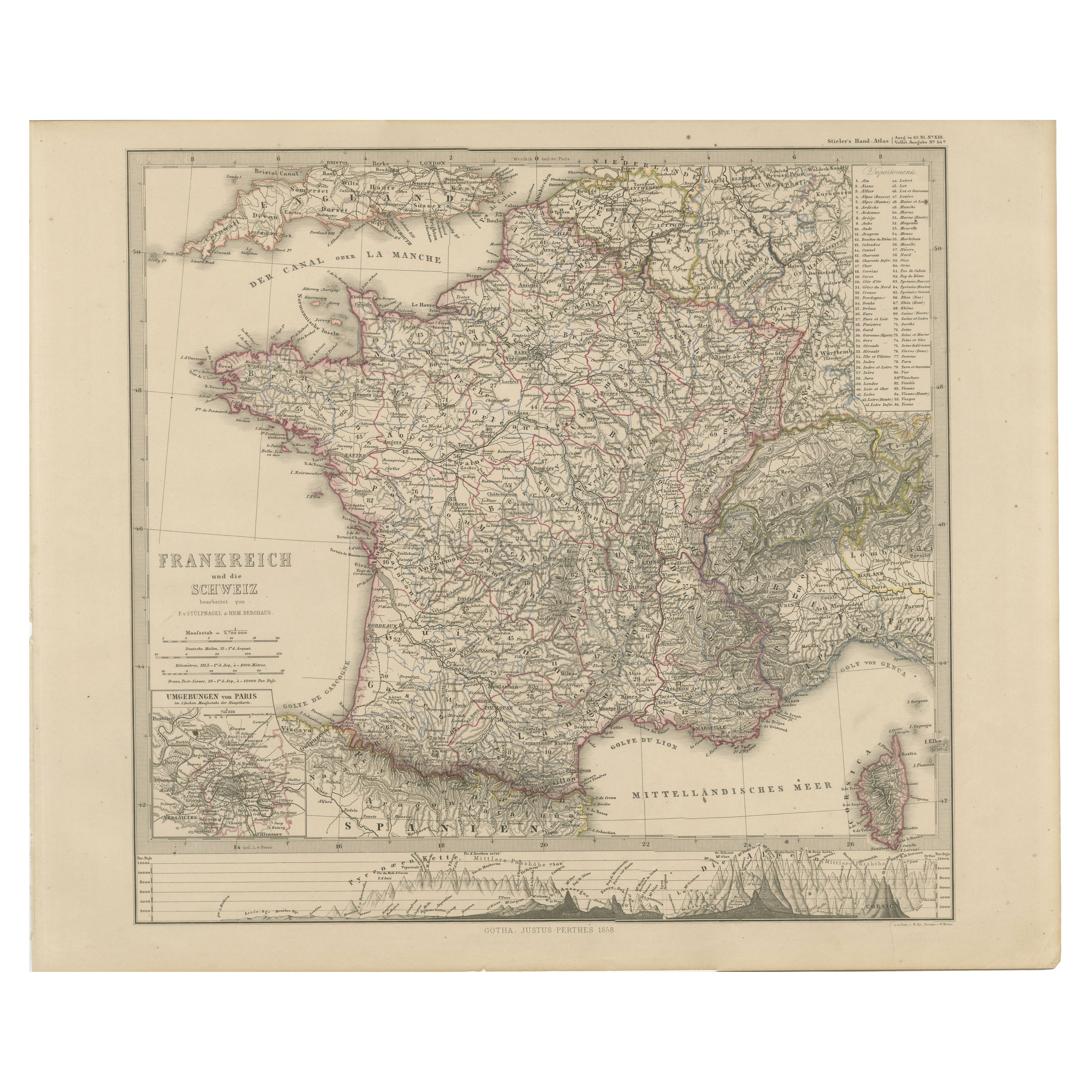
1856 France and Switzerland Map with Mountain Profiles
Located in Langweer, NL
1856 Map of France and Switzerland with Paris Inset by Stülpnagel
This finely detailed antique map of France and Switzerland was published in 1856 by the esteemed German cartographe...
Category
Antique Mid-19th Century German Maps
Materials
Paper
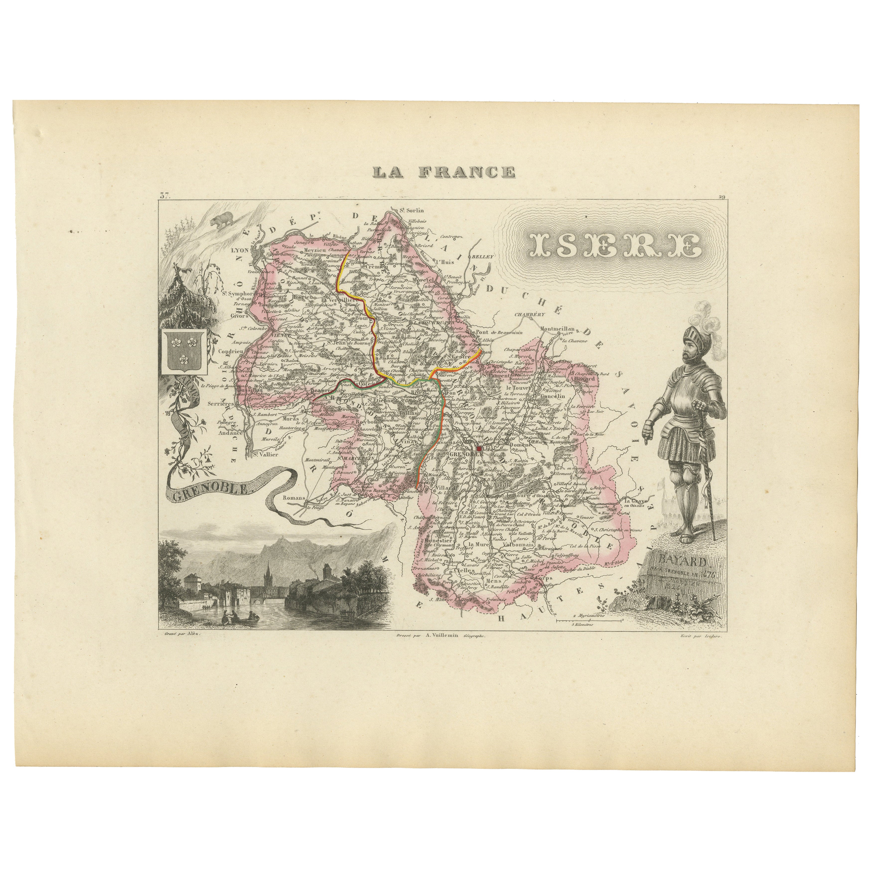
Antique French Map of Isère Region with Grenoble, Vienne, Dauphiné, 1800s
Located in Langweer, NL
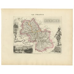
Antique Map of Isère, France by Vuillemin, 19th Century
This decorative 19th-century map presents the département of Isère in southeastern France, engraved by Alexandre Vuillemin. C...
Category
Antique Mid-19th Century French Maps
Materials
Paper
Map of Allier France with Saint-Pourçain Wine Region by Vuillemin, 19th c
Located in Langweer, NL
Map of Allier France with Saint-Pourçain Wine Region by Vuillemin, 19th c
This decorative 19th-century map of Allier, a central department of France, comes from the celebrated Nouve...
Category
Antique Mid-19th Century French Maps
Materials
Paper

Map of Loire France with Saint-Étienne and Montbrison by Vuillemin, 19th c
Located in Langweer, NL
Map of Loire France with Saint-Étienne and Montbrison by Vuillemin, 19th c
This beautifully engraved and hand-colored map of the department of Loire in east-central France is from t...
Category
Antique Mid-19th Century French Maps
Materials
Paper

You May Also Like
Hautes Alpes, France. Antique map of a French department, 1856
By Victor Levasseur
Located in Melbourne, Victoria
'Dept. des Hautes Alpes', steel engraving with original outline hand-colouring., 1856, from Levasseur's 'Atlas National Illustre'.
This area of France i...
Category
19th Century Naturalistic Landscape Prints
Materials
Engraving

Hautes Pyrenees, France. Antique map of a French department, 1856
By Victor Levasseur
Located in Melbourne, Victoria
'Dept. des Hautes Pyrenees', steel engraving with original outline hand-colouring., 1856, from Levasseur's Atlas National Illustre.
This area is home to the wine producing region, ...
Category
19th Century Naturalistic Landscape Prints
Materials
Engraving

Hautes-Pyrénées Map - Original Lithograph - 19th Century
Located in Roma, IT
Hautes-Pyrénées Map is an original lithograph realized by an Anonymous engraver of the 19th Century.
Printed in series of "France Pittoresque" at the top center.
The state of prese...
Category
19th Century Modern Figurative Prints
Materials
Paper, Lithograph

Pyrenees Orientales, France. Antique map of a French department, 1856
By Victor Levasseur
Located in Melbourne, Victoria
'Dept. des Pyrenees Orientales', steel engraving with original outline hand-colouring., 1856, from Levasseur's 'Atlas National Illustre'.
This area is well-known wine producing reg...
Category
19th Century Naturalistic Landscape Prints
Materials
Engraving

Fine Antique 1856 Hand Watercolour Map of Dept Des Hautes Alpes by Levasseur
s
Located in West Sussex, Pulborough
We are delighted to offer for sale this stunning 1856 hand watercolour map of the Austrian Alps titled Dept Des Hautes Alpes taken from the Atlas National...
Category
Antique 1850s French Early Victorian Maps
Materials
Paper

Lozere, France. Antique map of a French department, 1856
By Victor Levasseur
Located in Melbourne, Victoria
'Dept. de La Lozere', steel engraving with original outline hand-colouring., 1856, from Levasseur's 'Atlas National Illustre'.
This remote mountainous part of Languedoc is rural, s...
Category
19th Century Naturalistic Landscape Prints
Materials
Engraving

More Ways To Browse
Antique French Heart
Antique Alpine Furniture
Alpes Furniture
Paisley Rugs and Carpets
Black And Chrome Lounge Chair
Vintage 1930 Dining Room Set
Antique Victorian Dining Tables
Environment Furniture
Italian Plastic Chairs
Made In Belgium
Black Crystal Glasses
French Mid Century Modern Rug
China Silk Rug
Chrome Glass Coffee Tables
Antique Italian Chairs
Antique Walnut Bar
Beni Ourain Rugs
French Iron And Glass Table