Items Similar to Map of Italy and Neighboring Regions by Delamarche – Antique Map, c.1800

Video Loading
Want more images or videos?
Request additional images or videos from the seller
1 of 11
Map of Italy and Neighboring Regions by Delamarche – Antique Map, c.1800
$679.73
£503.31
€570
CA$938.86
A$1,005.52
CHF 540.56
MX$12,212.63
NOK 6,830.25
SEK 6,253.60
DKK 4,344.12
About the Item
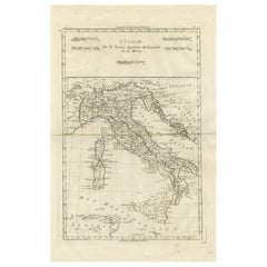
Antique Map of Italy and Surrounding Regions by Delamarche, circa 1800
This elegant and detailed antique map titled Carte Générale de l’Italie was drawn and engraved by the French geographer Charles-François Delamarche around 1800. Based on astronomical observations and the latest geographic measurements of the time, the map reflects the advanced cartographic knowledge of the early 19th century. It was published in Paris during the period of the French Republic, and it offers an accurate and comprehensive view of Italy and its neighboring regions.
The map shows the entire Italian peninsula, including the islands of Sicily, Sardinia, and Corsica, as well as parts of France, Switzerland, Dalmatia (modern-day Croatia), and North Africa. It highlights major cities such as Rome, Naples, Florence, Venice, Milan, Palermo, and Turin, and includes regional boundaries, mountain ranges, and river systems. The Adriatic and Tyrrhenian Seas, as well as the Gulf of Venice and the Mediterranean Sea, are clearly labeled. A delicately engraved compass rose and scale bar in the lower right enhance the map’s utility and aesthetic appeal.
The cartouche in the upper right corner attributes the map to Delamarche, who succeeded Robert de Vaugondy as royal geographer and was known for updating and improving existing geographic works with scientific precision. This map reflects the French Enlightenment tradition of empirical accuracy and visual clarity.
Drawn during a period of significant political transformation in Europe, including Napoleon’s campaigns in Italy, the map also serves as a historical document of geopolitical interest, marking boundaries and territories just before the unification of Italy later in the 19th century.
Condition:
The map is in good condition for its age. It shows original folds as issued and some slight toning and small marginal tears typical of antique maps from this period. The engraved lines are sharp and the hand-colored outlines of regional borders remain clean and vibrant. There is some light spotting along the edges, but nothing that affects the printed area.
Framing suggestion:
This map would display beautifully in a classic black or dark wood frame with a neutral mat in ivory or soft grey. UV-protective glass is recommended to preserve the integrity of the paper and coloring. A horizontal frame orientation suits the wide format of the composition, making it ideal for office, library, or study wall decor.
- Dimensions:Height: 22.45 in (57 cm)Width: 31.7 in (80.5 cm)Depth: 0.01 in (0.2 mm)
- Materials and Techniques:Paper,Engraved
- Place of Origin:
- Period:
- Date of Manufacture:1800
- Condition:The map is in good condition for its age. It shows original folds as issued and some slight toning and small marginal tears typical of antique maps from this period. The engraved lines are sharp. Some light spotting along the edges.
- Seller Location:Langweer, NL
- Reference Number:Seller: BG-13769-421stDibs: LU3054345616692
About the Seller
5.0
Recognized Seller
These prestigious sellers are industry leaders and represent the highest echelon for item quality and design.
Platinum Seller
Premium sellers with a 4.7+ rating and 24-hour response times
Established in 2009
1stDibs seller since 2017
2,826 sales on 1stDibs
Typical response time: 1 hour
- ShippingRetrieving quote...Shipping from: Langweer, Netherlands
- Return Policy
More From This Seller
View AllAntique Map of Italy by Keizer
de Lat, 1788
Located in Langweer, NL
Antique map titled 'Kaart van Italie (..)'. Uncommon original antique map of Italy. This map originates from 'Nieuwe Natuur- Geschied- en Handelk...
Category
Antique Late 18th Century Maps
Materials
Paper

$312 Sale Price
25% Off
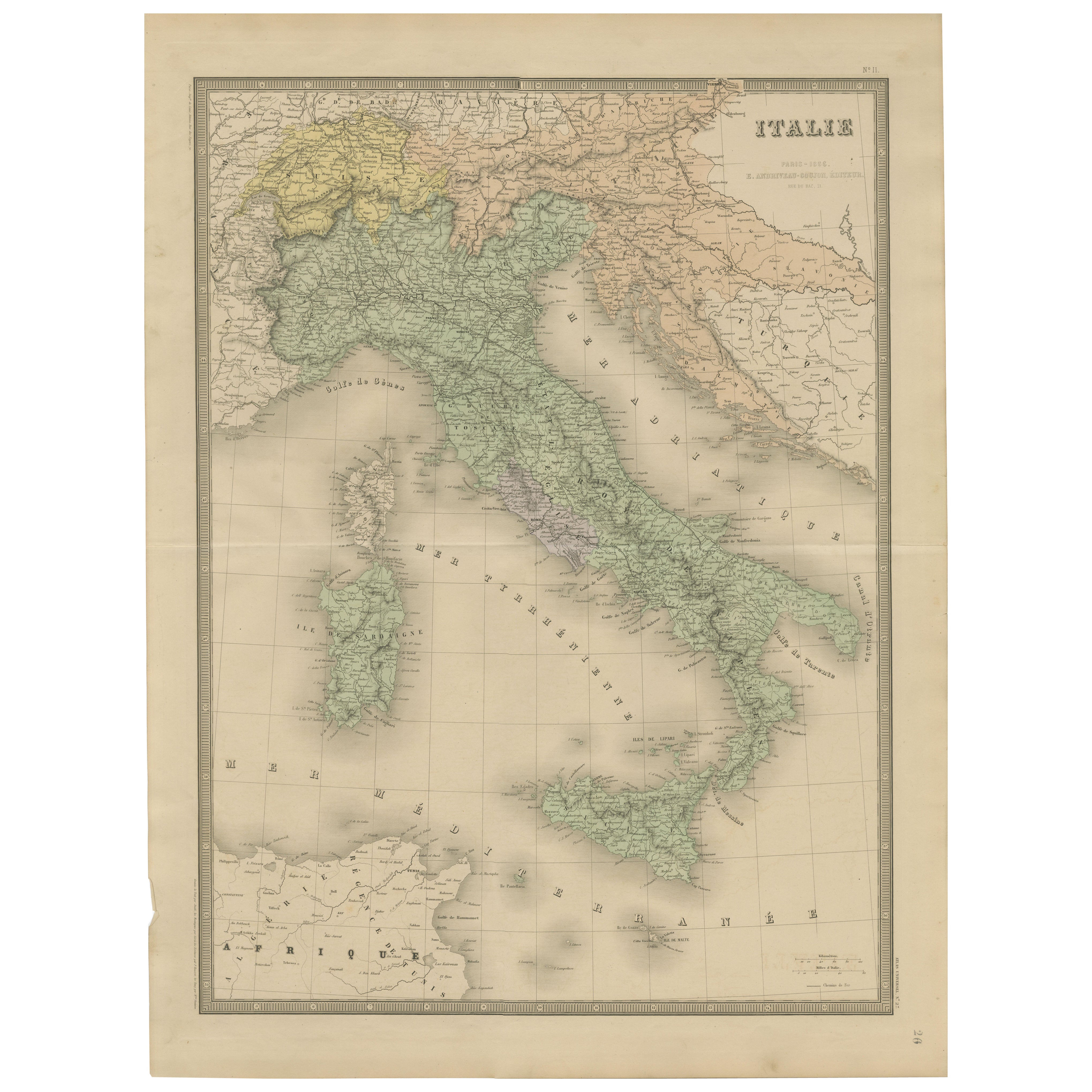
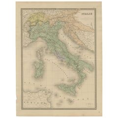
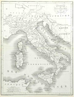
Antique Map of Italy – Pre-Unification Italy by Andriveau-Goujon, Paris 1861
Located in Langweer, NL
Antique Map of Italy – Pre-Unification Italy by Andriveau-Goujon, Paris 1861
This antique map of Italy, titled simply “Italie,” was published in Paris in 1861 by E. Andriveau-Goujon...
Category
Antique Mid-19th Century French Maps
Materials
Paper
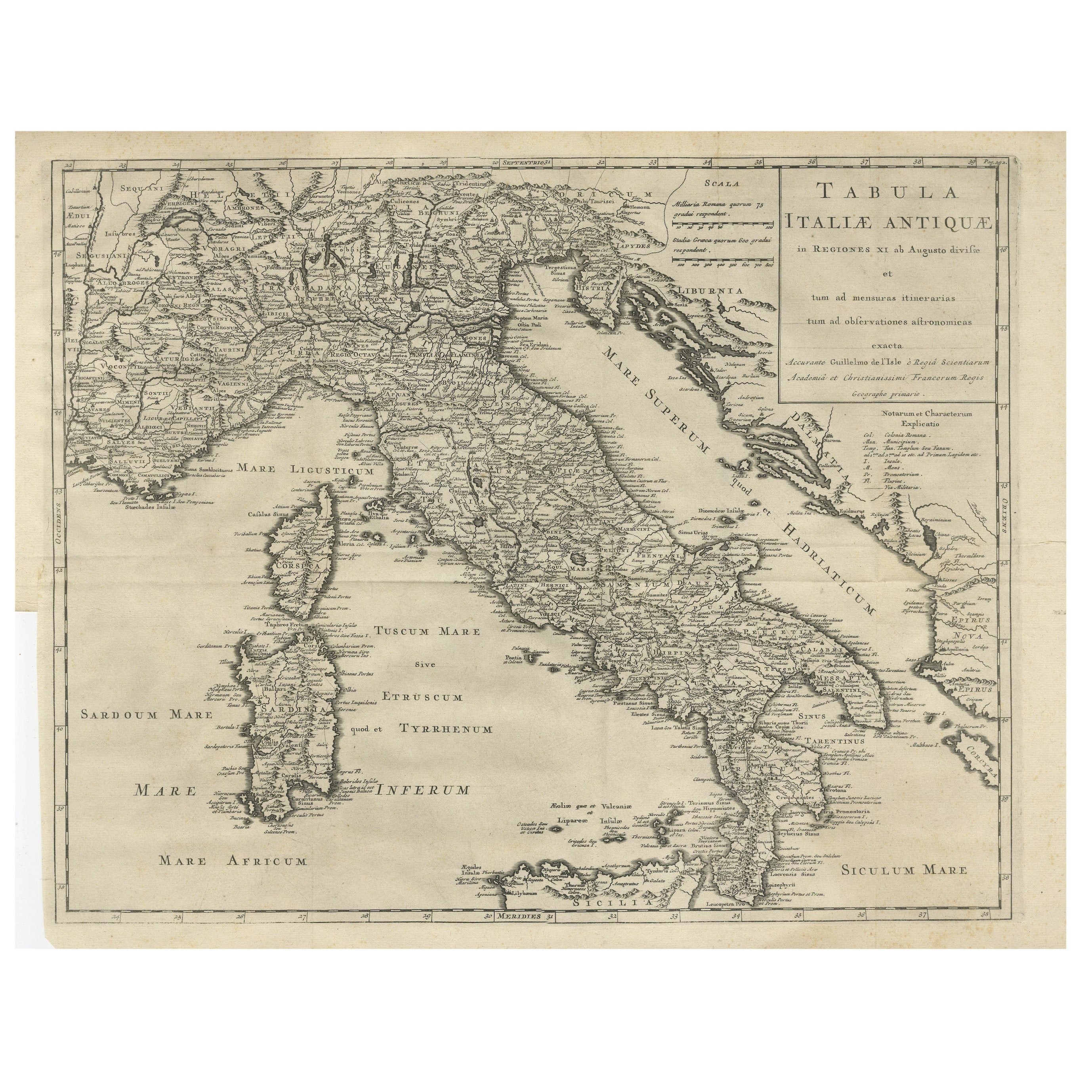
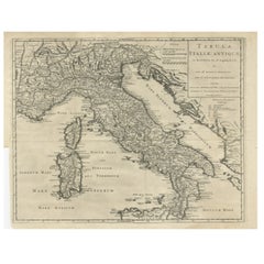
Antique Engraved Map of Italy in Roman Times, ca.1730
Located in Langweer, NL
Plain engr. map of Italy according to the division of Emperor Augustus by G. Delisle.
Title: "Tabula Italiae Antiquae In Regiones XI Ab Augusto Divisae Et Tum Ad Mensuras Itinerari...
Category
Antique 1730s Maps
Materials
Paper
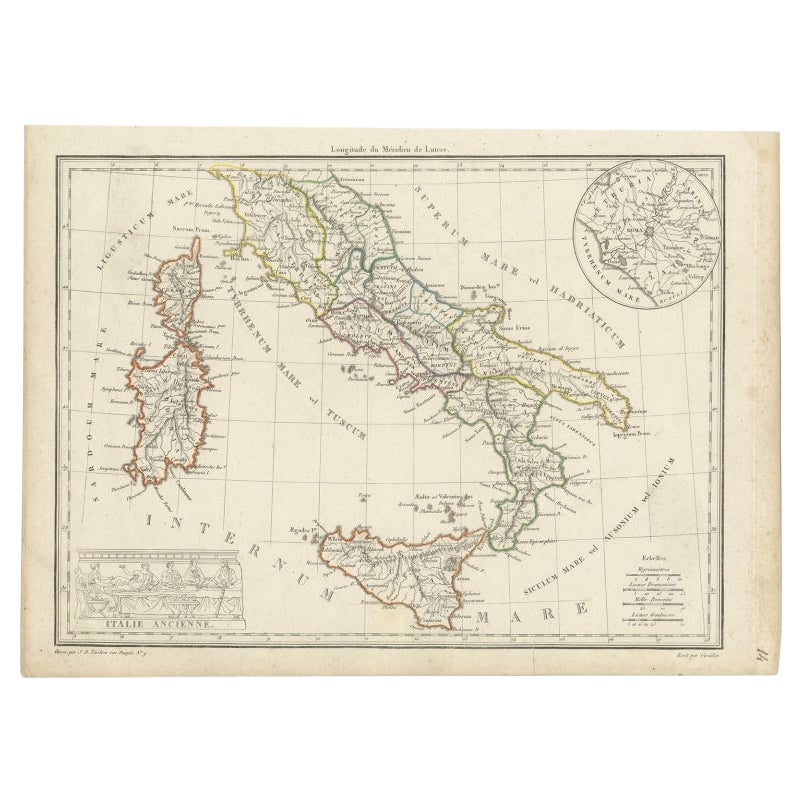
Antique Map of Italy with an Inset of Rome, 1812
Located in Langweer, NL
Antique map titled 'Italie Ancienne'.
Old map of ancient Italy, with an inset map of the region of Rome. This map originates from 'Atlas Supplementaire du Precis de la Geographie...
Category
Antique 19th Century Maps
Materials
Paper
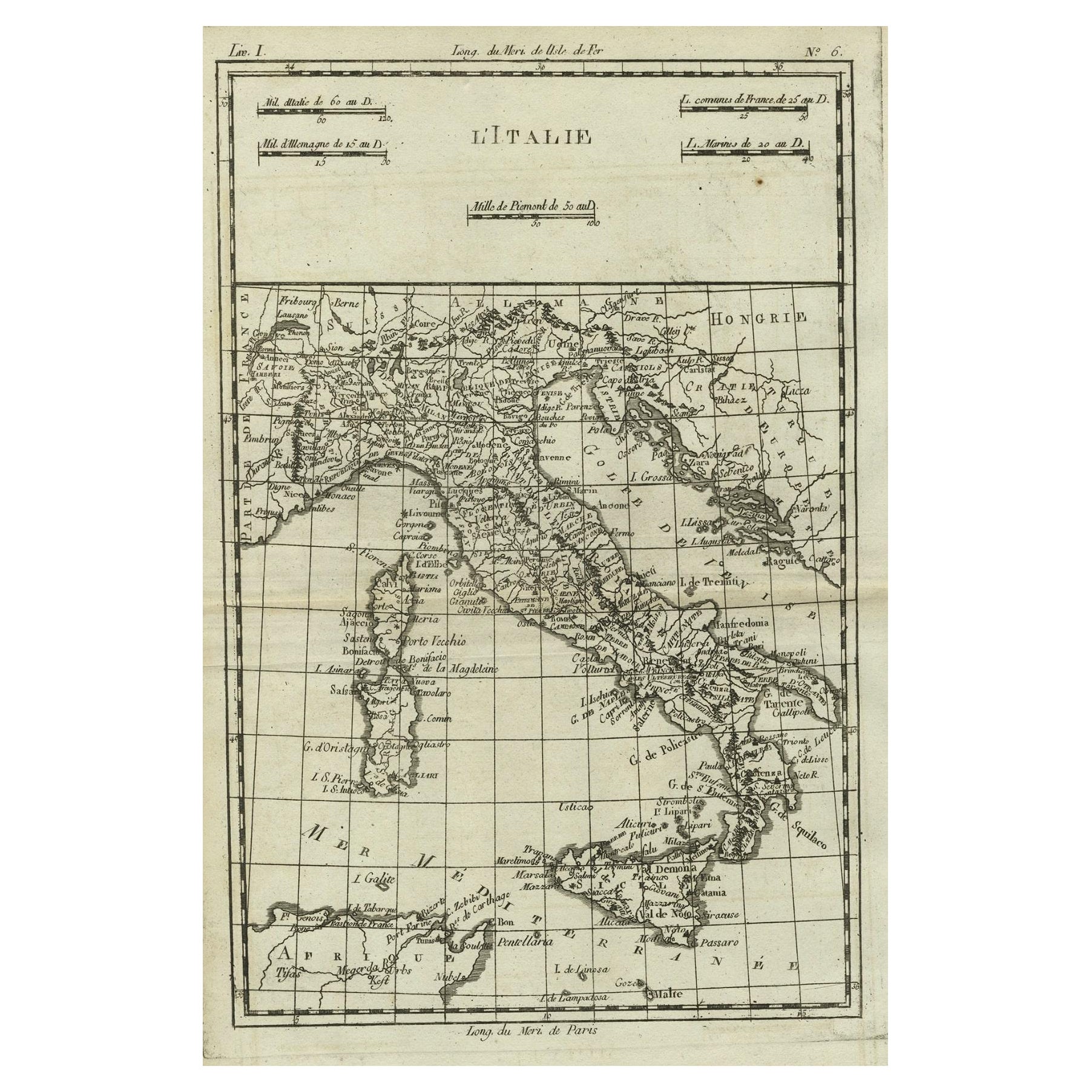
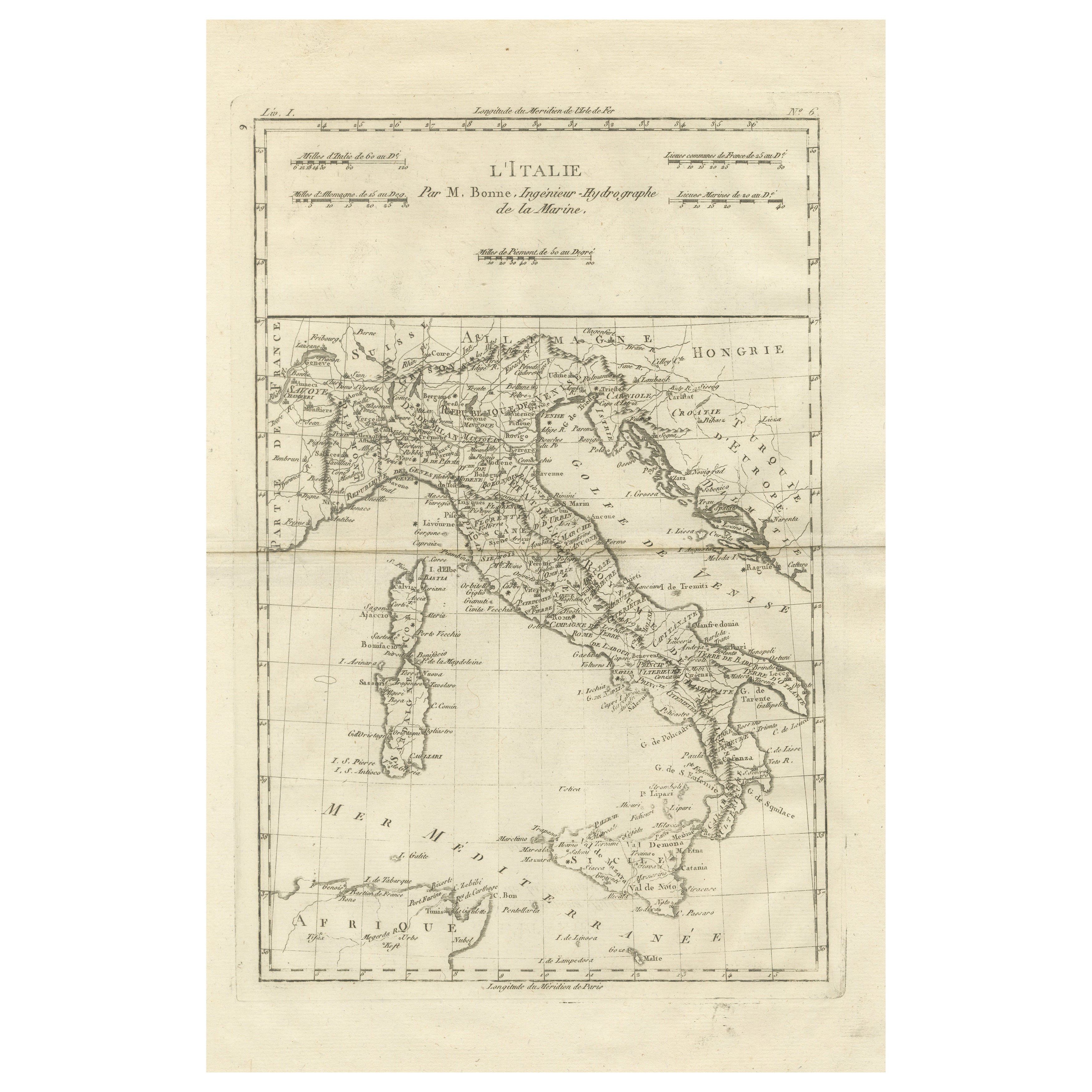
Antique Map of Italy, Corsica, Sardinia and Sicily, ca.1780
Located in Langweer, NL
Description: Antique map titled 'L'Italie.'
Map of Italy, Corsica, Sardinia and Sicily. Highly detailed, showing towns, rivers, some topographical features and political boundaries...
Category
Antique 1780s French Maps
Materials
Paper

$228 Sale Price
40% Off
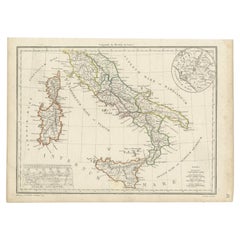
Italy in the Age of Antiquity – Rigobert Bonne French Map c.1780
Located in Langweer, NL
Italy Map by Rigobert Bonne – Classical Peninsula c.1780
DESCRIPTION
This engraved map focuses on the Italian peninsula before national unification. Compiled by Rigobert Bonne, it s...
Category
Antique Late 18th Century French Maps
Materials
Paper
You May Also Like
Map of Italy - Etching by Pierre François Tardieu - 1837
Located in Roma, IT
Map of Italy is an Etching realized in 1837.
Good conditions.
The artwork is realized in a well-balanced composition. the artwork and belongs to the suite suite "AtlasBatt" realize...
Category
1830s Modern Figurative Prints
Materials
Lithograph
Large Original Antique Map of Italy. John Dower, 1861
Located in St Annes, Lancashire
Great map of Italy
Lithograph engraving by John Dower
Original colour
Published, 1861
Unframed
Good condition / repair to top right corner seen in last image
Category
Antique 1860s English Victorian Maps
Materials
Paper

Italy, Central and Southern Part. Century Atlas antique map
Located in Melbourne, Victoria
'The Century Atlas. Italy, Central and Southern Part.'
Original antique map, 1903.
Inset maps of Sicily and Naples.
Central fold as issued. Map name an...
Category
Early 20th Century Victorian More Prints
Materials
Lithograph

17th Century Dutch Map of Italy, Sicily, Sardinia, Corsica and Dalmatian Coast
By Theodorus Danckerts
Located in Alamo, CA
This hand colored 17th century Dutch map entitled "Novissima et Accuratissima totius Italiae Corsicae et Sardiniae Descriptio" by Theodore Danckerts depicts the Italian Peninsula in ...
Category
1690s Prints and Multiples
Materials
Engraving
Antique Map of Italy Drawn
Engraved by R. Scott for Thomsons, Edinburgh 1814
Located in London, GB
This is a magnificent museum quality antique hand-coloured map of Italy, dating from 1814.
This historic and very rare antique map was drawn and engraved by R. Scott for Thomsons, New General Atlas, Edinburgh.
The map is very detailed and the various colours - yellow, grey and green - beautifully highlight the different natural and political divisions of Italy as it was before the Italian Unification...
Category
Antique 1810s Scottish Prints
Materials
Other

Naples and S. Italy: A Large 17th C. Hand-colored Map by Sanson and Jaillot
By Nicholas Sanson d
Abbeville
Located in Alamo, CA
This large hand-colored map entitled "Le Royaume de Naples Divisé en Douze Provinces. sur les Memoires les plus Nouveaux. Par le Sr. Sanson Presenté" was originally created by Nicholas Sanson d'Abbeville and published by Hubert Jaillot in "Atlas Nouveau" in Paris in 1692. It depicts central and southern Italy, as well as Corfu, Albania, Mediterranean Sea and the Adriatic Sea. Naples, Sorrento, the Isle of Capri, Rome in the upper left corner of the map, as well as many other landmarks.
This striking original hand-colored map of Italy is printed on antique hand-made laid, chain-linked paper with wide margins. The sheet measures 20" high and 24.88" wide. There is one spot on the left, it is otherwise in very good to excellent condition.
Nicholas Sanson d'Abbeville (1600-1667) was one of the greatest French cartographather of French cartography. Sanson opened his first printing business in Paris in 1638. The king recognized his skill and knowledge and made him the official geographer to the court. He eventually served two kings in this capacity. Sanson was succeeded by his sons and son...
Category
1690s Landscape Prints
Materials
Engraving
More Ways To Browse
Antique Victorian Dining Tables
Italian Plastic Chairs
Black Crystal Glasses
French Mid Century Modern Rug
China Silk Rug
Chrome Glass Coffee Tables
Antique Italian Chairs
Antique Walnut Bar
Beni Ourain Rugs
French Iron And Glass Table
Glass Top Wood Base Coffee Tables
T Chair
Antique Silver Basket
Antique Walkers
Ebony Wood Furniture
Opalescent Glass
Pair Of Danish Chairs
Veneer Dining Tables