Items Similar to Map of the Kingdom of Sardinia and Part of the Kingdom of Genoa, Rome

Want more images or videos?
Request additional images or videos from the seller
1 of 8
Map of the Kingdom of Sardinia and Part of the Kingdom of Genoa, Rome
$795
$1,25036% Off
£605.38
£951.8536% Off
€697.07
€1,096.0336% Off
CA$1,126.58
CA$1,771.3636% Off
A$1,211.80
A$1,905.3536% Off
CHF 647.62
CHF 1,018.2736% Off
MX$14,283.71
MX$22,458.6636% Off
NOK 8,165.01
NOK 12,838.0636% Off
SEK 7,464.37
SEK 11,736.4236% Off
DKK 5,208.32
DKK 8,189.1836% Off
About the Item
18th century map by Italian engraver Giovanni Maria Cassini (Italy 1745-1824). Map of Part of the Kingdom of Sardinia and Part of the Kingdom of Genoa: Rome. This is a hand colored and copper engraved print done in the year 1791. The third in a series of four maps of "Upper Lombardy". Mounted on board.
Title: "Alta Lombardia terzo folgio che comprende Parte Degli Stati Del Re Di Sardegna e Parte Della Repubblica di Genova. Roma, Presso la Caleograsia Camerale, 1791".
Map size: 19.5" x 14.5"
Mat size: 25.25" x 20.75".
- Creator:Giovanni Maria Cassini (Maker)
- Dimensions:Height: 20.75 in (52.71 cm)Width: 25.25 in (64.14 cm)Depth: 0.1 in (2.54 mm)
- Materials and Techniques:
- Place of Origin:
- Period:
- Date of Manufacture:1791
- Condition:Wear consistent with age and use. Selling with the matting but should be re-matted as it has some wear.
- Seller Location:Hamilton, CA
- Reference Number:1stDibs: LU1355214145771
About the Seller
5.0
Platinum Seller
Premium sellers with a 4.7+ rating and 24-hour response times
Established in 2010
1stDibs seller since 2015
1,367 sales on 1stDibs
Typical response time: 5 hours
- ShippingRetrieving quote...Shipping from: Hamilton, Canada
- Return Policy
More From This Seller
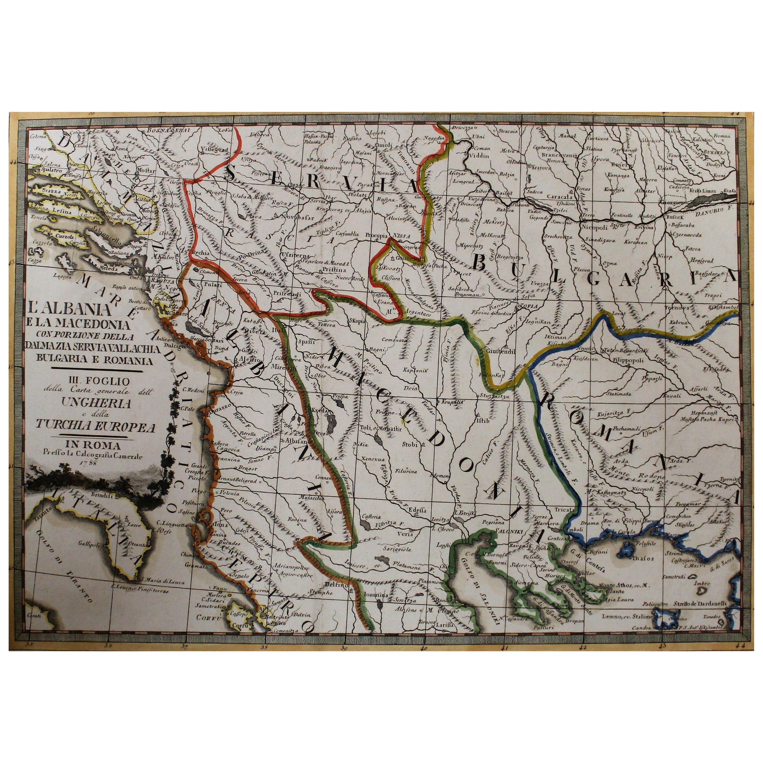
View All18th Century Map of the Southern Balkans by Giovanni Maria Cassini
By Giovanni Maria Cassini
Located in Hamilton, Ontario
18th century map by Italian engraver Giovanni Maria Cassini (Italy 1745-1824).
Map of the Southern Balkans: Rome. Hand colored and copper engraved print done in the year 1788. It in...
Category
Antique 18th Century Italian Maps
Materials
Paper

$795 Sale Price
36% Off
17th Century Nicolas Visscher Map of Southeastern Europe
Located in Hamilton, Ontario
A beautiful, highly detailed map of southeastern Europe by Nicolas Visscher. Includes regions of Northern Italy (showing the cities Bologna, Padua, and Venice), Bohemia, Austria (sho...
Category
Antique 17th Century Dutch Maps
Materials
Paper

$1,350 Sale Price
38% Off
Early 19th Century Hand Colored Map of the United States and Caribbean Islands
Located in Hamilton, Ontario
Hand coloured early 19th century map by Giraldon of France titled "Etats Unis et Grandes Antilles" (United States and Greater Antilles).
Category
Antique Early 19th Century French Maps
Materials
Paper

$595 Sale Price
40% Off
Early 19th Century Hand Coloured Map of North America by Aaron Arrowsmith
By Aaron Arrowsmith
Located in Hamilton, Ontario
Hand coloured map in French by English cartographer Aaron Arrowsmith (1750–1823) titled "Amerique Septentionale" (North America).
Map size: 9.5" x 8"
Mat size: 20.5" x 14.25".
Category
Antique Early 19th Century English Maps
Materials
Paper

$795 Sale Price
36% Off
Antique 1798 James Colnett A Voyage to the South Atlantic
Round Cape Hope Book
Located in Hamilton, Ontario
This antique book titled "A Voyage to the South Atlantic and Round Cape Horn into the Pacific Ocean", and authored by W. Bennett, on the work of James Colnet...
Category
Antique Late 18th Century English Georgian Books
Materials
Leather, Paper
Antique 1719 English "The Compleat Herbal" Volume 1 First Edition Book
By Joseph Pitton de Tournefort
Located in Hamilton, Ontario
This antique first edition book titled "The Compleat Herbal" or 'The botanical institutions of Mr. Tournefort' was published in 1719 in England on paper and bound in leather in the period George 1...
Category
Antique Early 18th Century English George I Books
Materials
Leather, Paper
You May Also Like
Antique Map of Italy, Showing Corsica, Sardinia, Croatia, Malta and More, C.1740
Located in Langweer, NL
Antique map titled 'Nieuwe Kaart van Italie na de Nieuwste waarnemingen van de l'Isle en andere.'
Attractive detailed map showing Italy as well as Corsica, Sardinia, Minorca, Croat...
Category
Antique 18th Century Maps
Materials
Paper

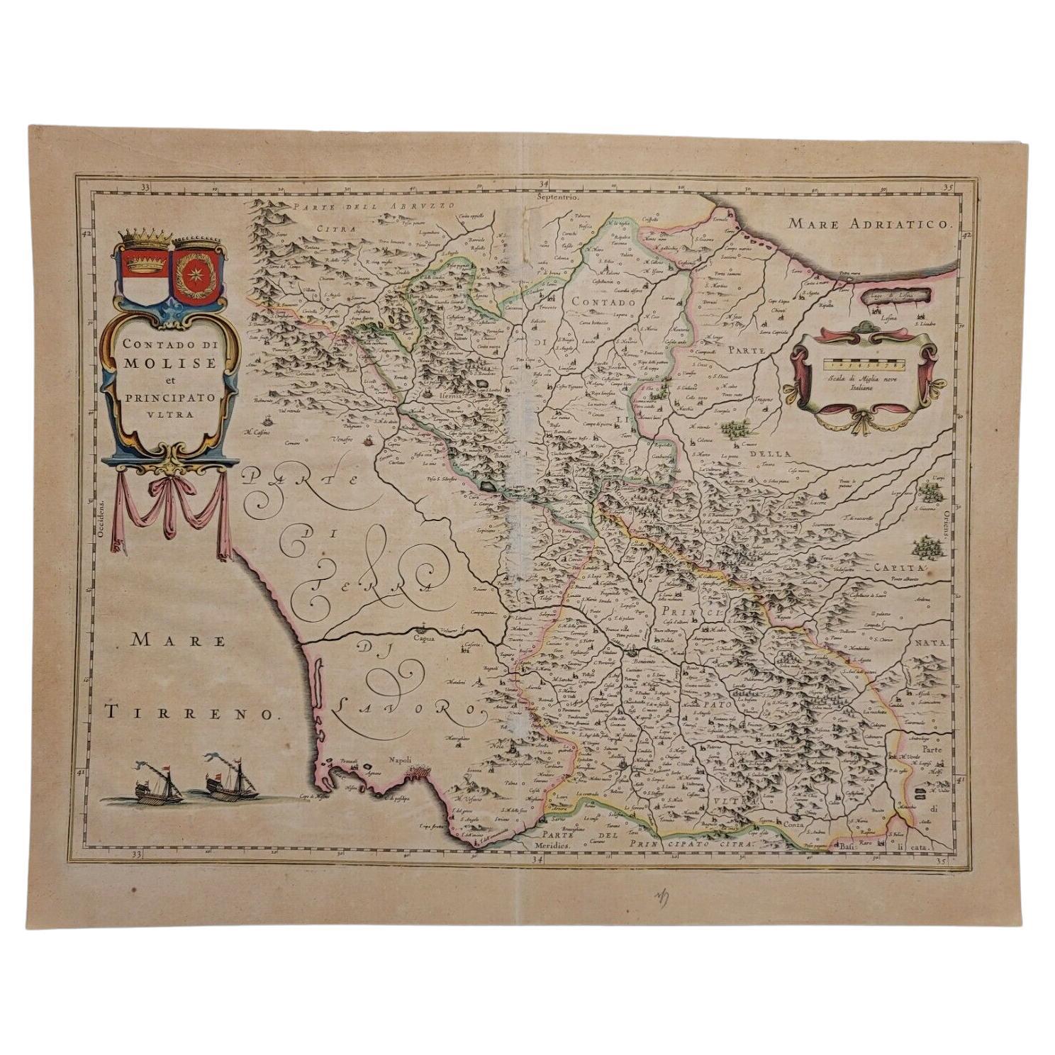
1640 Willem Blaeu Map Entitled "Contado di molise et principato vltra, " Ric.a003
By Willem Blaeu
Located in Norton, MA
1640 Willem Blaeu map entitled
"Contado di molise et principato vltra,"
Colored
Ric. a003
Measures: 38 x 49.6 cm and wide margins
DBLAEU.
Cou...
Category
Antique 17th Century Dutch Maps
Materials
Paper

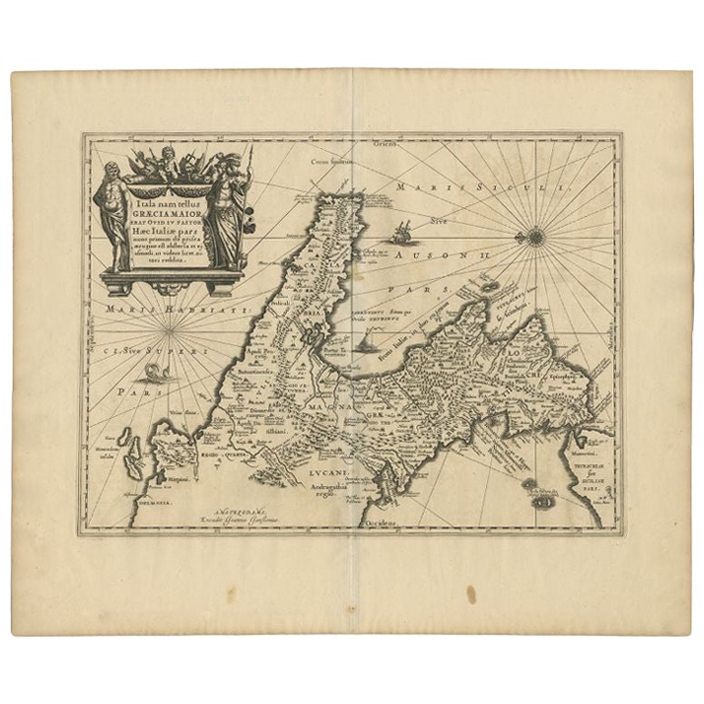
Antique Map of Southern Italy by Janssonius, C.1650
Located in Langweer, NL
"Antique map titled 'Itala nam tellus Graecia Maior erat Ovid. IV. Fastor. Haec Italiae pars nunc primum de prica aerugine est abstersa (..)'. Beautiful map of Southern Italy...
Category
Antique 17th Century Maps
Materials
Paper

$702 Sale Price
20% Off
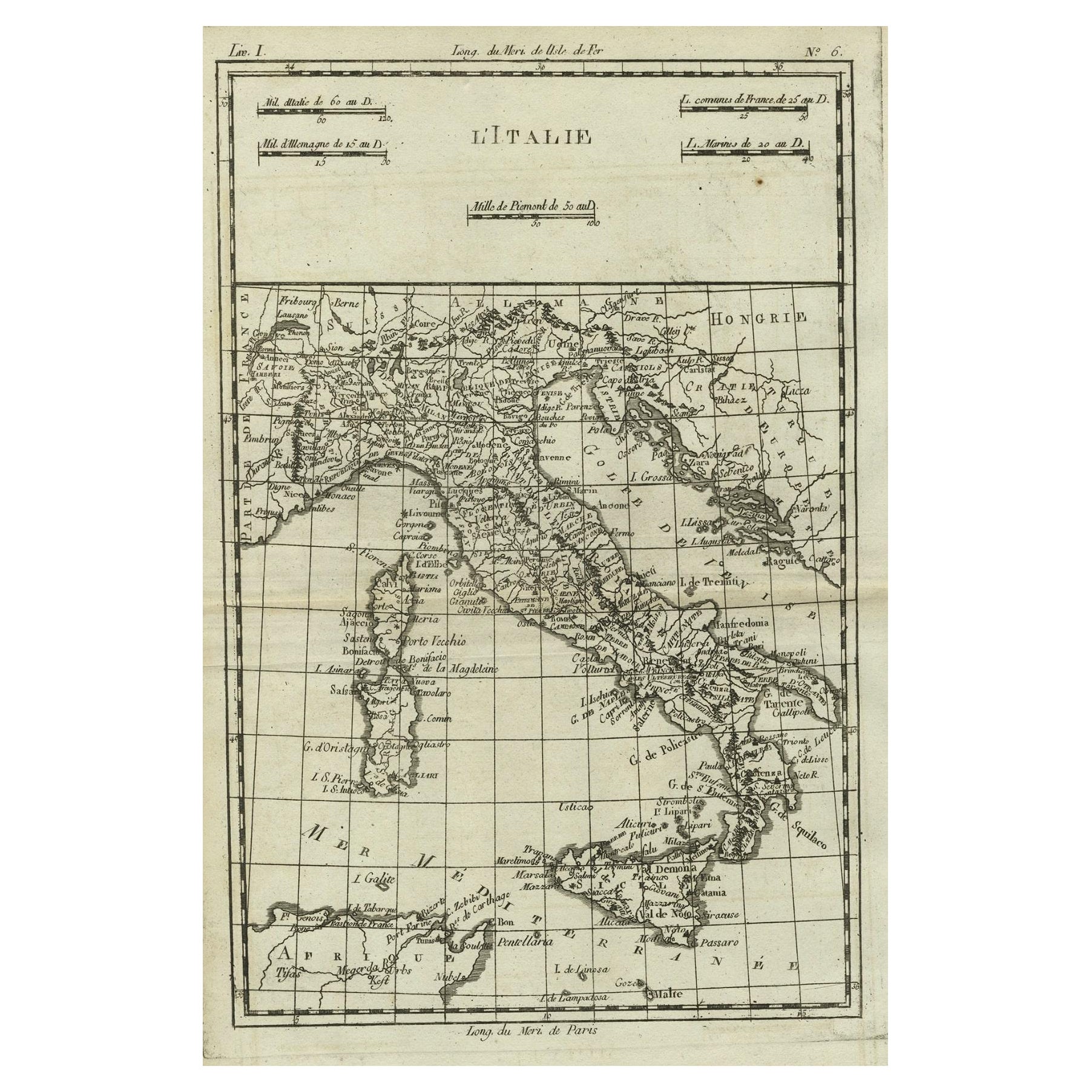
Antique Map of Italy, Corsica, Sardinia and Sicily, ca.1780
Located in Langweer, NL
Description: Antique map titled 'L'Italie.'
Map of Italy, Corsica, Sardinia and Sicily. Highly detailed, showing towns, rivers, some topographical features and political boundaries...
Category
Antique 1780s French Maps
Materials
Paper

$227 Sale Price
40% Off
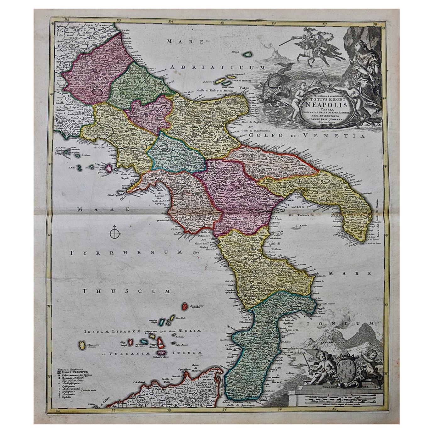
The Kingdom of Naples and Southern Italy: A Hand-Colored 18th Century Homann Map
By Johann Baptist Homann
Located in Alamo, CA
"Novissima & exactissimus Totius Regni Neapolis Tabula Presentis Belli Satui Accommo Data" is a hand colored map of southern Italy and the ancient Kingdom of Naples created by Johann...
Category
Antique Early 18th Century German Maps
Materials
Paper

Antique Map of the Northern Coast of Africa and Southern Europe, circa 1745
By Covens
Mortier
Located in Langweer, NL
Antique map titled 'In Notitiam Ecclesiasticam Africae Tabula Geographica'. Very decorative hand-colored map of the northern coast of Africa, Spain, Italy and the Mediterranean with the islands of Sardinia, Corsica, Majorca, Minorca etc. Sicily features a smoking Mount Aetna. Embellished with three architectural cartouches...
Category
Antique Mid-18th Century Maps
Materials
Paper

$310 Sale Price
67% Off
More Ways To Browse
Antique Maps Of Italy
Sardinia Map
Antique English Maps
Indonesia Map
Ancient Maps
Antique Mining
Antique Atlas Furniture
Antique Maps Indonesia
Map Of India
China Map
Victorian Furniture 1920
Antique Maps Amsterdam
Antique Maps Of Russia
19th Century Map Of Africa
Map Of Britain
Antique Oregon
Bali Wood
Railroad Furniture