Items Similar to Map of Loiret France with Orléans and Loire River by Vuillemin, 19th c


Want more images or videos?
Request additional images or videos from the seller
1 of 10
Map of Loiret France with Orléans and Loire River by Vuillemin, 19th c
$263.13
£195.39
€220
CA$361.51
A$393.03
CHF 208.38
MX$4,711.43
NOK 2,648.46
SEK 2,426.35
DKK 1,677.11
About the Item
Map of Loiret France with Orléans and Loire River by Vuillemin, 19th c
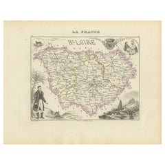
This antique hand-colored map of the Loiret department, engraved by Alexandre Vuillemin and published by Migeon in the mid-19th century, is part of the renowned Nouvel Atlas Illustré des Départements et des Colonies. Both a geographic document and a decorative piece, this map showcases the region’s detailed topography, cultural history, and political divisions during the 1800s.
At the heart of the map is the city of Orléans, the prefecture of Loiret and one of France’s most historically significant cities, located on the banks of the Loire River. The map depicts the river's meandering course and highlights the surrounding communes, roads, rail lines, and departmental borders, delicately outlined in green. Several rivers, including the Loiret, Loing, and Essonne, are also marked, as are forests and agricultural zones.
The upper right vignette offers a finely rendered panoramic view of Orléans, complete with the towers of Orléans Cathedral and the city’s famous bridge crossing the Loire. In the upper left is a portrait of the painter Girodet de Roucy-Trioson, a native of Montargis, whose work bridges the neoclassical and romantic movements. The lower right contains the departmental coat of arms, framed with botanical ornamentation.
Loiret is part of the Loire Valley, a UNESCO-listed region celebrated for its châteaux and wine production. While better known for white wines to the west, Loiret itself produces several regional wines including Orléans AOC and Orléans-Cléry AOC, with reds based on Pinot Meunier and Cabernet Franc. Vineyards around Meung-sur-Loire, Mareau-aux-Prés, and Cléry-Saint-André remain active, continuing a tradition that stretches back to medieval times.
Alexandre Vuillemin (1812–1880) was a respected cartographer whose maps are prized for their fine engraving, clarity, and the integration of historical and artistic detail. His maps for Migeon’s atlas series combine cartographic accuracy with visual storytelling, making them both educational tools and decorative objects.
Condition summary:
Very good antique condition with light toning at the edges and faint foxing in the margins. Plate imprint strong, original color fresh and intact.
Framing tips:
Frame in a traditional gold or black wood frame. Use a light beige or soft grey mat to enhance the engraving and green border tones. UV-protective glass is recommended for preserving the color and fine linework.
Key Locations Featured on the Map of Loiret:
1. Orléans – Capital of Loiret, cultural and historic hub
2. Montargis – Subprefecture and canal town
3. Pithiviers – Subprefecture in the north
4. Châteauneuf-sur-Loire – Along the Loire
5. Beaugency – Historic riverside town
6. Meung-sur-Loire – Literary and wine-producing town
7. Briare – Known for its canal and aqueduct
8. Gien – Town with a faience factory and castle
9. Sully-sur-Loire – Château and gateway to the Sologne
10. Artenay – Northern railway hub
11. Jargeau – Medieval town on the Loire
12. Saint-Jean-de-Braye – Suburban to Orléans
13. Saint-Jean-le-Blanc – On the Loire’s left bank
14. Olivet – Loiret River runs through this commune
15. La Chapelle-Saint-Mesmin – West of Orléans
16. Ingré – Growing suburb west of Orléans
17. Saran – Industrial suburb north of Orléans
18. Chécy – Loire canal town
19. Châteaurenard – On the Yonne border
20. Ferrières-en-Gâtinais – Medieval abbey town
21. Lorris – Historic market town in the Forêt d’Orléans
22. Ouzouer-sur-Loire – Eastern edge, near forests
23. Neuville-aux-Bois – Rural commune
24. Courtenay – Near the northern boundary
25. Bellegarde – Town with Renaissance architecture
26. Chilleurs-aux-Bois – In the Beauce plain
27. Sermaises – Market village
28. Fay-aux-Loges – Canal town
29. Dampierre-en-Burly – Southeast, forested region
30. Ouzouer-le-Marché – Northeastern Loiret
31. Patay – Battlefield of Joan of Arc’s campaign
32. Malesherbes – Northern limits of Loiret
33. Saint-Denis-en-Val – East of Orléans
34. Saint-Jean-de-la-Ruelle – West Orléans suburb
35. Cléry-Saint-André – Pilgrimage site and wine village
36. Marigny-les-Usages – North of Orléans
37. Traînou – Forested commune
38. Sandillon – Southeast of Orléans
39. Tigy – Village near Sologne
40. Vienne-en-Val – Agricultural area
41. Ouvrouer-les-Champs – East of Orléans
42. Saint-Père-sur-Loire – Opposite Sully
43. Châtillon-sur-Loire – Overlooking the Loire and canal
44. Ligny-le-Ribault – Forest and game lands
45. Saint-Loup-des-Vignes – Rural commune
46. Rebréchien – North of Orléans
47. Boulay-les-Barres – Between Orléans and Artenay
48. Bouzy-la-Forêt – On the edge of the Forêt d’Orléans
49. Boiscommun – Near Lorris
50. Courcelles – Southeast of Montargis
- Dimensions:Height: 10.28 in (26.1 cm)Width: 12.8 in (32.5 cm)Depth: 0.01 in (0.2 mm)
- Materials and Techniques:Paper,Engraved
- Place of Origin:
- Period:
- Date of Manufacture:circa 1850
- Condition:Very good antique condition with light toning at the edges and faint foxing in the margins. Plate imprint strong, original color fresh and intact.
- Seller Location:Langweer, NL
- Reference Number:Seller: BG-13331-441stDibs: LU3054347401192
About the Seller
5.0
Recognized Seller
These prestigious sellers are industry leaders and represent the highest echelon for item quality and design.
Platinum Seller
Premium sellers with a 4.7+ rating and 24-hour response times
Established in 2009
1stDibs seller since 2017
2,823 sales on 1stDibs
Typical response time: 1 hour
- ShippingRetrieving quote...Shipping from: Langweer, Netherlands
- Return Policy
More From This Seller
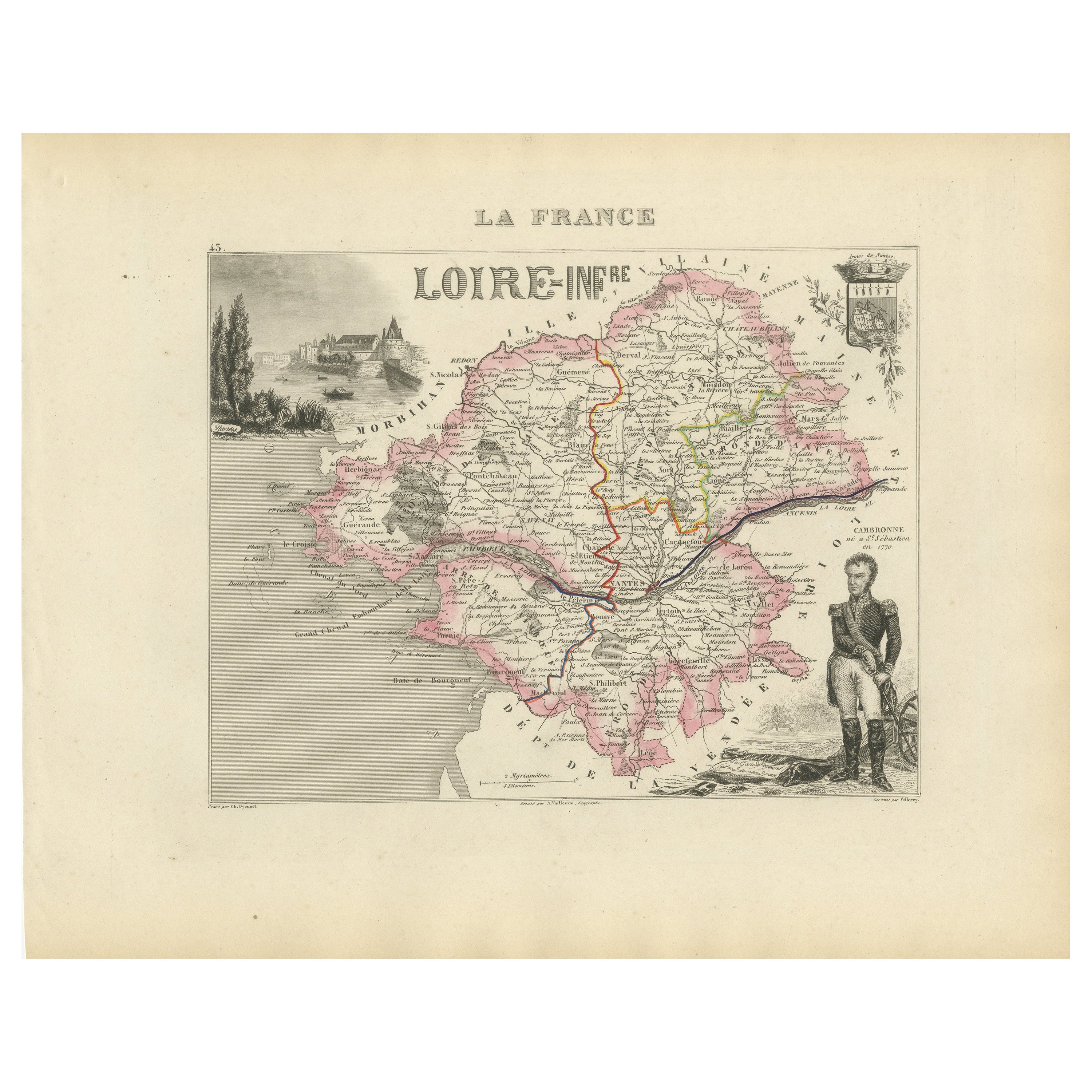
View AllMap of Loire-Inférieure France with Nantes and Estuary by Vuillemin, 19th c
Located in Langweer, NL
Map of Loire-Inférieure France with Nantes and Estuary by Vuillemin, 19th c
This finely engraved and hand-colored map of Loire-Inférieure (modern-day Loire-Atlantique) was created b...
Category
Antique Mid-19th Century French Maps
Materials
Paper
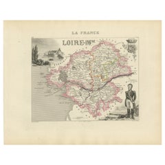
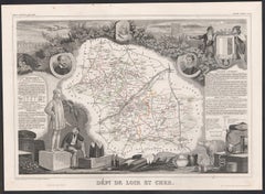
Map of Loire France with Saint-Étienne and Montbrison by Vuillemin, 19th c
Located in Langweer, NL
Map of Loire France with Saint-Étienne and Montbrison by Vuillemin, 19th c
This beautifully engraved and hand-colored map of the department of Loire in east-central France is from t...
Category
Antique Mid-19th Century French Maps
Materials
Paper

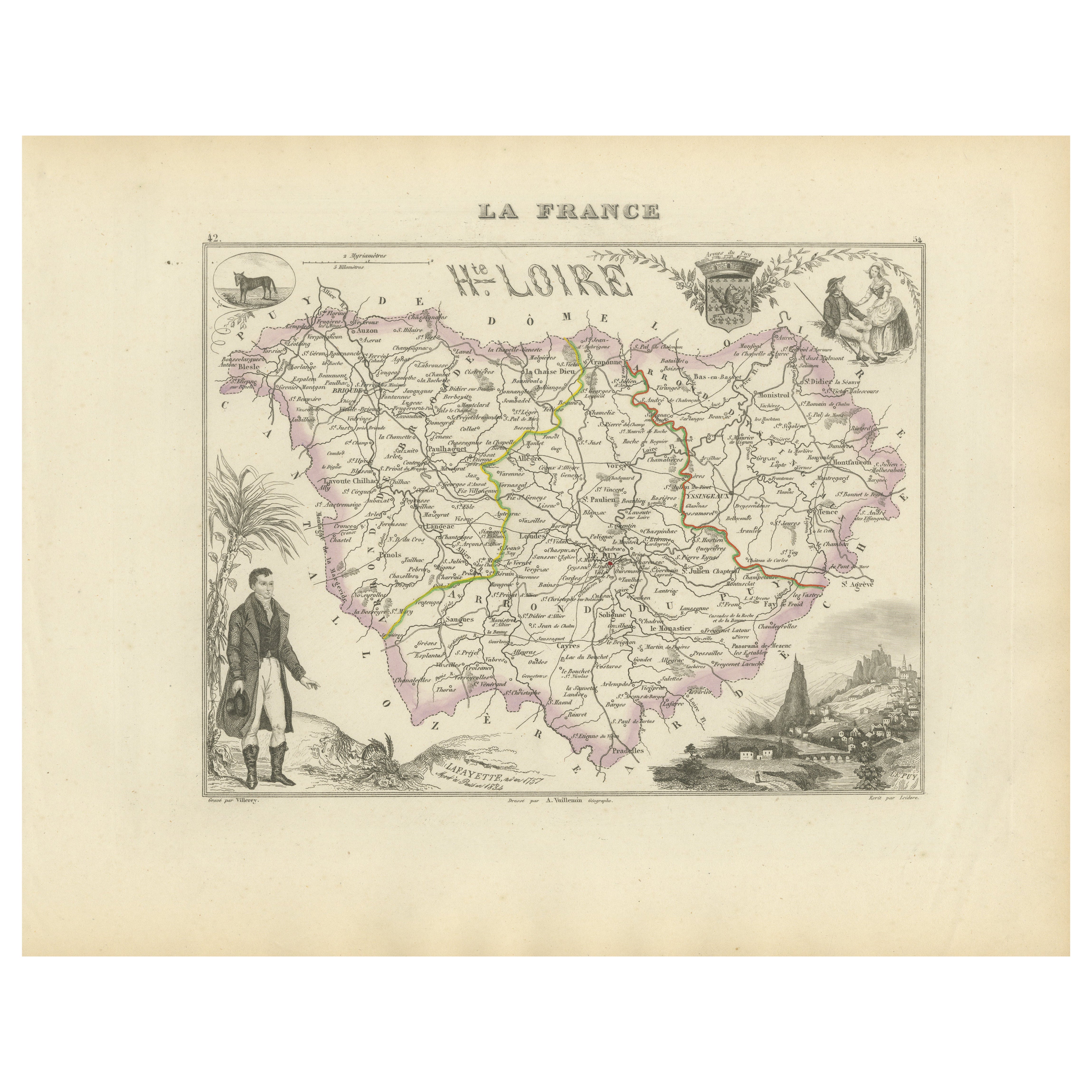
Map of Haute-Loire France with Le Puy-en-Velay by Vuillemin, 19th c
Located in Langweer, NL
Map of Haute-Loire France with Le Puy-en-Velay by Vuillemin, 19th c
This 19th-century hand-colored map of the Haute-Loire department in south-central France is from Alexandre Vuille...
Category
Antique Mid-19th Century French Maps
Materials
Paper
Map of Allier France with Saint-Pourçain Wine Region by Vuillemin, 19th c
Located in Langweer, NL
Map of Allier France with Saint-Pourçain Wine Region by Vuillemin, 19th c
This decorative 19th-century map of Allier, a central department of France, comes from the celebrated Nouve...
Category
Antique Mid-19th Century French Maps
Materials
Paper

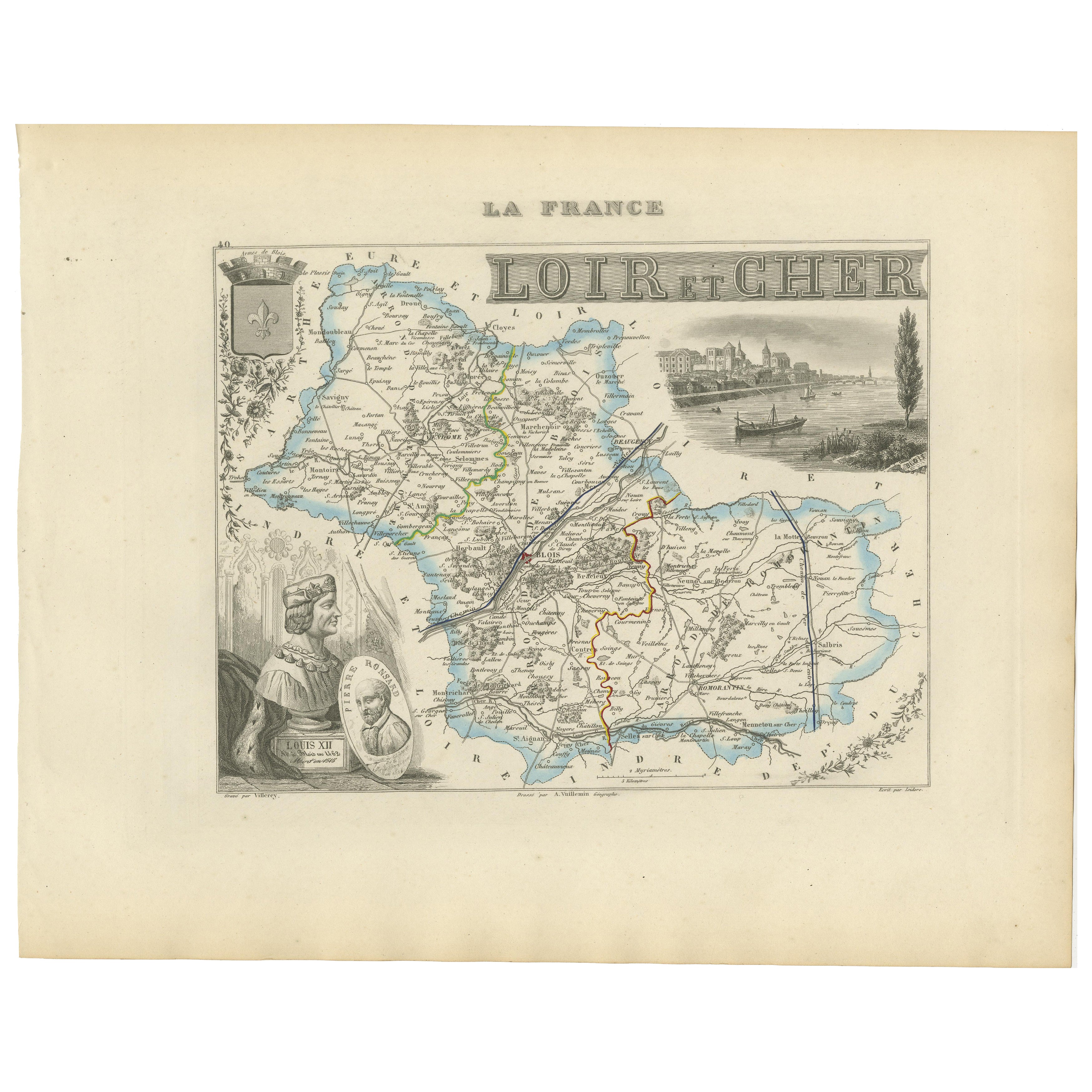
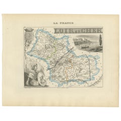
19th Century Map of Loir-et-Cher, France – Blois, Vendôme, Loire Valley Castles
Located in Langweer, NL
Antique Map of Loir-et-Cher, France by Vuillemin, 19th Century
A beautifully engraved 19th-century map of the département of Loir-et-Cher, drawn and engraved by Alexandre Vuillemin....
Category
Antique Mid-19th Century French Maps
Materials
Paper
Map of Côtes-du-Nord France with Saint-Brieuc and Brittany Coastline, c.1850
Located in Langweer, NL
Map of Côtes-du-Nord France with Saint-Brieuc and Brittany Coastline, 19th c
Description:
This elegant 19th-century map of Côtes-du-Nord, the historic name for what is now known as ...
Category
Antique Mid-19th Century French Maps
Materials
Paper

You May Also Like
Saone and Loire, France. Antique map of a French department, 1856
By Victor Levasseur
Located in Melbourne, Victoria
'Dept. de Saone et Loire', steel engraving with original outline hand-colouring., 1856, from Levasseur's Atlas National Illustre.
The French department of Saone et Loire is at the ...
Category
19th Century Naturalistic Landscape Prints
Materials
Engraving

Indre and Loire, France. Antique map of a French department, 1856
By Victor Levasseur
Located in Melbourne, Victoria
'Dept. d'Indre et Loire', steel engraving with original outline hand-colouring., 1856, from Levasseur's 'Atlas National Illustre'.
This area is known for its production of Chenin b...
Category
19th Century Naturalistic Landscape Prints
Materials
Engraving

Aube, France. Antique map of a French department, 1856
By Victor Levasseur
Located in Melbourne, Victoria
'Dept. de L'Aube', steel engraving with original outline hand-colouring., 1856, from Levasseur's 'Atlas National Illustre'.
This area of France is known for its production of Chaou...
Category
19th Century Naturalistic Landscape Prints
Materials
Engraving

L
Isere, France. Antique map of French department, 1856
By Victor Levasseur
Located in Melbourne, Victoria
'Dept. de L'Isere', Steel engraving with original outline hand-colouring., 1856, from Levasseur's 'Atlas National Illustre'.
This area is known for its production of Bleu du Vercor...
Category
19th Century Naturalistic Landscape Prints
Materials
Engraving

Loir and Cher, France. Antique map of a French department, 1856
By Victor Levasseur
Located in Melbourne, Victoria
'Dept. de Loir and Cher', steel engraving with original outline hand-colouring., 1856, from Levasseur's Atlas National Illustre.
This area is mainly known for its production of Sel...
Category
19th Century Naturalistic Landscape Prints
Materials
Engraving
Large 19th Century Map of France
Located in Pease pottage, West Sussex
Large 19th Century Map of France.
Remarkable condition, with a pleasing age worn patina.
Recently framed.
France Circa 1874.
Category
Antique Late 19th Century French Maps
Materials
Linen, Paper
