Items Similar to Map of the Netherlands with Insets of Amsterdam and Arnhem, Leiden 1876

Want more images or videos?
Request additional images or videos from the seller
1 of 11
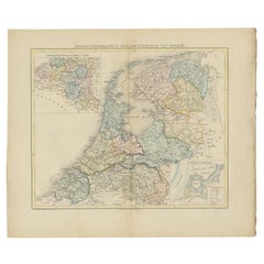
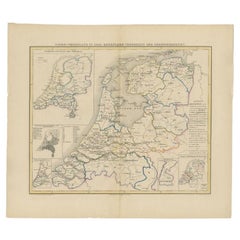
Map of the Netherlands with Insets of Amsterdam and Arnhem, Leiden 1876
$383.31
£286.63
€320
CA$528.10
A$575.97
CHF 305.11
MX$6,905.06
NOK 3,885.74
SEK 3,553.22
DKK 2,438.53
About the Item
Map of the Netherlands with Insets of Amsterdam and Arnhem, Leiden 1876
This detailed 19th-century Dutch map, titled “De Nederlanden,” was published in 1876 in the Nieuwe Hand-Atlas der Aarde in haren Tegenwoordigen Toestand* by M. Frijlink, revised by A. van Otterloo, and printed by D. Noothoven van Goor in Leiden. It presents a finely engraved overview of the Netherlands, capturing the country’s provinces, waterways, and cities in remarkable detail during the late 19th century, shortly after major national infrastructure developments and land reclamations.
The provinces are outlined in distinct hand-colored borders—red, yellow, green, and blue—while rivers, canals, and railways are clearly indicated. Towns, villages, and key geographic features such as the Zuiderzee, the Rhine delta, and the Frisian islands are precisely labeled. Insets enrich the presentation with detailed maps of *Amsterdam en Haarlem*, *’s-Gravenhage (The Hague)*, and *Arnhem en Omstreken*, offering a close look at urban and regional layouts. The typography and layout reflect the elegant and systematic cartographic style typical of Dutch educational atlases of the 19th century.
This map formed part of Frijlink’s *Nieuwe Hand-Atlas*, a standard reference work used in schools and institutions throughout the Netherlands. Its combination of aesthetic clarity and geographic accuracy reflects the high standards of lithographic printing achieved by the Leiden publisher Noothoven van Goor.
Condition report:
Good condition with light even toning and minor foxing around the outer margins. Original center fold as issued. The printed image is crisp, and the coloring remains fresh and even. No tears or repairs.
Framing tips:
A soft ivory or light beige mat with a slim black or dark oak frame complements the detailed engraving and balanced composition. Ideal for display in a home office, library, or hallway, especially when paired with companion maps from the same atlas.
Technique: Lithograph with original hand-coloring
Maker: M. Frijlink
A. van Otterloo, published by D. Noothoven van Goor, Leiden, 1876
- Dimensions:Height: 21.66 in (55 cm)Width: 17.33 in (44 cm)Depth: 0.01 in (0.2 mm)
- Materials and Techniques:
- Place of Origin:
- Period:
- Date of Manufacture:1876
- Condition:Good condition with light even toning and minor foxing around the outer margins. Original center fold as issued. The printed image is crisp, and the coloring remains fresh and even. No tears or repairs.
- Seller Location:Langweer, NL
- Reference Number:Seller: BG-12788-121stDibs: LU3054347454962
About the Seller
5.0
Recognized Seller
These prestigious sellers are industry leaders and represent the highest echelon for item quality and design.
Platinum Seller
Premium sellers with a 4.7+ rating and 24-hour response times
Established in 2009
1stDibs seller since 2017
2,788 sales on 1stDibs
Typical response time: <1 hour
- ShippingRetrieving quote...Shipping from: Langweer, Netherlands
- Return Policy
More From This Seller
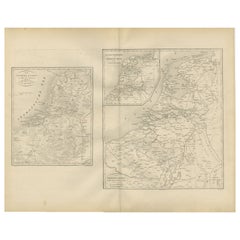
View AllHistorical Map of the Netherlands in the 16th and 17th Centuries, Leiden 1876
Located in Langweer, NL
Historical Map of the Netherlands in the 16th and 17th Centuries, Leiden 1876
This 19th-century Dutch historical map, titled “De Nederlanden in het begin der 16de eeuw en in het beg...
Category
Antique 1870s Dutch Maps
Materials
Paper
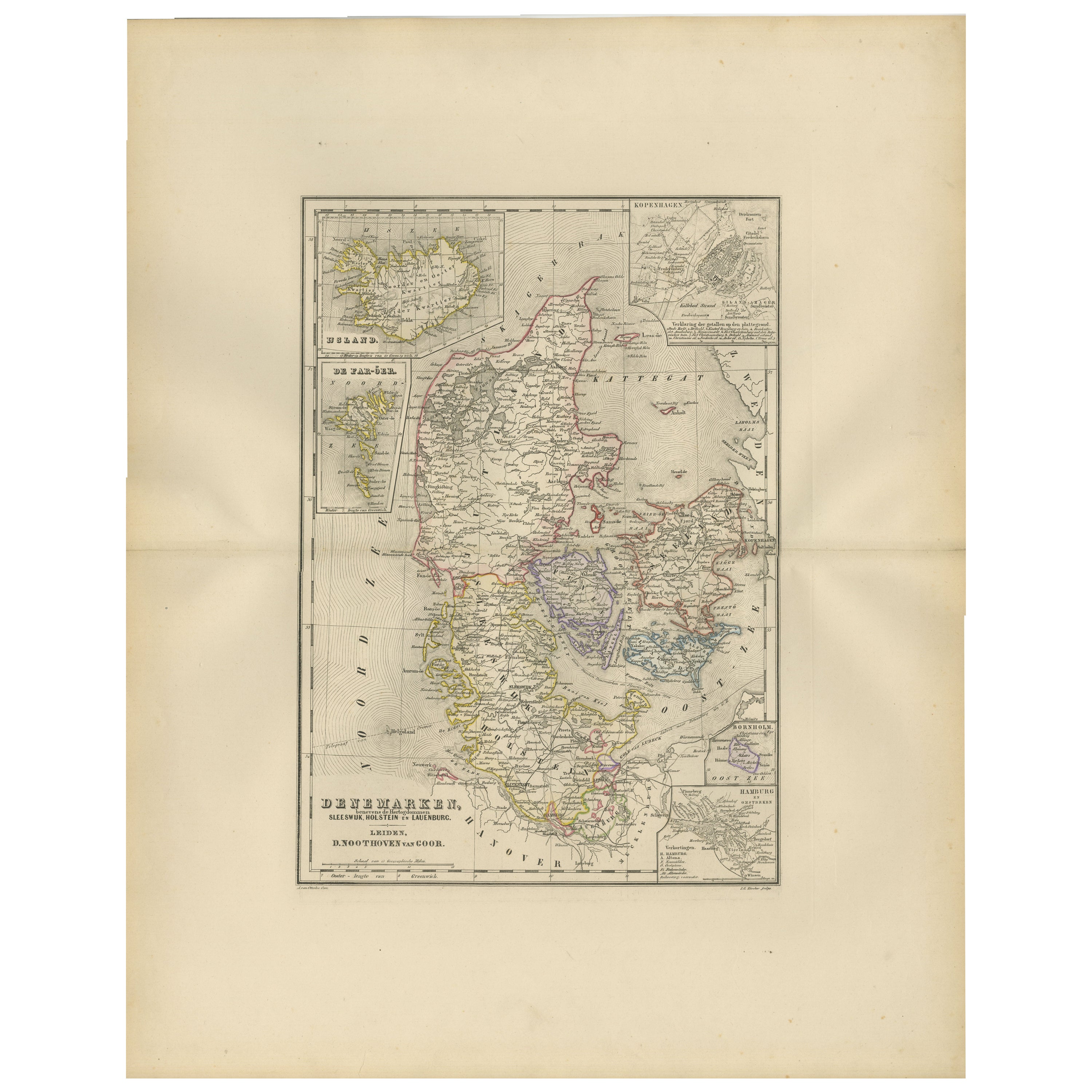
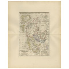
Map of Denmark, Schleswig, Holstein and Lauenburg – Leiden 1876
Located in Langweer, NL
Title: Map of Denmark, Schleswig, Holstein and Lauenburg – Leiden 1876
Description:
This 19th-century Dutch map, titled “Denemarken, Sleeswijk, Holstein en Lauenburg,” was published...
Category
Antique 1870s Dutch Maps
Materials
Paper
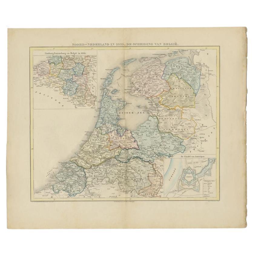
Antique Map of the Netherlands in 1839 by Mees, 1860
Located in Langweer, NL
Antique map titled 'Noord-Nederland in 1839. De scheiding van België'. Map of the Netherlands in 1839. This map originates from 'Historische Atlas van Noord-Nederland'.
Artists a...
Category
Antique 19th Century Maps
Materials
Paper
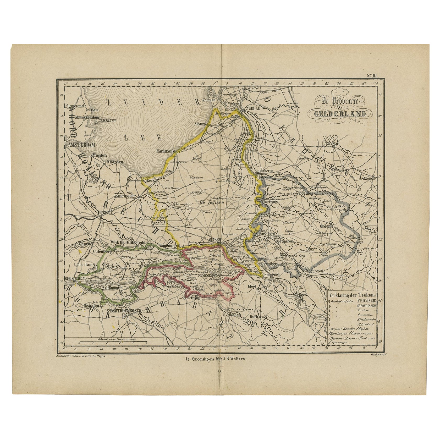
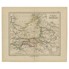
Antique Map of Gelderland with the Veluwe Etc, the Netherlands, 1864
Located in Langweer, NL
Antique map titled 'De Provincie Gelderland'. Map of the province of Gelderland, the Netherlands.
This map originates from 'F. C. Brugsma's Atlas van het Koninkrijk der Nederland...
Category
Antique 19th Century Maps
Materials
Paper
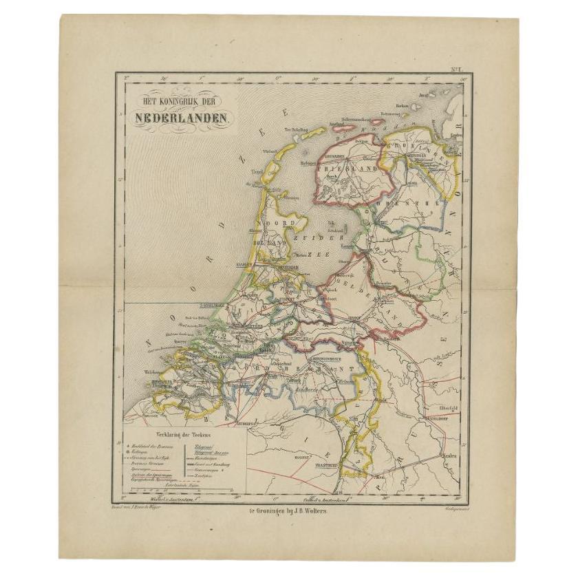
Antique Map of the Netherlands by Brugsma, 1864
Located in Langweer, NL
Antique map titled 'Het Koningrijk der Nederlanden'. Map of the Netherlands. This map originates from 'F. C. Brugsma's Atlas van het Koninkrijk ...
Category
Antique 19th Century Maps
Materials
Paper

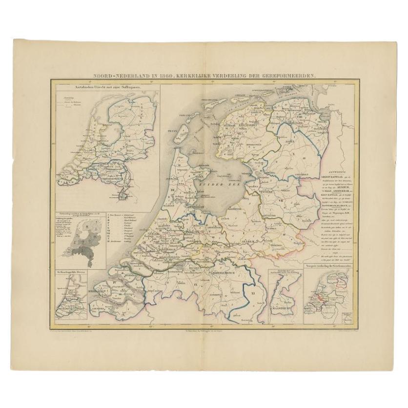
Antique Map of the Netherlands in 1860 by Mees, 1862
Located in Langweer, NL
Antique map titled 'Noord-Nederland in 1860. Kerkelijke verdeeling der Gereformeerden'. Map of the Netherlands in 1860. This map originates from 'Historische Atlas van Noord-Nederlan...
Category
Antique 19th Century Maps
Materials
Paper
You May Also Like
The Netherlands (Holland), Belgium and Luxemburg. Century Atlas antique map
Located in Melbourne, Victoria
'The Century Atlas. The Netherlands (Holland), Belgium and Luxemburg.'
Original antique map, 1903.
Inset maps of 'Amsterdam' and 'Brussels'.
Central fold as issued. Map name and num...
Category
Early 20th Century Victorian More Prints
Materials
Lithograph

1839 Map of Karte Des "Russischen Reiches in Europa Und Asien" Ric.R0013
Located in Norton, MA
1839 map of Karte Des
"Russischen Reiches in Europa and Asien"
Ric.r013
Map of the European and Asian parts of Russian Empire. Karte der Russischen Reiches in Europa und Asien...
Category
Antique 19th Century Unknown Maps
Materials
Paper

1849 Map of "Europaische Russland",
Meyer Map of European Russia
, Ric. R017
Located in Norton, MA
1849 Map of
"Europaische Russland"
( Meyer Map of European Russia)
Ric.r017
A lovely map of European Russia dating to 1849 by Joseph Meyer. It covers the European portions of...
Category
Antique 19th Century Unknown Maps
Materials
Paper

1752 Vaugoundy Map of Flanders : Belgium, France, and the Netherlands, Ric.a002
Located in Norton, MA
Large Vaugoundy Map of Flanders:
Belgium, France, and the Netherlands
Colored -1752
Ric.a002
Description: This is a 1752 Didier Robert de Vaugondy map of Flanders. The map de...
Category
Antique 17th Century Unknown Maps
Materials
Paper

Original Antique English County Map, Nottinghamshire, J
C Walker, 1851
Located in St Annes, Lancashire
Great map of Nottinghamshire
Original colour
By J & C Walker
Published by Longman, Rees, Orme, Brown & Co. 1851
Unframed.
Category
Antique 1850s English Other Maps
Materials
Paper

Original Antique English County Map, Huntingdonshire, J
C Walker, 1851
Located in St Annes, Lancashire
Great map of Huntingdonshire
Original colour
By J & C Walker
Published by Longman, Rees, Orme, Brown & Co. 1851
Unframed.
Category
Antique 1850s English Other Maps
Materials
Paper
