Items Similar to Map of Northwestern Switzerland (Basel and Zurich Region) by Willem
Jan Blaeu


Want more images or videos?
Request additional images or videos from the seller
1 of 8
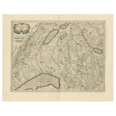
Map of Northwestern Switzerland (Basel and Zurich Region) by Willem
Jan Blaeu
$910.33
$1,317.5930% Off
£680.94
£985.5830% Off
€760
€1,10030% Off
CA$1,254.40
CA$1,815.5730% Off
A$1,378.89
A$1,995.7630% Off
CHF 723.91
CHF 1,047.7630% Off
MX$16,395.95
MX$23,730.9930% Off
NOK 9,296.64
NOK 13,455.6630% Off
SEK 8,468.23
SEK 12,256.6530% Off
DKK 5,791.99
DKK 8,383.1430% Off
About the Item
Map of Northwestern Switzerland by Willem
Jan Blaeu (Circa 1650)
This is a detailed map of Northwestern Switzerland, specifically depicting the region between Basel and Zurich, created by the renowned Dutch cartographers Willem and Jan Blaeu around 1650. It is part of a larger series of regional maps of Switzerland produced by the Blaeu family.
Key Features:
1. Geographical Context:
- The map covers the northern part of Switzerland, showing the area between the cities of Basel and Zurich, including notable towns, rivers, and mountain ranges.
- Areas such as "Zurichgow" (Zurichgau) and the "Basilensis Provincia" (Basel Province) are prominently labeled.
2. Influence and Sources:
- The geography of this map is based on earlier maps produced by the Hondius family, who themselves drew heavily from the works of Gerardus Mercator, one of the most famous and influential cartographers of the time. Blaeu openly acknowledged Mercator’s work as the foundation of his Swiss regional maps.
3. Artistic and Cartographic Details:
- The map is ornately decorated with a cartouche at the top, labeling the Zurichgau and Basel provinces. These cartouches are a hallmark of Blaeu maps, combining functionality with artistic flair.
- The rivers, mountain ranges, and forests are intricately illustrated, with shading and elevation lines providing a sense of topography.
4. Original Hand Coloring:
- This particular map has been colored by hand, a common practice in the 17th century to enhance the visual appeal of maps for wealthy patrons. The use of color delineates political boundaries, regions, and geographical features.
5. Map Size and Condition:
- The map dimensions are 15 x 19 ½ inches (38 x 50 cm). The relatively large size allows for a detailed representation of the region.
- The map is in good condition with wide margins, a feature that would have helped preserve the map over time.
6. Historical Importance:
- As one of a series of Swiss regional maps, it reflects the growing interest in detailed geographical representation during the early modern period. It would have been part of an atlas designed for scholars, nobility, or travelers seeking knowledge of the region.
- The reverse side of the map contains text in Dutch, which was common in Blaeu’s atlases, offering additional descriptions or historical context about the regions depicted.
Artistic and Historical Value:
Willem and Jan Blaeu were part of a prominent family of cartographers during the golden age of Dutch cartography. Their maps are considered masterpieces of both accuracy and artistry. This map of Northwestern Switzerland offers not only a functional geographical reference but also serves as a work of art, with its detailed hand coloring, decorative cartouches, and precise topography. It remains a valuable collectible item, sought after by map enthusiasts and historians.
This map of Northwestern Switzerland by Willem and Jan Blaeu (circa 1650) highlights several important regions, towns, and geographical features. Some key locations and areas of significance include:
### 1. **Basel (Basilea)**
- Located at the northwestern edge of the map, Basel is prominently displayed as a major city and strategic location on the Rhine River. As a historical hub of commerce, culture, and academia, Basel was important for trade and intellectual exchange in Europe.
### 2. **Zurich (Zurichgow or Zurichgau)**
- Located in the eastern part of the map, Zurich is another significant Swiss city, known for its economic influence and status as a major cultural and political center in Switzerland. Zurichgau refers to the surrounding region governed from Zurich.
### 3. **Aargau (Argow)**
- This region lies in the central part of the map and is marked as “Argow.” Aargau is historically important due to its strategic location along the Aare River and its proximity to both Zurich and Basel. It was a key area for agriculture and trade.
### 4. **Rheinfelden (Rhenfelden)**
- Positioned along the Rhine River, Rheinfelden was a strategically important town near Basel. Its location on the river made it vital for controlling regional trade routes.
### 5. **The Rhine River (Rhenus)**
- One of Europe’s major rivers, the Rhine is prominently shown flowing through the region. The river was essential for trade and transportation, and it connected Basel to the rest of Europe.
### 6. **Waldshut (Waldishut)**
- Located north of Zurich, Waldshut is an important town situated on the Rhine, known for its defensive position and historical trade routes.
### 7. **Nellenburg and Hegau (Heggow)**
- These areas in the northeastern part of the map represent regions near the modern German-Swiss border. They were significant in the political landscape of the time and were part of the larger historical Swabian region.
### 8. **Schaffhausen**
- Schaffhausen, marked on the map near the Rhine River in the northeastern area, was an important trading town and has a long history as part of the Swiss Confederation. It is known for the nearby Rhine Falls, one of Europe’s largest waterfalls.
### 9. **Mountain Ranges and Forests**
- Several mountain ranges and forested areas are shown, particularly in the southern and central parts of the map. These natural barriers were critical in shaping the development and defense of the regions.
### 10. **Smaller Towns and Villages**
- Numerous smaller towns and villages are scattered across the map, including places like Klettgow (Klettgau), Silffgow, and other settlements important for local trade, agriculture, and governance.
This map showcases important cities, regions, and natural features that played pivotal roles in trade, defense, and political power in 17th-century Switzerland.
- Dimensions:Height: 19.89 in (50.5 cm)Width: 23.43 in (59.5 cm)Depth: 0 in (0.02 mm)
- Materials and Techniques:Paper,Engraved
- Period:1650-1659
- Date of Manufacture:circa 1650
- Condition:Very good condition. Original hand colour. German text on the reverse. Condition: good, given age. Light foxing, soiling and creasing, mostly in margins. Original folding as issued.
- Seller Location:Langweer, NL
- Reference Number:Seller: BG-13669-21stDibs: LU3054341505962
About the Seller
5.0
Recognized Seller
These prestigious sellers are industry leaders and represent the highest echelon for item quality and design.
Platinum Seller
Premium sellers with a 4.7+ rating and 24-hour response times
Established in 2009
1stDibs seller since 2017
2,798 sales on 1stDibs
Typical response time: <1 hour
- ShippingRetrieving quote...Shipping from: Langweer, Netherlands
- Return Policy
More From This Seller
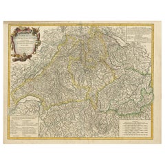
View AllAntique Map of Northern Switzerland by Janssonius
1657
By Johannes Janssonius
Located in Langweer, NL
Antique map 'Zurichgow et Basiliensis provincia'. Detailed map of northern Switzerland, including Zurich and Basel. This map originates from 'Atlas Novus, Sive Theatrum Orbis Orbis T...
Category
Antique Mid-17th Century Maps
Materials
Paper

Antique Map of Switzerland by Keizer
de Lat, 1788
Located in Langweer, NL
Antique map titled 'La Suisse (..)'. Uncommon original antique map of Switzerland. This map originates from 'Nieuwe Natuur- Geschied- en Handelkundige Zak- en Reisatlas' by Gerrit Br...
Category
Antique Late 18th Century Maps
Materials
Paper

$335 Sale Price
20% Off
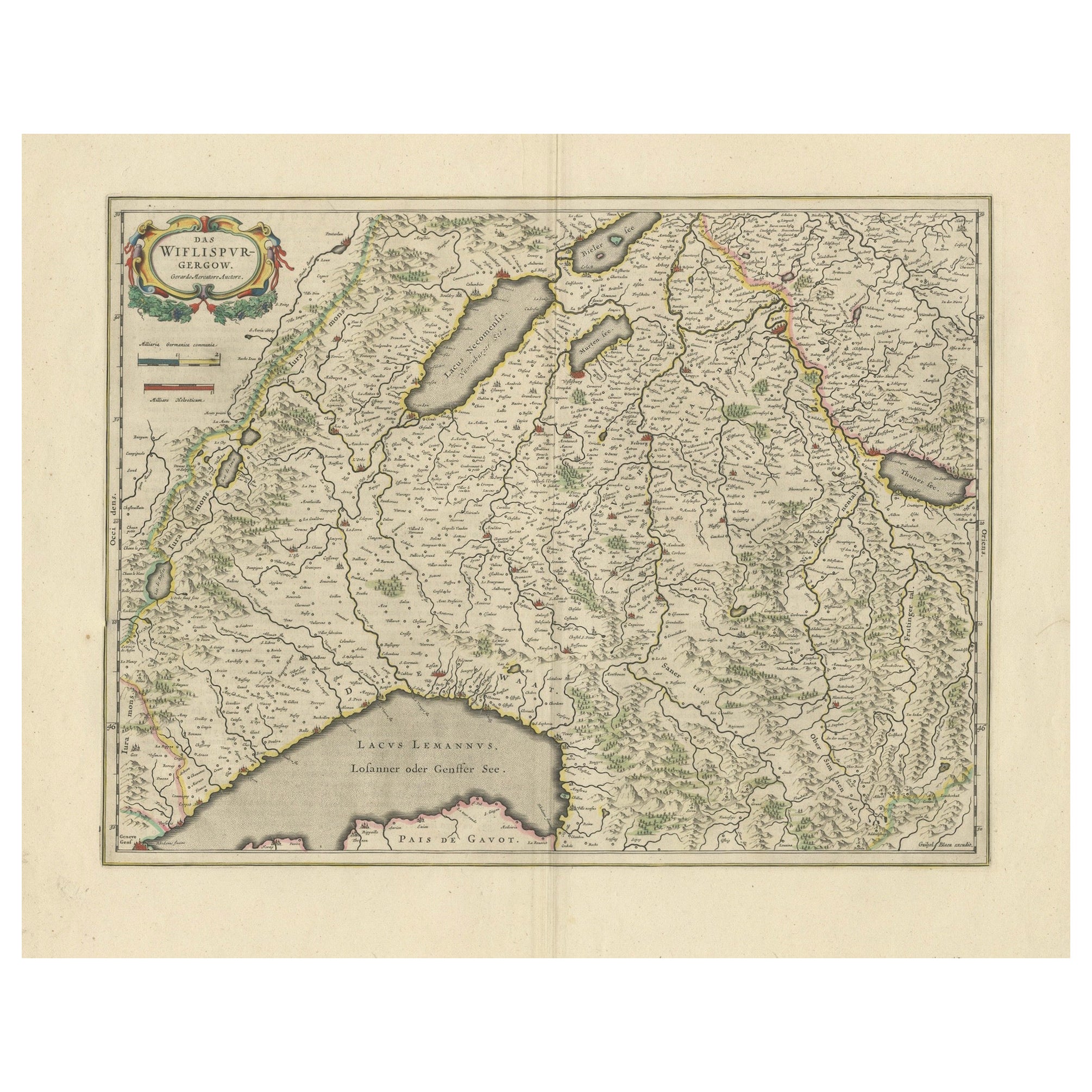
Circa 1659 Willem Blaeu Map: Southwestern Switzerland with Geneva
Lakes
Located in Langweer, NL
Circa 1659 Willem Blaeu Map: Southwestern Switzerland with Geneva & Lakes
This detailed map from circa 1659 by Willem Blaeu, titled "Das Wiflispurgergow," highlights the southwestern region of Switzerland.
It features significant landmarks such as Geneva, Lake Geneva (Lacus Lemannus), Lake Neuchatel, Lake Biel, Bern, Freiburg, and Lake Thuner.
Based on the work of Gerard Mercator, this map is published with Spanish text on the verso, dating from the period between 1659 and 1672.
Measuring 19.9 inches wide by 15.1 inches high, the map is rendered in full contemporary color on a bright sheet that bears a large watermark of the god Atlas.
The condition is excellent, with a sharp impression, short centerfold separations at the top and bottom margins, and an archivally repaired tear in the right margin.
Keywords:
- Willem Blaeu map
- Gerard Mercator
- 17th-century Switzerland map...
Category
Antique 1650s Maps
Materials
Paper
$1,188 Sale Price
20% Off
Physical
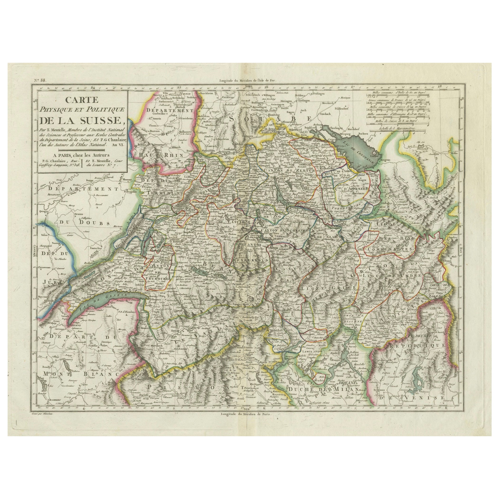
Political Map of Switzerland: Late 18th Century - Mentelle Atlas
Located in Langweer, NL
Antique Map with Title: 'Carte Physique et Politique de la Suisse'
**Publication Details:**
- **Atlas Title:** Nouvel Atlas Universel de Géographie Ancienne et Moderne
- **Purpose:...
Category
Antique 1790s Maps
Materials
Paper

$507 Sale Price
20% Off
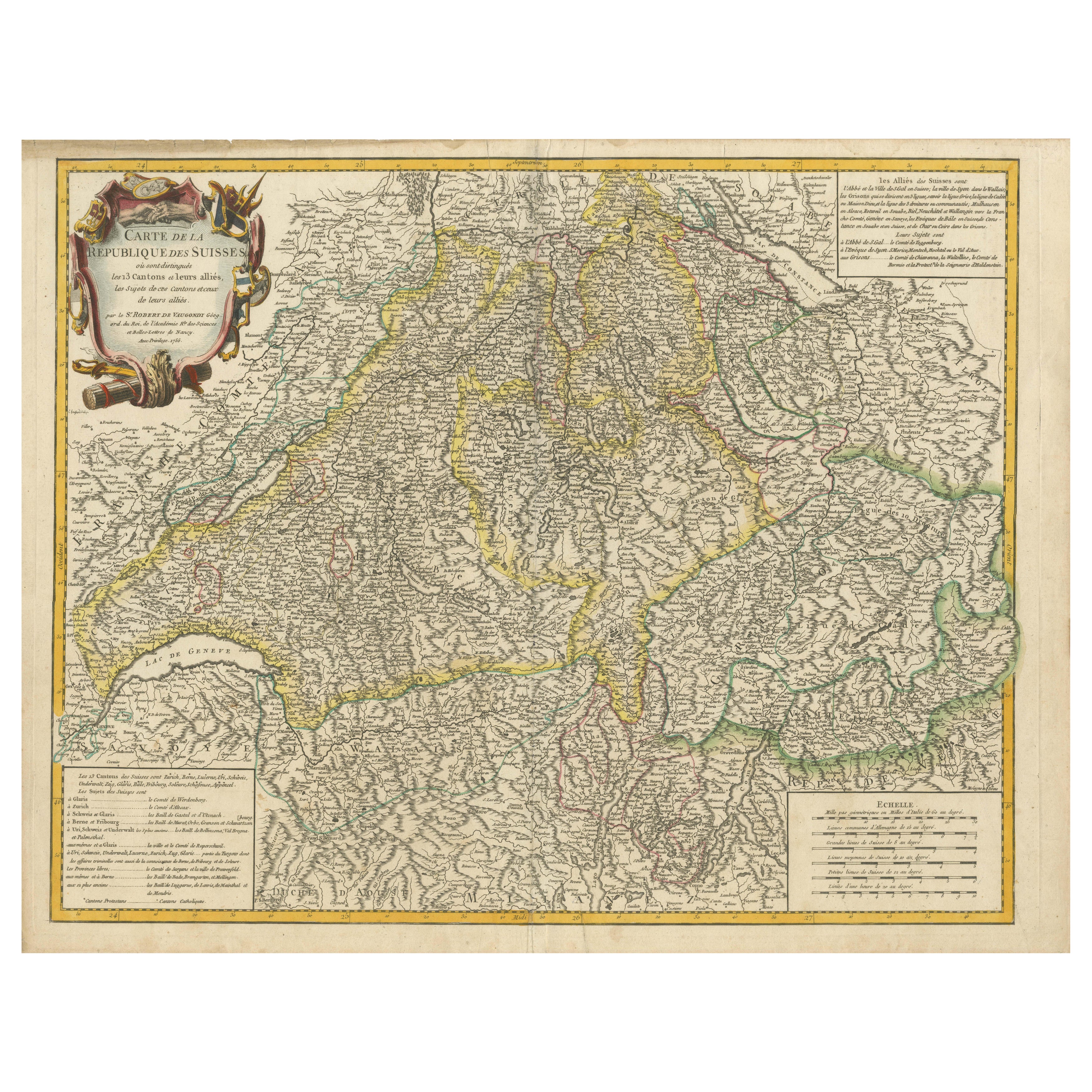
18th-Century Map of the Swiss Confederation by Robert de Vaugondy
Located in Langweer, NL
Title: 18th-Century Map of the Swiss Confederation by Robert de Vaugondy
Description: This detailed 18th-century map by Gilles Robert de Vaugondy presents the Swiss Confederation,...
Category
Antique 1750s Maps
Materials
Paper
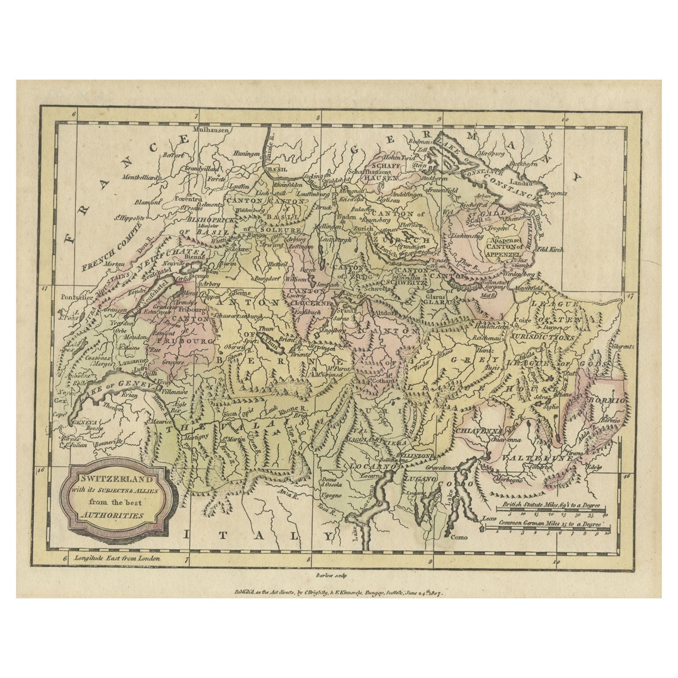
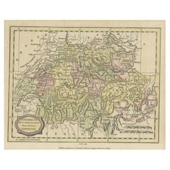
Small Original Antique Map of Switzerland and Surroundings, 1807
Located in Langweer, NL
Antique map titled 'Switzerland with its subjects & allies from the best authorities'.
Small map of Switzerland and surroundings. Originates from 'A general view of the world' by...
Category
Antique Early 1800s Maps
Materials
Paper
$124 Sale Price
20% Off
You May Also Like
Map of Switzerland - Etching - 19th Century
Located in Roma, IT
This map of Netherlands is an etching realized in 19th century.
The state of preservation of the artwork is excellent. The signature "F.B." is engraved on the lower right. At the to...
Category
19th Century Figurative Prints
Materials
Etching

1839 Map of Karte Des "Russischen Reiches in Europa Und Asien" Ric.R0013
Located in Norton, MA
1839 map of Karte Des
"Russischen Reiches in Europa and Asien"
Ric.r013
Map of the European and Asian parts of Russian Empire. Karte der Russischen Reiches in Europa und Asien...
Category
Antique 19th Century Unknown Maps
Materials
Paper

1752 Vaugoundy Map of Flanders : Belgium, France, and the Netherlands, Ric.a002
Located in Norton, MA
Large Vaugoundy Map of Flanders:
Belgium, France, and the Netherlands
Colored -1752
Ric.a002
Description: This is a 1752 Didier Robert de Vaugondy map of Flanders. The map de...
Category
Antique 17th Century Unknown Maps
Materials
Paper

1640 Joan Bleau Map Entitled"Diocecese de rheims et le pais de rethel, " Eic.a011
Located in Norton, MA
1640 Joan Bleau map entitled
"Diocecese de rheims et le pais de rethel,"
Ric.a011
OAN BLAEU
Diocecese de Rheims, et le pais de Rethel.
Handcolored engraving, c.1640.
...
Category
Antique 17th Century Dutch Maps
Materials
Paper

1640 Willem Blaeu Map Entitled "Contado di molise et principato vltra, " Ric.a003
By Willem Blaeu
Located in Norton, MA
1640 Willem Blaeu map entitled
"Contado di molise et principato vltra,"
Colored
Ric. a003
Measures: 38 x 49.6 cm and wide margins
DBLAEU.
Cou...
Category
Antique 17th Century Dutch Maps
Materials
Paper

1771 Bonne Map of Poitou, Touraine and Anjou, France, Ric.a015
Located in Norton, MA
1771 Bonne Map of Poitou,
Touraine and Anjou, France
Ric.a015
1771 Bonne map of Potiou, Touraine and Anjou entitled "Carte des Gouvernements D'Anjou et du Saumurois, de la Touraine, du Poitou,du Pays d'aunis, Saintonge?Angoumois,"
Carte des gouvernements d'Anjou et du Saumurois, de la Touraine, du Poitou, du Pays d'Aunis, Saintonge-Angoumois. Projettee et assujettie au ciel par M. Bonne, Hyd. du Roi. A Paris, Chez Lattre, rue St. Jacques a la Ville de Bord(ea)ux. Avec priv. du Roi. 1771. Arrivet inv. & sculp., Atlas moderne ou collection de cartes sur toutes...
Category
Antique 17th Century Unknown Maps
Materials
Paper

More Ways To Browse
18th Century Engravings
Antique Carved Wood Chair
Black Scandinavian Modern Dining Chairs
Dutch Mid Century Modern Table
Gold Modern Coffee Table
Iconic Modern Furniture
Midcentury Modern Gray Glass Vase
Round Glass Coffee Tables
Vintage Cave
18th Century Wood Side Tables
Antique Hand Carved Dining Room Sets
Mid Century Modern Pitcher
Vintage Italian Leather Dining Chair
Vintage Movie Posters
Blue Green Wool And Silk Rug
Brown Sheepskin Chair
Vintage Brass Bar Carts
Antique Botanical Prints