Items Similar to Map of the Pacific Ocean and Philippine Archipelago – Manila Observatory, 1899
Want more images or videos?
Request additional images or videos from the seller
1 of 9
Map of the Pacific Ocean and Philippine Archipelago – Manila Observatory, 1899
$524.30
£390.53
€440
CA$722.01
A$785.88
CHF 416.41
MX$9,451.46
NOK 5,294.58
SEK 4,851.89
DKK 3,352.51
About the Item
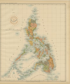
Title: Pacific Ocean and the Philippine Archipelago – Observatorio de Manila, 1899
Description:
This finely detailed chromolithographed map titled “Islas Filipinas – Océano Pacífico” was produced in 1899 under the direction of Rev. José Algué, S.J., Director of the Observatorio de Manila. Issued as Plate No. 1 from the Atlas de Filipinas, this important work formed the basis for the later U.S. Coast and Geodetic Survey’s Atlas of the Philippine Islands (Washington, 1900).
The map shows the Pacific Ocean in exceptional geographic scope, extending from the eastern coast of Asia—including Manchuria, Japan, Korea, and the Philippines—across the Pacific islands to Hawaii and the western coast of North America, including Alaska, California, and Mexico. The map also includes Australia, New Zealand, and the Indonesian archipelago, situating the Philippines at the center of the Pacific world.
Printed in subtle color tones with fine typographic precision, this map bears the official embossed seal of the U.S. Coast and Geodetic Survey and the stamp of the Observatorio de Manila, confirming its authenticity and publication during the crucial transition from Spanish to American administration in the Philippines.
The map provides valuable historical insight into the late 19th-century understanding of Pacific geography, maritime routes, and territorial divisions before the advent of modern cartographic projection. It also represents the remarkable collaboration between Filipino draftsmen and Jesuit scientists whose pioneering work contributed significantly to the modernization of Philippine cartography.
Condition: Excellent, with original color, minimal toning, and clean margins. Embossed survey seal visible in the lower right corner.
Framing tips: Best presented in a dark wooden or gilt frame with a light ivory mat to emphasize the soft pastel hues and maritime detail.
Technique: Chromolithograph on paper
Maker: Rev. José Algué, S.J., Observatorio de Manila, 1899
- Dimensions:Height: 12.8 in (32.5 cm)Width: 14.57 in (37 cm)Depth: 0.01 in (0.2 mm)
- Materials and Techniques:
- Place of Origin:
- Period:
- Date of Manufacture:1899
- Condition:Condition: Excellent, with original color, minimal toning, and clean margins. Embossed survey seal visible in the lower right corner.
- Seller Location:Langweer, NL
- Reference Number:Seller: BG-12176-11stDibs: LU3054346956162
About the Seller
5.0
Recognized Seller
These prestigious sellers are industry leaders and represent the highest echelon for item quality and design.
Platinum Seller
Premium sellers with a 4.7+ rating and 24-hour response times
Established in 2009
1stDibs seller since 2017
2,824 sales on 1stDibs
Typical response time: 1 hour
- ShippingRetrieving quote...Shipping from: Langweer, Netherlands
- Return Policy
More From This Seller
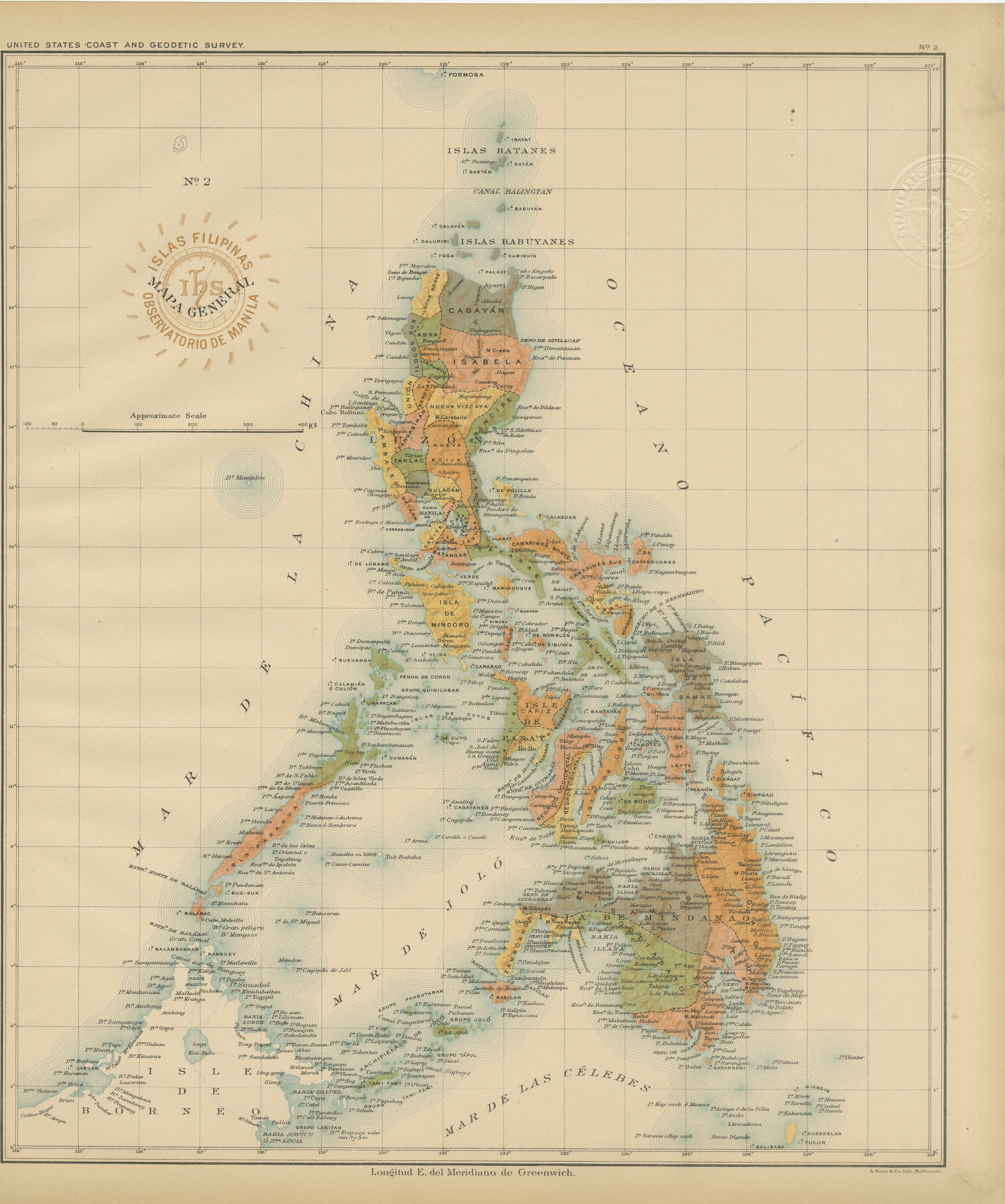
View AllAntique Map of the Philippine Islands – Observatorio de Manila, 1899
Located in Langweer, NL
Antique Map of the Philippine Islands – Observatorio de Manila, 1899
This beautiful chromolithographed map titled “Islas Filipinas” was created in 1899 under the direction of Rev. J...
Category
Antique 1890s Philippine Maps
Materials
Paper
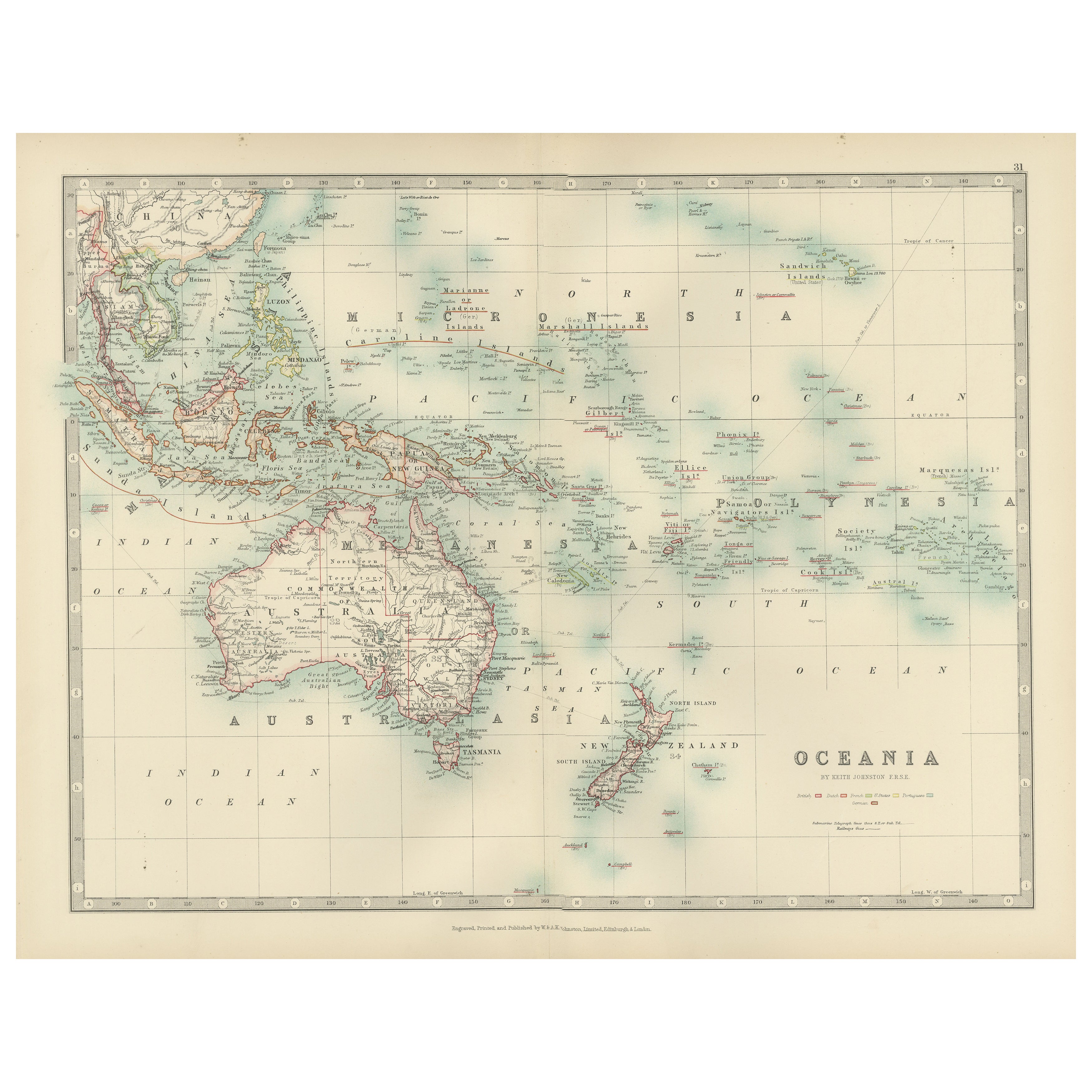
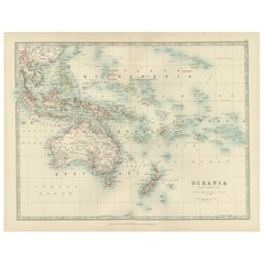
Antique Map of Oceania, 1903, Featuring the Pacific Islands and Australasia
Located in Langweer, NL
Title: Antique Map of Oceania, 1903, Featuring the Pacific Islands and Australasian Region
Description:
This antique map, titled "Oceania," was engraved and published in 1903 by W. ...
Category
Early 20th Century Maps
Materials
Paper
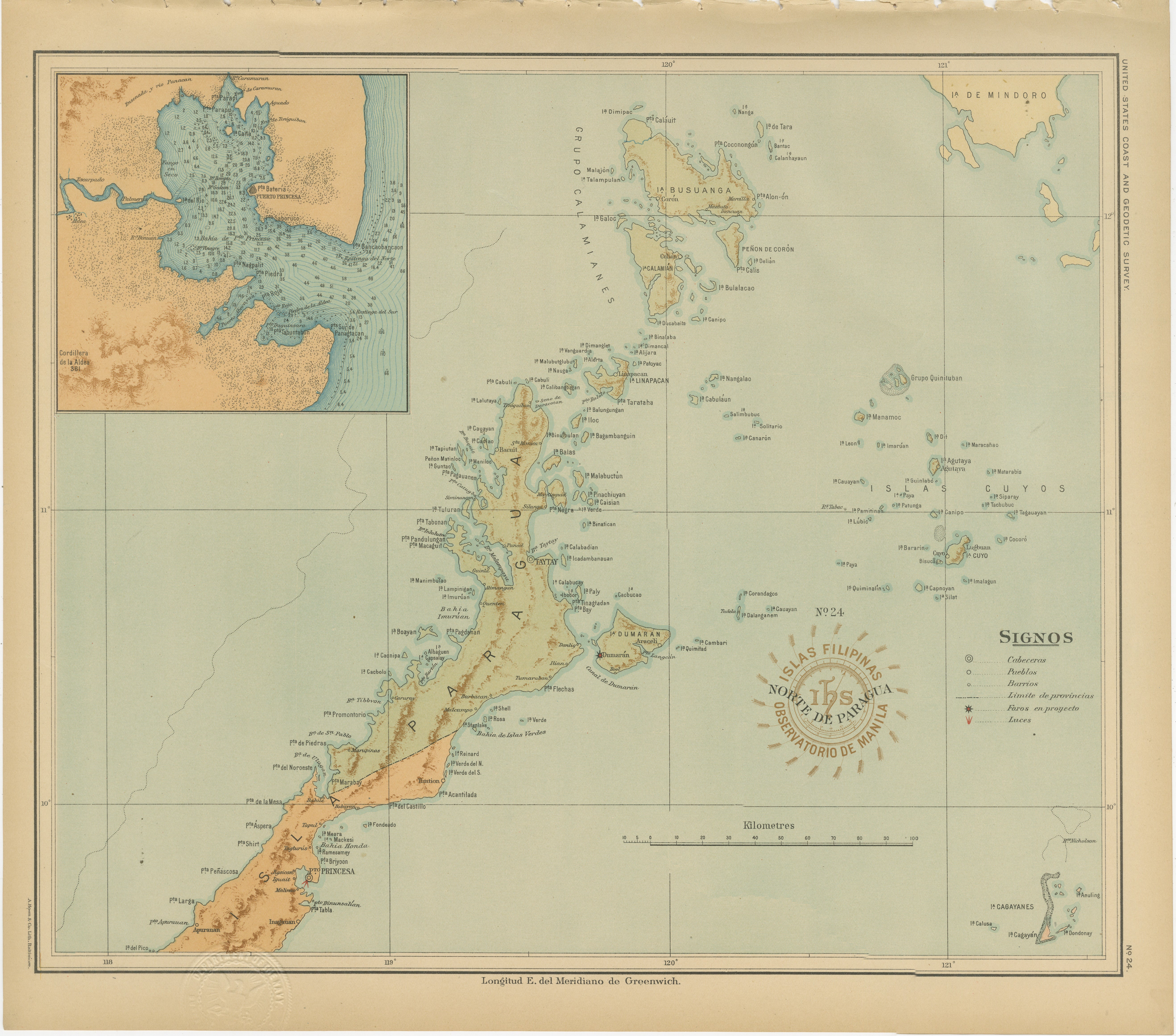
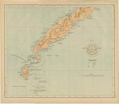
Map of the Northern Part of Palawan – Observatorio de Manila, 1899
Located in Langweer, NL
Title: Map of the Northern Part of Palawan – Observatorio de Manila, 1899
This finely detailed chromolithograph titled “Islas Filipinas – Norte de Paragua” depicts the northern regi...
Category
Antique 1890s Philippine Maps
Materials
Paper
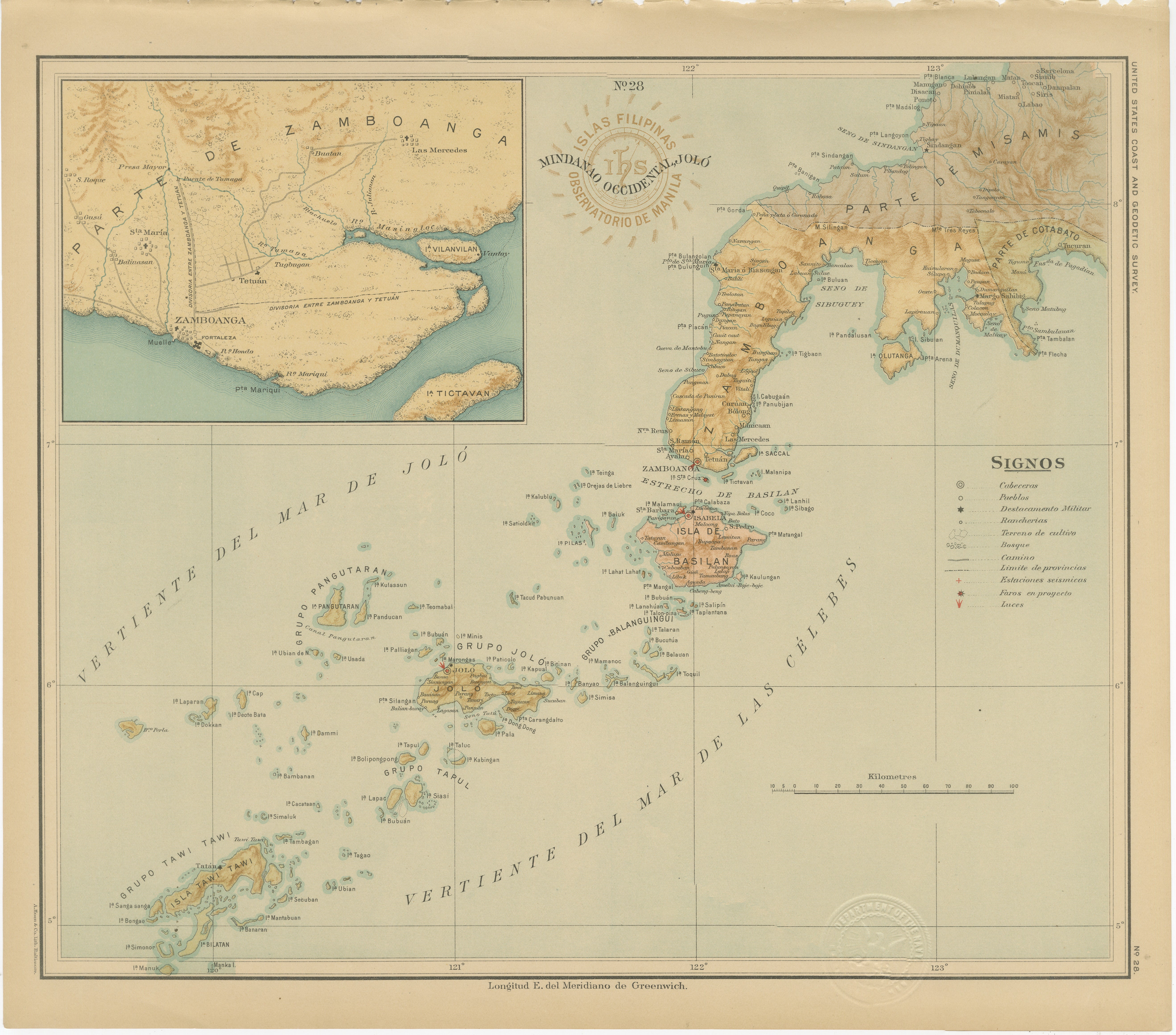
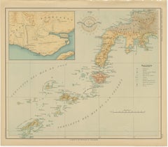
Map of Western Mindanao and the Sulu Archipelago – Observatorio de Manila, 1899
Located in Langweer, NL
Map of Western Mindanao and the Sulu Archipelago – Observatorio de Manila, 1899
This original chromolithographed map titled “Islas Filipinas – Mindanao Occidental y Joló” (Plate No....
Category
Antique 1890s Philippine Maps
Materials
Paper
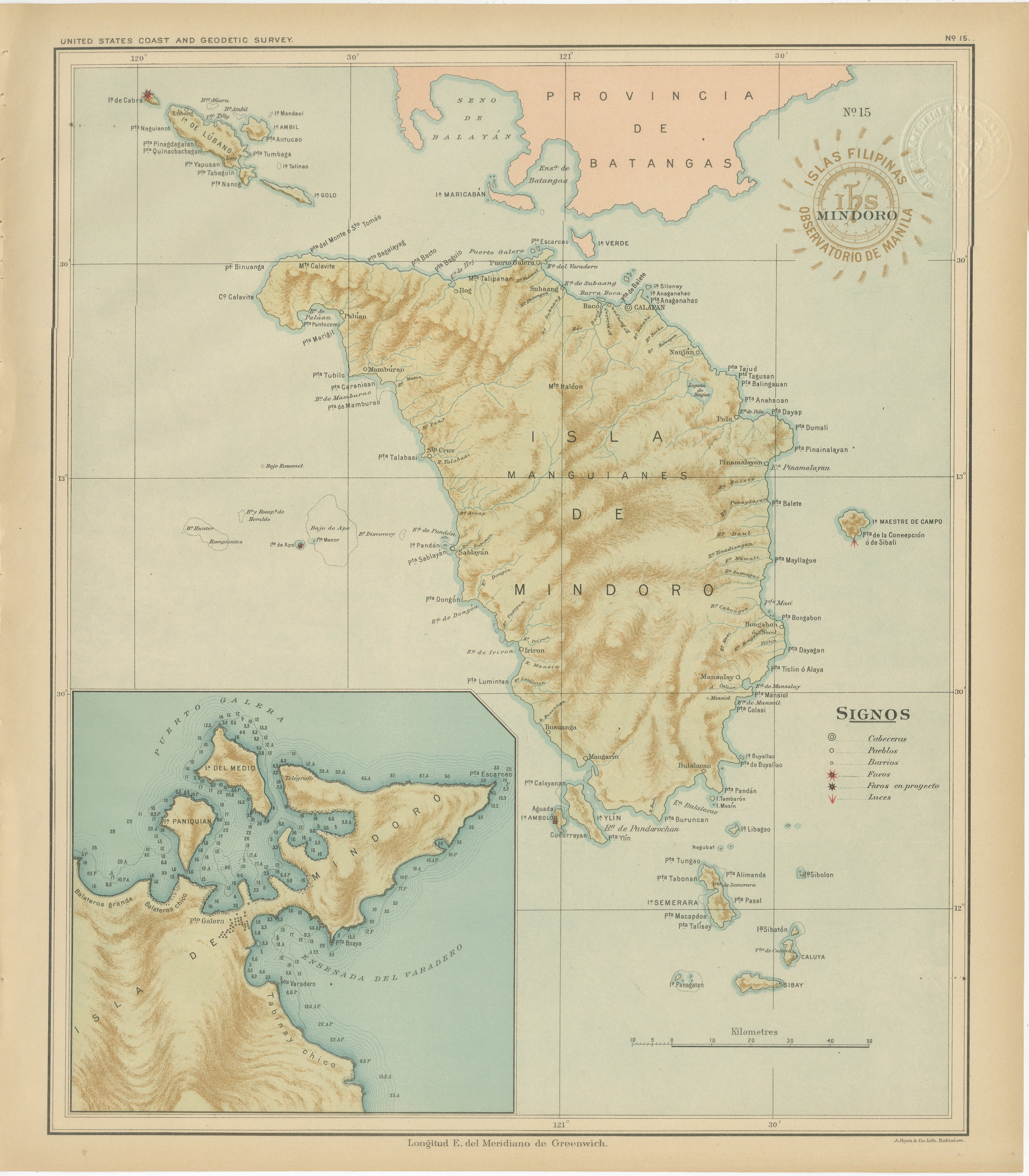
Map of the Island of Mindoro – Observatorio de Manila, 1899
Located in Langweer, NL
Title: Map of the Island of Mindoro – Observatorio de Manila, 1899
Description:
This finely executed chromolithographed map titled “Islas Filipinas – Isla de Mindoro” was published ...
Category
Antique 1890s Philippine Maps
Materials
Paper

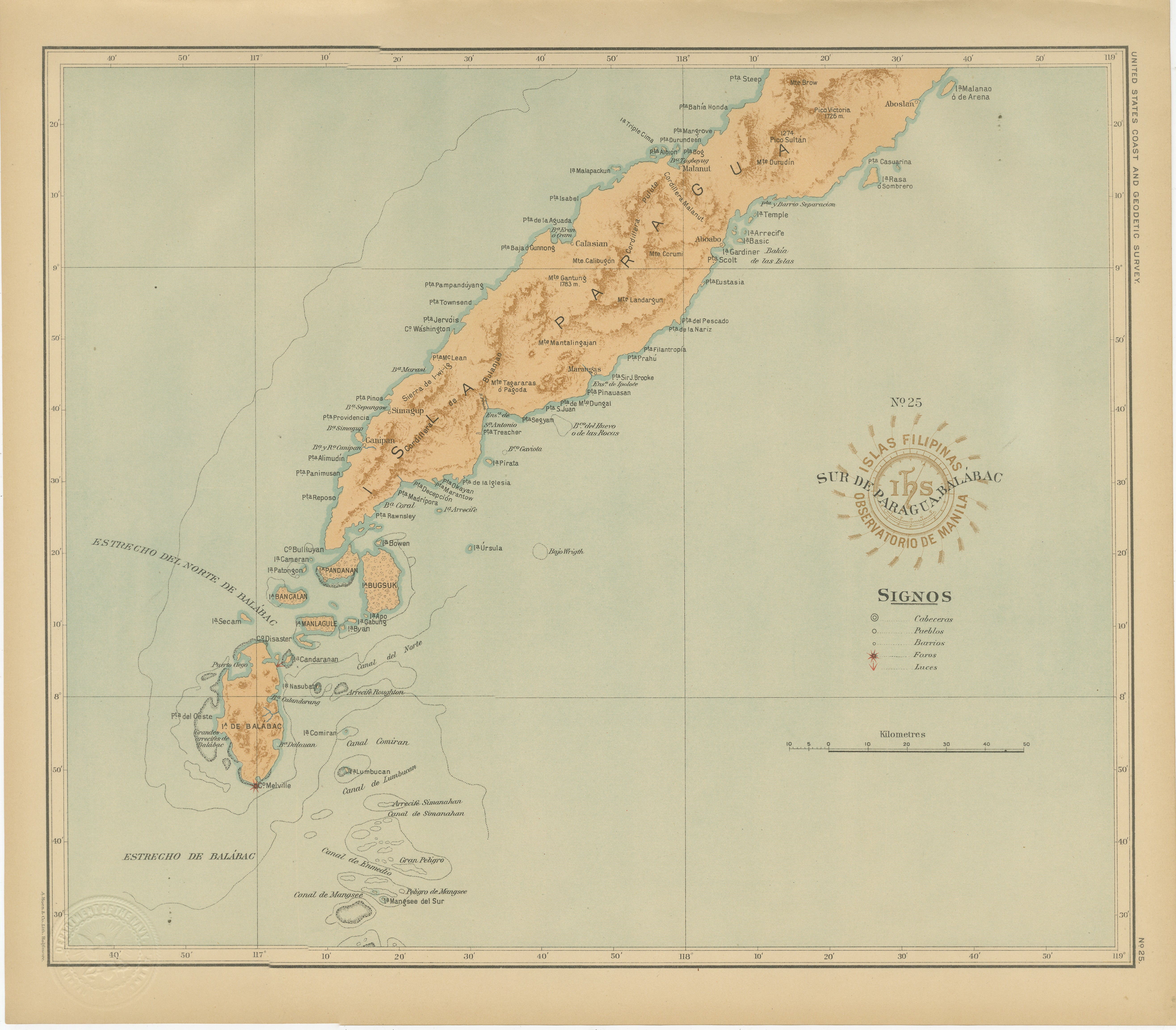
Map of Southern Palawan and the Balabac Islands – Observatorio de Manila, 1899
Located in Langweer, NL
Map of Southern Palawan and the Balabac Islands – Observatorio de Manila, 1899
This original chromolithograph titled “Islas Filipinas – Sur de Paragua y Balabac” was produced under ...
Category
Antique 1890s Philippine Maps
Materials
Paper
You May Also Like
Large Original Antique Map of The Pacific Ocean, Fullarton, C.1870
Located in St Annes, Lancashire
Great map of The Pacific Ocean
From the celebrated Royal Illustrated Atlas
Lithograph by Swanston. Original color.
Published by Fullarton,...
Category
Antique 1870s Scottish Maps
Materials
Paper

Original Antique Map of The Philippines. C.1900
Located in St Annes, Lancashire
Fabulous map of The Philippines
Original color.
Engraved and printed by the George F. Cram Company, Indianapolis.
Published, C.1900.
Unframed.
Free shipping.
Category
Antique 1890s American Maps
Materials
Paper

Original Antique Map of US Possessions In The Pacific Ocean, C.1900
Located in St Annes, Lancashire
Fabulous map of US possessions in the Pacific Ocean
Original color.
Engraved and printed by the George F. Cram Company, Indianapolis.
Published, C.1900.
Unframed.
Free shipping.
Category
Antique 1890s American Maps
Materials
Paper

Ancient Map of Oceania - Original Etching - 19th century
Located in Roma, IT
This Map of Oceania is an etching realized in the 19th century.
The state of preservation of the artwork is good. At the top of the paper, the inscription “Longitudine del Meridiano...
Category
19th Century More Prints
Materials
Etching

Large Original Vintage Map of The Pacific Islands Including Hawaii
Located in St Annes, Lancashire
Great map of The Pacific Islands
Unframed
Original color
By John Bartholomew and Co. Edinburgh Geographical Institute
Published, circa 1...
Category
Vintage 1920s British Maps
Materials
Paper

Original Antique Map of The Eastern Hemisphere by Dower, circa 1835
Located in St Annes, Lancashire
Nice map of the Eastern Hemisphere
Drawn and engraved by J.Dower
Published by Orr & Smith. C.1835
Unframed.
Free shipping
Category
Antique 1830s English Maps
Materials
Paper
