Items Similar to Map of Polynesia Highlighting Cultural Landscapes and Maritime Activities, 1851


Want more images or videos?
Request additional images or videos from the seller
1 of 6
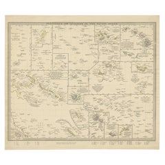
Map of Polynesia Highlighting Cultural Landscapes and Maritime Activities, 1851
$278.39
$347.9920% Off
£206.30
£257.8820% Off
€232
€29020% Off
CA$380.48
CA$475.6020% Off
A$414.18
A$517.7320% Off
CHF 219.85
CHF 274.8120% Off
MX$4,983.49
MX$6,229.3620% Off
NOK 2,785.77
NOK 3,482.2120% Off
SEK 2,552.55
SEK 3,190.6920% Off
DKK 1,767.21
DKK 2,209.0220% Off
About the Item
John Tallis
Company was a London-based map publisher that flourished during the 19th century. Their maps, characterized by elaborate borders and decorative vignettes, are some of the last examples of large-scale decorative cartography before the trend moved towards more utilitarian and scientific mapping.
The Tallis map of Polynesia is a fine example of their work. It would likely depict the many islands spread across the central and southern Pacific Ocean, an area often referred to as Polynesia. The map probably emphasizes not only the geography but also the cultural and natural history of the region through its detailed vignettes.
Robert Montgomery Martin's involvement would suggest that the map contains explanatory text providing context about the British presence and interests in the region, reflecting the broader imperial narrative of the time.
The countries and territories within Polynesia would include a wide range of island groups, many of which had significant cultural ties but were colonially influenced by different European powers, including the British. Strategic locations for trade and military outposts would be highlighted.
The Tallis series of maps are important historical documents that capture a world in transition, showing how the British saw their empire and its global context. These maps remain valuable for their rich artistic detail and as artifacts of the Victorian era's cultural and political milieu.
The images on the map in more detail:
The images in the insets of the Tallis map of Polynesia seem to depict various cultural and natural scenes relevant to the region, emphasizing the beauty and uniqueness of the places and the people who inhabit them.
1. **Resolution Bay, Marquesas**: This inset likely depicts a scene from Resolution Bay in the Marquesas Islands. It shows a traditional boat with what appears to be a group of local Polynesians in traditional attire navigating the waters with a mountainous backdrop, indicative of the volcanic origins of many islands in the region.
2. **Otahiete (Tahiti)**: Featuring traditional Polynesian canoes with a distinctive sail, possibly in the waters of Tahiti, known locally as Otahiti. This might capture a moment of daily life or transport methods, with thatched structures on the water's edge and the lush, mountainous landscapes that are characteristic of the island.
3. **Harbour of Dory, New Guinea**: This scene likely illustrates a harbor in New Guinea, with more rudimentary and utilitarian canoes shown. The background may show a European vessel, indicating contact or trade with outsiders, set against a vista of the rugged, densely vegetated coastline.
4. **Kalakakooa, Sandwich Islands (Hawaii)**: The image probably shows Kalakakooa (Kealakekua Bay) on the Island of Hawaii, also known as the Sandwich Islands at that time. It was famous for being the place where British explorer Captain James Cook was killed in 1779. This depiction emphasizes the interaction between the local people and European explorers or traders.
These detailed engravings are typical of the Tallis style, aiming to provide not only geographical information but also a sense of the life, environment, and interactions taking place in the depicted regions. They also reflect the European interest in and romanticization of "exotic" locales during the era of colonial expansion.
- Dimensions:Height: 10.71 in (27.2 cm)Width: 14.26 in (36.2 cm)Depth: 0 in (0.02 mm)
- Materials and Techniques:
- Period:
- Date of Manufacture:1851
- Condition:Good given age. Original fold in middle as published. General age-related toning, please study scan carefully.
- Seller Location:Langweer, NL
- Reference Number:Seller: BG-13736-101stDibs: LU3054339296802
About the Seller
5.0
Recognized Seller
These prestigious sellers are industry leaders and represent the highest echelon for item quality and design.
Platinum Seller
Premium sellers with a 4.7+ rating and 24-hour response times
Established in 2009
1stDibs seller since 2017
2,819 sales on 1stDibs
Typical response time: 1 hour
- ShippingRetrieving quote...Shipping from: Langweer, Netherlands
- Return Policy
More From This Seller
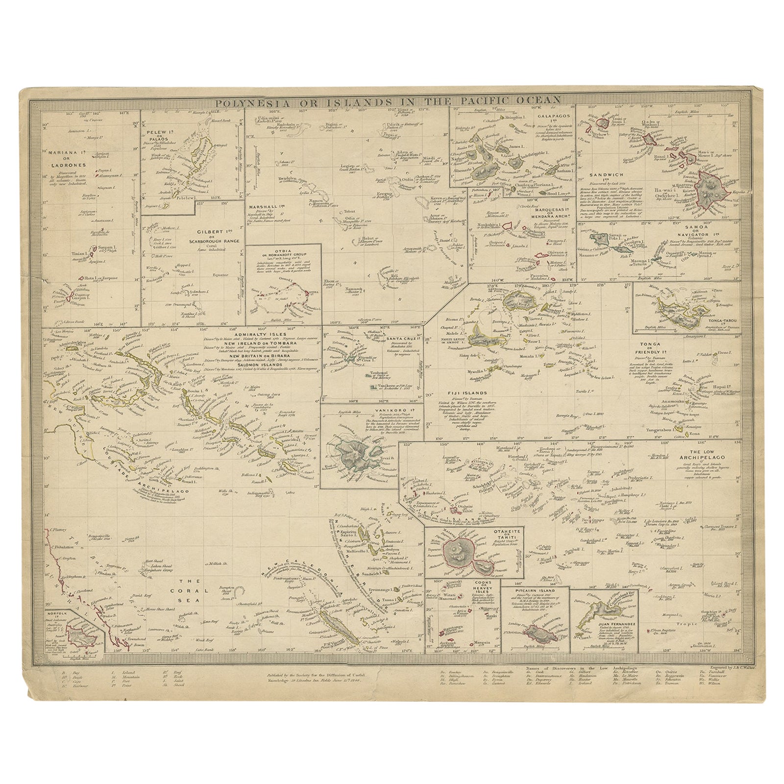
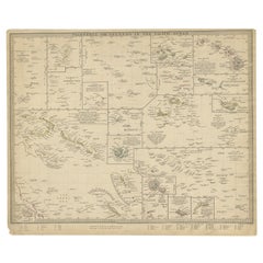
View AllAntique Map of Polynesia by Walker, 1840
Located in Langweer, NL
Antique map titled 'Polynesia or Islands in the Pacific Ocean'. This map depicts various islands including the Lousiade Archipelago, Tahiti, Pitcairn Island, Juan Fernandez, The low ...
Category
Antique 19th Century Maps
Materials
Paper
Antique Map of Western Polynesia, 1849
Located in Langweer, NL
Antique map titled 'Ost-Polynesien'. Detailed map of the western Pacific extending from the Celebes to Samoa and including part of Australia. Insets of...
Category
Antique Mid-19th Century Maps
Materials
Paper

$167 Sale Price
30% Off
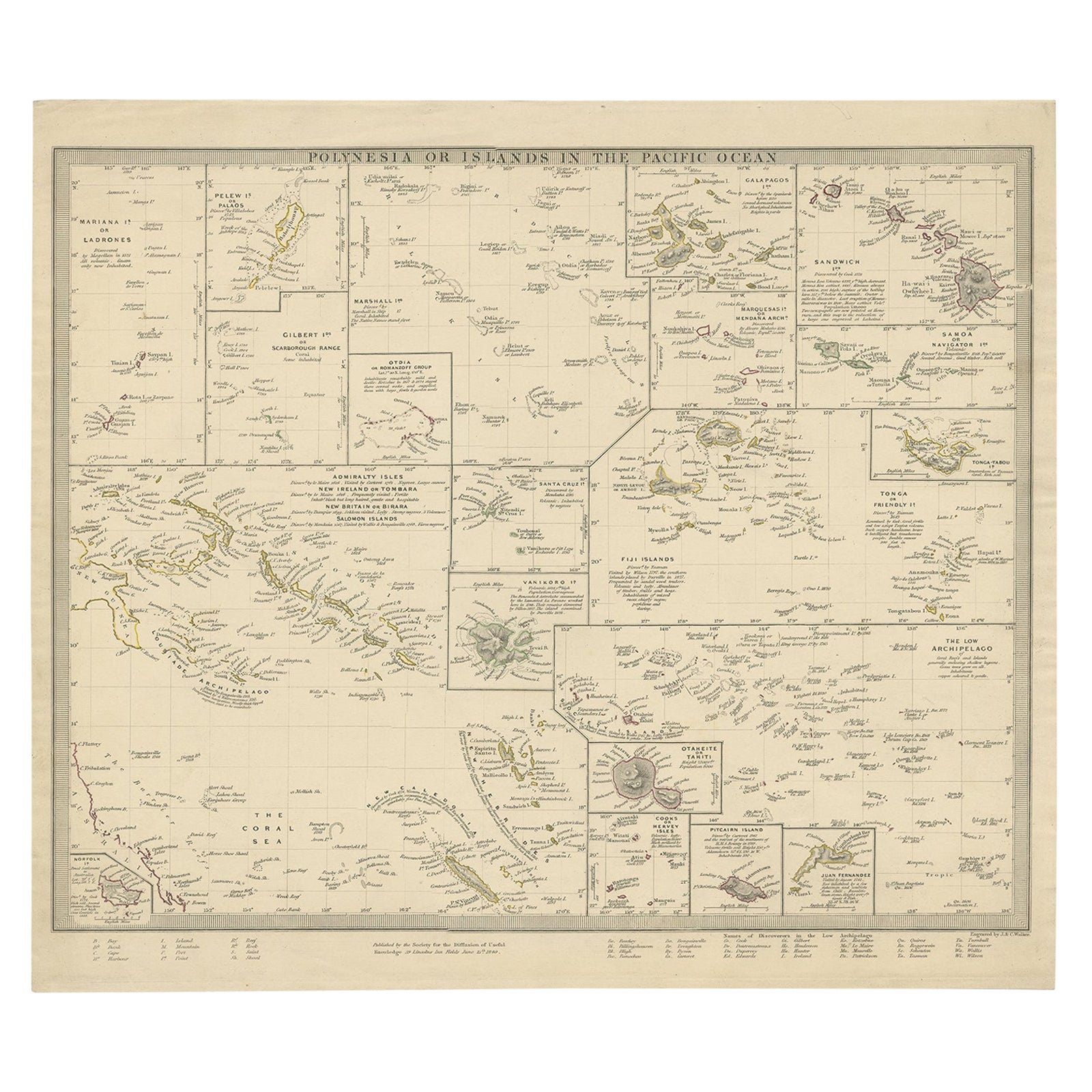
Antique Map of Polynesia with Details of Many Islands, 1840
Located in Langweer, NL
Antique map titled 'Polynesia or Islands in the Pacific Ocean'.
This map depicts various islands including the Lousiade Archipelago, Tahiti, Pitcairn Island, Juan Fernandez, The lo...
Category
Antique 19th Century Maps
Materials
Paper
Antique Map of Polynesia and Australasia by Neele, 1825
Located in Langweer, NL
Antique map titled 'Polynesia and Australasia'. It shows Australia (New Holland), part of Asia, New Zealand and many islands. This map originates from 'Encyclopedia Londinensis'.
Category
Antique Early 19th Century Maps
Materials
Paper

Antique Map of Eastern Polynesia, 1849
Located in Langweer, NL
Antique map titled 'Ost-Polynesien'. Interesting variant issue, with large detailed insets top right of Hawaii volcanos near Kilauea. Insets lower right of Honolulu harbour, island o...
Category
Antique Mid-19th Century Maps
Materials
Paper

$167 Sale Price
30% Off
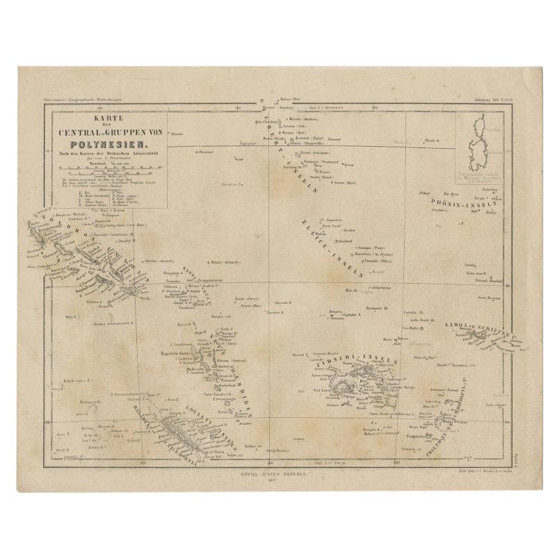
Old German Map Depicting the Central Islands of Polynesia, 1857
Located in Langweer, NL
Antique map Polynesia titled 'Karte der Central-Gruppen von Polynesien'. Old map depicting the central islands of Polynesia. This map originates from 'Petermanns Geographische Mittei...
Category
Antique 19th Century Maps
Materials
Paper
You May Also Like
Large Original Antique Map of The Pacific Ocean, Fullarton, C.1870
Located in St Annes, Lancashire
Great map of The Pacific Ocean
From the celebrated Royal Illustrated Atlas
Lithograph by Swanston. Original color.
Published by Fullarton,...
Category
Antique 1870s Scottish Maps
Materials
Paper

Large Original Vintage Map of The Pacific Islands Including Hawaii
Located in St Annes, Lancashire
Great map of The Pacific Islands
Unframed
Original color
By John Bartholomew and Co. Edinburgh Geographical Institute
Published, circa 1...
Category
Vintage 1920s British Maps
Materials
Paper

Ancient Map of Oceania - Original Etching - 19th century
Located in Roma, IT
This Map of Oceania is an etching realized in the 19th century.
The state of preservation of the artwork is good. At the top of the paper, the inscription “Longitudine del Meridiano...
Category
19th Century More Prints
Materials
Etching

Original Antique Map of Hawaii And Adjacent Islands. C.1900
Located in St Annes, Lancashire
Fabulous map of Hawaii. With a vignette of Honolulu
Original color.
Engraved and printed by the George F. Cram Company, Indianapolis.
Published, C.1900.
Unframed.
Free shipping.
Category
Antique 1890s American Maps
Materials
Paper

Large Original Antique Map of The Leeward Islands. 1894
Located in St Annes, Lancashire
Superb Antique map of The Leeward Islands
Published Edward Stanford, Charing Cross, London 1894
Original colour
Good condition
Unframed.
Free shipping
Category
Antique 1890s English Maps
Materials
Paper

Original Antique Map of US Possessions In The Pacific Ocean, C.1900
Located in St Annes, Lancashire
Fabulous map of US possessions in the Pacific Ocean
Original color.
Engraved and printed by the George F. Cram Company, Indianapolis.
Published, C.1900.
Unframed.
Free shipping.
Category
Antique 1890s American Maps
Materials
Paper

More Ways To Browse
Hawaiian Antique
Antique Canoe
Sandwich Islands
Pair Arm Chairs
Sterling Silver Dinner Sets
United Chair Company
Italian Beech Chairs
Shirvan Rugs
Vintage Danish Tables And Chairs
1960s Glass Top Coffee Table
Black Glass Coffee Tables
Burnt Wood
Mid Century Wrought Iron Chairs
Earth Toned Rug
Black Marble Table Vintage
Goblets
Mid Century Modern Yellow Chair
Paulin Pierre