Items Similar to Map of the San Juanico Strait between Leyte and Samar – 1899
Want more images or videos?
Request additional images or videos from the seller
1 of 9
Map of the San Juanico Strait between Leyte and Samar – 1899
$275.50
£206.01
€230
CA$379.57
A$413.98
CHF 219.30
MX$4,963.01
NOK 2,792.88
SEK 2,553.88
DKK 1,752.69
About the Item
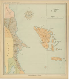
Map of the San Juanico Strait between Leyte and Samar – Observatorio de Manila, 1899
This original chromolithograph titled “Islas Filipinas – Estrecho de San Juanico” (Plate No. 30) was prepared under the direction of Rev. José Algué, S.J., Director of the Observatorio de Manila, and published in 1899 as part of the Atlas de Filipinas. It presents a superbly detailed chart of the narrow and winding San Juanico Strait, separating the islands of Leyte and Samar in the central Philippines.
The map focuses on one of the most distinctive maritime passages in the archipelago — a channel known for its treacherous currents and scenic beauty. The engraving shows the soundings, coastal contours, and numerous small islets that line the strait, reflecting its importance for 19th-century navigation and hydrographic study. Surrounding terrain is carefully shaded in warm brown tones to indicate elevation, while the pale blue waters are dotted with depth measurements, sandbanks, and coral indications.
Major coastal settlements such as Tacloban, Basey, and Babatngon are identified, along with nearby bays including the “Bahía de San Pedro y San Pablo.” The map’s fine balance between artistic rendering and scientific accuracy demonstrates the Jesuit cartographers’ mastery of both disciplines.
A bold circular brown stamp of the “Observatorio de Manila” appears near the lower left corner, complemented by the blind-embossed seal of the “U.S. Coast and Geodetic Survey” — evidence of its inclusion in the Atlas of the Philippine Islands printed by the U.S. Government Printing Office in Washington in 1900. Together, these marks attest to the transition of Philippine cartography from Spanish to American oversight at the turn of the century.
Condition: Excellent, with strong original color and crisp detail. Very light age toning at the outer margin and minor handling signs; embossed and printed seals remain clear and well defined.
Framing tips: This chart’s soft maritime palette and elegant typography pair beautifully with a light oak or maple frame. A pale blue or cream mat will enhance the nautical theme, especially when displayed alongside the companion maps of Leyte and Samar.
Technique: Chromolithograph on paper
Maker: Rev. José Algué, S.J., Observatorio de Manila, 1899
- Dimensions:Height: 12.8 in (32.5 cm)Width: 14.57 in (37 cm)Depth: 0.01 in (0.2 mm)
- Materials and Techniques:
- Place of Origin:
- Period:
- Date of Manufacture:1899
- Condition:Condition: Excellent, with strong original color and crisp detail. Very light age toning at the outer margin and minor handling signs; embossed and printed seals remain clear and well defined.
- Seller Location:Langweer, NL
- Reference Number:Seller: BG-12176-301stDibs: LU3054346962612
About the Seller
5.0
Recognized Seller
These prestigious sellers are industry leaders and represent the highest echelon for item quality and design.
Platinum Seller
Premium sellers with a 4.7+ rating and 24-hour response times
Established in 2009
1stDibs seller since 2017
2,791 sales on 1stDibs
Typical response time: <1 hour
- ShippingRetrieving quote...Shipping from: Langweer, Netherlands
- Return Policy
More From This Seller
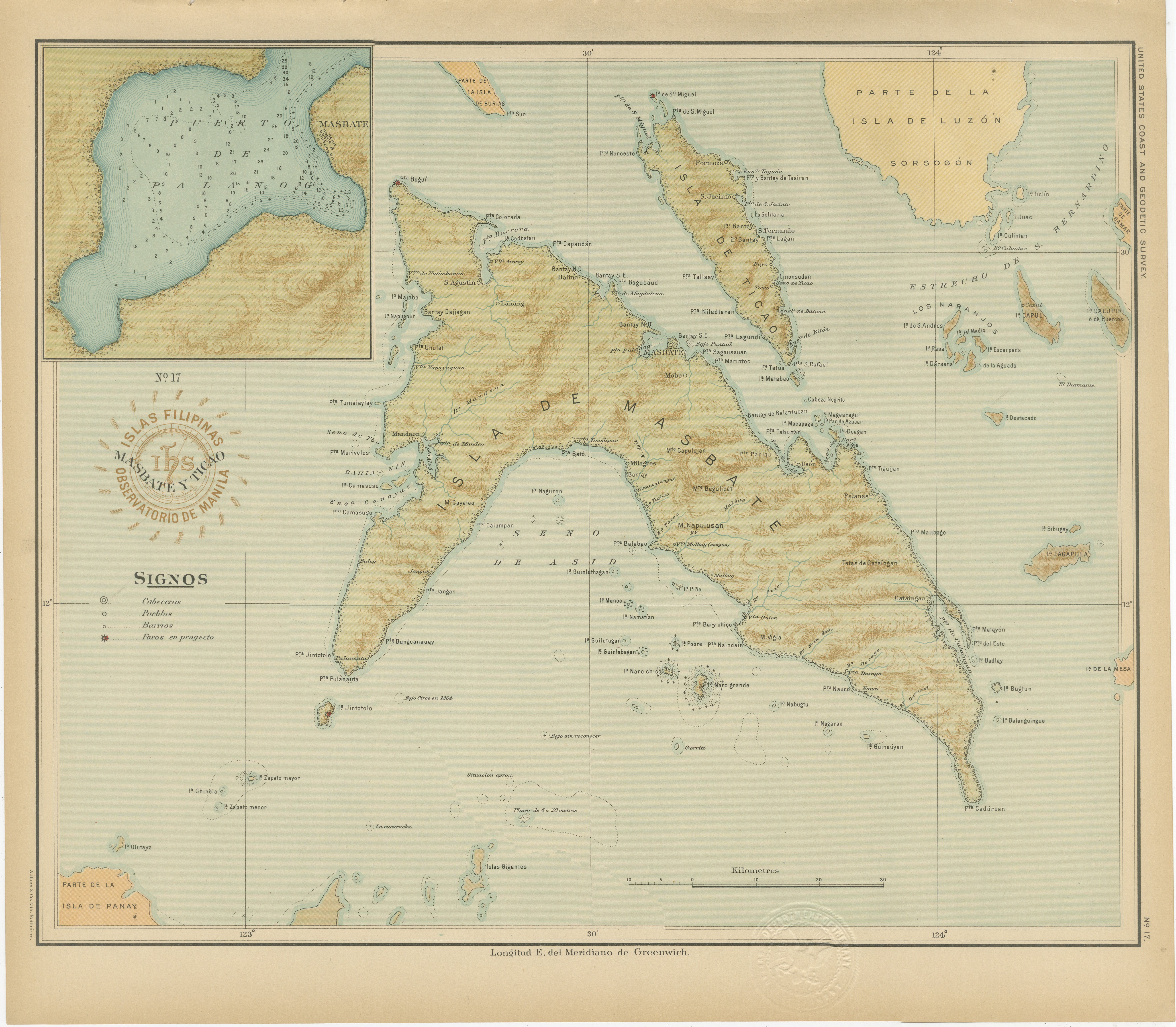
View AllMap of Masbate and Ticao Islands – Observatorio de Manila, 1899
Located in Langweer, NL
Map of Masbate and Ticao Islands – Observatorio de Manila, 1899
This elegant chromolithographed map titled “Islas Filipinas – Masbate y Ticao” was created under the supervision of R...
Category
Antique 1890s Philippine Maps
Materials
Paper
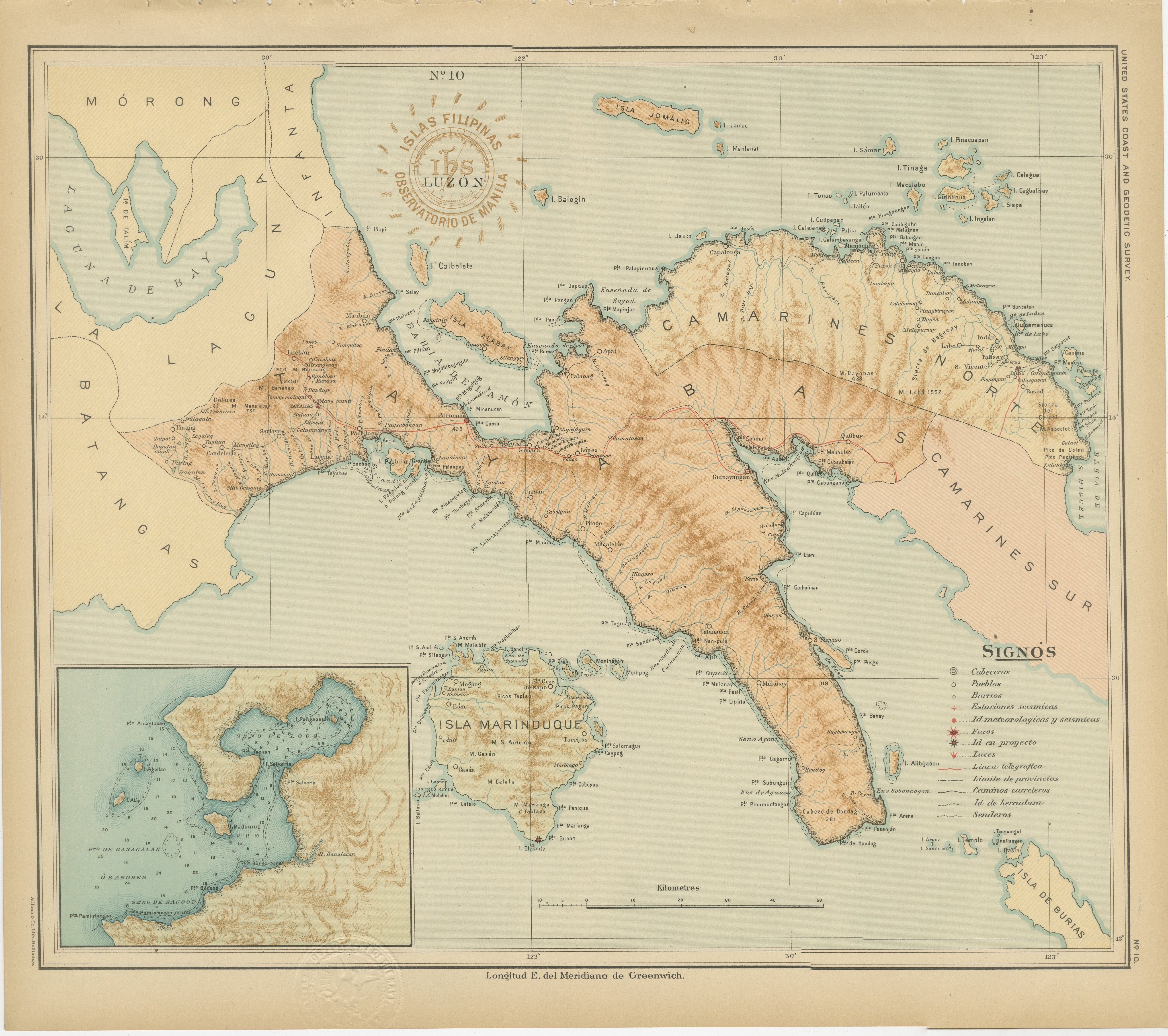
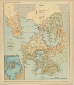
Map of Southern Luzon and Camarines Provinces – Observatorio de Manila, 1899
Located in Langweer, NL
Title: Map of Southern Luzon and Camarines Provinces – Observatorio de Manila, 1899
Description:
This chromolithographed map titled “Islas Filipinas – Luzón” was published in 1899 u...
Category
Antique 1890s Philippine Maps
Materials
Paper
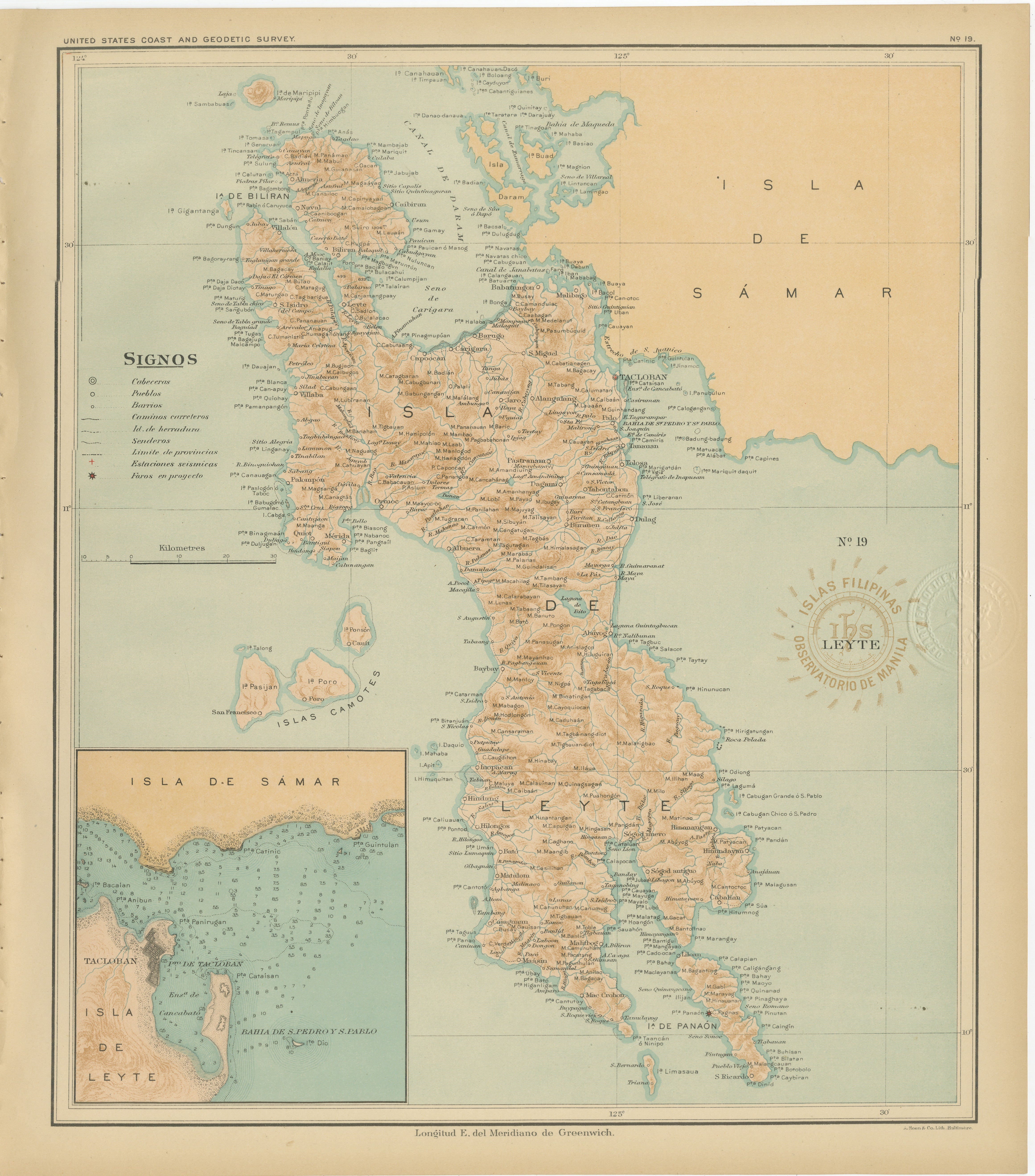
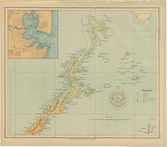
Map of the Island of Leyte – Observatorio de Manila, 1899
Located in Langweer, NL
Title: Map of the Island of Leyte – Observatorio de Manila, 1899
This beautifully detailed chromolithographed map titled “Islas Filipinas – Isla de Leyte” was created under the supe...
Category
Antique 1890s Philippine Maps
Materials
Paper

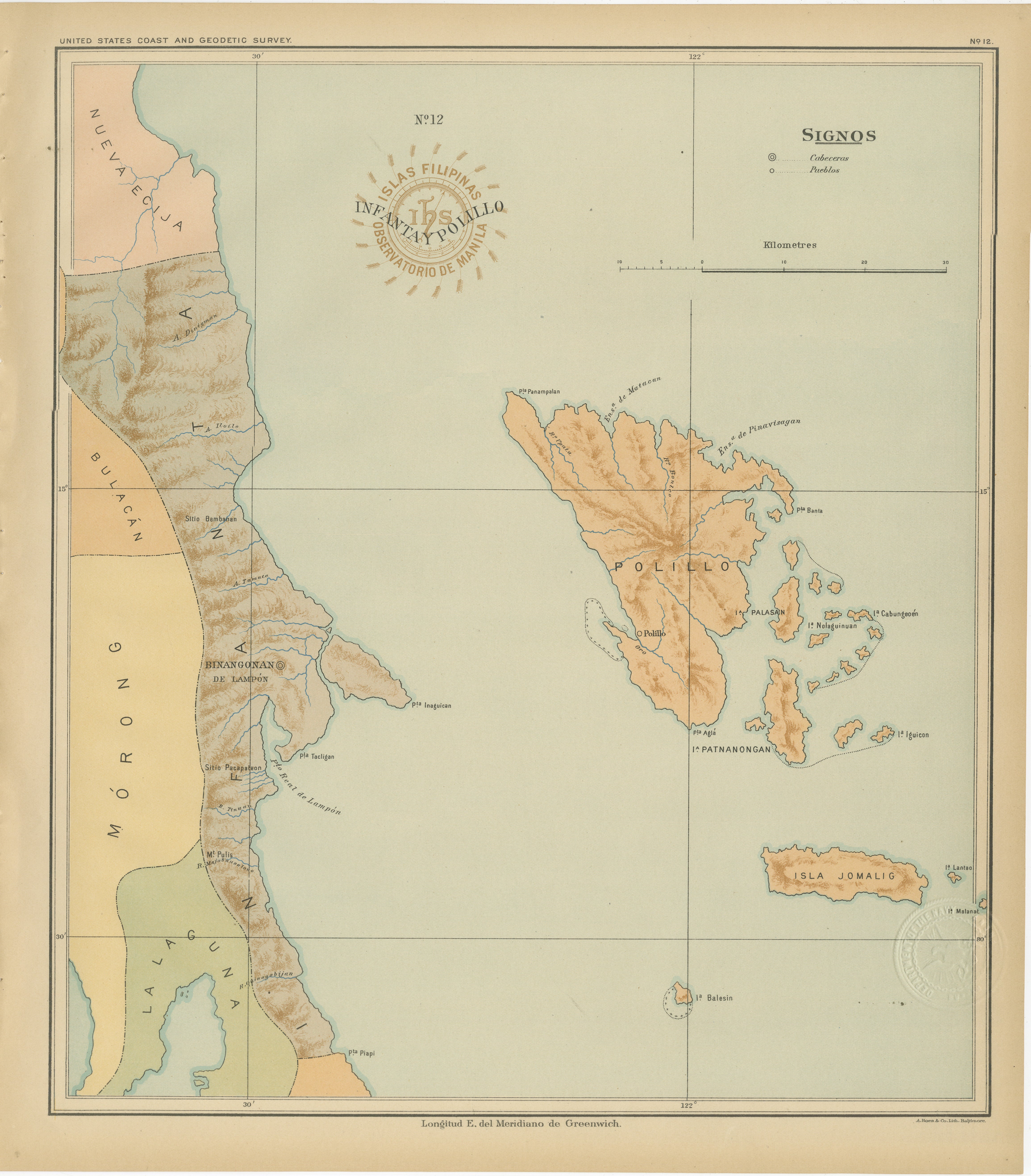
Map of Polillo Islands and Eastern Luzon Coast – Observatorio de Manila, 1899
Located in Langweer, NL
Map of Polillo Islands and Eastern Luzon Coast – Observatorio de Manila, 1899
This chromolithographed map titled “Islas Filipinas – Infanta y Polillo” was created in 1899 under the ...
Category
Antique 1890s Philippine Maps
Materials
Paper
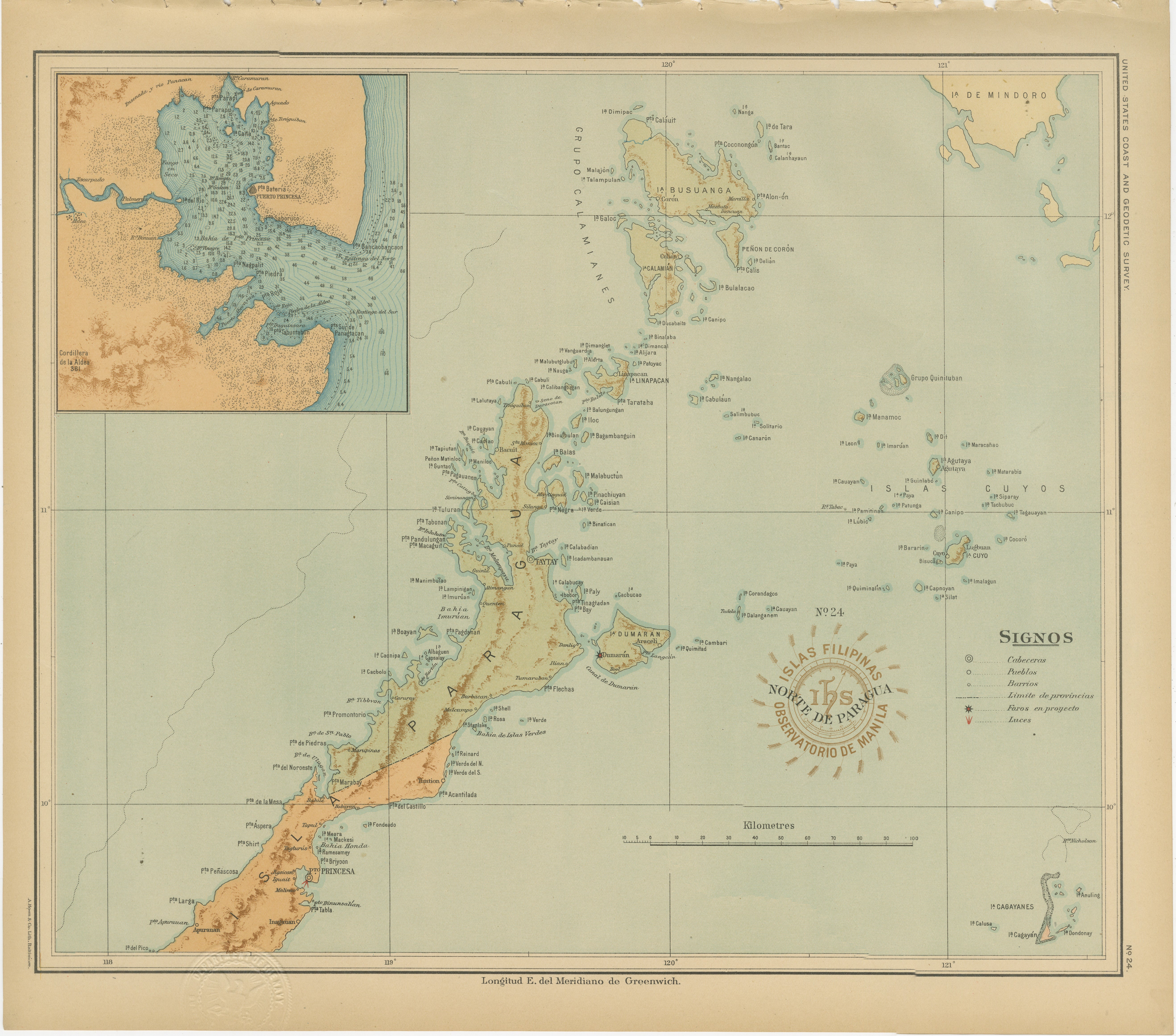
Map of the Northern Part of Palawan – Observatorio de Manila, 1899
Located in Langweer, NL
Title: Map of the Northern Part of Palawan – Observatorio de Manila, 1899
This finely detailed chromolithograph titled “Islas Filipinas – Norte de Paragua” depicts the northern regi...
Category
Antique 1890s Philippine Maps
Materials
Paper
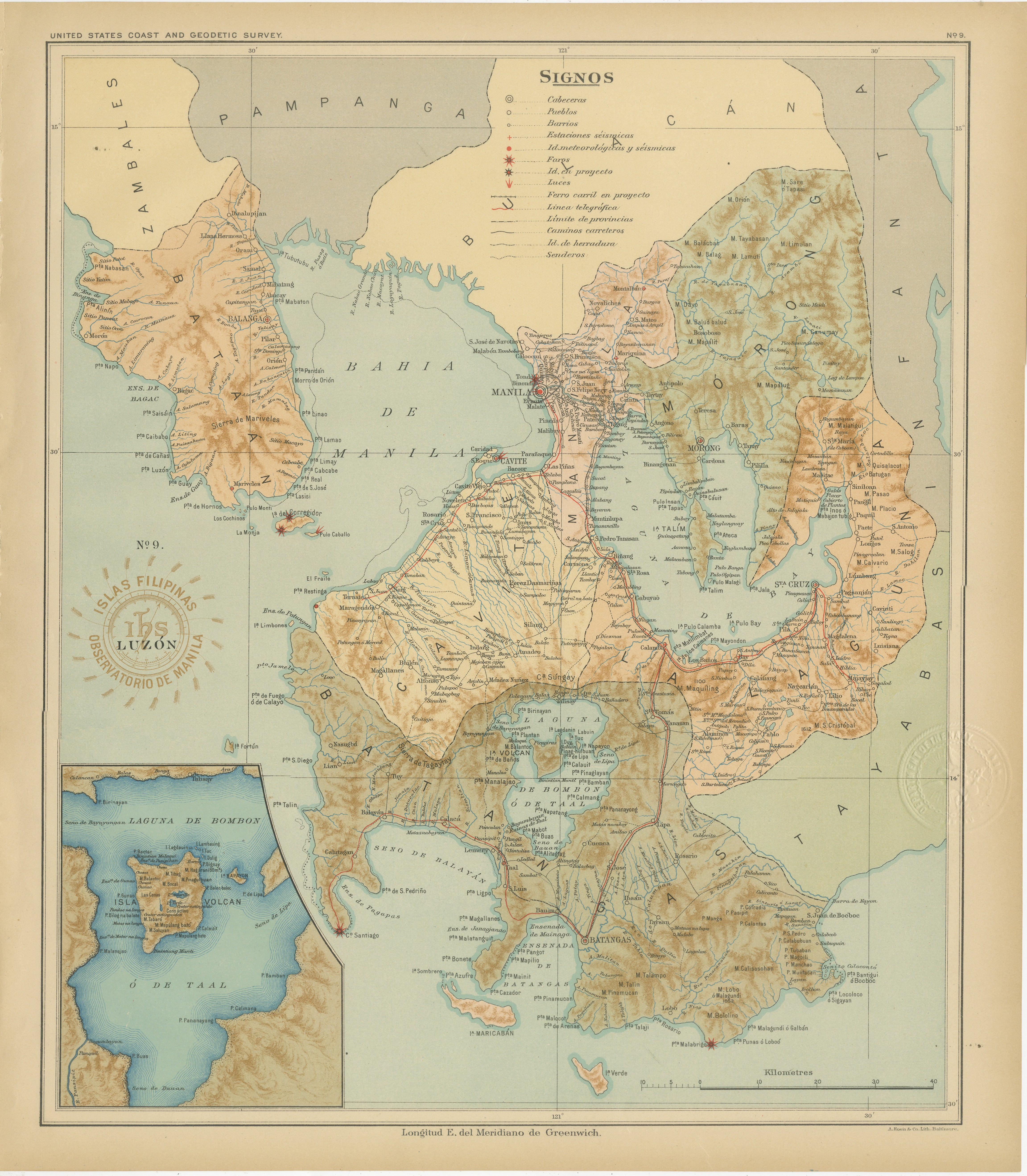
Map of Manila Bay and Southern Luzon – Observatorio de Manila, 1899
Located in Langweer, NL
Title: Map of Manila Bay and Southern Luzon – Observatorio de Manila, 1899
This finely detailed chromolithograph titled “Islas Filipinas – Luzón” was created in 1899 under the direc...
Category
Antique 1890s Philippine Maps
Materials
Paper
You May Also Like
Scarce U.S. Coast Survey Map Depicting Entrance to San Francisco Bay Dated 1856
Located in San Francisco, CA
A fine example of the 1856 U.S. Coast lithographic survey nautical chart of the entrance to San Francisco bay and the city. Published in 1856 by the Office of the Coast Survey the of...
Category
Antique Mid-19th Century American Maps
Materials
Paper

$780 Sale Price
47% Off
Original Antique Map of The Philippines. C.1900
Located in St Annes, Lancashire
Fabulous map of The Philippines
Original color.
Engraved and printed by the George F. Cram Company, Indianapolis.
Published, C.1900.
Unframed.
Free shipping.
Category
Antique 1890s American Maps
Materials
Paper

Original Antique Map of US Possessions In The Pacific Ocean, C.1900
Located in St Annes, Lancashire
Fabulous map of US possessions in the Pacific Ocean
Original color.
Engraved and printed by the George F. Cram Company, Indianapolis.
Published, C.1900.
Unframed.
Free shipping.
Category
Antique 1890s American Maps
Materials
Paper

Antique Maritime Chart of East Coast Virginia to Nova Scotia
Located in Norwell, MA
1920 nautical chart of the East Coast of the United States from Virginia to Maine, New Brunswick, and Nova Scotia. The chart shows Cape Cod, Long Island, the Connecticut coast, Jersey Shore, Maine, New Hampshire, etc. Very detailed, showing ports, lighthouses, shoals, depths, etc. The chart is by famous cartographer George W. Eldridge, compiled from surveys of the United States government, British Admiralty, George Eldridge, and others. First authorized by George Eldridge, published in 1916 by Wilfred O. White with a merchant's stamp of Charles Hutchinson...
Category
Vintage 1920s North American Maps
Materials
Paper

1898 Chart of Boston Bay
Located in Norwell, MA
Original 1898 chart showing Massachusetts Bay with the coast from Cape Ann to Cape Cod. This is a U.S. Navy Geodetic survey chart. All towns are noted along the coast. Framed with gl...
Category
Antique 1890s Nautical Objects
Materials
Paper

$1,495
19th Century Nautical Chart of Martinique
Located in Norwell, MA
Original map of Martinique from 1887 with chartered waters around the island. Prepared from a French survey, completed in 1825, showing town, ports, rivers and tributaries. Published...
Category
