Items Similar to Map of Sevilla Province, 1901: A Depiction of The Spanish Cultural Heartland

Want more images or videos?
Request additional images or videos from the seller
1 of 6
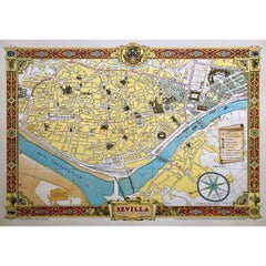
Map of Sevilla Province, 1901: A Depiction of The Spanish Cultural Heartland
$266.92
$381.3130% Off
£198.81
£284.0230% Off
€224
€32030% Off
CA$367.57
CA$525.1030% Off
A$400.09
A$571.5530% Off
CHF 211.99
CHF 302.8530% Off
MX$4,811.65
MX$6,873.7930% Off
NOK 2,695.42
NOK 3,850.6030% Off
SEK 2,470.05
SEK 3,528.6530% Off
DKK 1,706.73
DKK 2,438.1930% Off
About the Item
The print for sale here depicts a historical map of the province of Sevilla (Seville) from the year 1901. Sevilla is located in the southern part of Spain and is part of the autonomous community of Andalusia. It is rich in history and culture, and known for its architectural beauty, vibrant traditions, and lively festivals.
Some of the key highlights of Sevilla include:
1. **Seville Cathedral**: This is the largest Gothic cathedral in the world and is recognized as a UNESCO World Heritage Site. It was completed in the 16th century and is noted for its impressive size, magnificent architecture, and the Giralda, a bell tower that was originally a minaret.
2. **Alcázar of Seville**: Another UNESCO World Heritage site, the Alcázar is a royal palace that was originally a Moorish fort. It is an outstanding example of Mudéjar architecture and one of the oldest palaces still in use in Europe.
3. **Flamenco**: Sevilla is considered the birthplace of flamenco, a passionate and intense dance and musical style that has become synonymous with Spanish culture.
4. **Feria de Abril (April Fair)**: Sevilla's April Fair is a week-long celebration of music, dance, food, and culture. It is one of the most well-known and colorful local festivals in Spain.
5. **Plaza de España**: A landmark square located in the Parque de María Luisa, built for the Ibero-American Exposition of 1929. The plaza is a showcase of Renaissance and Moorish Revival styles in Spanish architecture.
6. **Cuisine**: The culinary scene in Sevilla is characterized by Andalusian cuisine with dishes like gazpacho, pescaíto frito (fried fish), and various tapas.
7. **Naval History**: The province of Sevilla has a rich naval history due to its location on the Guadalquivir River, which allowed it to be a major port for trade with the Americas during the Spanish Empire.
8. **Hot Climate**: Sevilla is known for its hot summer climate, which is one of the warmest in Europe, influencing the lifestyle and siesta culture of the region.
The province of Sevilla is a place where the past and present merge, creating a vibrant atmosphere that attracts tourists from all over the world. It is a region that has played a significant role in Spanish and global history, with a deep heritage that continues to be celebrated and preserved.
- Dimensions:Height: 14.77 in (37.5 cm)Width: 20.08 in (51 cm)Depth: 0 in (0.02 mm)
- Materials and Techniques:
- Period:1900-1909
- Date of Manufacture:1901
- Condition:Good condition. Central vertical folding lines as issued. Aged paper with typically warm, yellowish-brown hue, especially around the edges. Slightly brownish discoloring in the middle fold. Check the images carefully.
- Seller Location:Langweer, NL
- Reference Number:Seller: BG-13642-381stDibs: LU3054338032852
About the Seller
5.0
Recognized Seller
These prestigious sellers are industry leaders and represent the highest echelon for item quality and design.
Platinum Seller
Premium sellers with a 4.7+ rating and 24-hour response times
Established in 2009
1stDibs seller since 2017
2,824 sales on 1stDibs
Typical response time: 1 hour
- ShippingRetrieving quote...Shipping from: Langweer, Netherlands
- Return Policy
More From This Seller
View AllTopographical and Infrastructure Map of the Province of Valencia, 1901
Located in Langweer, NL
A historical map of the province of Valencia, dated 1901. The map includes intricate details such as topographical features, with mountain ranges and river systems prominently marked...
Category
Antique Early 1900s Spanish Maps
Materials
Paper

$495 Sale Price
20% Off
Free Shipping
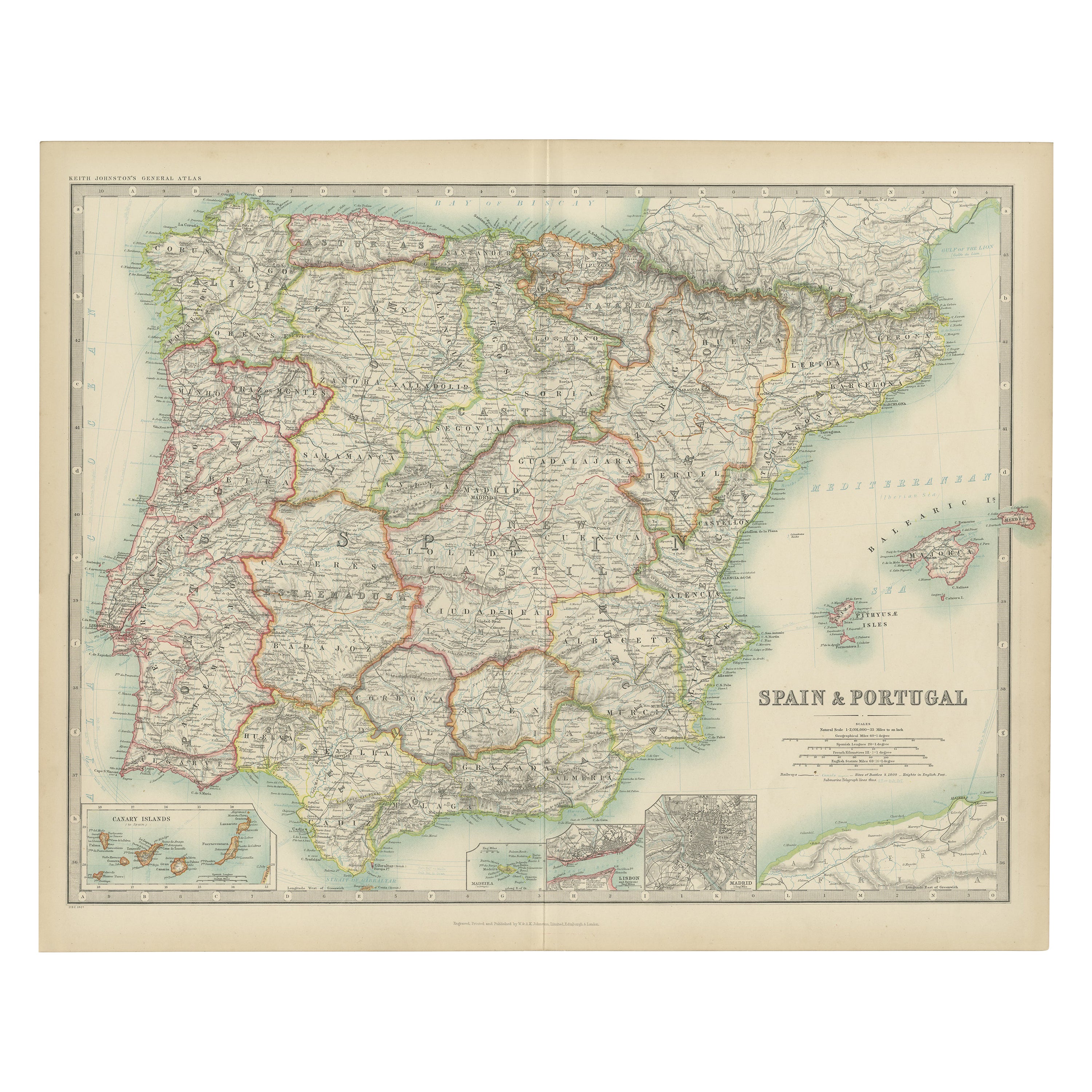
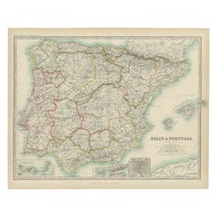
Antique Map of Spain and Portugal by Johnston,
1909
Located in Langweer, NL
Antique map titled 'Spain and Portugal'. Original antique map of Spain and Portugal. With inset maps of the Canary Islands, Madeira, Lisbon and Ma...
Category
Early 20th Century Maps
Materials
Paper
$238 Sale Price
20% Off
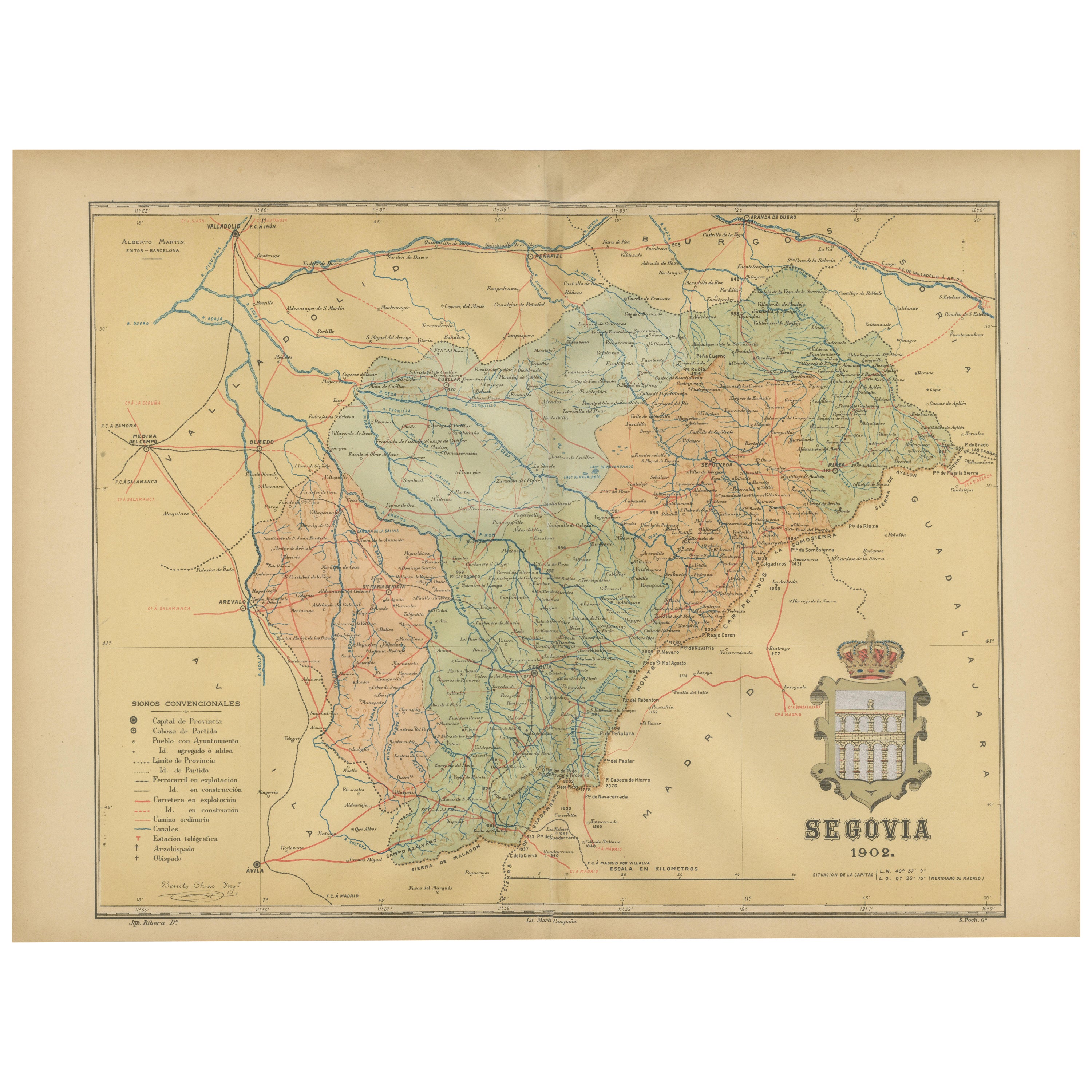
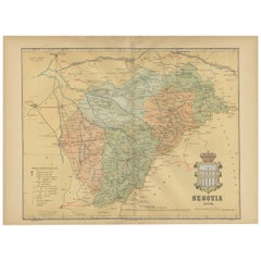
Topographical and Administrative Cartography of Segovia in Spain, 1902
Located in Langweer, NL
An original old map of the province of Segovia from the year 1902. Segovia is a historic area located in the central part of Spain, northwest of Madrid. Known for its rich history, a...
Category
Antique Early 1900s Maps
Materials
Paper
$276 Sale Price
20% Off
Free Shipping
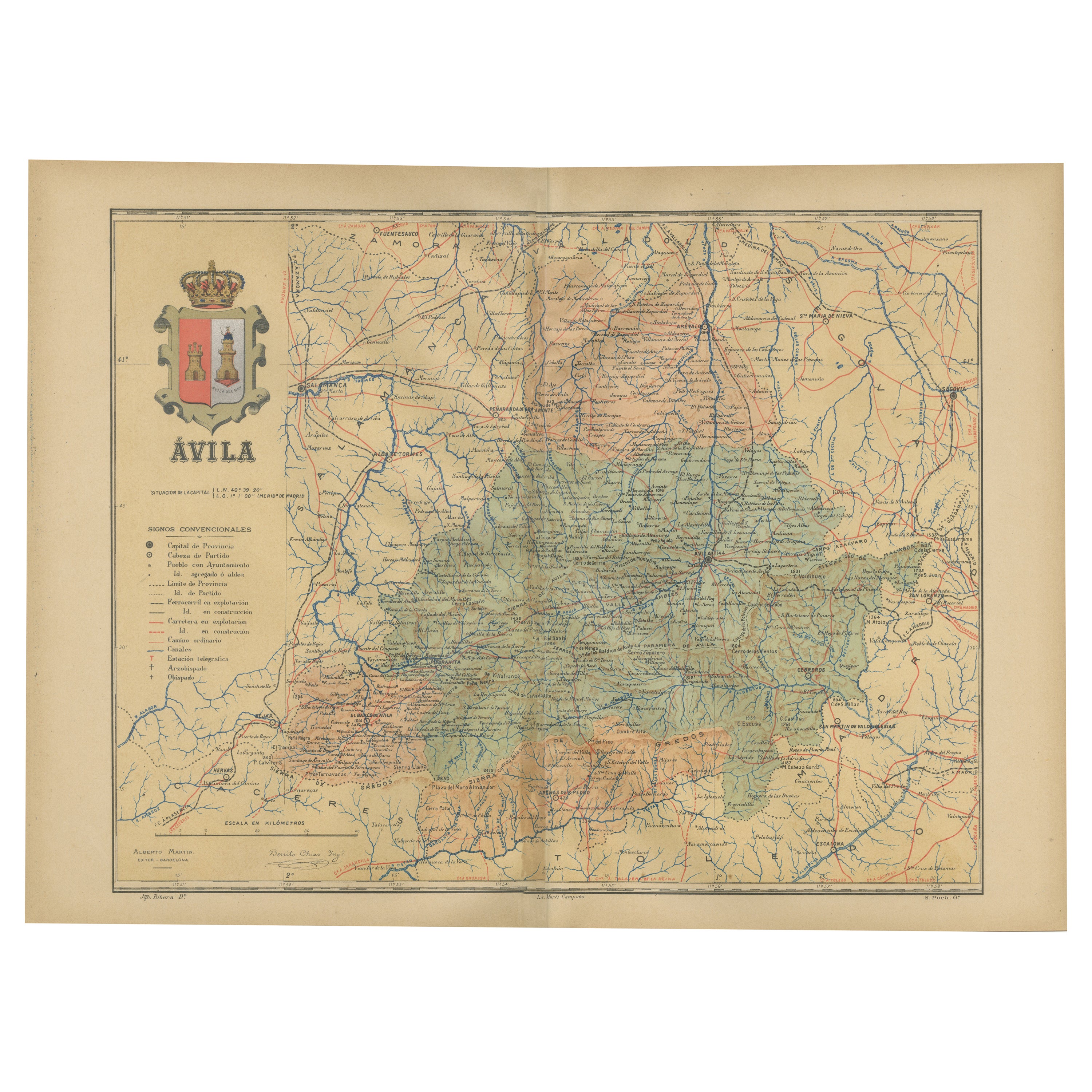
Ávila in a Historical Map of 1902: A Geographic and Administrative Overview
Located in Langweer, NL
The map is of the province of Ávila, one of the provinces of the autonomous community of Castile and León in Spain, and it is dated from 1902. The map illustrates several geographic ...
Category
Antique Early 1900s Maps
Materials
Paper

$276 Sale Price
20% Off
Free Shipping
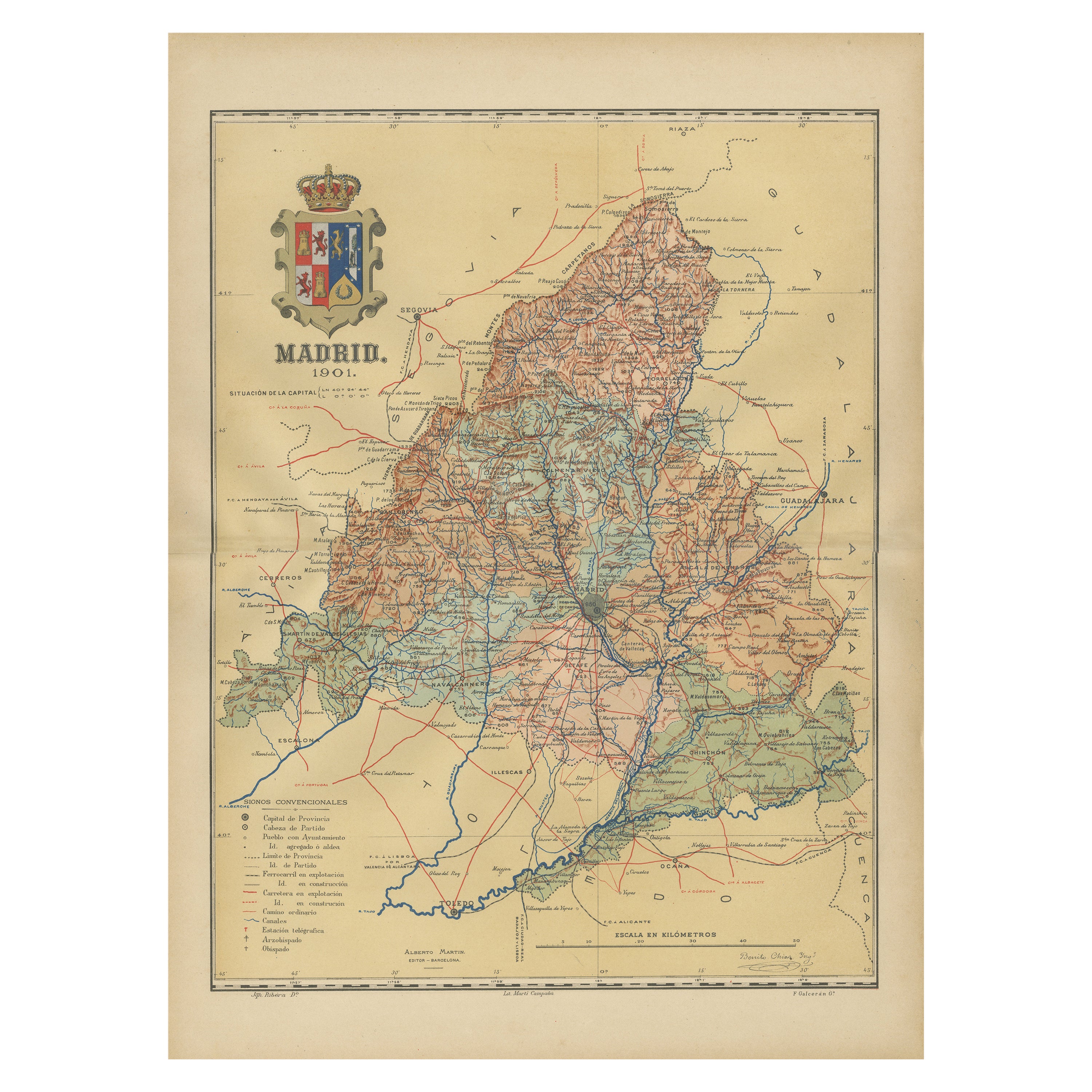
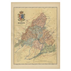
Madrid 1901: A Historical Map of Spain
s Capital Province
Located in Langweer, NL
The map is of the province of Madrid, the capital region of Spain, as it appeared in 1901. Here are the key features it displays:
The map shows the central part of Spain, with the Guadarrama mountain range prominently visible, marking the natural border to the north of Madrid.
Blue lines likely indicate rivers, including the Manzanares River, which flows through Madrid, and the Jarama River, a tributary to the Tagus.
Red lines depict the roads and railways, outlining the infrastructure that connects Madrid's various towns and cities within the province and beyond.
Symbols and labels mark the locations of cities, towns, and villages, with Madrid itself likely being the focal point. Dotted lines may represent the administrative divisions within the province. The map includes a legend (Signos Convencionales) that explains the symbols used for provincial capitals, roads, railways, and other geographic features.
The coat of arms of Madrid, featuring a bear and a strawberry tree (madroño), is prominently featured, symbolizing the city's and the province's historical coat of arms.
About the province of Madrid:
Madrid is not only the capital of Spain but also the heart of the Iberian Peninsula, both geographically and politically. The city is renowned for its rich repositories of European art, including the Prado Museum's works by Goya, Velázquez, and other Spanish masters. The province of Madrid is characterized by a blend of historical and modern elements, with a rich cultural life that includes theater, opera, and flamenco, as well as gastronomy that features a mix of traditional Spanish dishes and international cuisine...
Category
Antique Early 1900s Maps
Materials
Paper
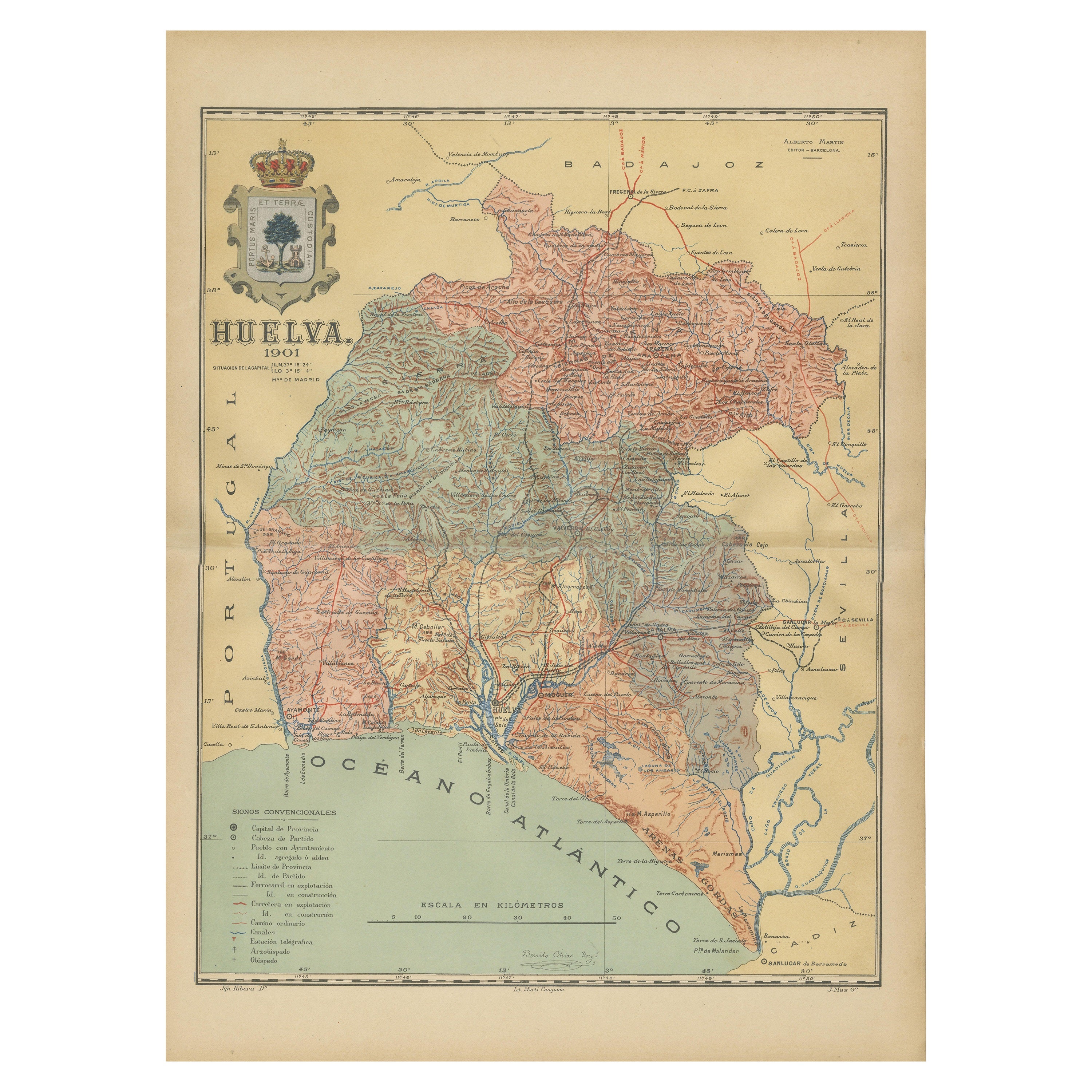
Huelva 1901: A Cartographic Presentation of Andalusia
s Atlantic Frontier
Located in Langweer, NL
The map displays the province of Huelva, located in the southwestern part of the autonomous community of Andalusia in Spain, as of the year 1901. It outlines various geographic and m...
Category
Antique Early 1900s Maps
Materials
Paper

$343 Sale Price
20% Off
Free Shipping
You May Also Like
Large Original Vintage Map of Spain, circa 1920
Located in St Annes, Lancashire
Great map of Spain
Original color.
Good condition
Published by Alexander Gross
Unframed.
Category
Vintage 1920s English Maps
Materials
Paper

Map of Spain and Portugal - Original Etching - Late 19th Century
Located in Roma, IT
This Map of Spain and Portugal is an etching realized by an anonymous artist.
The state of preservation of the artwork is good with some small diffused stains.
Sheet dimension: 28...
Category
Late 19th Century Modern Figurative Prints
Materials
Etching

1950 original map by Garcia Fuentes Manuel - Sevilla Perspectiva General
Located in PARIS, FR
The 1950 original map by Garcia Fuentes Manuel, titled "Sevilla Perspectiva General," offers a comprehensive and detailed overview of Seville as it stood...
Category
1950s Prints and Multiples
Materials
Linen, Paper, Lithograph
18th Century Hand Colored Map of Spain and Portugal by Visscher
By Nicolaes Visscher II
Located in Alamo, CA
This is an early 18th century map of Spain and Portugal, with attractive original hand-coloring, entitled "Hispaniae et Portugalliae Regna per Nicolaum Visscher cum Privilegio Ordinu...
Category
Antique Early 18th Century Dutch Maps
Materials
Paper

17th Century Lithograph Framed Map of Spain
Located in Atlanta, GA
In giltwood frame, dated 1652.
Category
Antique 18th Century and Earlier Spanish Baroque Prints
Materials
Ink, Paper

1751 Map of Spain Castilla Robert De Vaugondy 1st Edition, Ric.a001
Located in Norton, MA
Large Spain Castilla Robert De Vaugondy
1751 1st Edition
-Colored- Ric.a001
Coming from a family of cartographers, a descendant of the famous Nicolas Sanson and ordinary geographer of the king, Gilles Robert de Vaugondy makes himself known by his maps of the French provinces.
He published an Essay on the History of Geography (1755) from which he excluded the physical geography "too systematic". After a Small Atlas (1748), he draws a universal Atlas (1758), a portable Atlas (1762).
His Atlas of the revolutions of the globe remains unpublished. His warnings and prefaces, his book reviews reveal a Cartesian mind and solid knowledge.
Very early, he associates with his works his son Didier who publishes, since 1742, the methodical tables of Nicolas Sanson, two Globes, one terrestrial, the other celestial (1752).
He is credited with a map of Poland...
Category
Antique 18th Century Unknown Maps
Materials
Paper

More Ways To Browse
Moorish Revival
Antique Sultanabad Carpets
Used Beige Sofa
Antique Plate Germany
Hand Tufted Rugs
Rare China
Side Table Made In Denmark
Thonet Antique
Victorian Hall Tables
Vintage Computer
England Antique Plates
19th Century Round Dining Table
Antique Counters
Antique Thrones
Carved Chinese Tables
Italian Ceramic 1960s
Mid Century Modern Danish Teak Dining Tables
Rosenthal Century