Items Similar to Map of South America 1792 by Elwe – Hand-Colored Antique Dutch Engraving


Want more images or videos?
Request additional images or videos from the seller
1 of 10
Map of South America 1792 by Elwe – Hand-Colored Antique Dutch Engraving
$2,033.54
£1,510.02
€1,700
CA$2,793.98
A$3,038.76
CHF 1,610.43
MX$36,410.75
NOK 20,467.79
SEK 18,751.28
DKK 12,960.97
About the Item
Map of South America 1792 by Elwe – Hand-Colored Antique Dutch Engraving
This striking antique map of South America, titled "L'Amerique Meridionale," was published in 1792 by the Dutch cartographer Jan Barend Elwe in Amsterdam. It is a beautifully hand-colored copperplate engraving that exemplifies the high standard of Dutch mapmaking in the late 18th century. The map displays the continent divided into its principal regions and colonial territories of the time, including Brazil, Peru, Paraguay, Chile, Argentina, and Colombia. The geographical renderings are based on earlier French cartographic sources, particularly the work of Guillaume Delisle, yet Elwe's version is distinctive for its refined presentation and updated political boundaries.
Notably, the map includes two elaborate cartouches: one with the title, featuring a crowned globe and maritime motifs, and the other with a dedication and legend, adorned with palm trees, exotic animals, and tropical fruits—reflecting European fascination with the New World. The fine hand-coloring enhances the visual impact and helps distinguish the various colonial powers’ territories. The prime meridian used here is based on Paris, common among French-influenced maps of the time.
Jan Barend Elwe (active 1785–1795) was known for reissuing maps from prominent 17th- and 18th-century atlases, updating them for a new generation of map collectors and scholars. His 1792 edition of this map stands as one of the most decorative and desirable renditions of South America before the independence movements of the 19th century redrew the continent’s political borders.
This map is not only a geographical document but also a decorative and historical artifact, revealing how Europeans viewed and represented South America in the Age of Enlightenment.
Condition summary:
Very good condition with strong color and clear plate lines. Minor age toning and browning to the margins, no tears or repairs. A clean, well-preserved example of late 18th-century Dutch cartography.
Framing tip:
Frame with a neutral or olive mat and a gold or walnut wooden frame to complement the warm tones. UV-protective glass is recommended to preserve the hand-coloring and prevent further fading.
- Creator:J.B. Elwe (Artist)
- Dimensions:Height: 21.46 in (54.5 cm)Width: 25.6 in (65 cm)Depth: 0.02 in (0.5 mm)
- Materials and Techniques:Paper,Engraved
- Place of Origin:
- Period:
- Date of Manufacture:1792
- Condition:Wear consistent with age and use. Very good condition with strong color and clear plate lines. Minor age toning and browning to the margins, no tears or repairs. A clean, well-preserved example of late 18th-century Dutch cartography. Small tear at bottom of the middle-fold.
- Seller Location:Langweer, NL
- Reference Number:Seller: BG-021191stDibs: LU305438833113
About the Seller
5.0
Recognized Seller
These prestigious sellers are industry leaders and represent the highest echelon for item quality and design.
Platinum Seller
Premium sellers with a 4.7+ rating and 24-hour response times
Established in 2009
1stDibs seller since 2017
2,823 sales on 1stDibs
Typical response time: 1 hour
- ShippingRetrieving quote...Shipping from: Langweer, Netherlands
- Return Policy
More From This Seller
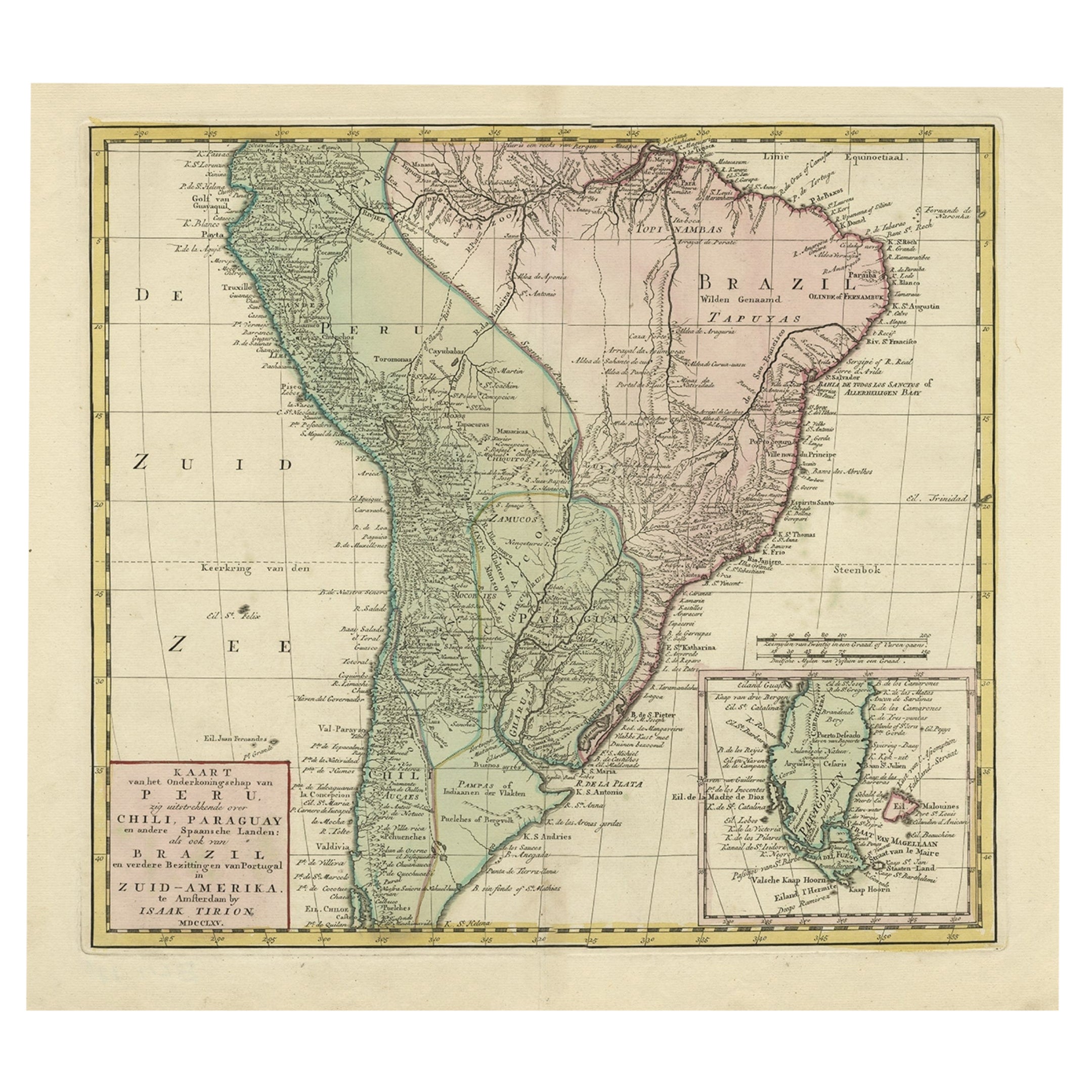
View AllAttractive Antique Hand-Coloured Map of South America, ca.1765
Located in Langweer, NL
Antique map titled 'Kaart van het Onderkoningschap van Peru zig uitstrekkende: over Chile, Paraguay en andere Spaansche Landen als ook van Brazil en verdere Bezittingen van Portugal ...
Category
Antique 1760s Maps
Materials
Paper
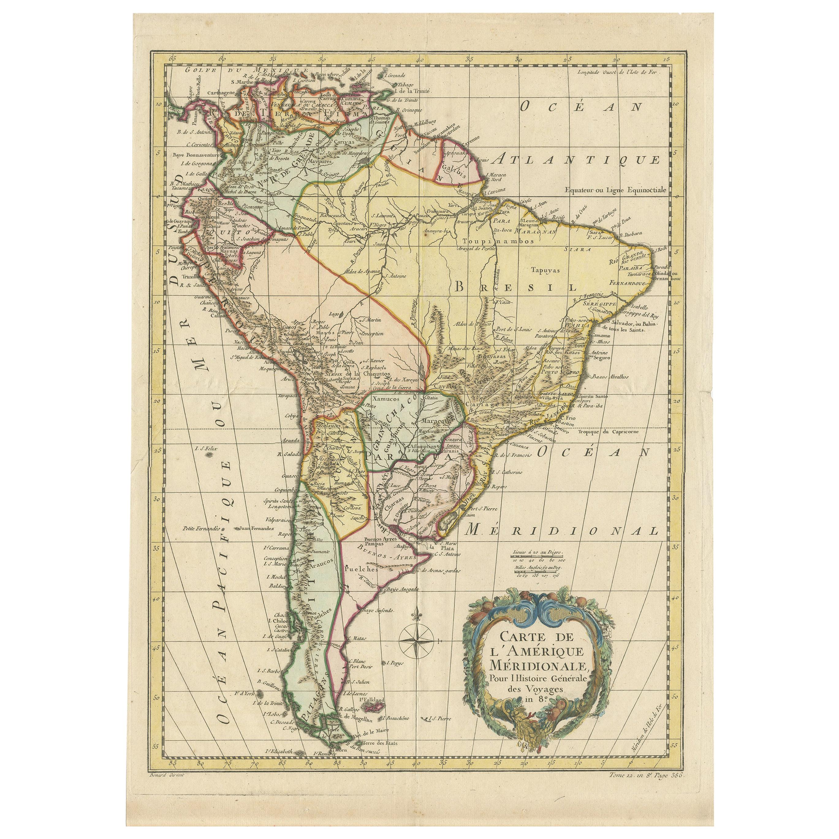
Antique Map of South America by De la Harpe
1780
Located in Langweer, NL
Antique map titled 'Carte de l'Amerique Méridionale'. Original antique map of South America. Note the 'Laguna de Xarayes' is illustrated as the source of the Paraguay river. The laguna is now known as Pantanal, world's largest tropical wetland area. This map orginates from 'Abrégé de l'histoire générale des Voyages' by J.F. de la Harpe.
Category
Antique Late 18th Century Maps
Materials
Paper

$478 Sale Price
20% Off
Antique Map of South America by Keizer
de Lat, 1788
Located in Langweer, NL
Antique map titled 'Kaartje van het Zuider-Deel van America'. Uncommon original antique map of South America. This map originates from 'Nieuwe Natuur- Geschied- en Handelkundige Zak-...
Category
Antique Late 18th Century Maps
Materials
Paper

$382 Sale Price
20% Off
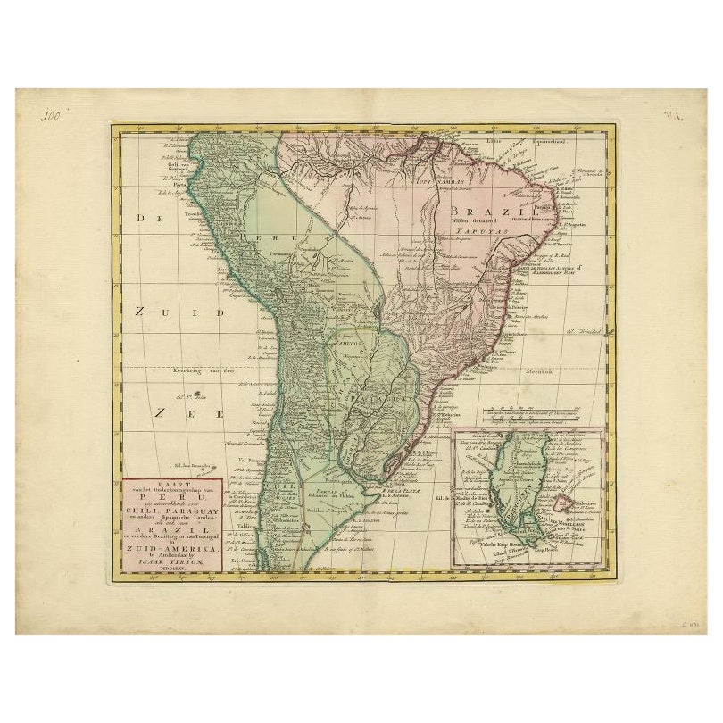
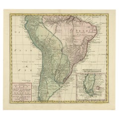
Antique Map of South America by Tirion
circa 1765
Located in Langweer, NL
Antique map titled 'Kaart van het Onderkoningschap van Peru, zig uitstrekkende over Chili, Paraguay en andere Spaansche Landen: als ook van Brazil en verdere Bezittingen van Portugal...
Category
Antique Mid-18th Century Maps
Materials
Paper

$478 Sale Price
20% Off
Antique Map of South America by Conder, c.1775
Located in Langweer, NL
Antique map titled 'South America agreeable to the most approved maps and charts'. Rare map of South America depicting Chili, La Plata, Paraguay, Brazil, Peru, the Amazon and surroun...
Category
Antique 18th Century Maps
Materials
Paper

$332 Sale Price
20% Off
Antique Map of South America by Tirion, c.1765
By Thomas Kitchin
Located in Langweer, NL
Antique map titled 'Kaart van het Onderkoningschap van Peru zig uitstrekkende: over Chile, Paraguay en andere Spaansche Landen als ook van Brazil en verdere Bezittingen van Portugal ...
Category
Antique 18th Century Maps
Materials
Paper

You May Also Like
North
South America: A 17th Century Hand-colored Map by Jansson
Goos
By Johannes Janssonius
Located in Alamo, CA
A 17th century hand-colored map of North & South America entitled "Americae Descriptio" by the cartographer Johannes Jansson, published in Jansson's Atlas Minor in Amsterdam in 1628....
Category
Antique 1620s Dutch Maps
Materials
Paper

$1,020 Sale Price
20% Off
South America: Hand-colored 18th Century Framed Map by Thomas Jefferys
By Thomas Jefferys
Located in Alamo, CA
This detailed hand-colored map of South America by Thomas Jefferys was published in London in 1750. The map shows countries, early colonial possessions, towns, rivers, mountains, and...
Category
Antique Mid-18th Century English Maps
Materials
Paper

$460 Sale Price
20% Off
North and South America: An 18th Century Hand-colored Map by Johann Homann
By Johann Baptist Homann
Located in Alamo, CA
This early 18th century hand-colored copperplate map of North and South America entitled "Totius Americae Septentrionalis Et Meridionalis Novissima Repraesentatio" was created by Johann Baptist Homann and published in Nuremberg, Germany, between 1710 and 1731. The map details cities, forts, mountains, forests and lakes, as well as districts. There is a decorative cartouche in the lower left which depicts a volcano, scenes representing the people in their native costumes, as well as animals and plants of the Americas. A village is seen in the background on the left. A second smaller decorative cartouche in the upper right includes text and a series of allegorical figures. A large portion if the north central and western portions of North America is left without detail, because the region was largely unexplored at the time this map was created. The map also shows "Terra Esonis Incognita", representing a mythical continuous land bridge from North America to Asia, a northwest passage. The map preceded the French and...
Category
Early 18th Century Old Masters Landscape Prints
Materials
Engraving

Original Antique Map of South America. C.1780
Located in St Annes, Lancashire
Great map of South America
Copper-plate engraving
Published C.1780
Two small worm holes to left side of map
Unframed.
Category
Antique Early 1800s English Georgian Maps
Materials
Paper

A Hand Colored 18th Century Framed Map of South America by Thomas Jefferys
Located in Alamo, CA
This detailed hand colored map of South America by Thomas Jefferys was published in London in 1750. The map shows countries, early colonial possessions, towns, rivers, mountains, and...
Category
Mid-18th Century Other Art Style Landscape Prints
Materials
Engraving

Early 19th Century Hand Coloured Map of North America by Aaron Arrowsmith
By Aaron Arrowsmith
Located in Hamilton, Ontario
Hand coloured map in French by English cartographer Aaron Arrowsmith (1750–1823) titled "Amerique Septentionale" (North America).
Map size: 9.5" x 8"
Mat size: 20.5" x 14.25".
Category
Antique Early 19th Century English Maps
Materials
Paper

$795 Sale Price
36% Off
More Ways To Browse
Dutch Engravings
B Holland
18th Century American Antiques
Antique Russian Rugs
For Kids
Sterling Silver Flatware Set Service For 12
Tufted Bar
Pair Of French Antique Armchairs
1970s Brass Glass Coffee Table
Charles Rennie Mackintosh For Cassina
Glass Salt
Italian Modern Silver Vases
Vintage Resin Tables
Antique English Country Furniture
Blue Kilim Vintage
Contemporary Side Tables And Stools
Decorative Wall Plate
Mid Century Modern Corner Chair