Items Similar to Map of United States Central Sheet 1903 – Railroads, States, and Topography


Want more images or videos?
Request additional images or videos from the seller
1 of 10
Map of United States Central Sheet 1903 – Railroads, States, and Topography
$326.67
$408.3420% Off
£241.98
£302.4720% Off
€272
€34020% Off
CA$446.97
CA$558.7120% Off
A$486.34
A$607.9220% Off
CHF 257.51
CHF 321.8920% Off
MX$5,850.95
MX$7,313.6920% Off
NOK 3,269.79
NOK 4,087.2320% Off
SEK 2,991.63
SEK 3,739.5320% Off
DKK 2,072.86
DKK 2,591.0820% Off
About the Item
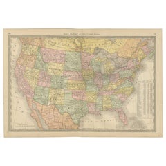
Map of United States Central Sheet 1903 – Railroads, States, and Topography
This is a finely engraved and beautifully colored map titled "United States of North America (Central Sheet)," created by Keith Johnston and printed by W.
A.K. Johnston, Ltd., in London and Edinburgh. This antique map, dating to the early 20th century, showcases the heartland of the United States in meticulous detail, spanning from the Gulf of Mexico up through the Great Lakes region.
The map covers the states of Texas, Oklahoma, Kansas, Nebraska, the Dakotas, Minnesota, Wisconsin, Iowa, Missouri, and Illinois, with surrounding areas of Colorado, Wyoming, Michigan, Arkansas, and Louisiana. Key features include railroad networks that highlight the rapid industrial expansion of the time, major rivers and mountain ranges, county boundaries, and settlements. The shading and contouring beautifully depict the topography, while delicate hand-coloring demarcates state boundaries with elegant clarity.
Inset with a detailed scale and a small table of mileages, the map is a testament to both the artistry and precision of historical cartography. The typography is crisp and classic, conveying both geographical and cultural importance for historians, map enthusiasts, and collectors.
Condition is very good for its age, with only minimal signs of wear and slight toning around the edges, consistent with gentle handling over the decades. The colors remain vibrant, enhancing the visual appeal of this historical piece.
For framing, consider a traditional dark wood frame to complement the antique style, or a simple black frame to modernize the look while preserving the map’s elegance. A neutral cream or off-white mat would highlight the engraved details and colors. This map would make a wonderful display for a home library, study, or any setting that celebrates American history.
- Dimensions:Height: 18.51 in (47 cm)Width: 14.49 in (36.8 cm)Depth: 0.01 in (0.2 mm)
- Materials and Techniques:
- Place of Origin:
- Period:
- Date of Manufacture:1903
- Condition:Condition is very good for its age, with only minimal signs of wear and slight toning around the edges, consistent with gentle handling over the decades. The colors remain vibrant, enhancing the visual appeal of this historical piece.
- Seller Location:Langweer, NL
- Reference Number:Seller: BG-13577-471stDibs: LU3054345291852
About the Seller
5.0
Recognized Seller
These prestigious sellers are industry leaders and represent the highest echelon for item quality and design.
Platinum Seller
Premium sellers with a 4.7+ rating and 24-hour response times
Established in 2009
1stDibs seller since 2017
2,816 sales on 1stDibs
Typical response time: 1 hour
- ShippingRetrieving quote...Shipping from: Langweer, Netherlands
- Return Policy
More From This Seller
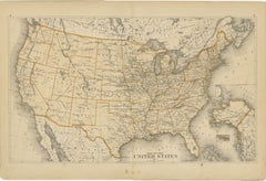
View AllMap of Western United States 1903 – Railroads, State Borders, and Terrain
Located in Langweer, NL
Map of Western United States 1903 – Railroads, State Borders, and Terrain
This beautifully engraved map titled "United States of North America (Western Sheet)" was created by Keith ...
Category
Early 20th Century Maps
Materials
Paper

United States Antique Map c.1888 – Railroads, Territories
State Stats
Located in Langweer, NL
Antique Map of the United States – Rand McNally, circa 1888
This antique map of the United States was published by Rand, McNally & Co. around 1888. It presents a colorful overview o...
Category
Antique Late 19th Century American Maps
Materials
Paper
Antique Railroad Map of the United States by Rand, McNally
Co, 1900
Located in Langweer, NL
Antique map titled 'Rand, McNally & Co's New Official Railroad map of the United States with portions of The Dominion of Canada, The Republic of Mexico and the West Indies'. Large railroad map of the United States, sectionalised and laid on linen. Map shows state boundaries for the United States, Mexico, the West Indies, and lower portion of Canada; major cities and towns, military posts, Native American reservations, and railroads; Oklahoma and "Indian Territory." Inset: "Map of Alaska...
Category
20th Century Maps
Materials
Linen, Paper

$2,251 Sale Price
25% Off
Free Shipping
1874 Map of Western United States – Detailed Atlas by Keith Johnston
Located in Langweer, NL
1874 Map of Western United States by Keith Johnston – Detailed Atlas
This is an original antique map titled “United States of North America (Western States)” by Alexander Keith John...
Category
Antique 1870s Scottish Maps
Materials
Paper

Antique Map of the United States of North America, c.1882
Located in Langweer, NL
Antique map titled 'United States of North America'. Old map of the United States of North America. This map originates from 'The Royal Atlas of Modern Geography, Exhibiting, in a Se...
Category
Antique 1880s Maps
Materials
Paper

1874 Map of the United States with Territorial Boundaries
Located in Langweer, NL
Title: 1874 Map of the United States with Territorial Boundaries
Description: This is an 1874 map titled "Map of the United States," showcasing the country during a period of rapid ...
Category
Antique 1870s Maps
Materials
Paper
$249 Sale Price
20% Off
You May Also Like
Original Antique Map of The United States of America by Dower, circa 1835
Located in St Annes, Lancashire
Nice map of the USA
Drawn and engraved by J.Dower
Published by Orr & Smith. C.1835
Unframed.
Free shipping
Category
Antique 1830s English Maps
Materials
Paper

Large Original Antique Map of the United States of America. 1891
By Rand McNally
Co.
Located in St Annes, Lancashire
Fabulous map of The United States
Original color
By Rand, McNally & Co.
Dated 1891
Unframed
Free shipping.
Category
Antique 1890s American Maps
Materials
Paper

North America. Century Atlas antique vintage map
Located in Melbourne, Victoria
'The Century Atlas. North America'
Original antique map, 1903.
Central fold as issued. Map name and number printed on the reverse corners.
Sheet 40cm by 29.5cm.
Category
Early 20th Century Victorian More Prints
Materials
Lithograph

Original Antique Map of United States, Grattan and Gilbert, 1843
Located in St Annes, Lancashire
Great map of United States
Drawn and engraved by Archer
Published by Grattan and Gilbert. 1843
Original colour
Unframed.
Category
Antique 1840s English Maps
Materials
Paper

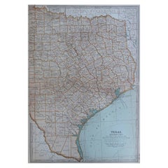
Original Antique Map of the American State of Texas ( Eastern Part ), 1903
Located in St Annes, Lancashire
Antique map of Texas ( Eastern part )
Published By A & C Black. 1903
Original colour
Good condition
Unframed.
Free shipping
Category
Antique Early 1900s English Maps
Materials
Paper
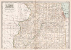
Illinois, Northern Part. USA. Century Atlas state antique vintage map
Located in Melbourne, Victoria
'The Century Atlas. Illinois, Northern Part'
Original antique map, 1903.
Central fold as issued. Map name and number printed on the reverse corners.
Sheet 29.5cm by 40cm.
Category
Early 20th Century Victorian More Prints
Materials
Lithograph
More Ways To Browse
Cream Soup
Early English Silver
Paisley Rugs and Carpets
Black And Chrome Lounge Chair
Vintage 1930 Dining Room Set
Antique Brass And Copper
Antique Cow
Antique Harvest
Antique Victorian Dining Tables
Environment Furniture
Italian Plastic Chairs
Made In Belgium
Black Crystal Glasses
French Mid Century Modern Rug
China Silk Rug
Chrome Glass Coffee Tables
Antique Italian Chairs
Antique Walnut Bar