Items Similar to Mexico Antique Railroad Map c.1888 – Cities, States
Land of the Aztecs


Video Loading
Want more images or videos?
Request additional images or videos from the seller
1 of 14
Mexico Antique Railroad Map c.1888 – Cities, States
Land of the Aztecs
$550.19
£408.55
€460
CA$755.88
A$821.79
CHF 435.71
MX$9,851.16
NOK 5,537.69
SEK 5,073.28
DKK 3,506.68
About the Item
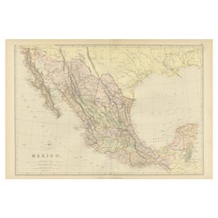
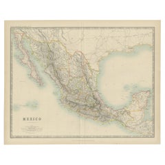
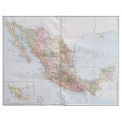
Antique Map of Mexico – Rand McNally, circa 1888
This antique map titled *“Rand, McNally
Co.’s Mexico”* was published around 1888 and depicts Mexico in the late 19th century, a period of modernization and national consolidation under the Porfirio Díaz regime. Covering the entire country from the U.S. border in the north to the Yucatán Peninsula in the south, the map includes Baja California, the Gulf of Mexico, and adjacent regions of Texas, New Mexico, and Central America.
The map is rich in geographical and political detail, showing state boundaries, cities, towns, rivers, and mountain ranges. A particularly important feature is the extensive railroad network, printed in red and blue, which highlights the rapid development of Mexico’s transportation infrastructure during the late 19th century. Mexico City, Guadalajara, Monterrey, Veracruz, Mérida, and many smaller towns are precisely engraved, along with ports on both the Pacific and Gulf coasts.
The Gulf of Mexico and Pacific coastlines are carefully delineated with shading to indicate relief and coastal waters. Insets are not present, as the focus remains on the full national extent. This map offers both an attractive visual presentation and a historical record of Mexico during a transformative era, just prior to the political upheavals of the Mexican Revolution in the early 20th century.
Condition report:
Very good condition with mild toning and a faint vertical center fold as issued. Marginal handling wear present but not affecting the printed image. Plate mark visible.
Framing tips:
A dark oak or walnut frame with a neutral cream or ivory mat provides an elegant display for this map. For a stronger visual statement, a double mat in ivory with a thin red inner line can echo the railroad markings, enhancing its historical character.
Technique: Lithograph with original color
Maker: Rand, McNally
Co., Chicago, circa 1888
- Dimensions:Height: 14.18 in (36 cm)Width: 20.67 in (52.5 cm)Depth: 0.01 in (0.2 mm)
- Materials and Techniques:Paper,Engraved
- Place of Origin:
- Period:
- Date of Manufacture:1888
- Condition:Very good condition with mild toning and a faint vertical center fold as issued. Marginal handling wear present but not affecting the printed image. Plate mark visible.
- Seller Location:Langweer, NL
- Reference Number:Seller: BG-12794-31stDibs: LU3054346476062
About the Seller
5.0
Recognized Seller
These prestigious sellers are industry leaders and represent the highest echelon for item quality and design.
Platinum Seller
Premium sellers with a 4.7+ rating and 24-hour response times
Established in 2009
1stDibs seller since 2017
2,821 sales on 1stDibs
Typical response time: 1 hour
- ShippingRetrieving quote...Shipping from: Langweer, Netherlands
- Return Policy
More From This Seller
View All1882 Antique Map of Mexico Highlighting Geographical and Political Boundaries
Located in Langweer, NL
This 1882 map of Mexico, published by Blackie and Son as part of the 'Comprehensive Atlas and Geography of the World,' provides a highly detailed representation of the country's geog...
Category
Antique 1880s Maps
Materials
Paper
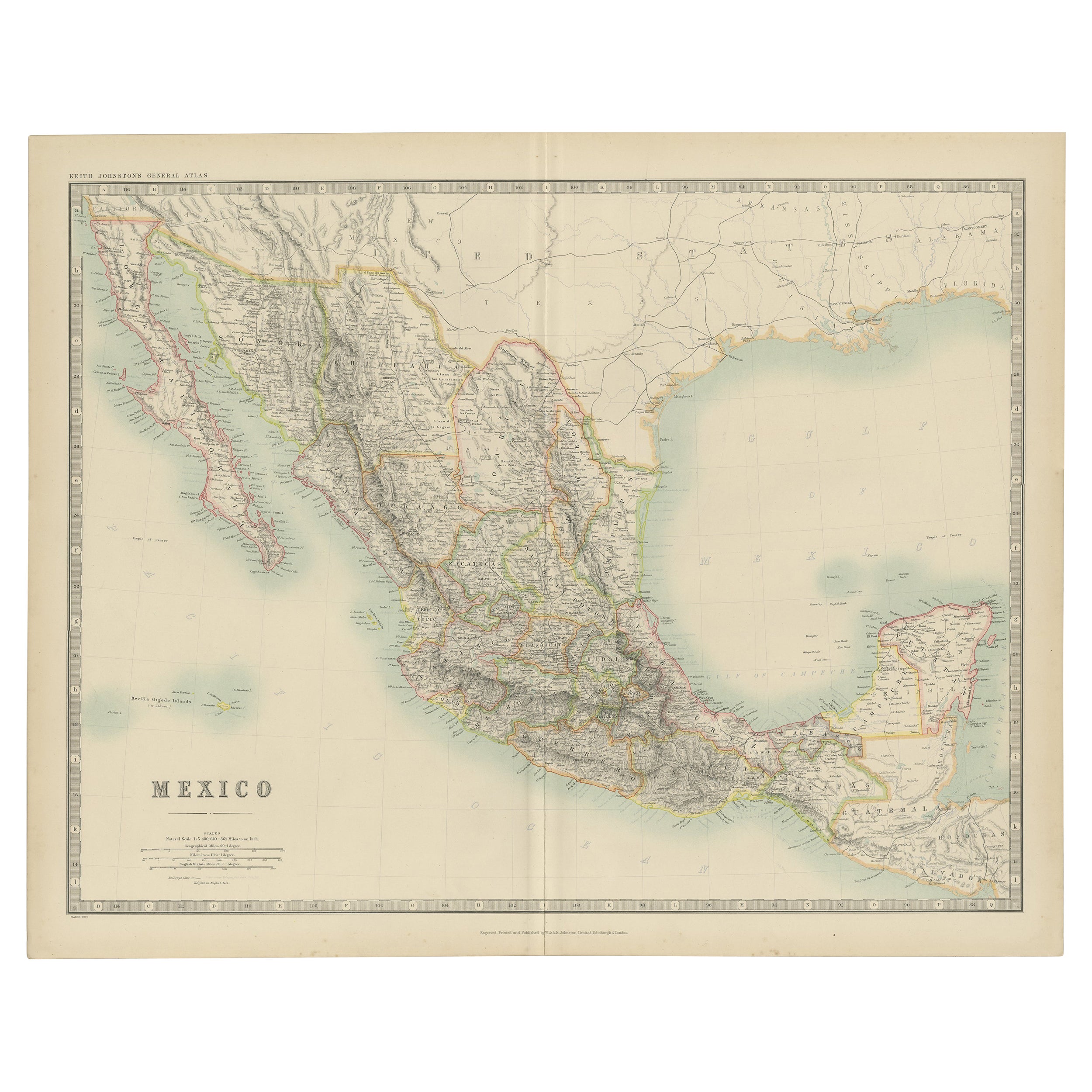
Antique Map of Mexico by Johnston,
1909
Located in Langweer, NL
Antique map titled 'Mexico'. Original antique map of Mexico. This map originates from the ‘Royal Atlas of Modern Geography’. Published by W. & A....
Category
Early 20th Century Maps
Materials
Paper
$239 Sale Price
20% Off
Antique Map of Mexico and Central America by Johnson
1872
Located in Langweer, NL
Antique map titled 'Johnson's Mexico (..)'. Two maps one one sheet showing Mexico and Central America, with inset maps of Tehuantepec and Panama. This map originates from 'Johnson's ...
Category
Antique Late 19th Century Maps
Materials
Paper

$287 Sale Price
20% Off
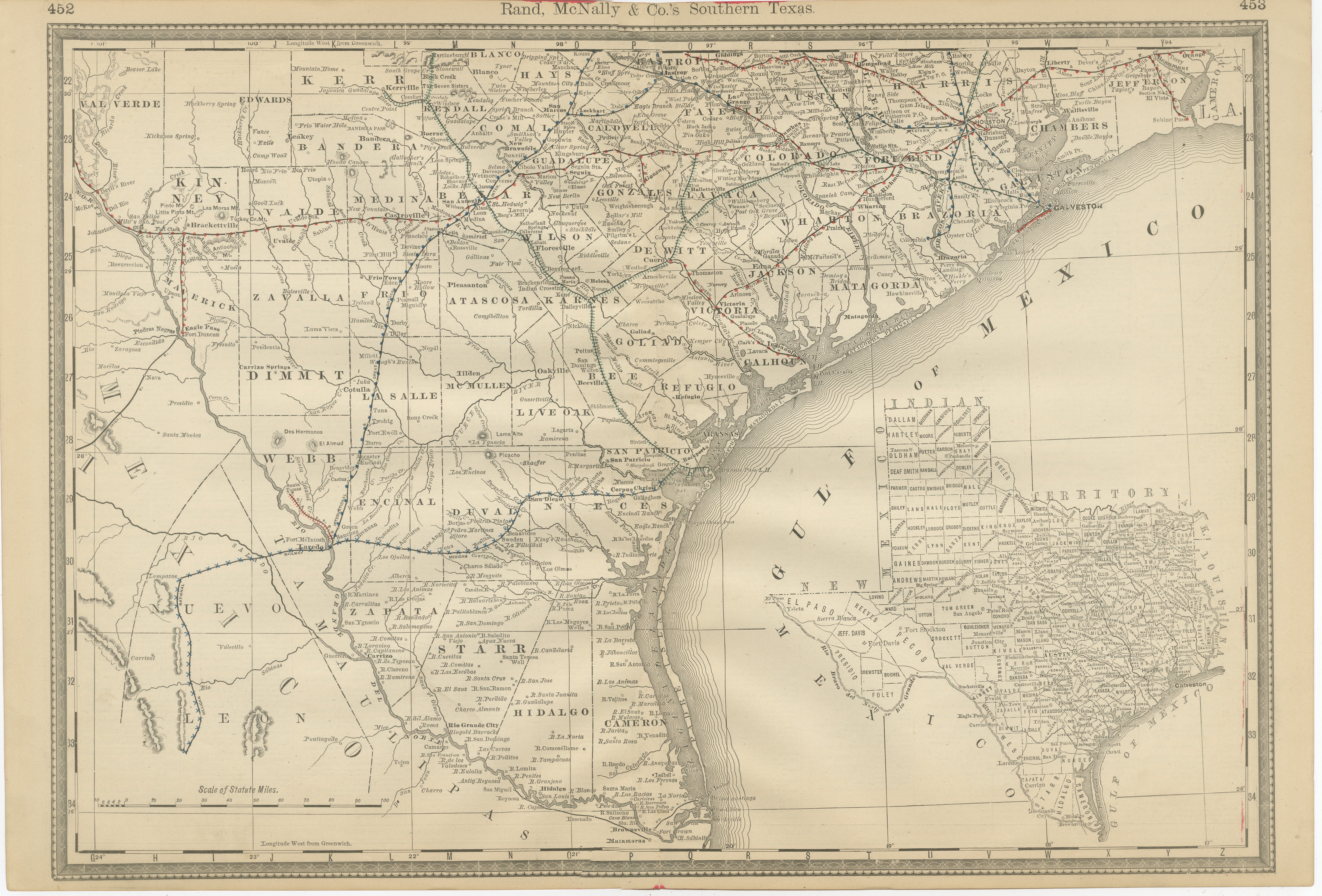
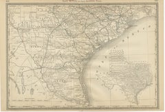
Antique Map 1888 – Southern Texas Railroads, Counties
Settlements
Located in Langweer, NL
Southern Texas Map 1888 – Rand McNally Antique Lithograph
This antique 1888 map of Southern Texas, published by Rand, McNally & Co., depicts the Gulf Coast and borderlands with Mexi...
Category
Antique Late 19th Century American Maps
Materials
Paper
United States, Mexico
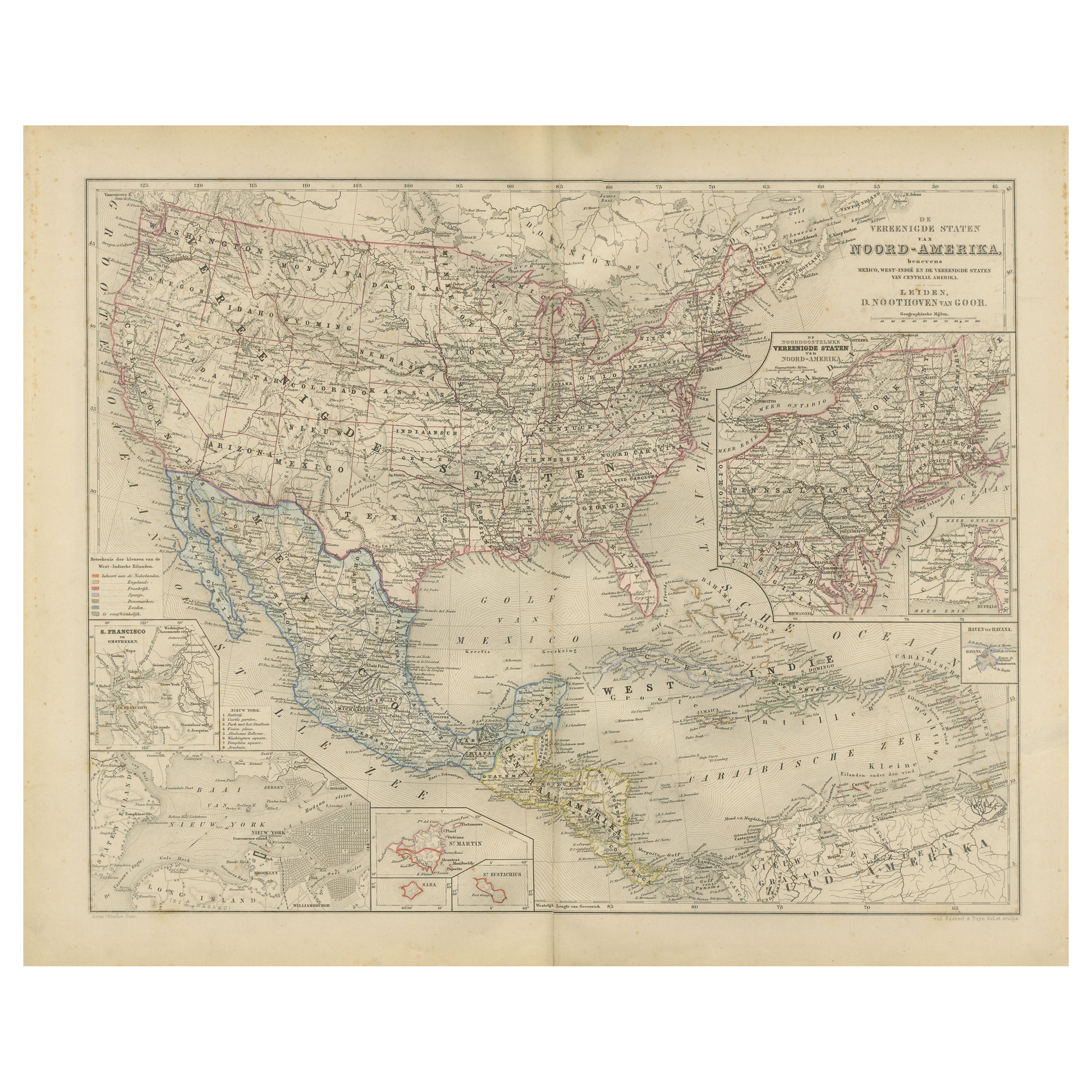
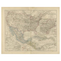
West Indies Map – Nieuwe Hand-Atlas, 1876
Located in Langweer, NL
United States, Mexico & West Indies Map – Nieuwe Hand-Atlas, 1876
This richly detailed 1876 map, titled “De Vereenigde Staten van Noord-Amerika, Mexico, West-Indië en de Vereenigde ...
Category
Antique 1870s Dutch Maps
Materials
Paper
Antique Map of the United States with inset map of the region of Mexico City
Located in Langweer, NL
Antique map titled 'Verein-Staaten von Nord-America, Mexico, Yucatan u.a.'. Very detailed map of the United States of America showing the Caribbean. With an inset map of the surround...
Category
Antique Mid-19th Century Maps
Materials
Paper

$822 Sale Price
20% Off
You May Also Like
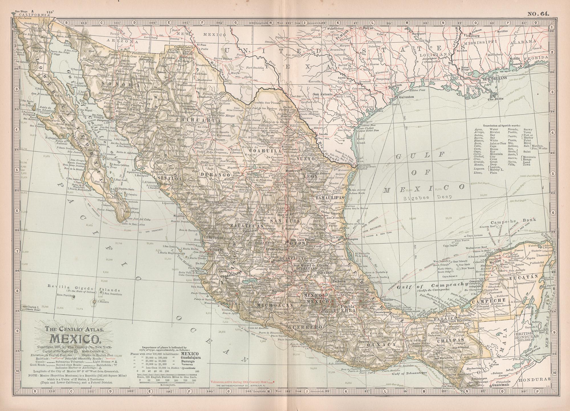
Mexico. Century Atlas antique vintage map
Located in Melbourne, Victoria
'The Century Atlas. Mexico.'
Original antique map, 1903.
Central fold as issued. Map name and number printed on the reverse corners.
Sheet 29.5cm by 40cm.
Category
Early 20th Century Victorian More Prints
Materials
Lithograph

1847 Antique Map of Mexico, Texas and California by Samuel Augustus Mitchell
By Samuel Augustus Mitchell 1
Located in Colorado Springs, CO
Presented is the second edition of Samuel Augustus Mitchell's Map of Mexico, Including Yucatan & Upper California, an important map showing the progress of the Mexican-American War. ...
Category
Antique 1840s American Maps
Materials
Paper

Large Original Vintage Map of Mexico, circa 1920
Located in St Annes, Lancashire
Great map of Mexico
Original color.
Good condition
Published by Alexander Gross
Unframed.
Category
Vintage 1920s English Edwardian Maps
Materials
Paper
Central America. Century Atlas antique vintage map
Located in Melbourne, Victoria
'The Century Atlas. Central America.'
Original antique map, 1903.
Inset maps of 'The Country around Lake Nicaragua'.
Central fold as issued. Map name and number printed on the reve...
Category
Early 20th Century Victorian More Prints
Materials
Lithograph

Original Antique Map of Central America / Florida, Arrowsmith, 1820
Located in St Annes, Lancashire
Great map of Central America.
Drawn under the direction of Arrowsmith.
Copper-plate engraving.
Published by Longman, Hurst, Rees, Orme and Brown, 1820
Unframed.
Category
Antique 1820s English Maps
Materials
Paper

South America, North-West Part. Century Atlas antique vintage map
Located in Melbourne, Victoria
'The Century Atlas. South America, North-West Part'
Original antique map, 1903.
Central fold as issued. Map name and number printed on the reverse corners.
Sheet 40cm by 29.5cm.
Category
Early 20th Century Victorian More Prints
Materials
Lithograph
