Items Similar to Mission of the Moxos, Peru – Antique French Jesuit Map by Portier, c.1790


Want more images or videos?
Request additional images or videos from the seller
1 of 10
Mission of the Moxos, Peru – Antique French Jesuit Map by Portier, c.1790
$395.07
£295.44
€330
CA$544.38
A$593.91
CHF 314.47
MX$7,116.71
NOK 4,004.96
SEK 3,662.24
DKK 2,513.34
About the Item
Mission of the Moxos, Peru – Antique French Jesuit Map by Portier, c.1790
This antique French map, engraved by Portier around 1790, depicts the “Mission des Moxes” in the Viceroyalty of Peru, showing the extensive network of Jesuit mission settlements in the lowland region of present-day Bolivia. The map’s full title, translated, reads: “Mission of the Moxos established by the Fathers of the Society of Jesus in Peru.”
The engraving provides a detailed geographic representation of the region’s rivers, mountain ranges, and indigenous territories, with mission towns clearly labeled, including San Pedro, San Miguel, San Pablo, Santa Ana, San Ignacio, San José, San Borja, and many others. The Moxos (or Mojos) region was one of the most important centers of Jesuit missionary activity in South America during the 17th and 18th centuries, where the Fathers worked to convert, educate, and organize local indigenous communities into self-sustaining settlements.
The map is richly detailed, with careful hachuring to indicate mountainous terrain, and decorative flourishes such as a title cartouche and neatline coordinates. The placement of rivers such as the Mamoré and Beni, along with tributaries and smaller waterways, reflects the central role of river travel and trade in the region.
By the time this map was published, the Jesuits had been expelled from Spanish America (1767), but their mission settlements continued to function for some time under other administration. As such, this engraving serves as both a geographic record and a historical testament to the Jesuit presence in South America.
Condition report: Good condition with a strong plate mark and clear impression. Light toning and faint foxing, mostly in margins. Slight wear to lower left corner not affecting the image.
Framing tips: This map would look excellent in a simple black or dark walnut frame with a light cream archival mat. A gold inner slip could add an elegant historical touch.
Technique: Engraving
Maker: Portier, France, c.1790
- Dimensions:Height: 7.88 in (20 cm)Width: 6.38 in (16.2 cm)Depth: 0.01 in (0.2 mm)
- Materials and Techniques:Paper,Engraved
- Place of Origin:
- Period:
- Date of Manufacture:circa 1790
- Condition:Condition report: Good condition with a strong plate mark and clear impression. Light toning and faint foxing, mostly in margins. Slight wear to lower left corner not affecting the image.
- Seller Location:Langweer, NL
- Reference Number:Seller: BG-14078-141stDibs: LU3054346210972
About the Seller
5.0
Recognized Seller
These prestigious sellers are industry leaders and represent the highest echelon for item quality and design.
Platinum Seller
Premium sellers with a 4.7+ rating and 24-hour response times
Established in 2009
1stDibs seller since 2017
2,792 sales on 1stDibs
Typical response time: <1 hour
- ShippingRetrieving quote...Shipping from: Langweer, Netherlands
- Return Policy
More From This Seller
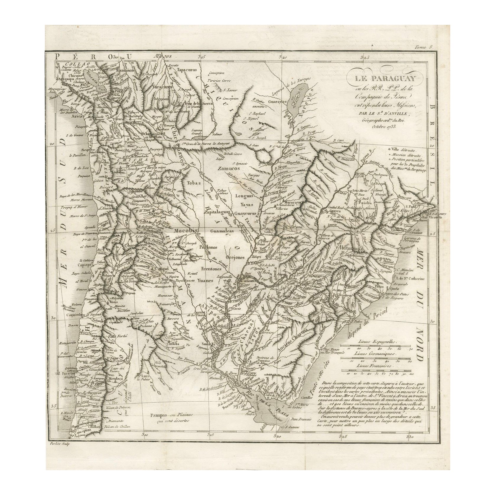
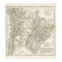
View AllAntique Map of Paraguay and Jesuit Missions by D’Anville, 1733
Located in Langweer, NL
Antique Map of Paraguay and Jesuit Missions by D’Anville, 1733
Antique map titled Le Paraguay. This finely detailed copperplate engraving depicts the region of Paraguay along with ...
Category
Antique Mid-18th Century French Maps
Materials
Paper
Antique Map of Northern Brazil by Bonne, c.1780
Located in Langweer, NL
Antique map titled 'Carte de la Partie Septentrionale du Bresil.' Detailed map of the northern portion of Brazil from Bahia to French Guiana, showing the eastern Amazon interior rivers, Mission Territories, Goyza and the coastal regions, including coastal currents. Source unknown, to be determined. Artists and Engravers: Rigobert Bonne (1727-1795 ) was one of the most important cartographers of the late 18th century. In 1773 he succeeded Jacques Bellin as Royal Cartographer to France in the office of the Hydrographer at the Depôt de la Marine. Working in his official capacity Bonne compiled some of the most detailed and accurate maps of the period. Bonne's work represents an important step in the evolution of the cartographic ideology away from the decorative work of the 17th and early 18th century towards a more detail oriented and practical aesthetic. With regard to the rendering of terrain Bonne maps...
Category
Antique 18th Century Maps
Materials
Paper

$119 Sale Price
20% Off
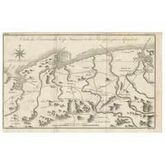
Antique Map of the Environs of Cap-Français, Saint-Domingue, c.1760
Located in Langweer, NL
Antique Map of the Environs of Cap-Français, Saint-Domingue, c.1760
This detailed 18th-century copperplate engraving, titled Carte des Environs du Cap Français et des Paroisses qui ...
Category
Antique Early 18th Century French Maps
Materials
Paper
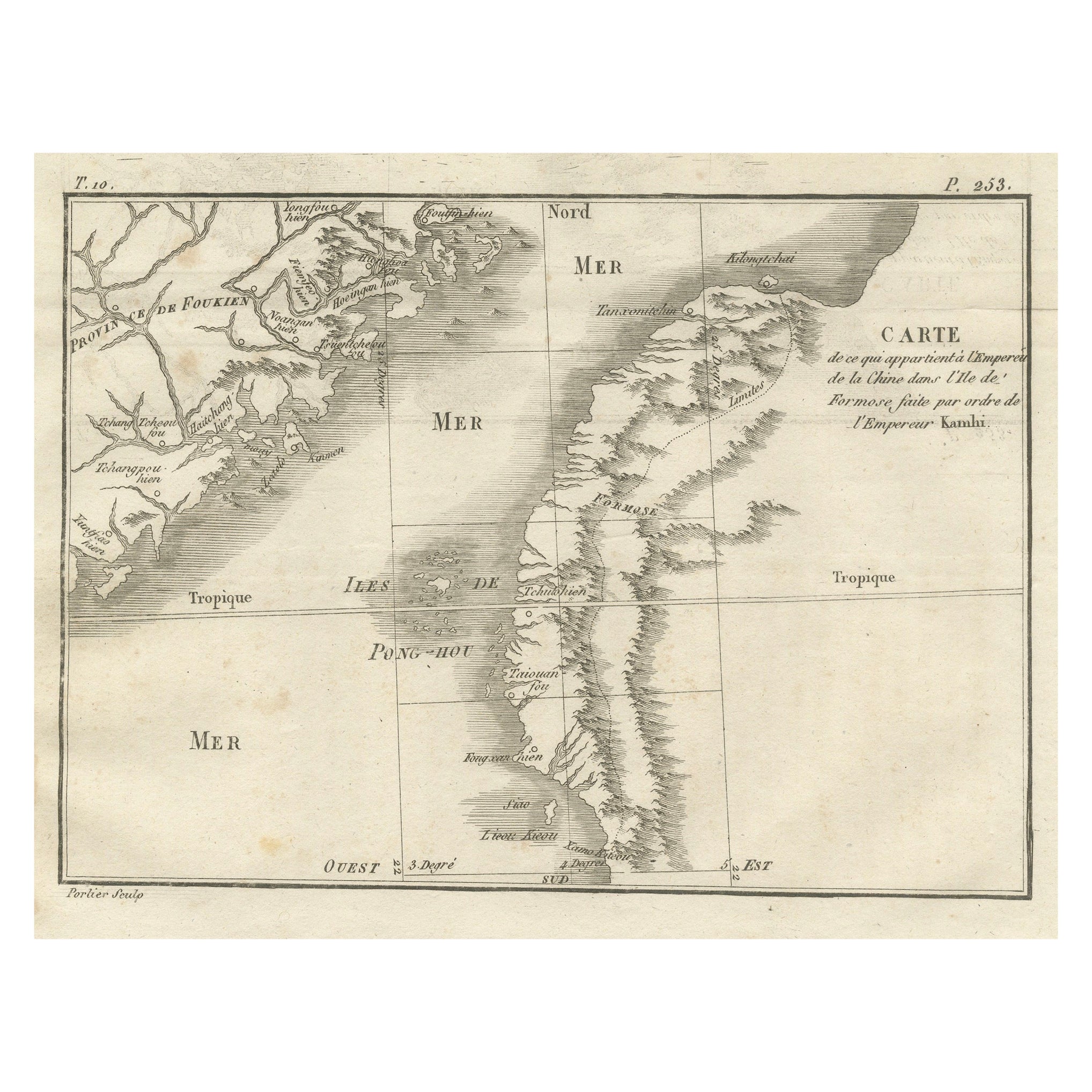
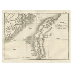
Map of Formosa and Pescadores – French Jesuit Engraving by Portier, c.1790
Located in Langweer, NL
Map of Formosa and Pescadores – French Jesuit Engraving by Portier, c.1790
This antique French map, engraved by Portier around 1790, depicts the island of Formosa (modern Taiwan), t...
Category
Antique Late 18th Century French Maps
Materials
Paper
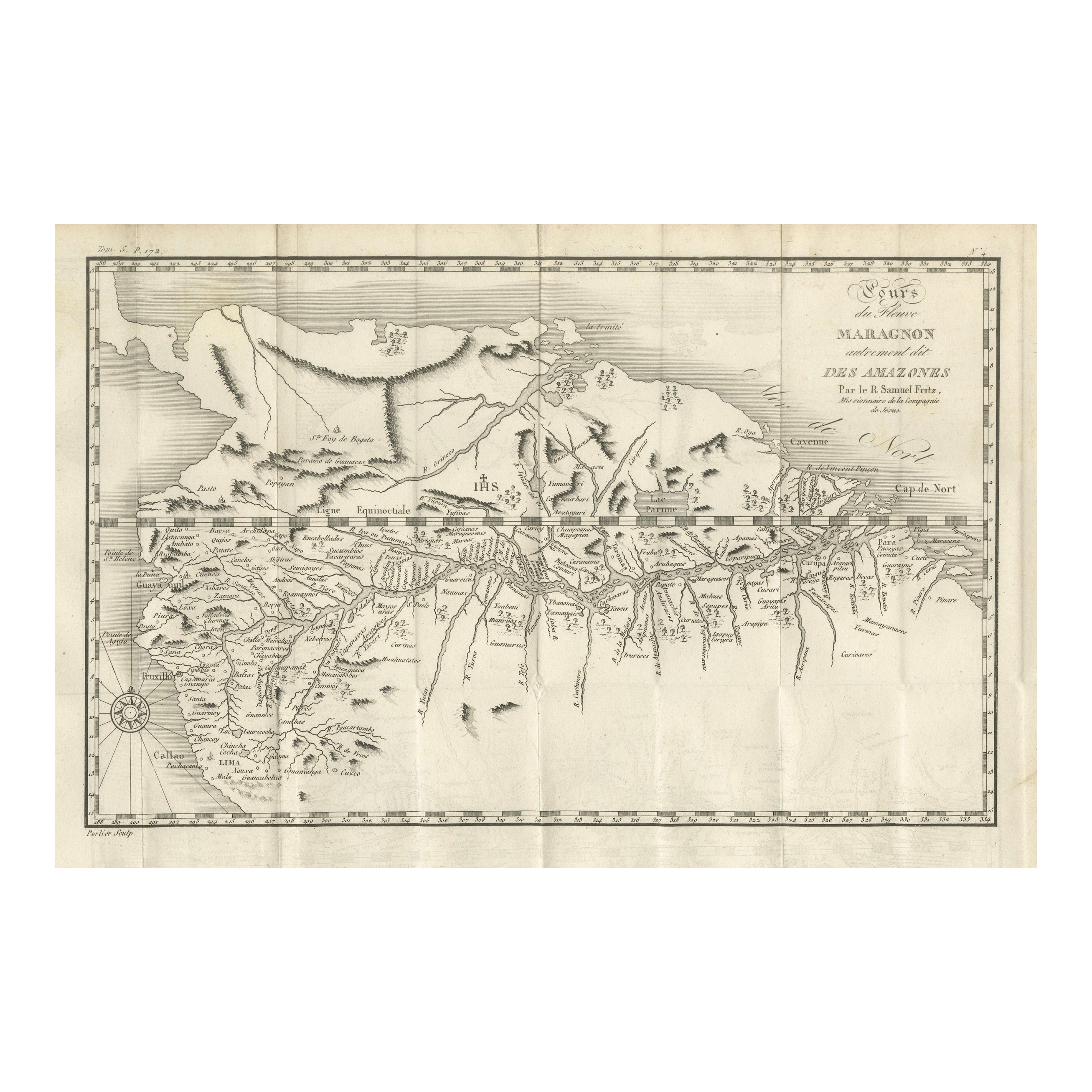
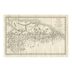
Antique Map of the Amazon River – Maragnon or River of the Amazons, c.1760
Located in Langweer, NL
Map of the Amazon River – “Cours du Fleuve Maragnon autrement dit des Amazones”, c.1760
This 18th-century copperplate map, titled Cours du Fleuve Maragnon autrement dit des Amazones...
Category
Antique Mid-18th Century French Maps
Materials
Paper
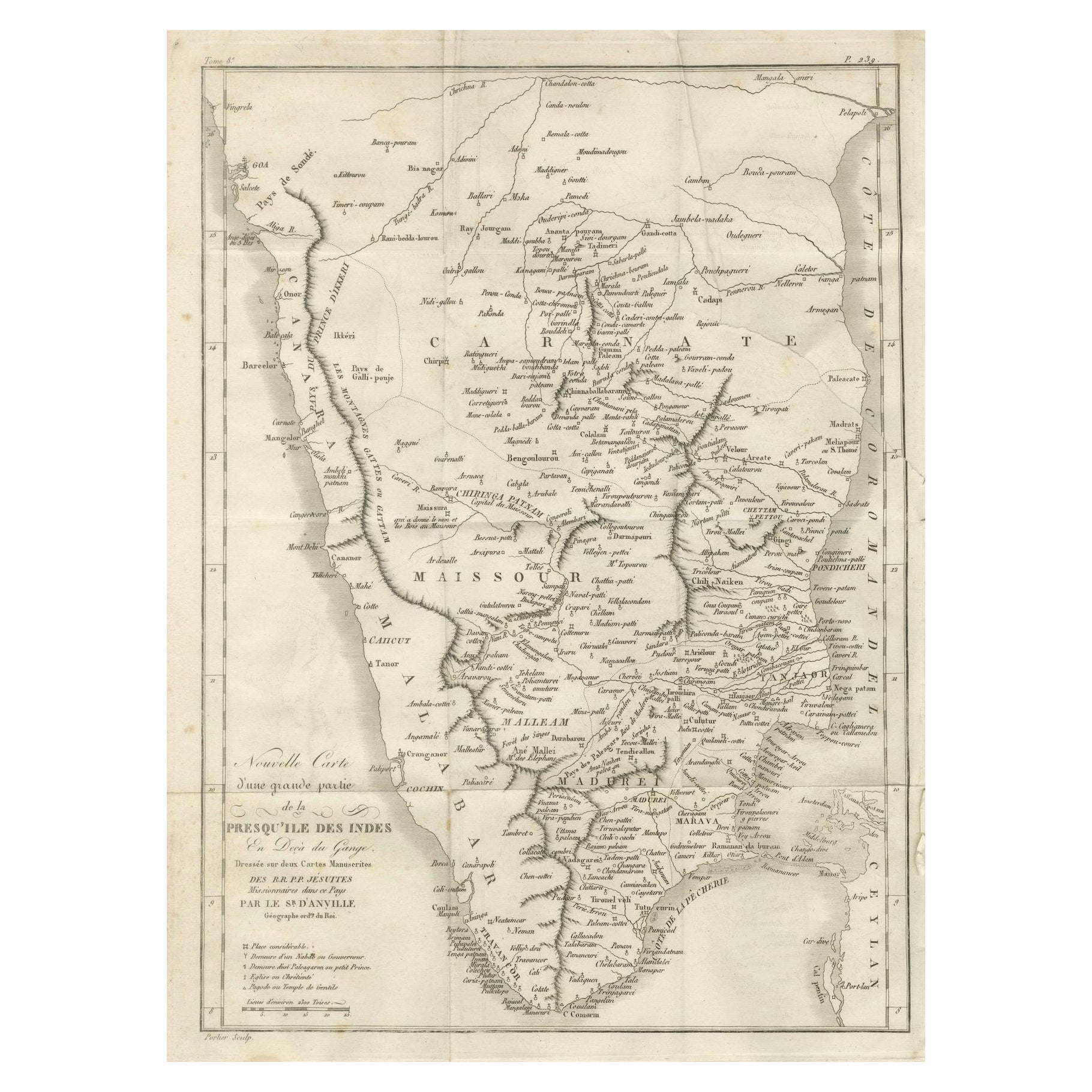
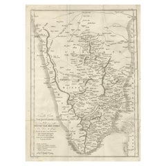
Antique Map of Southern India – French Engraving by D’Anville, 18th Century
Located in Langweer, NL
This finely detailed antique map presents the southern portion of India, engraved in the 18th century by the renowned French cartographer Jean-Baptiste Bourguignon d’Anville.
It de...
Category
Antique Late 18th Century French Maps
Materials
Paper
You May Also Like
Li Governi di Borgogna - Ancient Map - 1777
Located in Roma, IT
Li Governi di Borgogna is an original black and white etching on paper, printed by Antonio Zatta in Venice, 1777.
Original Title: Li Governi di Borgogna della Franca Contea e del Ly...
Category
1770s Modern Landscape Prints
Materials
Etching

Antique 1765 Wine Country Folding Map of France, Bordeau etc.
Located in Paonia, CO
Route du Carosse de Bordeaux, part de Paris tous les Mardis a 11 matin. a et pafse 1765 is a comprehensive map with two routes through the wine country of France starting in Paris going south...
Category
1760s Other Art Style Landscape Prints
Materials
Etching

Map of South America - Original Etching - Late 19th Century
Located in Roma, IT
This Map of South America is an etching realized by an anonymous artist.
The state of preservation of the artwork is good with some small diffused stains.
Sheet dimension: 41.5 x 27
The artwork represents the map South America...
Category
Late 19th Century Modern Figurative Prints
Materials
Etching
Southerlandia Map - Etching by Johannes Janssonius - 1650
By Johannes Janssonius
Located in Roma, IT
Southerlandia Map is an ancient map realized in 1650 by Johannes Janssonius (1588-1664).
The Map is Hand-colored etching, with coeval watercoloring.
Good conditions.
From Atlantis...
Category
1650s Modern Figurative Prints
Materials
Etching

Map of Campaign of 1814 - Etching by Pierre François Tardieu - 1837
Located in Roma, IT
Map of Campaign of 1814 is an Etching realized by Pierre François Tardieu in 1837.
Good conditions.
The artwork is realized in a well-balanced composition. the artwork and belongs ...
Category
1830s Modern Figurative Prints
Materials
Lithograph

Original Antique Map of South America. C.1780
Located in St Annes, Lancashire
Great map of South America
Copper-plate engraving
Published C.1780
Two small worm holes to left side of map
Unframed.
Category
Antique Early 1800s English Georgian Maps
Materials
Paper

More Ways To Browse
Antique Peru
Antique Peruvian Furniture
Peruvian Antiques
Pair Of Danish Chairs
Veneer Dining Tables
1970 Italian Armchair
Furniture Uk
House Of Denmark Table And Chairs
Louis Marble Top Side Table
Antique Russian Rugs
Baker Furniture By
For Kids
Sterling Silver Flatware Set Service For 12
Tufted Bar
Pair Of French Antique Armchairs
1970s Brass Glass Coffee Table
Antique Column Base
Charles Rennie Mackintosh For Cassina