Want more images or videos?
Request additional images or videos from the seller
1 of 11
Moll
s Famous "Beaver Map"
$22,500List Price
About the Item
- Dimensions:Height: 54 in (137.16 cm)Width: 37.5 in (95.25 cm)
- Place of Origin:
- Period:
- Date of Manufacture:18th century
- Condition:Good with some minor imperfections, later color.
- Seller Location:San Francisco, CA
- Reference Number:Seller: C112-11stDibs: U1108048552761
About the Seller
5.0
Recognized Seller
These prestigious sellers are industry leaders and represent the highest echelon for item quality and design.
Platinum Seller
Premium sellers with a 4.7+ rating and 24-hour response times
Established in 1982
1stDibs seller since 2008
381 sales on 1stDibs
Typical response time: 1 hour
Associations
The Art and Antique Dealers League of AmericaAntiques Associations Members
Authenticity Guarantee
In the unlikely event there’s an issue with an item’s authenticity, contact us within 1 year for a full refund. DetailsMoney-Back Guarantee
If your item is not as described, is damaged in transit, or does not arrive, contact us within 7 days for a full refund. Details24-Hour Cancellation
You have a 24-hour grace period in which to reconsider your purchase, with no questions asked.Vetted Professional Sellers
Our world-class sellers must adhere to strict standards for service and quality, maintaining the integrity of our listings.Price-Match Guarantee
If you find that a seller listed the same item for a lower price elsewhere, we’ll match it.Trusted Global Delivery
Our best-in-class carrier network provides specialized shipping options worldwide, including custom delivery.You May Also Like
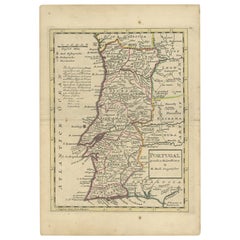
Antique Map of Portugal by Moll, 1727
Located in Langweer, NL
Antique map Portugal titled 'Portugal Agreeable to Modern History'. Detailed map of Portugal showing major routes, waterways, arch bishoprics, bis...
Category
Antique 18th Century Maps
Materials
Paper
Antique Map of Denmark by Moll
circa 1730
By Herman Moll
Located in Langweer, NL
Antique map titled 'Denmark, agreeable to Modern History'. Uncommon map of Denmark by Herman Moll, published, circa 1730.
Category
Antique Mid-18th Century Maps
Materials
Paper

Antique Map of Part of Germany by Moll, c.1740
Located in Langweer, NL
Antique map Germany titled 'The North West Part of Germany; Containing ye Dominions of ye Arch: and El: of Cologne, Westphalia, / Juliers, Cleeves,...
Category
Antique 18th Century Maps
Materials
Paper

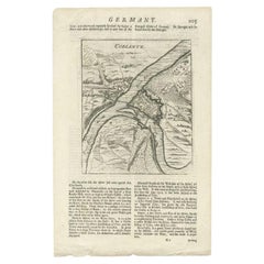
Antique Map of the Koblentz Region by Moll, 1695
By Herman Moll
Located in Langweer, NL
Antique map Koblentz titled 'Coblentz'. Rare antique map of the Koblentz region in Germany. On verso, an antique map of the Mont Royal fortress, Germany. Originates from 'Thesaurus Geographicus. A New Body of Geography: or a Compleat Description of the Earth 'by H. Moll.
Artists and Engravers: Herman Moll...
Category
Antique 17th Century Maps
Materials
Paper
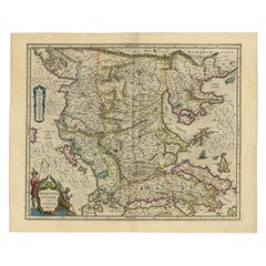
Antique Map of Macedonia by the Famous Mapmaker Blaeu, c.1650
Located in Langweer, NL
Antique map titled 'Macedonia, Epirus et Achaia'.
Ornated with a nice allegoric cartouche, one ship and a milage scale. Macedonia is shown in the centre of the map. With many detai...
Category
Antique 17th Century Maps
Materials
Paper
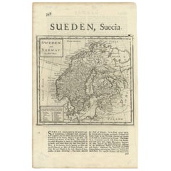
Antique Map of Sweden and Norway by H. Moll, circa 1715
Located in Langweer, NL
Beautiful and rare map of Sweden and Norway including English text. This map most likely originates from 'The Compleat geographer, or, The chorography and topography of all the known...
Category
Antique Early 18th Century British Maps
Materials
Paper
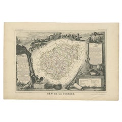
Antique Map of the Famous French Wine Area of Correze, 1854
Located in Langweer, NL
Antique map titled 'Dépt. da la Corrèze'. Map of the French department of Correze, France. This area of France is known for its production of straw wine, a sweet red or white wine. T...
Category
Antique 19th Century Maps
Materials
Paper
Antique Map of Lower Silesia of The Famous Mapmaker Blaeu, c.1650
Located in Langweer, NL
Antique map titled 'Ducatus Silesiae Wolanus'. \
Antique map depicting lower Silesia with the cities of Wolow (Wohlau), Winsko (Winzig), Herrnstadt, Chobie (Koben), Lubin (Lüben), R...
Category
Antique 17th Century Maps
Materials
Paper
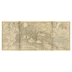
Rare 1730 Roman Empire Map by Moll - Detailed and Engraved Masterpiece
Located in Langweer, NL
An Historical Map of the Roman Empire and the Neighbouring Barbarous Nations by Herman Moll - Circa 1730
This grand and historically significant map of the Roman Empire was create...
Category
Antique 1730s Maps
Materials
Paper
$1,681
H 22.25 in W 47.25 in D 0.01 in
Antique Map of Artois in the North of France by Famous Mapmaker Blaeu, c.1640
Located in Langweer, NL
Antique map titled 'Artesia Comitatus Artois'. Map of Artois or Artesia, France. Artois is former province located in the northwestern part of France, boarding Belgium (Flanders) on ...
Category
Antique 17th Century Maps
Materials
Paper
$576
H 19.69 in W 23.43 in D 0 in
More From This Seller
View AllScarce U.S. Coast Survey Map Depicting Entrance to San Francisco Bay Dated 1856
Located in San Francisco, CA
A fine example of the 1856 U.S. Coast lithographic survey nautical chart of the entrance to San Francisco bay and the city. Published in 1856 by the Office of the Coast Survey the of...
Category
Antique Mid-19th Century American Maps
Materials
Paper

$780 Sale Price
47% Off
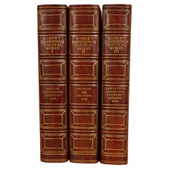
The Poetic and Dramatic Works of Robert Browning Bound in Leather and Cloth
Located in San Francisco, CA
An attractive leather bound set of the poetic and dramatic works of Robert Browning (1812-1889) published in 1906 by Houghton Mifflin and Company, New York and Boston. Top edges gilt...
Category
Early 20th Century American Books
Materials
Paper, Leather
Histoire De Russie Published 1797 with 36 Engraved Plates by E.A. David
Located in San Francisco, CA
The History of Russia in 2 volumes published 1797, in French.
A lovely 2 volume first edition titled "Histoire de Russie" by Blin de Sainmore, French poet, playwright and historian (...
Category
Antique Late 18th Century French Books
Materials
Leather, Paper
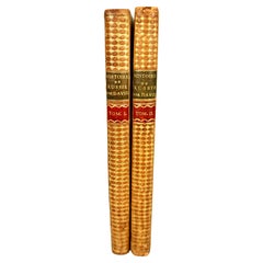
$780 Sale Price
20% Off
Group of Seven Vintage Books on Fishing
Located in San Francisco, CA
A group of seven books on fishing as follows:
• The Fisherman's World by Charles Waterman published Random House, no date
• The Trout and the Fly by Clarke and Goddard published Doub...
Category
Early 20th Century American Books
Materials
Paper
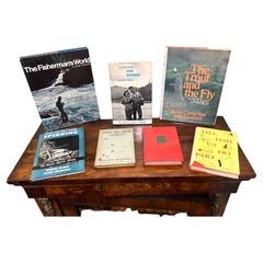
$280 / set
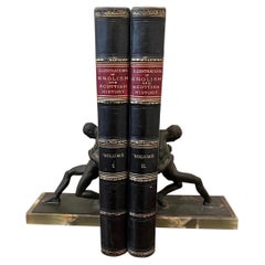
Illustrations of English and Scottish History in 2 Leatherbound Quarto Volumes
Located in San Francisco, CA
"Pictures and Royal Portraits Illustrative of English and Scottish History, from the Introduction of Christianity to the Present Time" by Thomas Archer. Blackie & Son, n.d. in two qu...
Category
Antique Late 19th Century English Victorian Books
Materials
Leather, Paper
John Morier, The Adventures of Hajji Baba of Ispahan in 3 Volumes London: 1824
Located in San Francisco, CA
"The Adventures of Hajji Baba of Ispahan", 12mo., complete in 3 purple full polished calf bound volumes, with gilt page ends and blue marbled endpapers, 1st edition. Written by James...
Category
Antique Early 19th Century English Regency Books
Materials
Leather, Paper
Still Thinking About These?
All Recently ViewedMore Ways To Browse
Antique Russian Rugs
For Kids
Sterling Silver Flatware Set Service For 12
Tufted Bar
Pair Of French Antique Armchairs
1970s Brass Glass Coffee Table
Charles Rennie Mackintosh For Cassina
Glass Salt
Italian Modern Silver Vases
Vintage Resin Tables
Antique English Country Furniture
Blue Kilim Vintage
Contemporary Side Tables And Stools
Decorative Wall Plate
Mid Century Modern Corner Chair
Dining Tables With Brass Inlay
Oak Mid Century Armchair
Solid Wood Side Table Stool