Items Similar to Monomotapa Empire Map – East Africa, French Cartography, c.1740

Want more images or videos?
Request additional images or videos from the seller
1 of 10
Monomotapa Empire Map – East Africa, French Cartography, c.1740
$680.96
£508.92
€570
CA$939.42
A$1,028.96
CHF 541.75
MX$12,280.31
NOK 6,904.09
SEK 6,311.38
DKK 4,344.62
About the Item
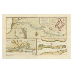
Monomotapa Empire Map – East Africa, French Cartography, c.1740
This important French map depicts the legendary Empire of Monomotapa and the surrounding regions of southeastern Africa, encompassing present-day Mozambique, Zimbabwe, and inland southern Africa. The map is titled “Empire du Monomotapa et États Voisins” and was engraved after the work of Guillaume Delisle and other French authorities. It was published in Paris around 1740 as part of the official French geographical corpus.
The map reflects early European attempts to understand and delineate the political geography of interior southern Africa, a region long associated in European thought with gold wealth, powerful inland kingdoms, and ancient trade networks. Monomotapa, often linked by Europeans to biblical Ophir, appears prominently, alongside neighboring states, river systems, mountain ranges, and coastal trading centers connected to the Indian Ocean world.
The Zambezi river system is carefully traced inland, linking coastal Mozambique to the interior, while named kingdoms, territories, and ethnographic regions are distinguished through subtle hand coloring. Coastal areas show Portuguese trading posts and forts, underscoring the strategic and commercial rivalry between European powers in East Africa. The cartography blends empirical coastal knowledge with speculative interior geography, making the map a compelling document of 18th-century European geographic thought.
Decoratively, the map balances clarity and elegance. A large engraved title cartouche anchors the lower right, while the coastline, rivers, and political boundaries are highlighted with contemporary hand color. Latitude and longitude markings provide a scientific framework, reflecting the influence of Delisle’s reformist cartographic approach, which emphasized accuracy and critical source comparison.
This map is particularly desirable for collectors of African cartography, early colonial history, and maps illustrating the transition from myth-based geography to empirically grounded mapping. It also serves as a powerful contextual counterpart to more focused coastal and harbor charts of Mozambique and the Indian Ocean.
Condition report
Good condition overall. Light age toning consistent with period. Central vertical fold as issued. Minor scattered spots and light surface marks. Original hand coloring. Plate mark visible. Margins intact.
Framing tips
This map benefits from a generous off-white or light sand-colored mat to visually separate the detailed interior geography from the frame. A medium to dark wood frame complements the hand coloring and gives the piece a scholarly, museum-style presence. Particularly effective when displayed as the central piece in an East Africa cartographic grouping.
Technique: Copper engraving with contemporary hand color
Maker: After Guillaume Delisle, France, c.1740
- Dimensions:Height: 9.65 in (24.5 cm)Width: 12.8 in (32.5 cm)Depth: 0.01 in (0.2 mm)
- Materials and Techniques:Paper,Engraved
- Place of Origin:
- Period:1740-1749
- Date of Manufacture:circa 1740
- Condition:Good condition overall. Light age toning consistent with period. Central vertical fold as issued. Minor scattered spots and light surface marks. Original hand coloring. Plate mark visible. Margins intact.
- Seller Location:Langweer, NL
- Reference Number:Seller: BG-14128-41stDibs: LU3054348016812
About the Seller
5.0
Recognized Seller
These prestigious sellers are industry leaders and represent the highest echelon for item quality and design.
Platinum Seller
Premium sellers with a 4.7+ rating and 24-hour response times
Established in 2009
1stDibs seller since 2017
2,806 sales on 1stDibs
Typical response time: 1 hour
- ShippingRetrieving quote...Shipping from: Langweer, Netherlands
- Return Policy
More From This Seller
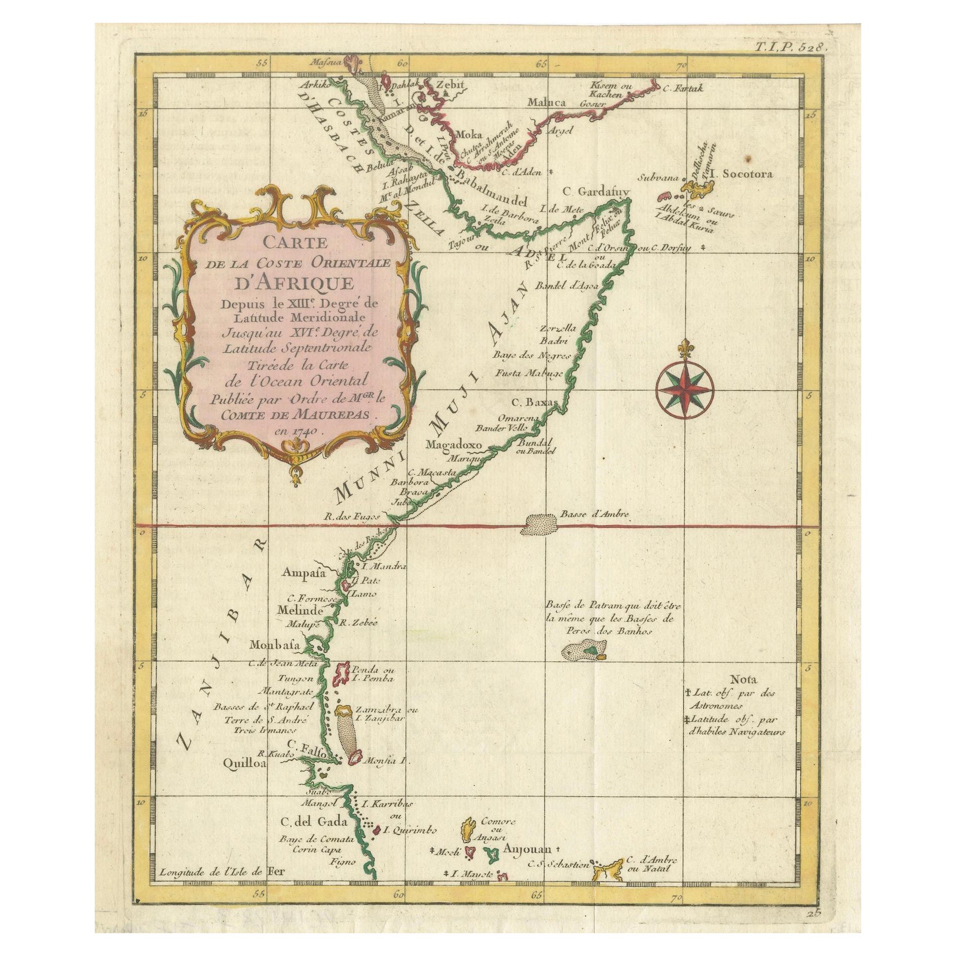
View AllEast African Coast – French Map by Bellin, Zanzibar to Arabia, 1740
Located in Langweer, NL
East African Coast – French Map by Bellin, Zanzibar to Arabia, 1740
This important French map depicts the eastern coast of Africa from Mozambique and Zanzibar northward to the Horn ...
Category
Antique 1740s French Maps
Materials
Paper
Antique Map of the Environs of Cap-Français, Saint-Domingue, c.1760
Located in Langweer, NL
Antique Map of the Environs of Cap-Français, Saint-Domingue, c.1760
This detailed 18th-century copperplate engraving, titled Carte des Environs du Cap Français et des Paroisses qui ...
Category
Antique Early 18th Century French Maps
Materials
Paper
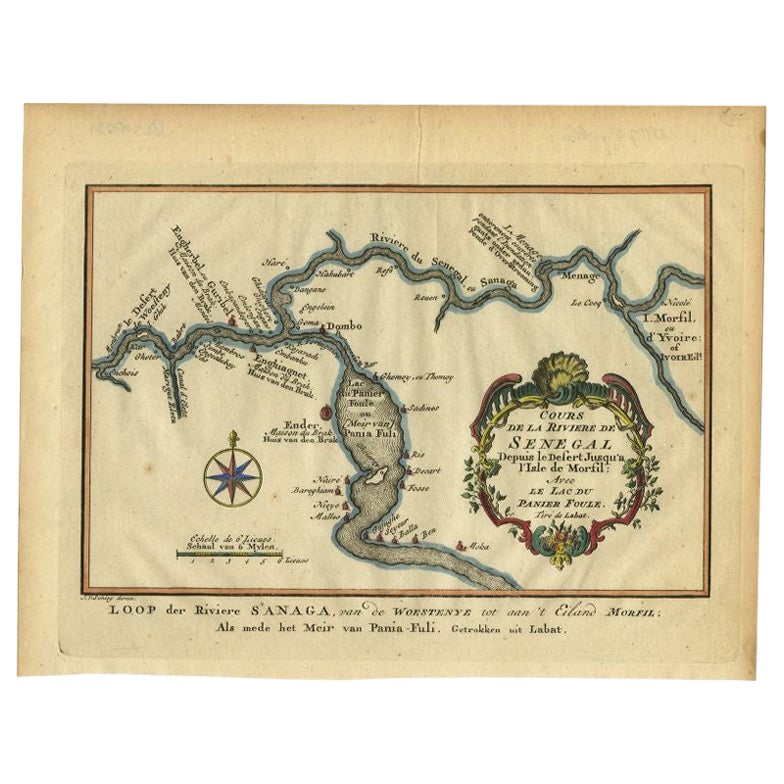
Antique Map of the Course of the Sanaga River by Van Schley, 1747
Located in Langweer, NL
Antique map titled 'Cours de la Riviere de Senegal (..) - Loop der Riviere Sanaga (..)'. Original antique map of the course of the Sanaga River that forms the border between Senegal ...
Category
Antique 18th Century Maps
Materials
Paper
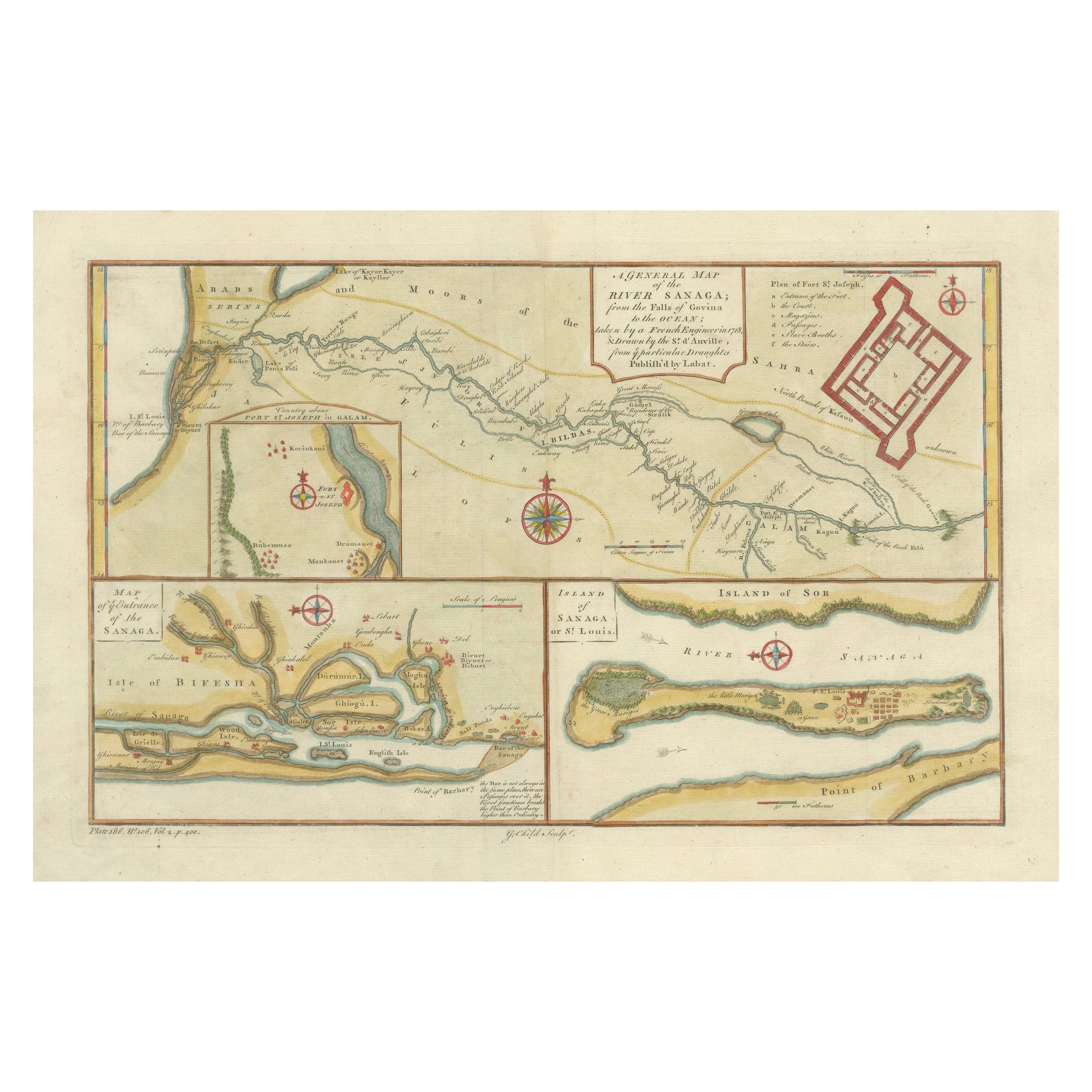
River Sanaga, West Africa – Elegant French Exploration Map, c.1750
Located in Langweer, NL
Nubia and Abyssinia – Venetian Map of Northeast Africa, Zatta, 1784
This detailed late-18th-century map depicts Nubia and Abyssinia, covering large parts of present-day Sudan, Ethio...
Category
Antique 1750s Italian Maps
Materials
Paper
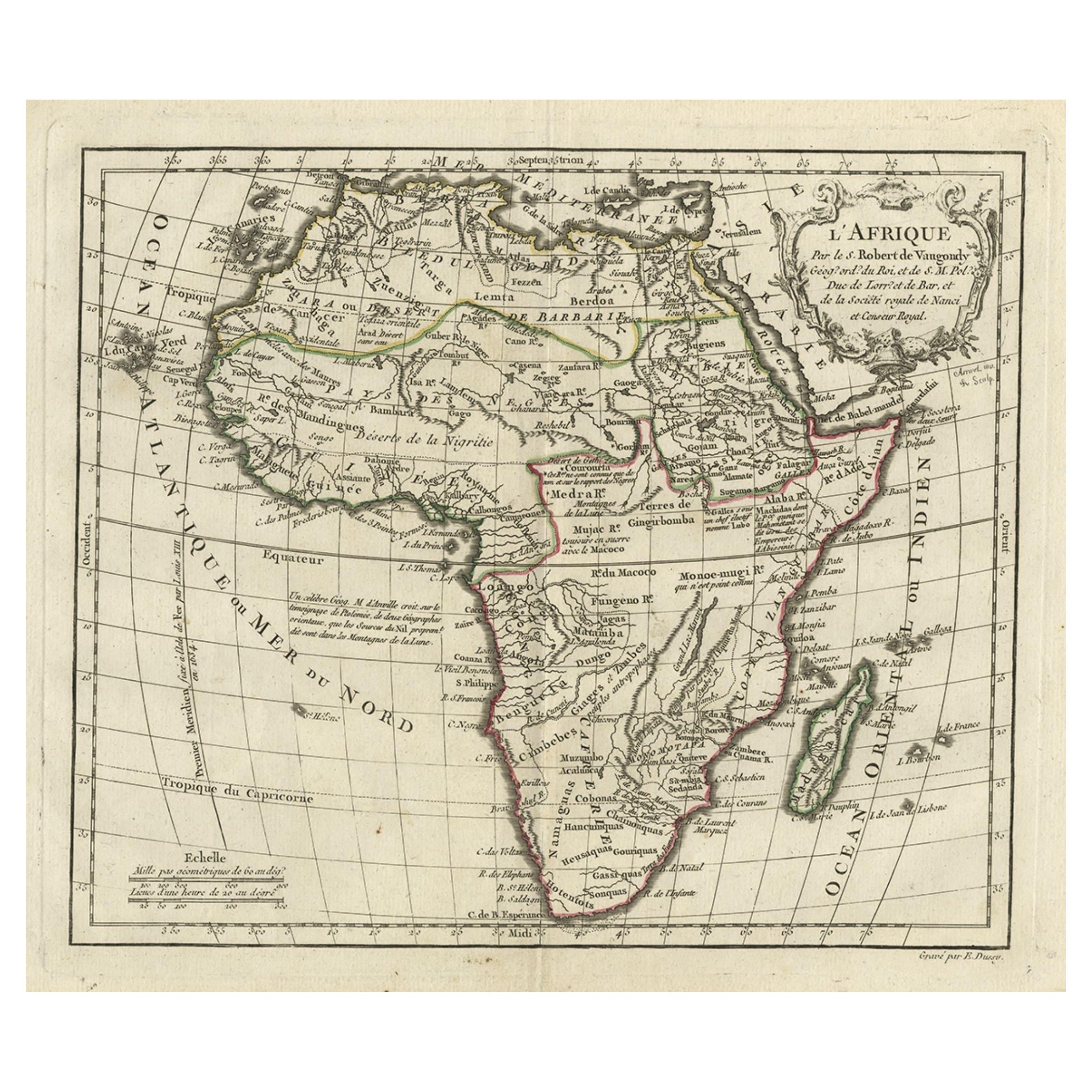
Antique Map of Africa with French Cartouche and Scale, c.1780
Located in Langweer, NL
Antique map titled 'L'Afrique'. Original antique map of Africa. With beautiful title cartouche and scale. Source unknown, to be determined.
Artists and Engravers: Gilles Robert de...
Category
Antique 18th Century Maps
Materials
Paper
$334 Sale Price
20% Off
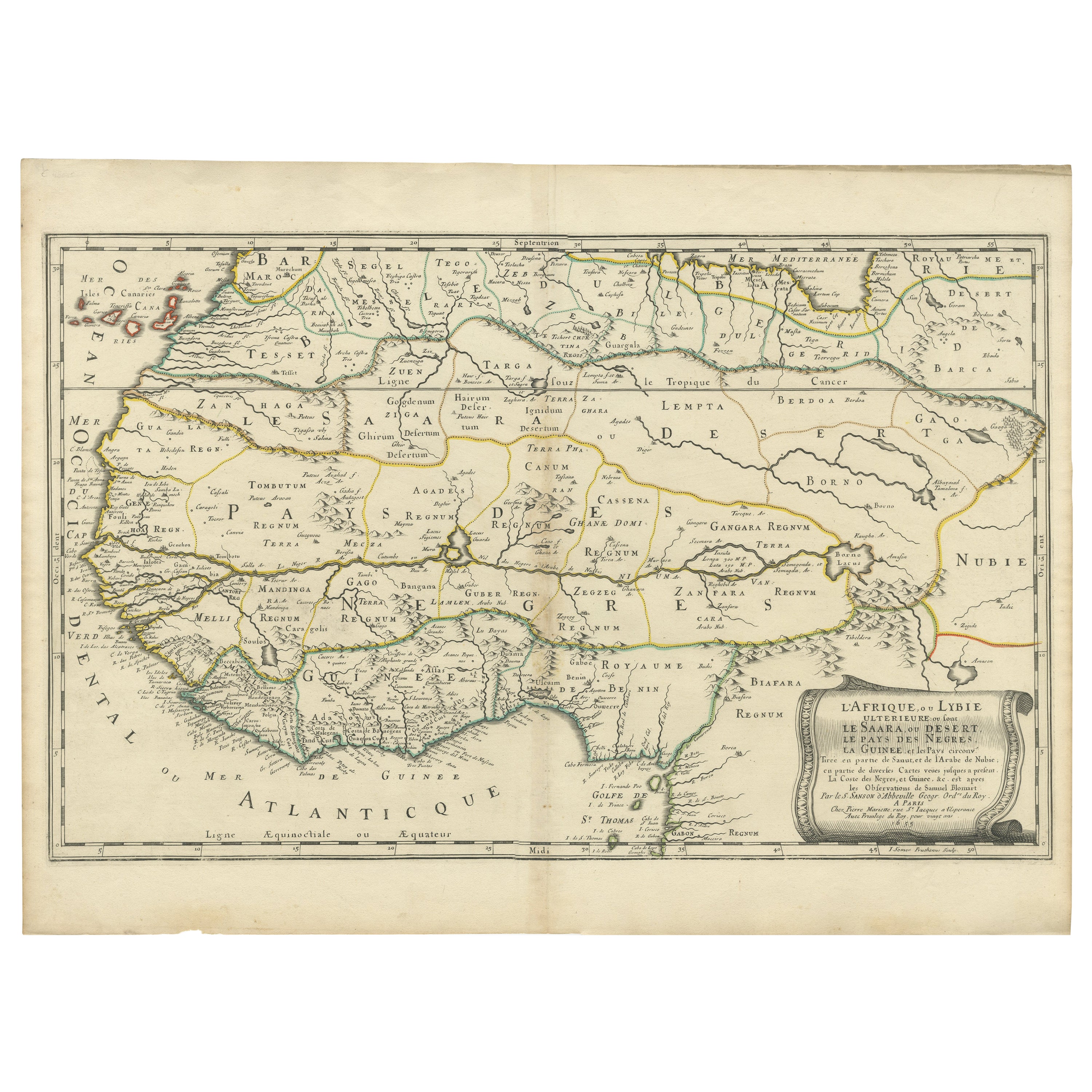
Attractive Antique Map of Western Africa with Lots of Details on the Coast, 1655
Located in Langweer, NL
Title: "L'Afrique, ou Lybie ulterieure ou sont le Saara, ou Desert, le pays des negres, la Guinee, et les Pays circonv. Tirée en partie de Sanut, et de l'Arabe de Nubie; en partie de diverses Cartes veües jusques a present".
Handsome map of Western Africa filled with information, much of it spurious, in the Sahara Desert, the Niger River and the coast of Guinea. Of particular interest are several incomplete rivers in the desert regions that appear and then disappear. The map is beautifully engraved with a title cartouche fashioned in the form of an oriental carpet.
The map shows a fantastic level of detail near the coastlines, which extends into legend and Ptolemaic myth in the interior of the continent. Detail is particularly extensive in Guinea and the Gold and Ivory Coasts. The Niger River is traced to its Malian lakes. The Mediterranean is barely visible in the northern part of the map. This map incorporates the discoveries made by Samuel Blommaert, who was director of the Dutch West Indies Company, in addition to traveling extensively to Africa and settling the oldest land deed...
Category
Antique 1650s Maps
Materials
Paper
You May Also Like
West Africa Entitled "Guinea Propria": An 18th Century Hand Colored Homann Map
By Johann Baptist Homann
Located in Alamo, CA
This is a scarce richly hand colored copper plate engraved map of Africa entitled "Guinea Propria, nec non Nigritiae vel Terrae Nigrorum Maxima Pars" by Johann Baptist Homann (1664-1...
Category
Antique Mid-18th Century German Maps
Materials
Paper

West Africa: 18th Century Hand-colored Homann Map Entitled "Guinea Propria"
By Johann Baptist Homann
Located in Alamo, CA
This is a scarce richly hand colored copper plate engraved map of Africa entitled "Guinea Propria, nec non Nigritiae vel Terrae Nigrorum Maxima Pars" by Johann Baptist Homann (1664-1...
Category
1740s Other Art Style Prints and Multiples
Materials
Engraving

Antique French Map of Asia Including China Indoneseia India, 1783
Located in Amsterdam, Noord Holland
Very nice map of Asia. 1783 Dedie au Roy.
Additional information:
Country of Manufacturing: Europe
Period: 18th century Qing (1661 - 1912)
Condition: Overall Condition B (Good Used)...
Category
Antique 18th Century European Maps
Materials
Paper

$486 Sale Price
40% Off
Africa: A Large 17th Century Hand-colored Map By Sanson and Jaillot
By Nicholas Sanson d
Abbeville
Located in Alamo, CA
This large original hand-colored copperplate engraved map of Africa entitled "L'Afrique divisee suivant l'estendue de ses principales parties ou sont distingues les uns des autres, L...
Category
1690s Landscape Prints
Materials
Engraving

Africa: A Large 17th Century Hand-Colored Map by Sanson and Jaillot
By Nicolas Sanson
Located in Alamo, CA
This large original hand-colored copperplate engraved map of Africa entitled "L'Afrique divisee suivant l'estendue de ses principales parties ou sont distingues les uns des autres, L...
Category
Antique 1690s French Maps
Materials
Paper

"Africa Vetus": A 17th Century Hand-colored Map By Sanson
By Nicholas Sanson d
Abbeville
Located in Alamo, CA
This original hand-colored copperplate engraved map of Africa entitled "Africa Vetus, Nicolai Sanson Christianiss Galliar Regis Geographi" was originally created by Nicholas Sanson d...
Category
1690s Landscape Prints
Materials
Engraving
