Items Similar to Mount Sinai
St. Catherine
s – Antique Map of the Sinai Monasteries, 1776

Want more images or videos?
Request additional images or videos from the seller
1 of 10
Mount Sinai
St. Catherine
s – Antique Map of the Sinai Monasteries, 1776
$501.57
£374.78
€420
CA$691.84
A$757.89
CHF 398.92
MX$9,045.63
NOK 5,085.27
SEK 4,648.71
DKK 3,200.07
About the Item
Mount Sinai
St. Catherine's – Antique Map of the Sinai Monasteries, 1776
Description:
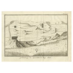
This finely engraved antique map depicts the mountainous region of the Sinai Peninsula, focusing on Mount Sinai (Berg Sinai), Mount Horeb, and the famed St. Katharina-berg (Mount Saint Catherine), as well as the surrounding valleys, peaks, and monastic sites. Titled in Dutch: "Grondteekening der Bergen Sinai, Horeb, S. Katharina enz. alsmede der Kloosters en Plaatsen omtrent den berg Sinai," it translates to: “Ground plan of the Mountains Sinai, Horeb, St. Catherine etc., including the monasteries and places around Mount Sinai.”
The map originates from the 1776 Dutch edition of Richard Pococke’s monumental travel work Beschryving van het Oosten ("Description of the East"), translated and annotated by Ernst Willem Cramerus. Pococke’s documentation of the Near East was one of the most detailed of the 18th century, combining topographical, archaeological, and biblical observations.
Among the prominent features on the map are:
* *Berg Sinai* (Mount Sinai), the traditional site where Moses received the Ten Commandments
* *St. Katharina-berg*, the highest peak in Egypt
* *Dal Raha* and *Dal Melgah*, surrounding valleys
* *Berg Horeb* and *Mosesberg*, biblical landmarks
* Various small structures denoting *kloosters* (monasteries), cells, and ancient ruins
A compass rose orients the viewer, and mountain ranges are rendered in stylized relief, with pathways and key locations marked by letters corresponding to a legend (possibly included in the text volume). This engraving serves not only as a geographical guide but as a valuable historical and devotional document reflecting Enlightenment-era exploration and religious scholarship.
Condition report:
Very good condition with some minor age-related toning and a central fold as issued. Paper is strong, and margins are intact. Plate mark clearly visible. No tears or repairs noted.
Framing tips:
A subtle cream mat and natural wood or black frame would elegantly enhance this piece. Consider float-mounting to reveal the plate edges, preserving its antique authenticity.
Technique: Engraving
Maker: Richard Pococke, London (Dutch edition published 1776)
- Dimensions:Height: 10.24 in (26 cm)Width: 13.39 in (34 cm)Depth: 0.01 in (0.2 mm)
- Materials and Techniques:Paper,Engraved
- Place of Origin:
- Period:
- Date of Manufacture:1776
- Condition:Very good condition with some minor age-related toning and a central fold as issued. Paper is strong, and margins are intact. Plate mark clearly visible. No tears or repairs noted.
- Seller Location:Langweer, NL
- Reference Number:Seller: BG-14102-611stDibs: LU3054346057892
About the Seller
5.0
Recognized Seller
These prestigious sellers are industry leaders and represent the highest echelon for item quality and design.
Platinum Seller
Premium sellers with a 4.7+ rating and 24-hour response times
Established in 2009
1stDibs seller since 2017
2,806 sales on 1stDibs
Typical response time: 1 hour
- ShippingRetrieving quote...Shipping from: Langweer, Netherlands
- Return Policy
More From This Seller
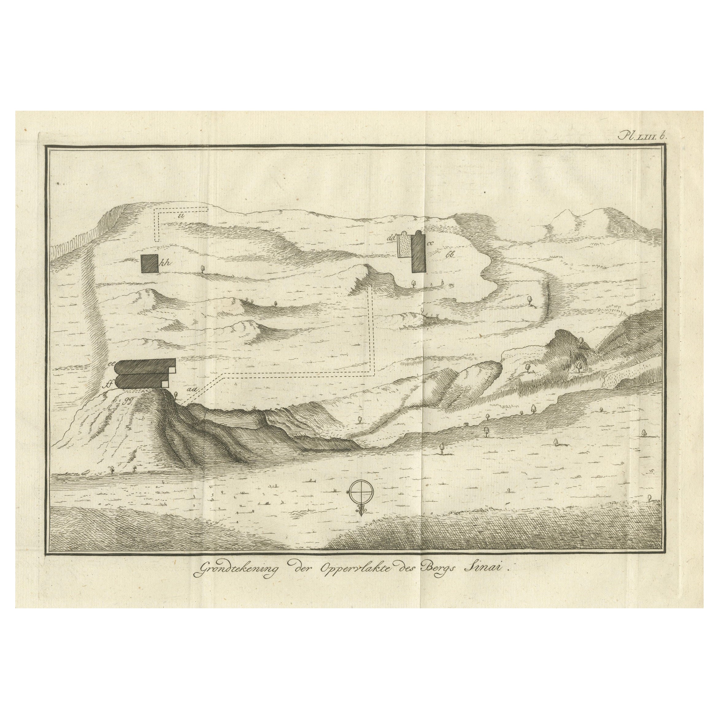
View AllTopographic Map of Mount Sinai Summit – Antique Engraving by Pococke, 1776
Located in Langweer, NL
Topographic Map of Mount Sinai Summit – Antique Engraving by Pococke, 1776
This antique engraving offers a rare and detailed view of the summit plateau of Mount Sinai, titled "Grond...
Category
Antique Late 18th Century Dutch Maps
Materials
Paper
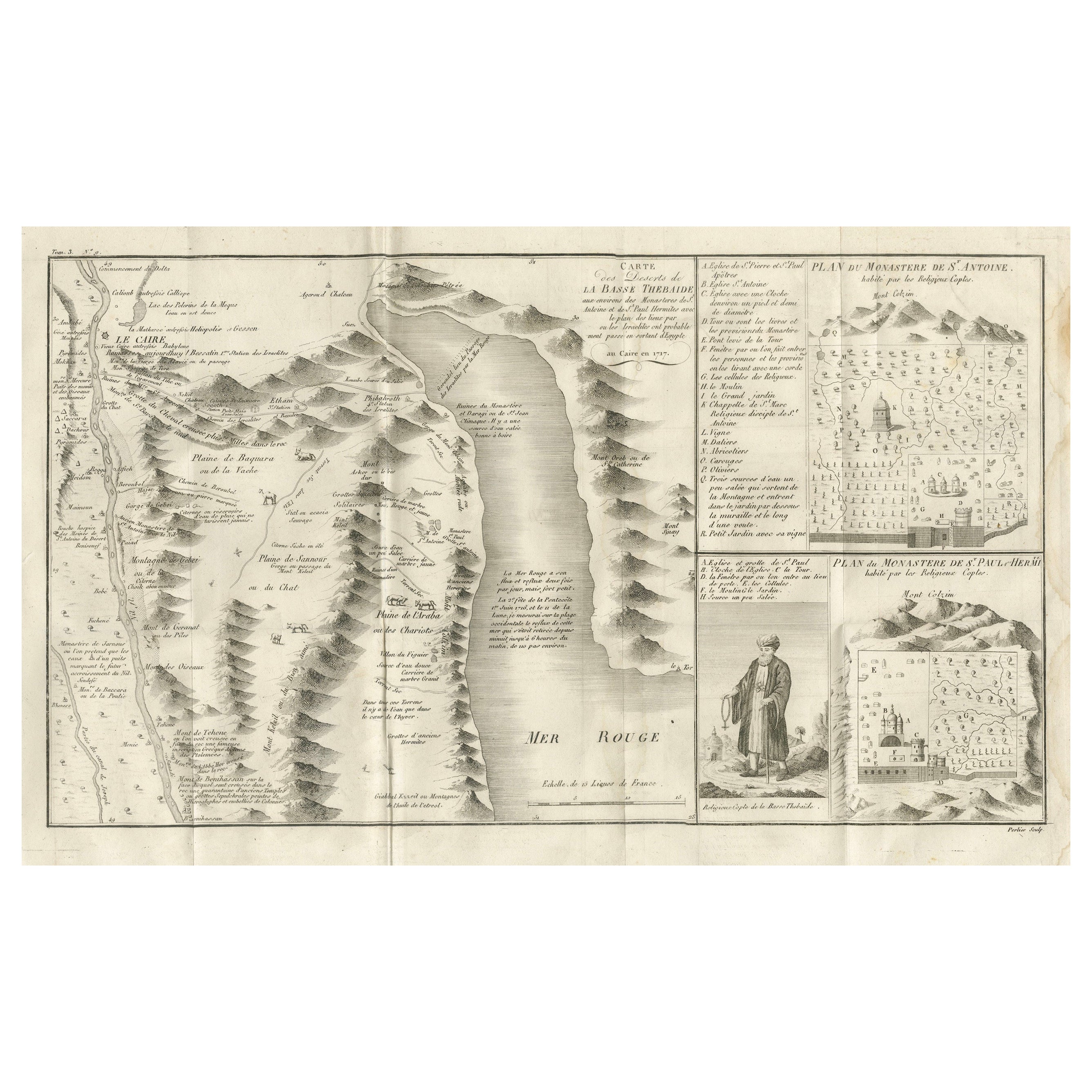
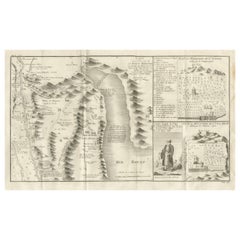
Antique Map of the Red Sea
Basse Thebaide with Monastery Plans, Egypt, 1777
Located in Langweer, NL
Antique Map of the Red Sea & Basse Thebaide with Monastery Plans, Egypt, 1777
This finely detailed 18th-century engraving depicts the coastal and inland geography of the Red Sea reg...
Category
Antique Late 18th Century French Maps
Materials
Paper
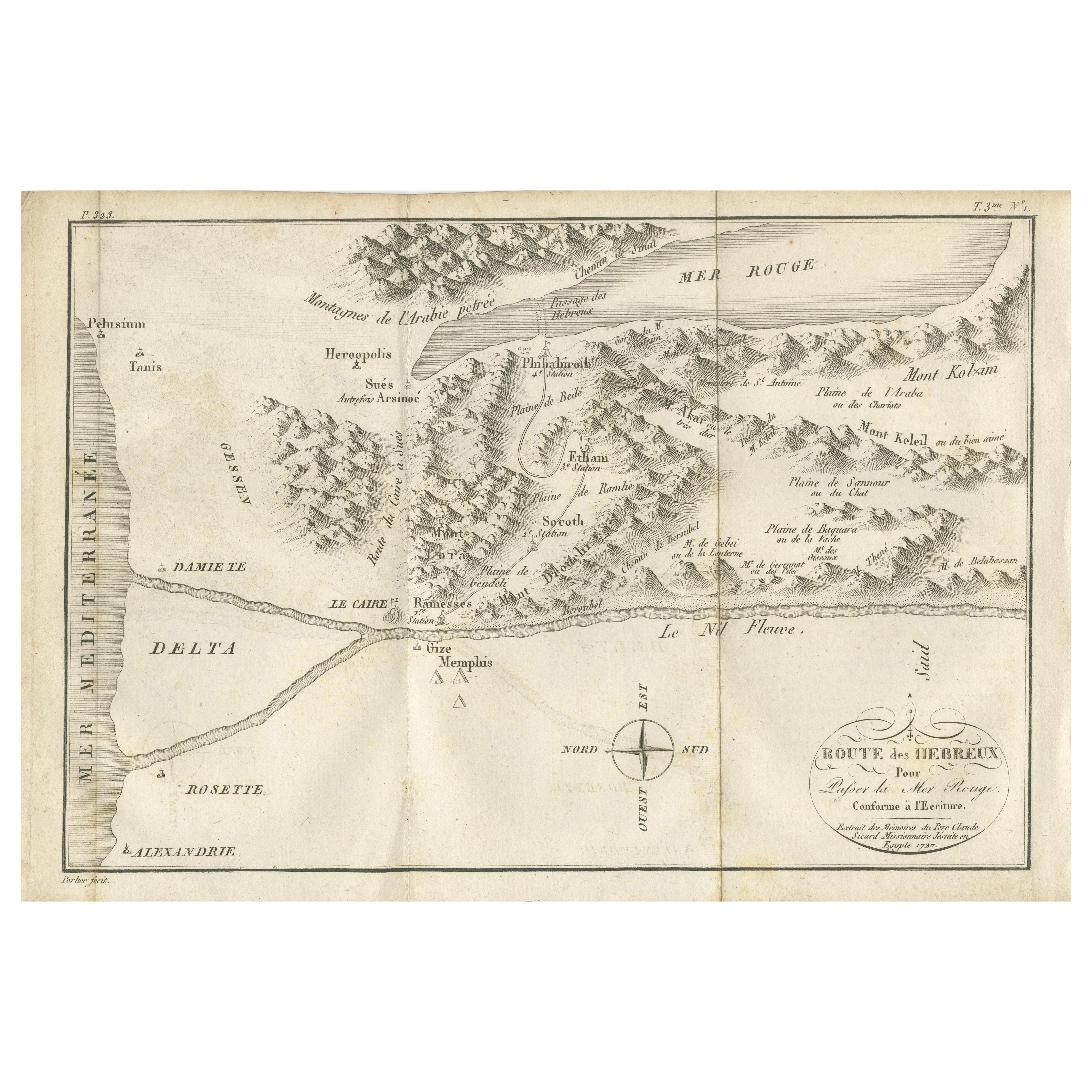
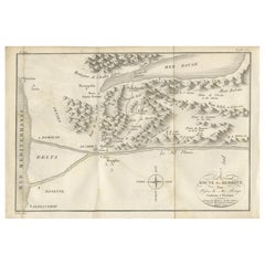
Antique Map of the Route of the Hebrews – Egypt to the Red Sea, 1720
Located in Langweer, NL
Map of the Route of the Hebrews – Egypt to the Red Sea, 1720
This finely engraved 18th-century map, titled Route des Hébreux pour passer la Mer Rouge, conforme à l’Écriture, traces ...
Category
Antique Early 18th Century French Maps
Materials
Paper
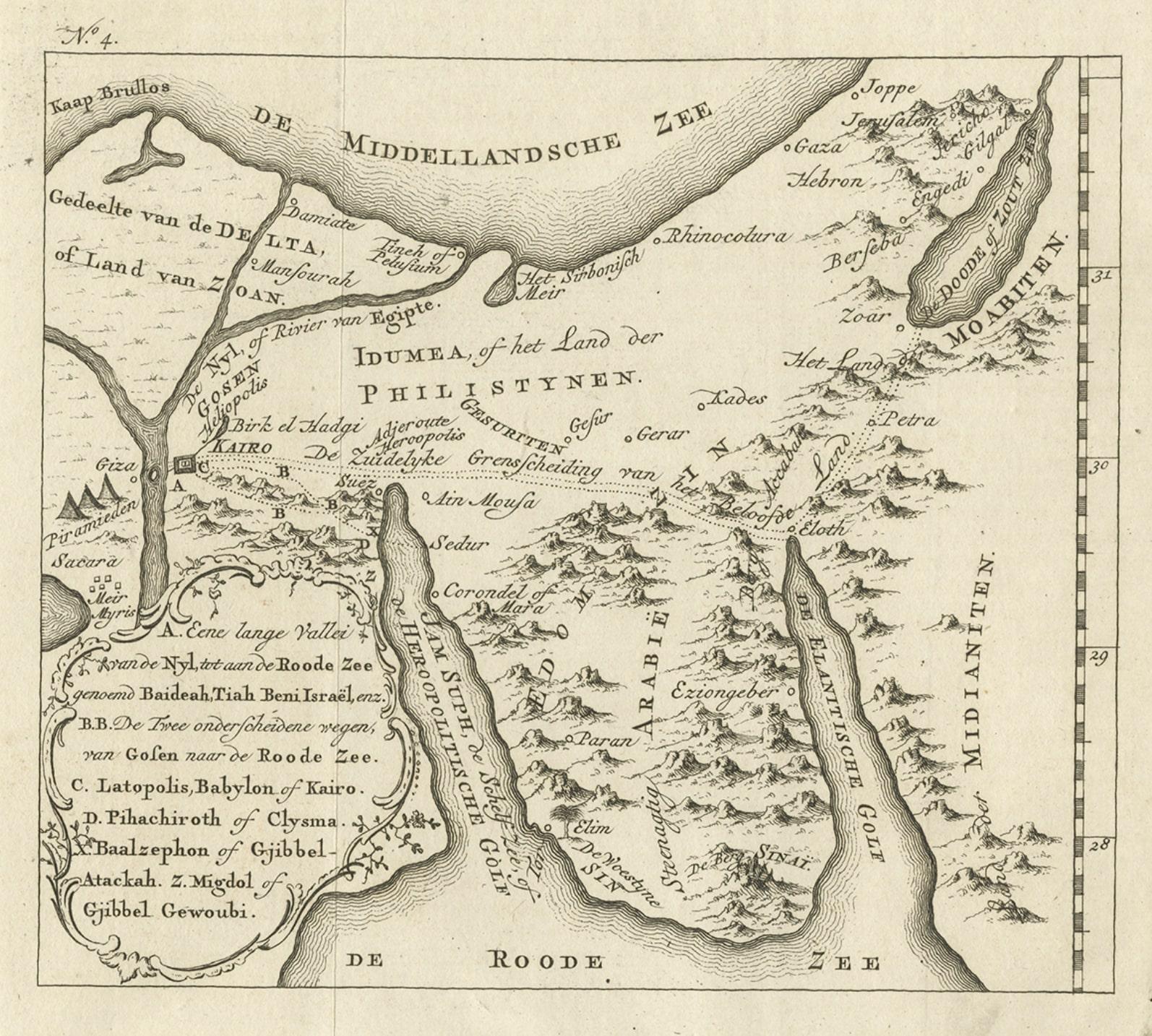
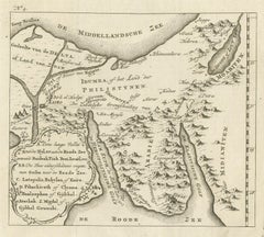
Antique Map of Edom, an Ancient Kingdom in Transjordan, 1773
Located in Langweer, NL
Antique print titled 'Idumea, of thet Land der Philistynen'. Old map of Edom, an ancient kingdom in Transjordan located between Moab to the northeast, the Arabah to the west and the ...
Category
Antique 18th Century Maps
Materials
Paper
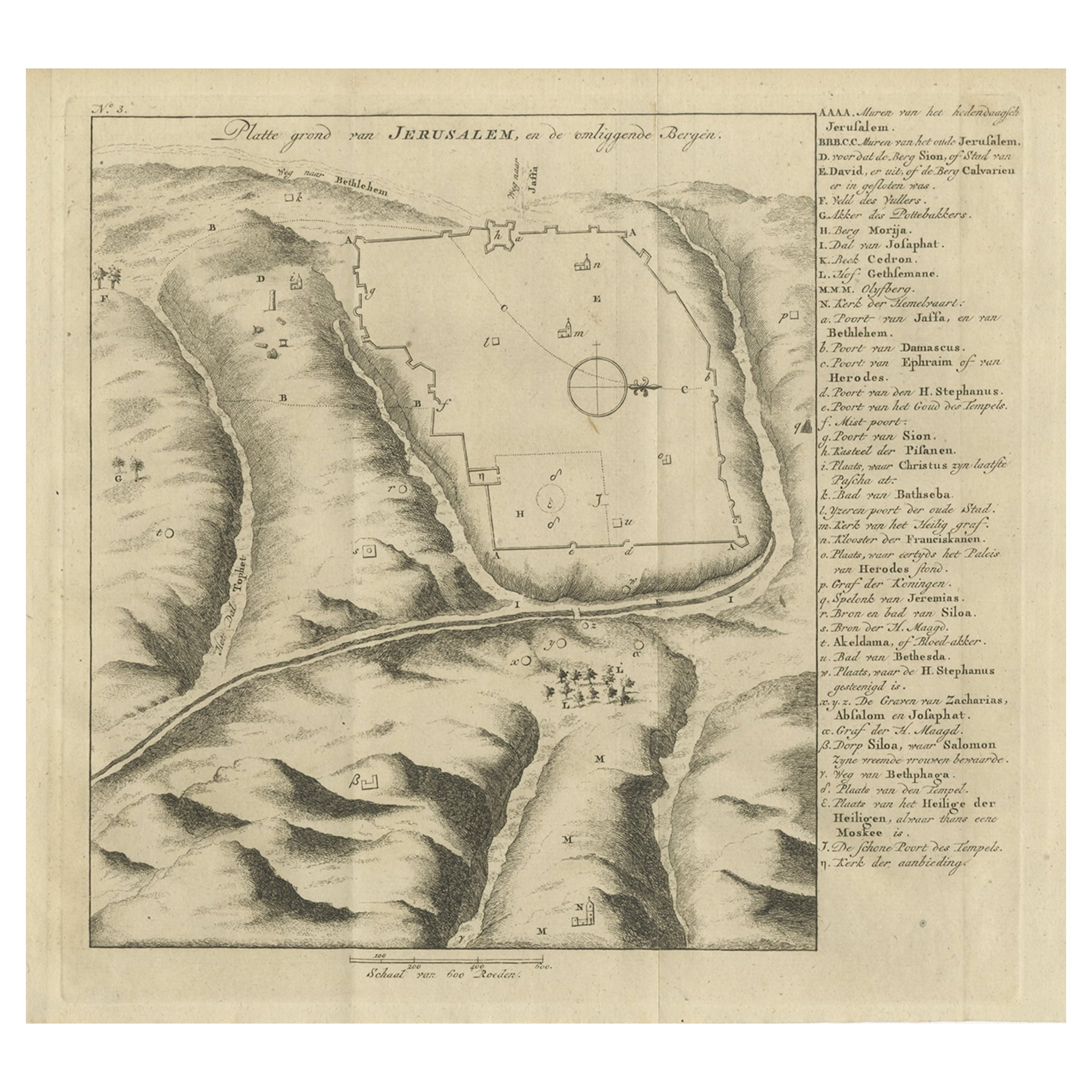
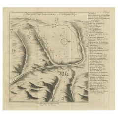
Antique Engraving of a Map or Plan of Jerusalem and Surrounding Mountains, 1773
Located in Langweer, NL
Antique map titled 'Platte grond van Jerusalem, en de omliggende Bergen'. Plan of the city of Jerusalem, with surrounding mountains. Originates from the first Dutch editon of an inte...
Category
Antique 18th Century Maps
Materials
Paper
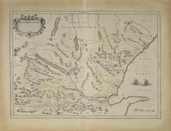
Detailed Original Old Map of the Southern Region of the Kingdom of Algiers 1773
Located in Langweer, NL
Antique map titled 'Kaart van het Zuidelyk Gedeelte van het Ryk Algiers'.
Old map of the southern region of the Kingdom of Algiers, Algeria. Originates from the first Dutch edito...
Category
Antique 18th Century Maps
Materials
Paper

You May Also Like
Map of Nubia and Abissinia - Original Etching by Antonio Zatta - 1784
Located in Roma, IT
This Map of Nubia and Abissinia is an etching realized by Antonio Zatta in Venice in 1784.
The state of preservation of the artwork is good expect for the worn paper with some littl...
Category
1770s Landscape Prints
Materials
Etching

Antique Map - Mar Di Athiopia - Etching by Johannes Janssonius - 1650s
By Johannes Janssonius
Located in Roma, IT
Antique Map - Mar Di Athiopia is an antique map realized in 1650 by Johannes Janssonius (1588-1664).
The Map is Hand-colored etching, with coeval watercolorang.
Good conditions wit...
Category
1650s Modern Figurative Prints
Materials
Etching

Map of Scotland - Etching by Johannes Blaeu - 1650s
Located in Roma, IT
Map of Scotland is an geographic map realized by Johannes Blaeu.
Etching, printed in 1660 ca.
Copper engraving, colored (coeval coloring), on paper, with center fold;
Latin text. ...
Category
1650s Modern Figurative Prints
Materials
Etching
$447 Sale Price
20% Off
Southerlandia Map - Etching by Johannes Janssonius - 1650
By Johannes Janssonius
Located in Roma, IT
Southerlandia Map is an ancient map realized in 1650 by Johannes Janssonius (1588-1664).
The Map is Hand-colored etching, with coeval watercoloring.
Good conditions.
From Atlantis...
Category
1650s Modern Figurative Prints
Materials
Etching

Original Antique Map of Ancient Greece, Achaia, Corinth, 1786
Located in St Annes, Lancashire
Great map of Ancient Greece. Showing the region of Thessaly, including Mount Olympus
Drawn by J.D. Barbie Du Bocage
Copper plate engraving by P.F Tardieu
Original hand color...
Category
Antique 1780s French Other Maps
Materials
Paper

Original Antique Map of Ancient Greece- Boeotia, Thebes, 1787
Located in St Annes, Lancashire
Great map of Ancient Greece. Showing the region of Boeotia, including Thebes
Drawn by J.D. Barbie Du Bocage
Copper plate engraving by P.F T...
Category
Antique 1780s French Other Maps
Materials
Paper

More Ways To Browse
Antique Engravings London
Monastery Furniture
Beni Ourain Rugs
Glass Top Wood Base Coffee Tables
T Chair
Pair Of Danish Chairs
Veneer Dining Tables
1970 Italian Armchair
Furniture Uk
House Of Denmark Table And Chairs
Louis Marble Top Side Table
Antique Russian Rugs
Baker Furniture By
For Kids
Sterling Silver Flatware Set Service For 12
Tufted Bar
Pair Of French Antique Armchairs
1970s Brass Glass Coffee Table