Items Similar to Arctic
Greenland Map – Northern Hemisphere, North Pole, Leiden 1876


Want more images or videos?
Request additional images or videos from the seller
1 of 9
Arctic
Greenland Map – Northern Hemisphere, North Pole, Leiden 1876
$344.10
£256.89
€290
CA$478.06
A$514.22
CHF 274.82
MX$6,061.22
NOK 3,464.78
SEK 3,167.47
DKK 2,210.13
About the Item
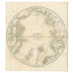
Title: Northern Hemisphere Map Centered on the North Pole, Leiden 1876
Description:
This 19th-century Dutch map titled “Noordpoolkaart” (Map of the North Pole) was published in 1876 in the 'Nieuwe Hand-Atlas der Aarde in haren Tegenwoordigen Toestand' by M. Frijlink, revised by A. van Otterloo, and printed by D. Noothoven van Goor in Leiden. The circular projection presents the northern hemisphere viewed from above the Arctic, offering a fascinating perspective on the geography of Europe, Asia, and North America during an era when much of the polar region remained unexplored.
The map uses fine lithographic lines with delicate hand-coloring to outline political boundaries—yellow for the Americas, pink for Asia, and blue for Europe. It shows the Arctic Ocean surrounded by Greenland, Scandinavia, Siberia, Alaska, and northern Canada, along with early routes of exploration and major northern islands. This projection highlights the relative proximity of continents across the polar regions and was designed to help students and scholars understand global geography beyond the equatorial view.
Produced as part of Frijlink’s educational atlas, this chart reflects the scientific curiosity of the late 19th century, when expeditions sought to uncover the mysteries of the North Pole. The clarity and elegance of the engraving show the high standards of Dutch lithography, with a balance of accuracy and aesthetic restraint typical of academic cartography of the time.
Condition report:
Good condition with light overall toning and faint foxing near the margins. Original center fold as issued. The printed surface remains crisp, and colors are soft and well-preserved. No tears or repairs visible.
Framing tips:
This circular composition displays beautifully in a square or round-cut mount. A neutral off-white mat with a dark wood or black frame emphasizes the symmetry and calm tones. Ideal for display in a study or modern interior with an interest in exploration or geographic history.
Technique: Lithograph with original hand-coloring
Maker: M. Frijlink
A. van Otterloo, published by D. Noothoven van Goor, Leiden, 1876
- Dimensions:Height: 17.33 in (44 cm)Width: 21.66 in (55 cm)Depth: 0.01 in (0.2 mm)
- Materials and Techniques:
- Place of Origin:
- Period:
- Date of Manufacture:1876
- Condition:Good condition with light overall toning and faint foxing near the margins. Original center fold as issued. The printed surface remains crisp, and colors are soft and well-preserved. No tears or repairs visible.
- Seller Location:Langweer, NL
- Reference Number:Seller: BG-12788-41stDibs: LU3054347454272
About the Seller
5.0
Recognized Seller
These prestigious sellers are industry leaders and represent the highest echelon for item quality and design.
Platinum Seller
Premium sellers with a 4.7+ rating and 24-hour response times
Established in 2009
1stDibs seller since 2017
2,836 sales on 1stDibs
Typical response time: 1 hour
- ShippingRetrieving quote...Shipping from: Langweer, Netherlands
- Return Policy
More From This Seller
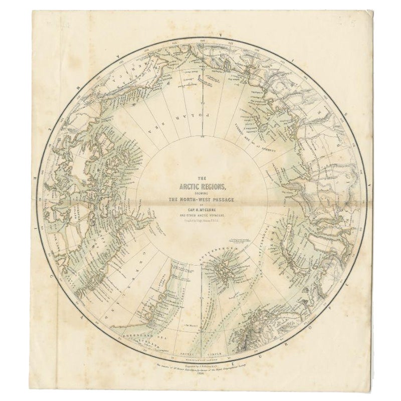
View AllAntique Map of the North Pole by Fullarton, 1856
Located in Langweer, NL
Antique map titled 'The Arctic Regions showing the North-West Passage of Captain R. McClure'. Old map of the North Pole, displaying the Northwest Passage di...
Category
Antique 19th Century Maps
Materials
Paper
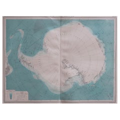
Antarctic Exploration Map by Noothoven van Goor with Early Discoveries, c.1876
Located in Langweer, NL
Antarctic Exploration Map by Noothoven van Goor with Early Discoveries, c.1876
This impressive 19th-century circular map of the Antarctic region was published in Leiden by D. Nootho...
Category
Antique 1870s Dutch Maps
Materials
Paper

Antique Map of the Northern Hemisphere by Lowry,
1852
Located in Langweer, NL
Antique map titled 'Perspective Projection of the World on the horizon of London'. Original map of the northern hemisphere. This map originates fro...
Category
Antique Mid-19th Century Maps
Materials
Paper

$142 Sale Price
20% Off
Greenland
the North Pole – Antique Northern Hemisphere Map by Tirion, c.1754
Located in Langweer, NL
Greenland & the North Pole – Antique Northern Hemisphere Map by Tirion, c.1754
ntique map titled 'Nieuwe Kaart van de Noord Pool na de alderlaatste ondekking int licht gebracht'. Ma...
Category
Antique Mid-18th Century Dutch Maps
Materials
Paper

$666 Sale Price
25% Off
Arctic Exploration – Greenland
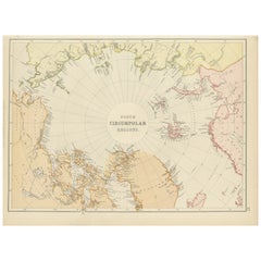
North Circumpolar Regions Map, 1882
Located in Langweer, NL
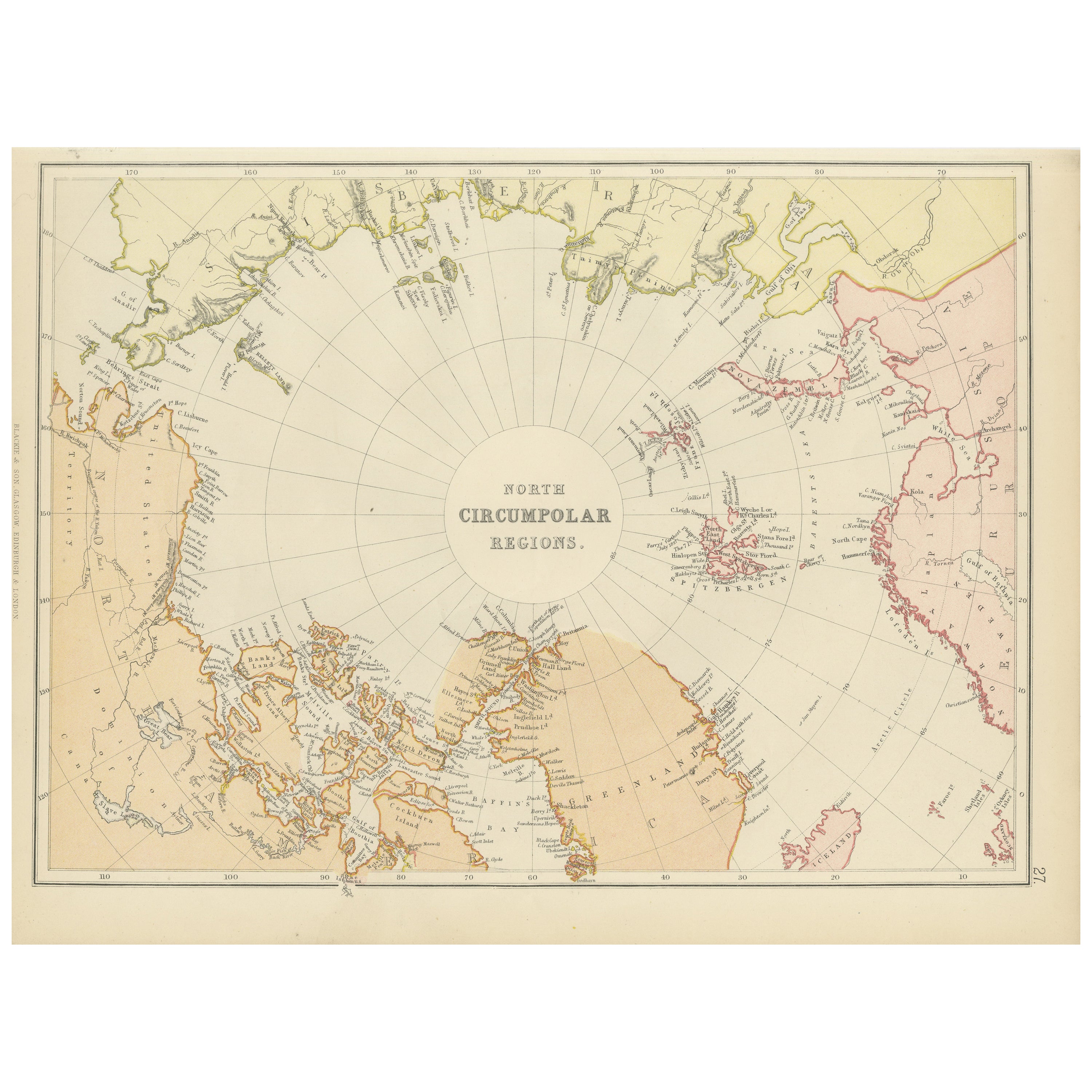
This map, extracted from the 1882 atlas by Blackie
Son, presents the North Circumpolar Regions in a projection centered on the North Pole, offering a unique view of the Arctic territories. The map's radial lines emanate from the pole, focusing on the northernmost parts of continents and the intricate archipelagos that are scattered across the Arctic Ocean.
The territories of Canada, Greenland, Northern Europe, Russia, and the northern extremities of Asia are portrayed with careful detail, highlighting the geography known to Victorian explorers. Notably, the map's color palette is subdued, with the cold regions depicted in pale hues, while coastlines and political boundaries are traced in warmer tones, providing a stark contrast that emphasizes the frigid environment.
The map likely served purposes both educational and navigational, capturing the extent of polar exploration at the time. Names of seas, straits, and islands honor explorers and patrons of the age of Arctic exploration, and the map also hints at the incomplete knowledge of the era, with some areas less detailed than others, reflecting the limits of exploration and cartographic knowledge of the Arctic region at that time.
Moreover, the map includes longitudinal and latitudinal markers, which would have been crucial for navigation and expedition planning. The inclusion of such detail illustrates the growing interest in polar exploration during the late 19th century...
Category
Antique 1880s British Maps
Materials
Paper
$265 Sale Price
20% Off
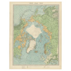
Vintage North Polar Chart – Greenland
Arctic Exploration Routes, 1903
Located in Langweer, NL
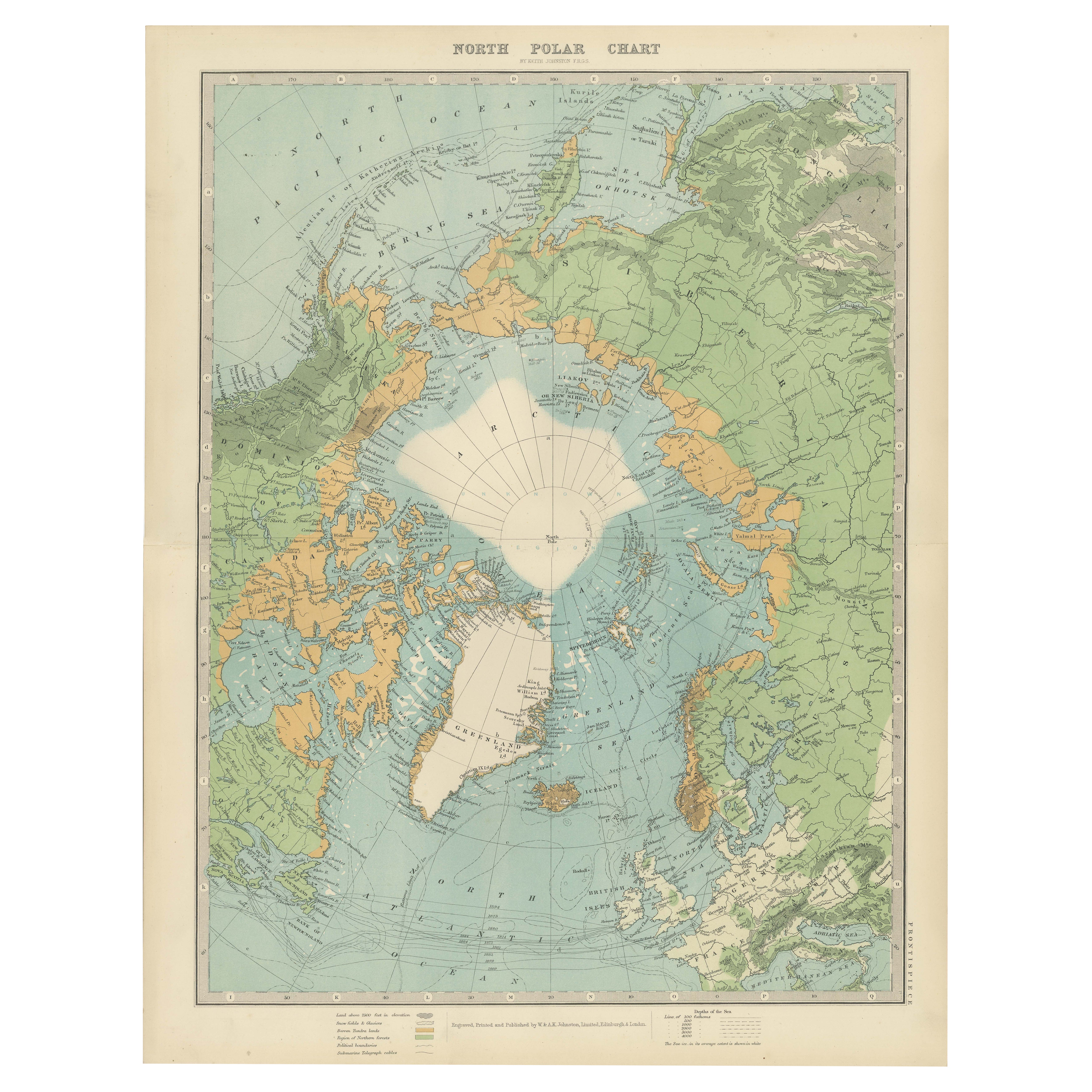
Vintage North Polar Chart – Greenland
Arctic Exploration Routes, 1903
This vintage map titled "North Polar Chart" offers a fascinating glimpse into early 20th-century Arctic e...
Category
Early 20th Century Scottish Maps
Materials
Paper
$341 Sale Price
20% Off
You May Also Like
Map of Polar Regions - Original Etching - Late 19th Century
Located in Roma, IT
This Map of Polar regions is an etching realized by an anonymous artist.
The state of preservation of the artwork is good with some small diffused stains.
Sheet dimension: 28.5 x 4...
Category
Late 19th Century Modern Figurative Prints
Materials
Etching
Original Antique Map of The Eastern Hemisphere by Dower, circa 1835
Located in St Annes, Lancashire
Nice map of the Eastern Hemisphere
Drawn and engraved by J.Dower
Published by Orr & Smith. C.1835
Unframed.
Free shipping
Category
Antique 1830s English Maps
Materials
Paper

Hemisphere Of The New Continent - Ancient Map by J.G. Heck - 1834.
By Johann Georg Heck
Located in Roma, IT
Hemisphere Of The New Continent is an artwork realized around 1760 by Johann Georg Heck
Original colored print.
Good conditions except for yellowing of paper and tears along the m...
Category
1830s Modern Figurative Prints
Materials
Etching

Large Original Vintage Map of the South Pole, circa 1920
Located in St Annes, Lancashire
Great map of the South pole.
Unframed.
Original color.
By John Bartholomew and Co. Edinburgh Geographical Institute.
Published, circa 1920.
Category
Vintage 1920s British Maps
Materials
Paper
Hemisphere Of The New Continent - Ancient Map by J.G. Heck - 1834.
By Johann Georg Heck
Located in Roma, IT
Hemisphere Of The New Continent - West is an artwork realized in 1834 by Johann Georg Heck
Original colored print.
Good conditions except for yellowing of the paper and very littl...
Category
1830s Modern Figurative Prints
Materials
Etching
Original Antique Map of The Western Hemisphere by Dower, circa 1835
Located in St Annes, Lancashire
Nice map of the Western Hemisphere
Drawn and engraved by J.Dower
Published by Orr & Smith. C.1835
Unframed.
Free shipping
Category
Antique 1830s English Maps
Materials
Paper
