Want more images or videos?
Request additional images or videos from the seller
1 of 10
Northern Italy Map – Lombardy, Venetia, Tuscany, and Sardinia 1857
Price:$366.54
$407.26List Price
About the Item
- Dimensions:Height: 14.77 in (37.5 cm)Width: 17.88 in (45.4 cm)Depth: 0.01 in (0.2 mm)
- Materials and Techniques:Paper,Engraved
- Place of Origin:
- Period:
- Date of Manufacture:1857
- Condition:Condition summary: Excellent condition with strong impression, minimal age toning, and no tears, repairs, or significant foxing. A few spots around Corsica. Colours remain vivid and paper is firm and stable.
- Seller Location:Langweer, NL
- Reference Number:Seller: BG-05552-371stDibs: LU3054345813252
About the Seller
5.0
Recognized Seller
These prestigious sellers are industry leaders and represent the highest echelon for item quality and design.
Platinum Seller
Premium sellers with a 4.7+ rating and 24-hour response times
Established in 2009
1stDibs seller since 2017
2,791 sales on 1stDibs
Authenticity Guarantee
In the unlikely event there’s an issue with an item’s authenticity, contact us within 1 year for a full refund. DetailsMoney-Back Guarantee
If your item is not as described, is damaged in transit, or does not arrive, contact us within 7 days for a full refund. Details24-Hour Cancellation
You have a 24-hour grace period in which to reconsider your purchase, with no questions asked.Vetted Professional Sellers
Our world-class sellers must adhere to strict standards for service and quality, maintaining the integrity of our listings.Price-Match Guarantee
If you find that a seller listed the same item for a lower price elsewhere, we’ll match it.Trusted Global Delivery
Our best-in-class carrier network provides specialized shipping options worldwide, including custom delivery.You May Also Like
Large Original Antique Map of Lombardy and Venice, Italy. John Dower, 1861
Located in St Annes, Lancashire
Great map of Lombardy and Venice
Lithograph engraving by John Dower
Original colour
Published, 1861
Unframed
Good condition / crease to bottom left corner
Free shipping
Category
Antique 1860s English Victorian Maps
Materials
Paper

$60
Free Shipping
H 13 in W 19 in D 0.07 in
Antique Travel Book, Baedeker’s Northern Italy, Maps, Guide, Edwardian, C.1903
Located in Hele, Devon, GB
This is an antique copy of Baedeker’s Northern Italy, a bound and illustrated travel guide book, presented in its intact, original order with only light markings commensurate with ag...
Category
Early 20th Century British Edwardian Books
Materials
Paper
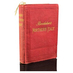
$515
H 6.3 in W 4.34 in D 1.19 in
Map of the Kingdom of Sardinia and Part of the Kingdom of Genoa, Rome
By Giovanni Maria Cassini
Located in Hamilton, Ontario
18th century map by Italian engraver Giovanni Maria Cassini (Italy 1745-1824). Map of Part of the Kingdom of Sardinia and Part of the Kingdom of Genoa: Rome. This is a hand colored a...
Category
Antique 18th Century Italian Maps
Materials
Paper

$795 Sale Price
36% Off
H 20.75 in W 25.25 in D 0.1 in
1635 Willem Blaeu Map of Northern France"Comitatvs Bellovacvm" Ric.a08
Located in Norton, MA
1635 Willem Blaeu map of northern France, entitled.
"Comitatvs Bellovacvm Vernacule Beavvais,"
Colored
Ric.a008
“COMITATVS BELLOVACVM…” Amsterdam: W...
Category
Antique 17th Century Unknown Maps
Materials
Paper

$875 / set
H 18.12 in W 22.25 in D 0.4 in
Large Original Antique Map of New York State ( Northern ), USA, C.1900
Located in St Annes, Lancashire
Fabulous map of Northern New York
Original color.
Engraved and printed by the George F. Cram Company, Indianapolis.
Published, C.1900.
Unframed.
Repairs to minor edge tears
Fr...
Category
Antique 1890s American Maps
Materials
Paper
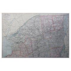
$90
Free Shipping
H 15 in W 22 in D 0.07 in
Original Antique Map of the American State of Illinois ( Northern Part ), 1903
Located in St Annes, Lancashire
Antique map of Illinois ( Northern part )
Published By A & C Black. 1903
Original colour
Good condition
Unframed.
Free shipping
Category
Antique Early 1900s English Maps
Materials
Paper

$49
Free Shipping
H 11.5 in W 16.25 in D 0.07 in
Original Antique Map of the American State of Ohio ( Northern Part ), 1903
Located in St Annes, Lancashire
Antique map of Ohio ( Northern part )
Published By A & C Black. 1903
Original colour
Good condition
Unframed.
Free shipping
Category
Antique Early 1900s English Maps
Materials
Paper

$49
Free Shipping
H 11.5 in W 16.25 in D 0.07 in
Original Antique Map of the American State of Michigan ( Northern Part ), 1903
Located in St Annes, Lancashire
Antique map of Michigan ( Northern part )
Published By A & C Black. 1903
Original colour
Good condition
Unframed.
Free shipping
Category
Antique Early 1900s English Maps
Materials
Paper

$49
Free Shipping
H 11.5 in W 16.25 in D 0.07 in
Original Antique Map of the American State of California ( Northern Part ), 1903
Located in St Annes, Lancashire
Antique map of California ( Northern part )
Published By A & C Black. 1903
Original colour
Good condition
Unframed.
Free shipping
Category
Antique Early 1900s English Maps
Materials
Paper

$49
Free Shipping
H 11.5 in W 16.25 in D 0.07 in
Original Antique Map of the American State of Missouri ( Northern part ), 1903
Located in St Annes, Lancashire
Antique map of Missouri ( Northern Part )
Published By A & C Black. 1903
Original colour
Good condition
Unframed.
Free shipping
Category
Antique Early 1900s English Maps
Materials
Paper

$49
Free Shipping
H 11.5 in W 16.25 in D 0.07 in
More From This Seller
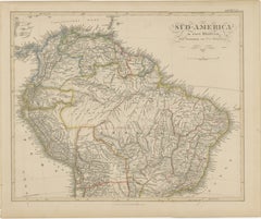
View All1857 Map of Northern South America – Brazil, Colombia, Peru by Stülpnagel
Located in Langweer, NL
1857 Map of Northern South America – Brazil, Colombia, Peru by Stülpnagel
Antique map titled “Süd-America in zwei Blättern” (South America in Two Sheets), newly edited by V. v. Stül...
Category
Antique Mid-19th Century German Maps
Materials
Paper
Antique Map of Italy, Corsica, Sardinia and Sicily, ca.1780
Located in Langweer, NL
Description: Antique map titled 'L'Italie.'
Map of Italy, Corsica, Sardinia and Sicily. Highly detailed, showing towns, rivers, some topographical features and political boundaries...
Category
Antique 1780s French Maps
Materials
Paper

$229 Sale Price
40% Off
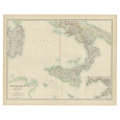
Antique Map of Southern Italy and Sardinia by Johnston, 1882
Located in Langweer, NL
"Antique map titled 'South Italy and the Island of Sardinia'. Old map of Southern Italy and the island of Sardinia. With an inset map of the Bay ...
Category
Antique 19th Century Maps
Materials
Paper
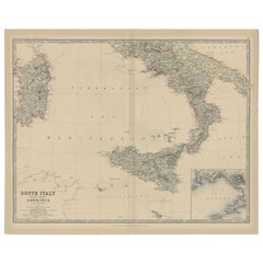
$95 Sale Price
20% Off
Antique Map of Italy, Showing Corsica, Sardinia, Croatia, Malta and More, C.1740
Located in Langweer, NL
Antique map titled 'Nieuwe Kaart van Italie na de Nieuwste waarnemingen van de l'Isle en andere.'
Attractive detailed map showing Italy as well as Corsica, Sardinia, Minorca, Croat...
Category
Antique 18th Century Maps
Materials
Paper

Antique Map of South Italy and the Island of Sardinia by Johnston (1909)
Located in Langweer, NL
Antique map titled 'South Italy and the Island of Sardinia'. Original antique map of South Italy and the Island of Sardinia. With inset map of Naples. Th...
Category
Early 20th Century Maps
Materials
Paper
$239 Sale Price
20% Off
Antique Map of Northern Italy by Cluver, 1685
Located in Langweer, NL
Antique map titled 'Histri, Carni, Veneti item Rhaetiae Pars.' Charming miniature map of northern Italy with the Adriatic or upper sea, now called the Gulf of Venice, from the pocket...
Category
Antique 17th Century Maps
Materials
Paper
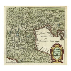
$191 Sale Price
20% Off
Still Thinking About These?
All Recently ViewedMore Ways To Browse
House Of Savoy
Beni Ourain Rugs
Glass Top Wood Base Coffee Tables
T Chair
Pair Of Danish Chairs
Veneer Dining Tables
1970 Italian Armchair
Furniture Uk
House Of Denmark Table And Chairs
Louis Marble Top Side Table
Antique Russian Rugs
Baker Furniture By
For Kids
Sterling Silver Flatware Set Service For 12
Tufted Bar
Pair Of French Antique Armchairs
1970s Brass Glass Coffee Table
Antique Column Base