Items Similar to Old Decorative
Highly Detailed Sea Chart of the North Dutch-German Coast, 1681
Want more images or videos?
Request additional images or videos from the seller
1 of 10
Old Decorative
Highly Detailed Sea Chart of the North Dutch-German Coast, 1681
$1,370.47
$1,957.8230% Off
£1,023.12
£1,461.6130% Off
€1,155
€1,65030% Off
CA$1,904
CA$2,72030% Off
A$2,048.03
A$2,925.7530% Off
CHF 1,094.52
CHF 1,563.6130% Off
MX$24,140.39
MX$34,486.2730% Off
NOK 13,799.39
NOK 19,713.4130% Off
SEK 12,615.26
SEK 18,021.8030% Off
DKK 8,802.40
DKK 12,574.8530% Off
About the Item
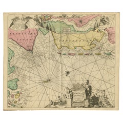
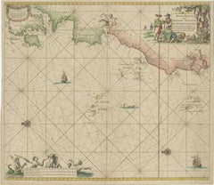
Antique map titled 'Paskaart van een gedeelte van Vriesland, Groeninger, en Emderland. Met zyn onderhoorige Eylanden; Strekkende van't Eylant der Schelling'.
Decorative and highly detailed sea chart of part of the Dutch Coast, centered on Emden, the mouth of the river Ems and some offshore islands Wangerode, Nordernei, Borkum, Ameland, Schiermonnikoog. Van Keulen's fine chart locates anchorages, shoals, soundings and nany other deails and place names mostly along the coast of the North Sea. Includes a striking cartouche and other embellishment.
Artists and Engravers: Johannes van Keulen (1654, Deventer - 1715, Amsterdam) was a 17th-century Dutch cartographer. He published the influential nautical atlas the Zee-Atlas and the pilot guide Zee-Fakkel (meaning Sea-Torch in English).
Condition: Fair. Minor soiling. Several repairs, mainly at the bottom. Small tear in the middle. Please study image carefully.
- Dimensions:Height: 21.38 in (54.3 cm)Width: 23.82 in (60.5 cm)Depth: 0 in (0.02 mm)
- Materials and Techniques:
- Place of Origin:
- Period:1680-1689
- Date of Manufacture:1681
- Condition:Repaired: Several repairs, mainly at the bottom. Wear consistent with age and use. Condition: Fair. Minor soiling. Several repairs, mainly at the bottom. Small tear in the middle. Please study image carefully.
- Seller Location:Langweer, NL
- Reference Number:Seller: BG-049181stDibs: LU3054326715522
About the Seller
5.0
Recognized Seller
These prestigious sellers are industry leaders and represent the highest echelon for item quality and design.
Platinum Seller
Premium sellers with a 4.7+ rating and 24-hour response times
Established in 2009
1stDibs seller since 2017
2,836 sales on 1stDibs
Typical response time: 1 hour
- ShippingRetrieving quote...Shipping from: Langweer, Netherlands
- Return Policy
More From This Seller
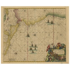
View AllRare Sea Chart of the East Frisian Islands or Watten and the North Sea, c.1700
Located in Langweer, NL
Description: Antique map titled 'Paskaarte van de rievier de Elve streckende van Oldenbroek tot Hamburgh.'
Rare and interesting chart of the East Frisian Islands (or Watten) and th...
Category
Antique Early 1700s Dutch Maps
Materials
Paper
$1,536 Sale Price
30% Off
Original Antique Sea Chart of the Maas
or Meuse
River with Neptunes, 1684
Located in Langweer, NL
Antique map titled 'Paskaerte van het inkoomen van de Maes (..)'.
Original antique sea chart of the Maas (or Meuse) river and part of the Dutch coa...
Category
Antique 1680s Dutch Maps
Materials
Paper

$645 Sale Price
27% Off
Sea Chart of Central America and the Northwest Coast of South America, ca.1745
Located in Langweer, NL
Antique map titled 'Novae Hispaniae, Chili, Peruviae et Guatamala Littorae.'
Sea chart of Central America and the northwest coast of South America, oriented to the east, by Reinier & Joshua Ottens (after Frederick de Wit - 1675) in 1745 ('Atlas van de Zeevaart'). The map shows all or parts of the coasts of Peru, Chili, Honduras, Costa Rica and Mexico as well as the western Caribbean and the Galapagos...
Category
Antique 1740s Maps
Materials
Paper
$2,325 Sale Price
20% Off
Free Shipping
1717 Johannes Van Keulen Sea Chart of the Eastern Atlantic - Amsterdam to Gambia
Located in Langweer, NL
1717 Johannes Van Keulen Sea Chart of the Eastern Atlantic - Amsterdam to Gambia
This 1717 sea chart by Johannes Van Keulen, titled "Nieuwe Paskaert vande ...
Category
Antique 1710s Dutch Maps
Materials
Paper
$2,002 Sale Price
25% Off
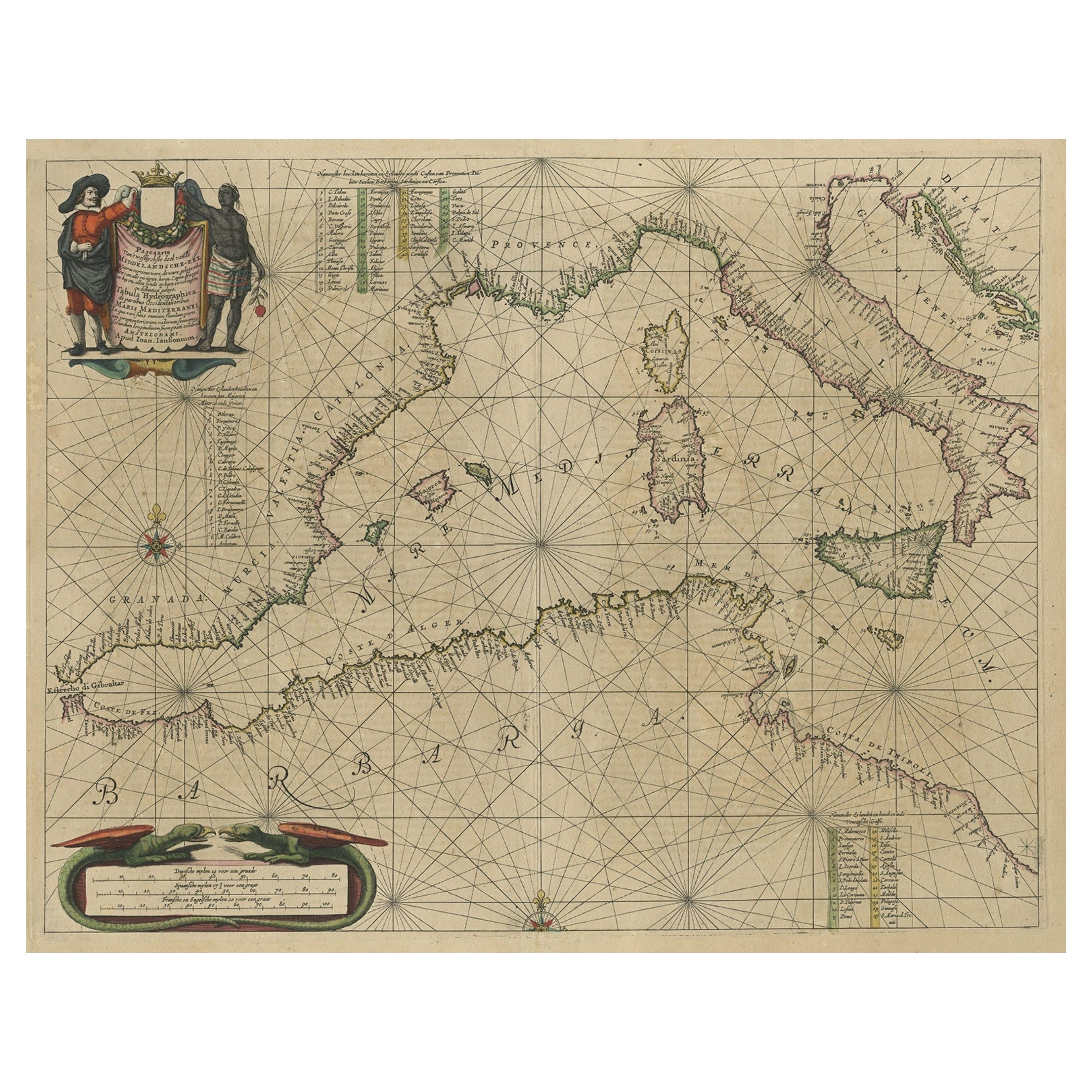
Original Antique Engraving of a Sea Chart of the Western Mediterranean, ca.1650
Located in Langweer, NL
Antique map titled 'Pascaerte van 't westlyckste deel vande Middelandsche-Zee (..)'.
Sea chart of the Western Mediterranean. The map extends from the Straits of Gibralter to Italy ...
Category
Antique 1650s Maps
Materials
Paper

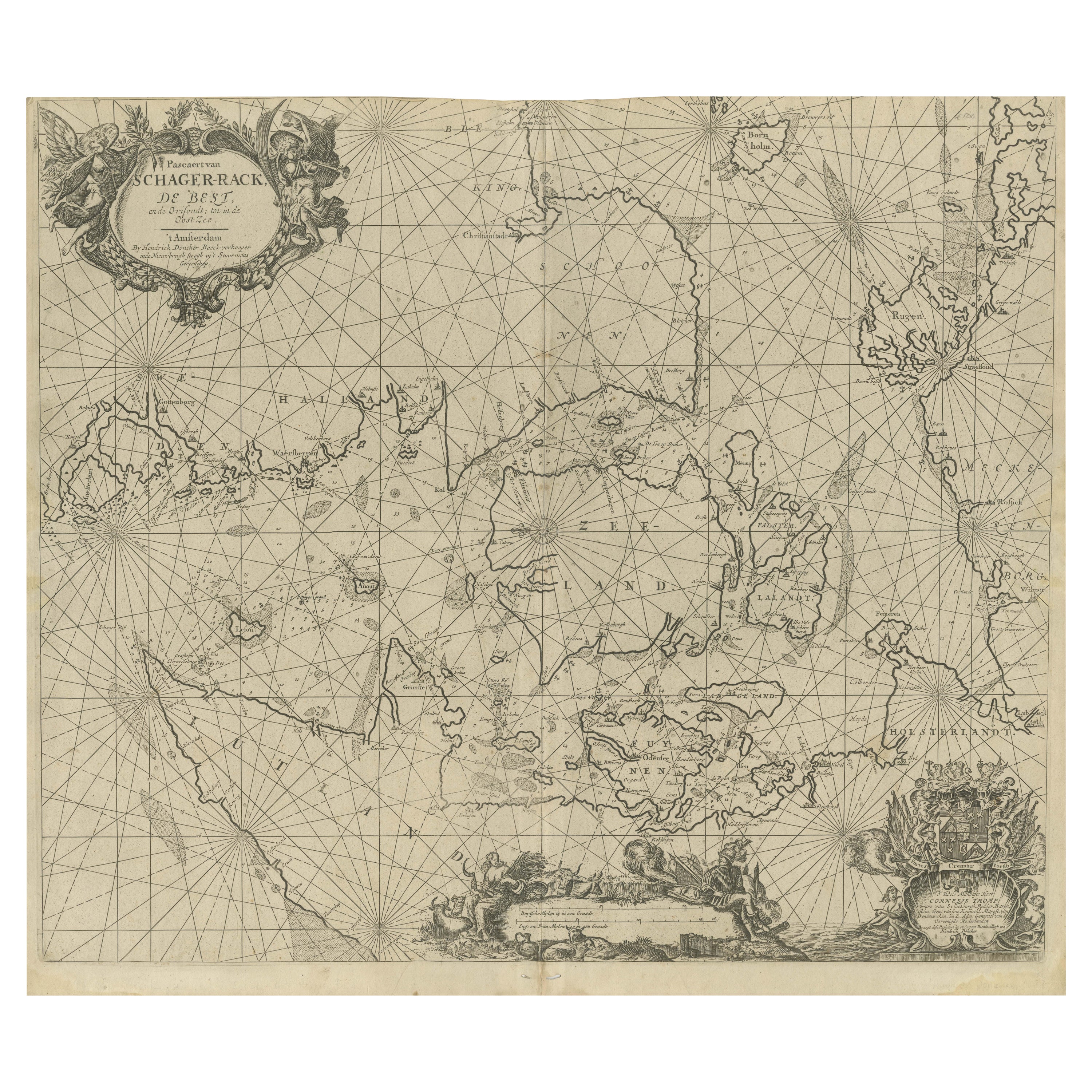
Nautical Chart of Skagerrak and Øresund by Johannes van Keulen, 1680
Located in Langweer, NL
This map titled *Pascaret van Schager-Rack de Bælt en de Sondt* was created by the prominent Dutch cartographer Johannes van Keulen and published in Amsterd...
Category
Antique Late 17th Century Dutch Maps
Materials
Paper
$911 Sale Price
20% Off
You May Also Like
Flanders, Holland
Norfolk: Hand-Colored 17th Century Sea Chart by Collins
By Captain Greenvile Collins
Located in Alamo, CA
This hand-colored chart of the seas about Flanders, Holland, Frisia, and Norfolk is from "Great Britain's Coasting Pilot. Being a New and Exact Survey of the Sea-Coast of England" by...
Category
Antique Late 17th Century English Maps
Materials
Paper

Plymouth, England: A Hand-Colored 17th Century Sea Chart by Captain Collins
By Captain Greenvile Collins
Located in Alamo, CA
This hand-colored sea chart of the area around Plymouth, England from "Great Britain's Coasting Pilot. Being a New and Exact Survey of the Sea-Coast of England", first published in 1...
Category
Antique Late 17th Century English Maps
Materials
Paper

Antique Map - Mare Pacificum - Etching by Johannes Janssonius - 1650s
By Johannes Janssonius
Located in Roma, IT
Mare Pacificum is an antique map realized in 1650 by Johannes Janssonius (1588-1664).
The Map is Hand-colored etching, with coeval watercolorang.
Good conditions with slight foxing...
Category
1650s Modern Figurative Prints
Materials
Etching

Rugen Island, Germany: An Early 17th Century Map by Mercator and Hondius
By Gerard Mercator
Located in Alamo, CA
This is an early 17th century map entitled "Nova Famigerabilis Insulae Ac Ducatus Rugiae Desciptio" (Map of Rugen Island, Germany) by Gerard Mercator and Henricus and Joducus Hondiu...
Category
Early 17th Century Old Masters Landscape Prints
Materials
Engraving

Antique Map - Gallia - Etching by Johannes Janssonius - 1650s
By Johannes Janssonius
Located in Roma, IT
Antique Map - Gallia is an antique map realized in 1650 by Johannes Janssonius (1588-1664).
The Map is Hand-colored etching, with coeval watercoloring.
Good conditions with slight ...
Category
1650s Modern Figurative Prints
Materials
Etching

Rare Original Map of New Amsterdam (New York) – “Restitutio”, ca. 1674 –
Located in Dronten, NL
An exceptionally rare and original 17th-century engraving of New Amsterdam, now New York City, published by the renowned Amsterdam cartographer Carel (Carolus) Allard around 1674. Kn...
Category
Antique 17th Century Dutch Maps
Materials
Paper

More Ways To Browse
English Fairing
Persian Maps
Afghanistan Antique Map
Antique Furniture Delaware
Antique Furniture Wisconsin
Antique Map By Coronelli
Antique Map Iceland
Cyprus Antique Maps
John Speed Maps
M Howard
Used Office Furniture Michigan
Antique Geological Maps
Antique Manitoba
Australian Colonial
Bengal Map
Stanford Furniture
Tennessee Antique Furniture
Used Furniture Alabama