Want more images or videos?
Request additional images or videos from the seller
1 of 6
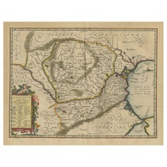
Old Decorative Map of Austria, Centered on the Danube River and Vienna, Ca.1720
$265.19List Price
About the Item
- Dimensions:Height: 20.87 in (53 cm)Width: 24.02 in (61 cm)Depth: 0 in (0.02 mm)
- Materials and Techniques:
- Period:1720-1729
- Date of Manufacture:circa 1720
- Condition:Repaired: repaired tears in the margins,. Wear consistent with age and use. Condition: Fair. Several imperfections such as creases, staining, slight paper loss left and bottom right margin; backed. Original middle fold as issued. General age-related toning and/or occasional minor defects.
- Seller Location:Langweer, NL
- Reference Number:Seller: PC-58079 1stDibs: LU3054327309372
About the Seller
5.0
Recognized Seller
These prestigious sellers are industry leaders and represent the highest echelon for item quality and design.
Platinum Seller
Premium sellers with a 4.7+ rating and 24-hour response times
Established in 2009
1stDibs seller since 2017
2,836 sales on 1stDibs
Typical response time: 1 hour
Authenticity Guarantee
In the unlikely event there’s an issue with an item’s authenticity, contact us within 1 year for a full refund. DetailsMoney-Back Guarantee
If your item is not as described, is damaged in transit, or does not arrive, contact us within 7 days for a full refund. Details24-Hour Cancellation
You have a 24-hour grace period in which to reconsider your purchase, with no questions asked.Vetted Professional Sellers
Our world-class sellers must adhere to strict standards for service and quality, maintaining the integrity of our listings.Price-Match Guarantee
If you find that a seller listed the same item for a lower price elsewhere, we’ll match it.Trusted Global Delivery
Our best-in-class carrier network provides specialized shipping options worldwide, including custom delivery.You May Also Like
Hand Colored 18th Century Homann Map of Austria Including Vienna and the Danube
By Johann Baptist Homann
Located in Alamo, CA
"Archiducatus Austriae inferioris" is a hand colored map of Austria created by Johann Baptist Homann (1663-1724) and published in Nuremberg, Germany in 1728 shortly after his death. ...
Category
Antique Early 18th Century German Maps
Materials
Paper

$675
H 20.25 in W 23.63 in D 0.07 in
Vienna, Austria: A Large 17th Century Hand-Colored Map by Sanson and Jaillot
By Nicolas Sanson
Located in Alamo, CA
This large 17th century hand-colored map of Vienna, Austria and the surrounding countryside and villages entitled "Plan de la Ville de Vienne en Austrich...
Category
Antique 1690s French Maps
Materials
Paper

$2,175
H 20 in W 24.88 in D 0.13 in
Hand-Colored 18th Century Homann Map of the Danube, Italy, Greece, Croatia
By Johann Baptist Homann
Located in Alamo, CA
"Fluviorum in Europa principis Danubii" is a hand colored map of the region about the Danube river created by Johann Baptist Homann (1663-1724) in his 'Atlas Novus Terrarum', publish...
Category
Antique Early 18th Century German Maps
Materials
Paper

$875
H 20 in W 23.88 in D 0.07 in
Vintage "View of the Center of Paris Taken from the Air" Lithograph Map
Located in San Diego, CA
A very stylish "View of the Center of Paris Taken from the Air" lithograph map published by the Paris Ministry of Tourism, circa early 1950s. The piece measures 27" x 43" and shows...
Category
20th Century French Mid-Century Modern Prints
Materials
Paper

$680 Sale Price
20% Off
H 43 in W 27 in D 0.25 in
Old Horizontal Map of England
By Tasso
Located in Alessandria, Piemonte
ST/520 - Old rare Italian map of England, dated 1826-1827 - by Girolamo Tasso, editor in Venise, for the atlas of M.r Le-Sage.
Category
Antique Early 19th Century Italian Other Prints
Materials
Paper

Map of the Republic of Genoa
Located in New York, NY
Framed antique hand-coloured map of the Republic of Genoa including the duchies of Mantua, Modena, and Parma.
Europe, late 18th century.
Dimension: 25...
Category
Antique Late 18th Century European Maps

Map "Estuary- Mouth of the Thames"
Located in Alessandria, Piemonte
ST/426 - Antique French Map of the estuary of the Thames, map dated 1769 -
"Mape of the entrance of the Thames. Designed by filing of Navy cards fo...
Category
Antique Mid-18th Century French Other Prints
Materials
Paper

The Normandy Region of France: A 17th C. Hand-colored Map by Sanson and Jaillot
By Nicolas Sanson
Located in Alamo, CA
This large hand-colored map entitled "Le Duché et Gouvernement de Normandie divisée en Haute et Basse Normandie en divers Pays; et par evêchez, avec le Gouvernement General du Havre ...
Category
Antique 1690s French Maps
Materials
Paper

$2,375
H 24.88 in W 38 in D 0.13 in
New Map of North America from the Latest Discoveries, 1763
Located in Philadelphia, PA
A fine antique 18th century map of the North American seaboard.
Entitled "A New Map of North America from the Latest Discoveries 1763".
By the Cartographer/Engraver - John Spil...
Category
Antique Mid-18th Century English Georgian Maps
Materials
Paper

Original Antique Map of The World by Thomas Clerk, 1817
Located in St Annes, Lancashire
Great map of The Eastern and Western Hemispheres
On 2 sheets
Copper-plate engraving
Drawn and engraved by Thomas Clerk, Edinburgh.
Published by Mackenzie And Dent, 1817
...
Category
Antique 1810s English Maps
Materials
Paper

$90 / set
Free Shipping
H 10.25 in W 8.25 in D 0.07 in
More From This Seller
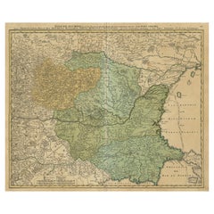
View AllAntique Map of Romania and Bulgaria Centered on the Danube River
Located in Langweer, NL
Antique map titled 'Vetus descriptio Daciarum nec non Moesiarum'. Impressive map of the area of Romania and Bulgaria centered on the Danube River. The map is based on Ortelius' map o...
Category
Antique Mid-17th Century Maps
Materials
Paper
$653 Sale Price
20% Off
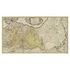
Antique Map of Austria, Centered Around the Danube from Passau to Vienna, C.1690
Located in Langweer, NL
Antique map of Austria titled 'Circuli Austriaci pars septentrionalis in quia archiducatus Austriae et Ducatus Stiriae accuratissime divisi ostenduntur per F. de Wit'.
Detailed m...
Category
Antique 1690s Maps
Materials
Paper
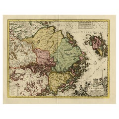
Original and Decorative Antique Engraved Map of Finland and Sweden, ca.1720
Located in Langweer, NL
Antique map titled 'Ducatus Uplandiae cum Westmanniae Sudermanniae (..)'
This map shows parts of Finland and Sweden. Originally published by Frederick de Wit in the late 1600's. ...
Category
Antique 1720s Maps
Materials
Paper
$1,373 Sale Price
20% Off
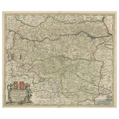
Danube River Incl Serbia, Moldavia, Transylvania, Romania, Bulgaria Etc, ca.1720
Located in Langweer, NL
Antique map titled 'Danubii Fluminis (..)'.
Regional map of the Donau river, Shows the Danube river from Belgrade in Serbia, along the border between ...
Category
Antique 1720s Maps
Materials
Paper
$876 Sale Price
20% Off
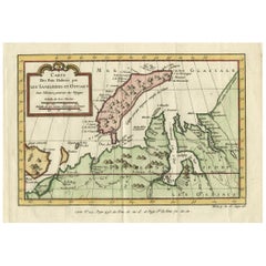
Decorative Original Old Map of Nova Zembla and the Russian Mainland, ca.1760
Located in Langweer, NL
Antique map titled 'Carte Des Pais Habites par les Samojedes et Ostiacs.'
Map of Novaya Zemlya and the Russian mainland. Source unknown, to be determined.
Artists and Engraver...
Category
Antique 1760s Maps
Materials
Paper
Original Antique Map of the Province of Utrecht, the Netherlands, ca.1720
Located in Langweer, NL
Antique map titled ‘Tabula Nova Provinciae Ultrajectinae (..)’.
Original antique map of the province of Utrecht, the Netherlands. It shows the region of Amsterdam, Utrecht, Gouda, ...
Category
Antique 1720s Maps
Materials
Paper
Still Thinking About These?
All Recently ViewedMore Ways To Browse
On The Danube
Map Of Vienna
Antique Coal Mining
Antique Dutch Bible
Antique Louisiana Map
Antique Maps Of Sicily
Iran Map
Map Of Great Britain
Sardinia Map
Antique Map Of Thailand
Antique Wooden Roller
Croatia Map
Kentucky Antique Furniture
Louisiana Antique Furniture
Map Of Ancient Greece
Map Of Native American Tribes
Old Spice
Romania Map