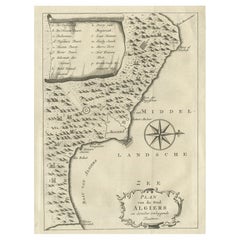
Items Similar to Old Dutch Map of the City of Oran
Warran
, Algeria, 1773


Want more images or videos?
Request additional images or videos from the seller
1 of 5
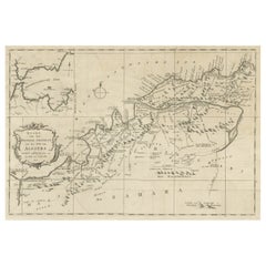
Old Dutch Map of the City of Oran
Warran
, Algeria, 1773
$347.99
£257.88
€290
CA$475.60
A$517.73
CHF 274.81
MX$6,229.36
NOK 3,482.21
SEK 3,190.69
DKK 2,209.02
About the Item
Antique print titled 'Ligging der Stad en Haven van Warran of Oran'.
Old map of the city of Oran (Warran), Algeria. Originates from the first Dutch editon of an interesting travel account of Northern Africa titled 'Reizen en Aanmerkingen door en over Barbaryen en het Ooste'.
Artists and Engravers: Author: T. Shaw. Translated by P. Boddaert and published by J. van Schoonhoven.
Condition:
Very good, general age-related toning. Please study image carefully.
- Dimensions:Height: 10.24 in (26 cm)Width: 8.27 in (21 cm)Depth: 0 in (0.02 mm)
- Materials and Techniques:
- Period:1770-1779
- Date of Manufacture:1773
- Condition:Wear consistent with age and use.
- Seller Location:Langweer, NL
- Reference Number:Seller: BG-11797-4 1stDibs: LU3054326777192
About the Seller
5.0
Recognized Seller
These prestigious sellers are industry leaders and represent the highest echelon for item quality and design.
Platinum Seller
Premium sellers with a 4.7+ rating and 24-hour response times
Established in 2009
1stDibs seller since 2017
2,816 sales on 1stDibs
Typical response time: 1 hour
- ShippingRetrieving quote...Shipping from: Langweer, Netherlands
- Return Policy
More From This Seller
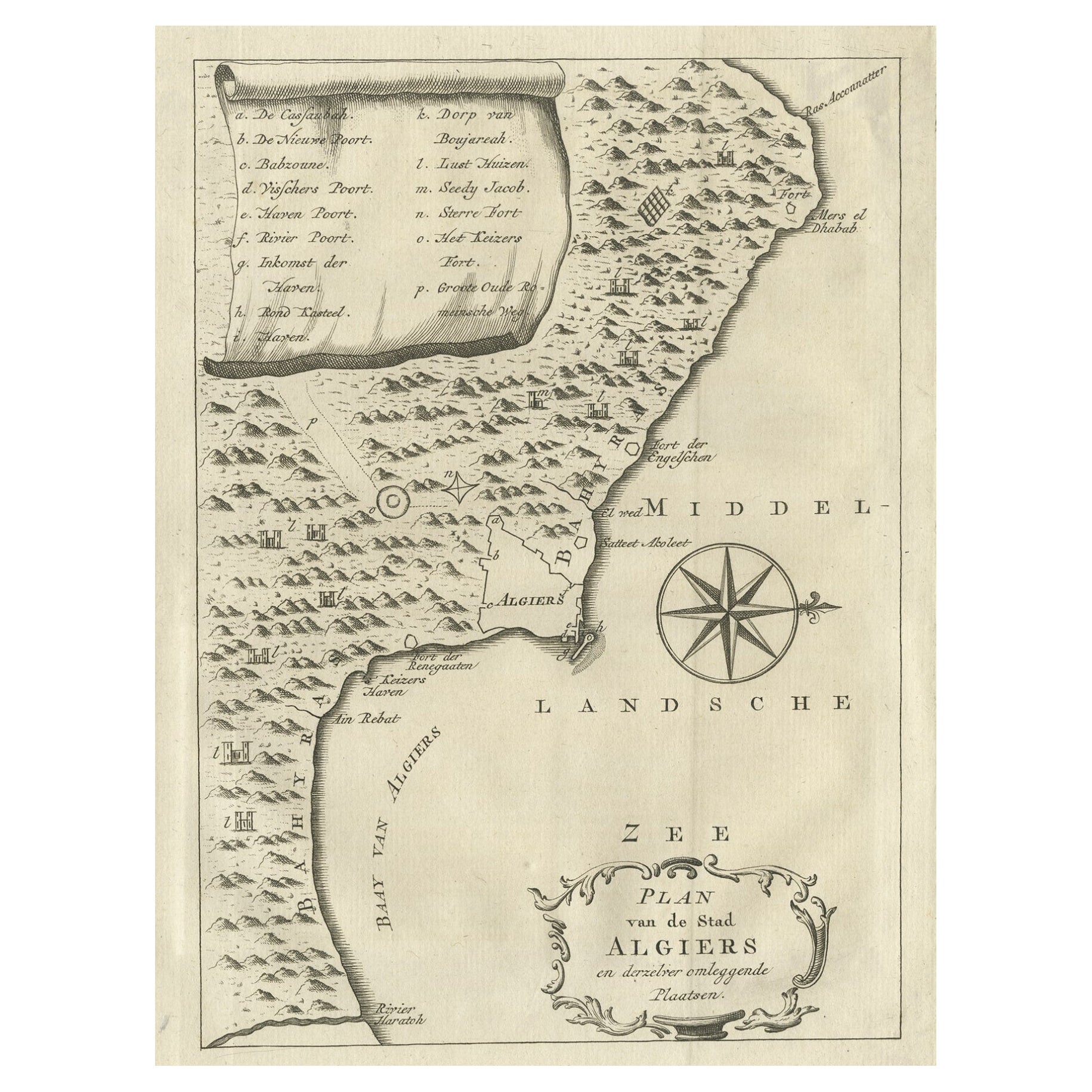
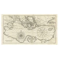
View AllOld Map of Algiers, with Surrounding Cities and the Bay of Algiers, 1773
Located in Langweer, NL
Antique print titled 'Plan van de Stad Algiers'.
Old map of Algiers, also depicting surrounding cities and the Bay of Algiers. Originates from the first Dutch editon of an interest...
Category
Antique 1770s Maps
Materials
Paper
Original Antique Map of Northern Africa by Van Dùren (1749)
Located in Langweer, NL
This is a German antique map titled 'Neue Geographische Vorstellung der Mitternaechtlichen Küste von Africa'. Original antique engraving of Northern Africa extending from the Strait ...
Category
Antique Mid-18th Century Maps
Materials
Paper

$335 Sale Price
20% Off
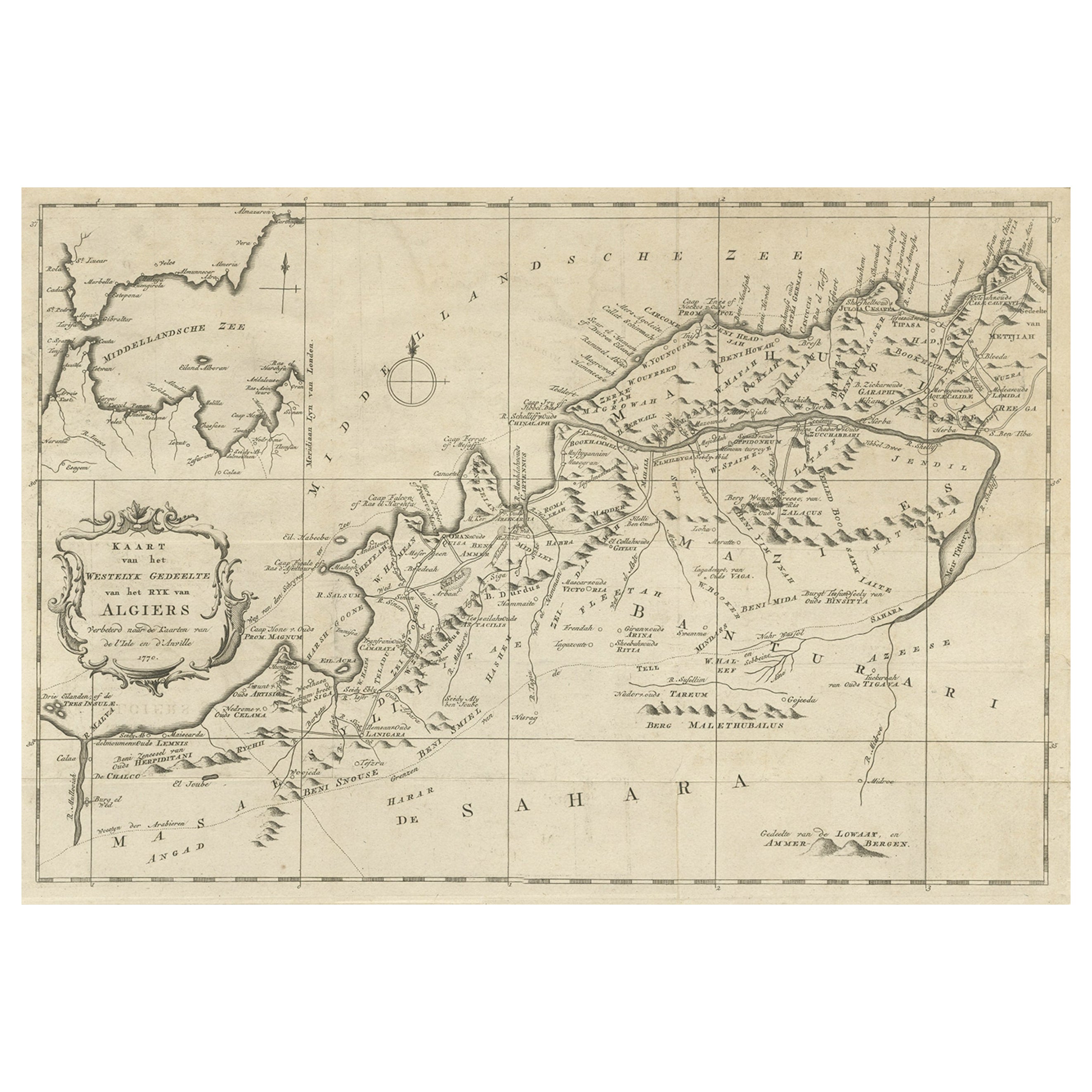
Old Map of the Western Region of the Kingdom of Algiers, Algeria, 1773
Located in Langweer, NL
Antique map titled 'Kaart van het Westelyk Gedeelte van het Ryk van Algiers'.
Old map of the western region of the Kingdom of Algiers, Algeria. Originates from the first Dutch ed...
Category
Antique 1770s Maps
Materials
Paper
$364 Sale Price
20% Off
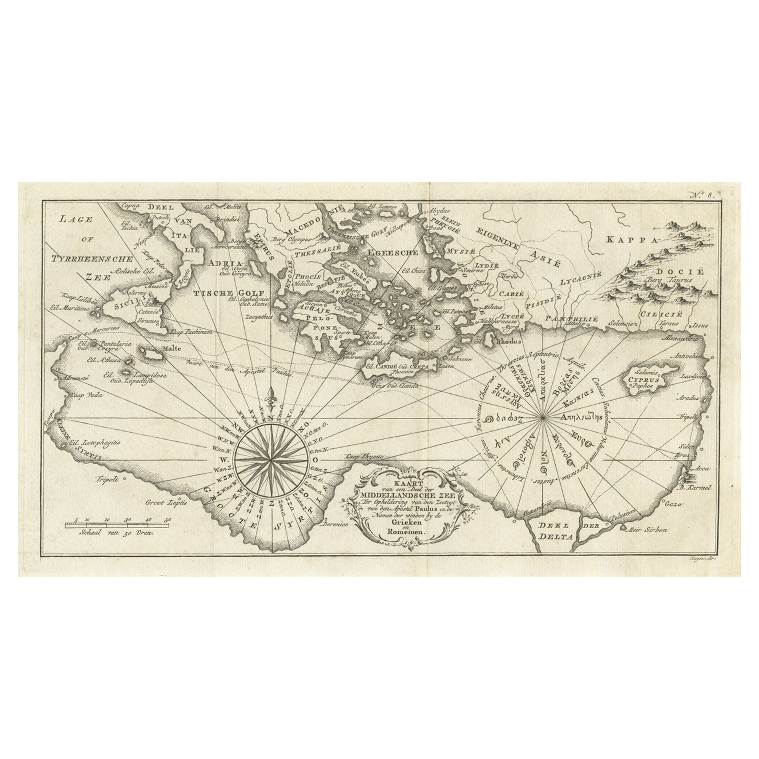
Old Dutch Map of the Region Around the Mediterranean Sea, 1773
Located in Langweer, NL
Antique map titled 'Kaart van een Deel der Middelandsche Zee (..)'.
Old map of the region around the Mediterranean Sea. Originates from the first Dutch editon of an interesting t...
Category
Antique 1770s Maps
Materials
Paper
$345 Sale Price
20% Off
Rare Antique Map of
Barbarie
or Northern Africa, 1655
Located in Langweer, NL
Antique map titled 'Partie de la Coste de Barbarie en Africque ou sont les Royaumes de Tunis et Tripoli et Pays Circomvoisins'. This map depicts North Africa with Malta and originate...
Category
Antique 17th Century Maps
Materials
Paper

Antique Map of a Bay on the Coast of Chile, South America, c.1749
Located in Langweer, NL
Antique map titled 'Plan van een Baai en Haven aan de Kust van Chili (..) - Plan d'une Baye de la Côte du Chili (..)'. Original antique map of a bay on the coast of Chile discovered ...
Category
Antique 18th Century Maps
Materials
Paper

You May Also Like
West Coast of Africa, Guinea
Sierra Leone: An 18th Century Map by Bellin
By Jacques-Nicolas Bellin
Located in Alamo, CA
Jacques Bellin's copper-plate map entitled "Partie de la Coste de Guinee Dupuis la Riviere de Sierra Leona Jusquau Cap das Palmas", depicting the coast of Guinea and Sierra Leone in ...
Category
Antique Mid-18th Century French Maps
Materials
Paper

$460 Sale Price
20% Off
1627 Hendrik Hondius Map Entitled "Vltoniae Orientalis Pars, " Ric.a009
Located in Norton, MA
1627 Hendrik Hondius map entitled
"Vltoniae orientalis pars,"
Ric.a009
Title:
Vltoniae orientalis : pars
Title (alt.) :
Ultoniae orientalis pars
Creator:
Mercator, Gerh...
Category
Antique 17th Century Dutch Maps
Materials
Paper

"Nova Barbariae Descriptio", a 17th Century Hand-Colored Map of North Africa
By Johannes Janssonius
Located in Alamo, CA
This original attractive 17th century hand-colored map of North Africa entitled "Nova Barbariae Descriptio" by Johannes Janssonius was published in Paris in 1635. It includes the Med...
Category
Antique Mid-17th Century Dutch Maps
Materials
Paper

$1,020 Sale Price
20% Off
1646 Jansson Map Entitled "Procinvia Connactiae, " Ric.a006
Located in Norton, MA
1646 Jansson map entitled
"Procinvia connactiae,"
Ric.a006
Description: The PROVINCE of CONNAVGT 490 x 380From vol 4 of Jansson's Atlas Novus 1646, published in Amsterdam with...
Category
Antique 17th Century Unknown Maps
Materials
Paper

1640 Willem Blaeu Map Entitled "Contado di molise et principato vltra, " Ric.a003
By Willem Blaeu
Located in Norton, MA
1640 Willem Blaeu map entitled
"Contado di molise et principato vltra,"
Colored
Ric. a003
Measures: 38 x 49.6 cm and wide margins
DBLAEU.
Cou...
Category
Antique 17th Century Dutch Maps
Materials
Paper

1654 Joan Blaeu Map the Sutherland, Scotland, Entitled "Southerlandia, "Ric0007
Located in Norton, MA
1654 Joan Blaeu map of the
Sutherland, Scotland, entitled
"Southerlandia,"
Hand Colored
Ric0007
Description:
Lovely map centered on Sedan and D...
Category
Antique 17th Century Dutch Maps
Materials
Paper

More Ways To Browse
Dutch City
Africa Door
Antique Map By Coronelli
Cyprus Antique Maps
John Speed Maps
M Howard
Used Office Furniture Michigan
Antique Geological Maps
Antique Manitoba
Australian Colonial
Bengal Map
Stanford Furniture
Tennessee Antique Furniture
Used Furniture Alabama
Used Office Furniture Maine
Ancient World Map
Antique Florida Map
Antique Map Chile