Items Similar to Old Dutch Map of Part of Syria and Phoenicia, 1773


Want more images or videos?
Request additional images or videos from the seller
1 of 5
Old Dutch Map of Part of Syria and Phoenicia, 1773
$382.96
£286.68
€320
CA$527.19
A$576.32
CHF 304.90
MX$6,896.57
NOK 3,879.39
SEK 3,551.19
DKK 2,438.01
About the Item
Antique print titled 'Gedeelte van Syriën en Phenicië'.
Old map of part of Syria and Phoenicia. Originates from the first Dutch editon of an interesting travel account of Northern Africa titled 'Reizen en Aanmerkingen door en over Barbaryen en het Ooste'.
Artists and Engravers: Author: T. Shaw. Translated by P. Boddaert and published by J. van Schoonhoven.
Condition:
Very good, general age-related toning. Please study image carefully.
- Dimensions:Height: 10.44 in (26.5 cm)Width: 7.88 in (20 cm)Depth: 0 in (0.02 mm)
- Materials and Techniques:
- Period:1770-1779
- Date of Manufacture:1773
- Condition:
- Seller Location:Langweer, NL
- Reference Number:Seller: BG-11797-16 1stDibs: LU3054326777142
About the Seller
5.0
Recognized Seller
These prestigious sellers are industry leaders and represent the highest echelon for item quality and design.
Platinum Seller
Premium sellers with a 4.7+ rating and 24-hour response times
Established in 2009
1stDibs seller since 2017
2,793 sales on 1stDibs
Typical response time: <1 hour
- ShippingRetrieving quote...Shipping from: Langweer, Netherlands
- Return Policy
More From This Seller
View AllOriginal Antique Map of Syria Phoenice by Van Dùren
1749
Located in Langweer, NL
Interesting Antique map published in Germany titled 'Neue Vorstellung von Phoenice und Syrien (..)' This map is engraved with a lot of details. It is an original antique map of Syria...
Category
Antique Mid-18th Century Maps
Materials
Paper

$287 Sale Price
20% Off
Antique Map of the Holy Land by Van Luchtenburg, c.1720
Located in Langweer, NL
Antique map titled 'Heylige Land verdeeld in de Twaalf Stammen Israels (..).' Highly detailed map of the Holy Land divided into 12 tribes of Israel...
Category
Antique 18th Century Maps
Materials
Paper

Antique Map of Eastern Mediterranean and Asia Minor by a Benedictine, c.1725
Located in Langweer, NL
Antique map titled 'Byzondere Afbeelding der Landschappen, van de Apostelen bevaren en doorwandelt om het Evangelium J. C. te Prediken.' Map of the lands travelled by the Apostles to...
Category
Antique 18th Century French Maps
Materials
Paper

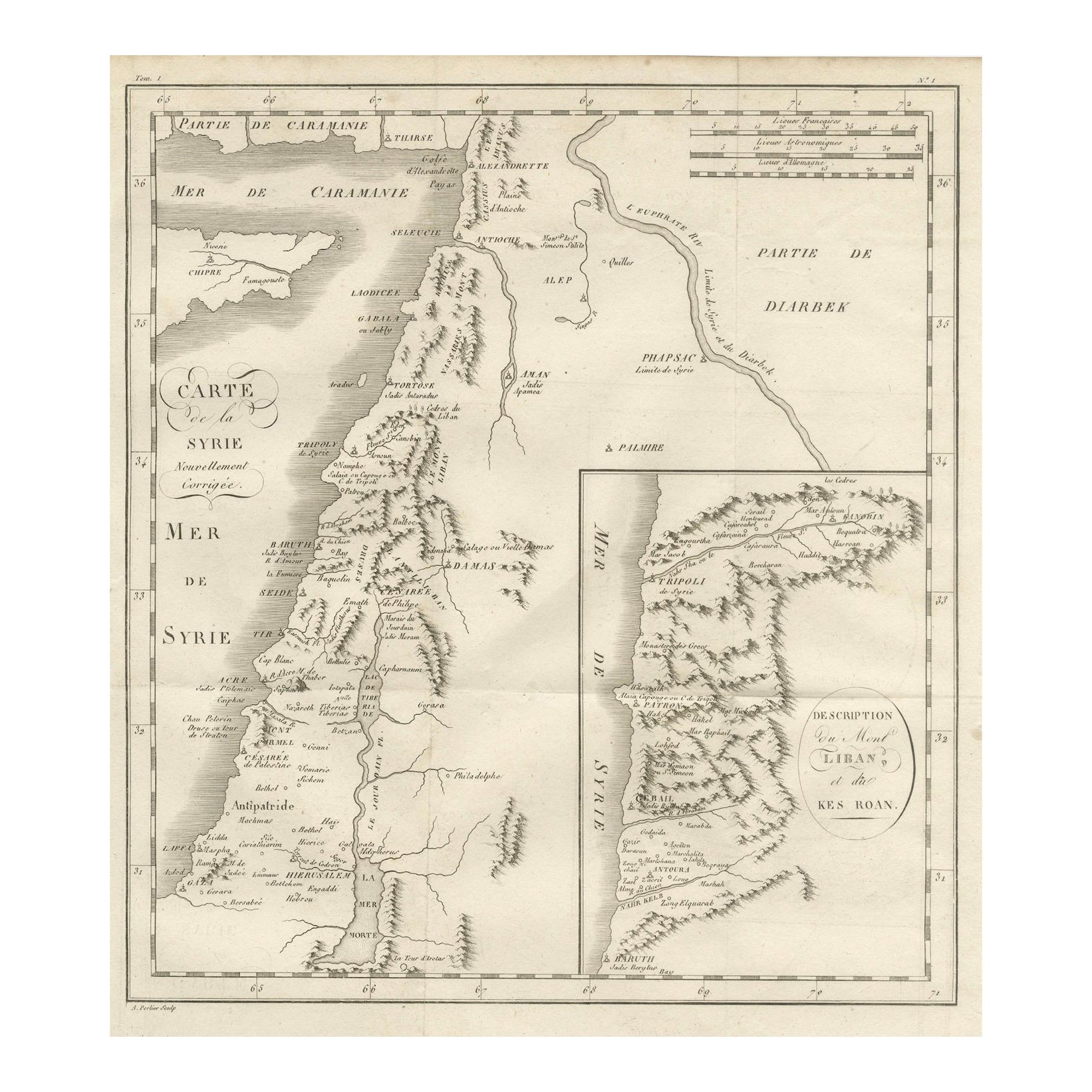
Antique Map of Syria, Mount Lebanon and Palestine – circa 1760
Located in Langweer, NL
Map of Syria and Mount Lebanon – “Carte de la Syrie”, c.1760
This finely engraved 18th-century map, titled Carte de la Syrie nouvellement corrigée, presents the region of Syria and ...
Category
Antique Mid-18th Century French Maps
Materials
Paper
Antique Map Eastern Mediterranean by D. Stoopendaal
circa 1710
Located in Langweer, NL
Antique map Middle East titled 'De Beschryving van de Reysen Pauli en van de Andere Apostelen'. Antique map of the Eastern Mediterranean with details of the travels by Apostle Paul...
Category
Antique Early 18th Century Dutch Maps
Materials
Paper

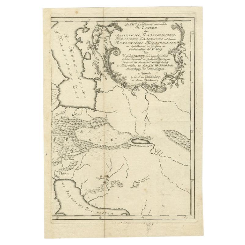
Ancient Persia, Assyria and Babylon – Willem Albert Bachiene, c.1760
Located in Langweer, NL
Ancient Persia, Assyria and Babylon – Willem Albert Bachiene, circa 1760
Antique map depicting the territories of the Assyrian, Babylonian, Persian, Gr...
Category
Antique 18th Century Dutch Maps
Materials
Paper
You May Also Like
Original Antique Map of Ancient Greece, Achaia, Corinth, 1786
Located in St Annes, Lancashire
Great map of Ancient Greece. Showing the region of Thessaly, including Mount Olympus
Drawn by J.D. Barbie Du Bocage
Copper plate engraving by P.F Tardieu
Original hand color...
Category
Antique 1780s French Other Maps
Materials
Paper

Circa 1825 original engraving of the map of Syria by Giraldon Bovinet
Located in PARIS, FR
The circa 1825 original engraving of "Syrie" by Giraldon Bovinet, based on the work of L. Vivien, is a historically significant map that reflects early 19th-century cartographic tech...
Category
1820s Prints and Multiples
Materials
Paper, Engraving

Original Antique Map of Ancient Greece- Boeotia, Thebes, 1787
Located in St Annes, Lancashire
Great map of Ancient Greece. Showing the region of Boeotia, including Thebes
Drawn by J.D. Barbie Du Bocage
Copper plate engraving by P.F T...
Category
Antique 1780s French Other Maps
Materials
Paper

Antique French Map of Asia Including China Indoneseia India, 1783
Located in Amsterdam, Noord Holland
Very nice map of Asia. 1783 Dedie au Roy.
Additional information:
Country of Manufacturing: Europe
Period: 18th century Qing (1661 - 1912)
Condition: Overall Condition B (Good Used)...
Category
Antique 18th Century European Maps
Materials
Paper

$486 Sale Price
40% Off
Southern Greece: A Large 17th Century Hand-colored Map By Sanson and Jaillot
By Nicholas Sanson d
Abbeville
Located in Alamo, CA
This large original hand-colored copperplate engraved map of southern Greece and the Pelopponese Peninsula entitled "La Moree Et Les Isles De Zante, Cefalonie, Ste. Marie, Cerigo & C...
Category
1690s Landscape Prints
Materials
Engraving

1771 Bonne Map of Poitou, Touraine and Anjou, France, Ric.a015
Located in Norton, MA
1771 Bonne Map of Poitou,
Touraine and Anjou, France
Ric.a015
1771 Bonne map of Potiou, Touraine and Anjou entitled "Carte des Gouvernements D'Anjou et du Saumurois, de la Touraine, du Poitou,du Pays d'aunis, Saintonge?Angoumois,"
Carte des gouvernements d'Anjou et du Saumurois, de la Touraine, du Poitou, du Pays d'Aunis, Saintonge-Angoumois. Projettee et assujettie au ciel par M. Bonne, Hyd. du Roi. A Paris, Chez Lattre, rue St. Jacques a la Ville de Bord(ea)ux. Avec priv. du Roi. 1771. Arrivet inv. & sculp., Atlas moderne ou collection de cartes sur toutes...
Category
Antique 17th Century Unknown Maps
Materials
Paper

More Ways To Browse
Antique Syrian
Antique Syrian Furniture
Africa Door
Map Of Syria
Antique Map By Coronelli
Cyprus Antique Maps
John Speed Maps
M Howard
Used Office Furniture Michigan
Antique Geological Maps
Antique Manitoba
Australian Colonial
Bengal Map
Stanford Furniture
Tennessee Antique Furniture
Used Furniture Alabama
Used Office Furniture Maine
Ancient World Map