Items Similar to Old Map of The Frisian City of Workum in Holland, 1916
Want more images or videos?
Request additional images or videos from the seller
1 of 5
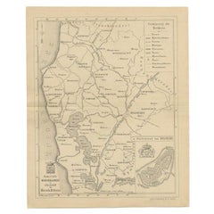
Old Map of The Frisian City of Workum in Holland, 1916
$81.37
$101.7120% Off
£60.78
£75.9720% Off
€68
€8520% Off
CA$112.10
CA$140.1320% Off
A$122.17
A$152.7220% Off
CHF 64.70
CHF 80.8720% Off
MX$1,467.44
MX$1,834.3020% Off
NOK 819.07
NOK 1,023.8420% Off
SEK 753.06
SEK 941.3220% Off
DKK 518.04
DKK 647.5520% Off
About the Item
Antique map Workum titled 'Workum'. Antique map depicting the Frisian city of Workum, the Netherlands.
Artists and Engravers: Lithograph by J. Smulders
Co, Den Haag.
Condition: Good, age-related toning. Please study image carefully.
Date: 1916
Overall size: 35 x 45 cm
Image size: 29 x 38 cm.
- Dimensions:Height: 17.72 in (45 cm)Width: 13.78 in (35 cm)Depth: 0.01 in (0.2 mm)
- Materials and Techniques:
- Period:
- Date of Manufacture:1916
- Condition:
- Seller Location:Langweer, NL
- Reference Number:Seller: BGI-010631stDibs: LU3054325635152
About the Seller
5.0
Recognized Seller
These prestigious sellers are industry leaders and represent the highest echelon for item quality and design.
Platinum Seller
Premium sellers with a 4.7+ rating and 24-hour response times
Established in 2009
1stDibs seller since 2017
2,786 sales on 1stDibs
Typical response time: <1 hour
- ShippingRetrieving quote...Shipping from: Langweer, Netherlands
- Return Policy
More From This Seller
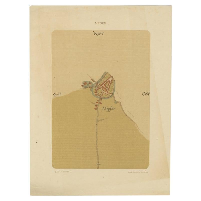
View AllOld Map of the Dutch City of Megen in Holland, 1916
Located in Langweer, NL
Antique map Megen titled 'Megen'. Antique map depicting the city of Megen, Noord-Brabant, The Netherlands.
Artists and Engravers: Lithograph by J. Smulders & Co, Den Haag.
Con...
Category
20th Century Maps
Materials
Paper

$81 Sale Price
20% Off
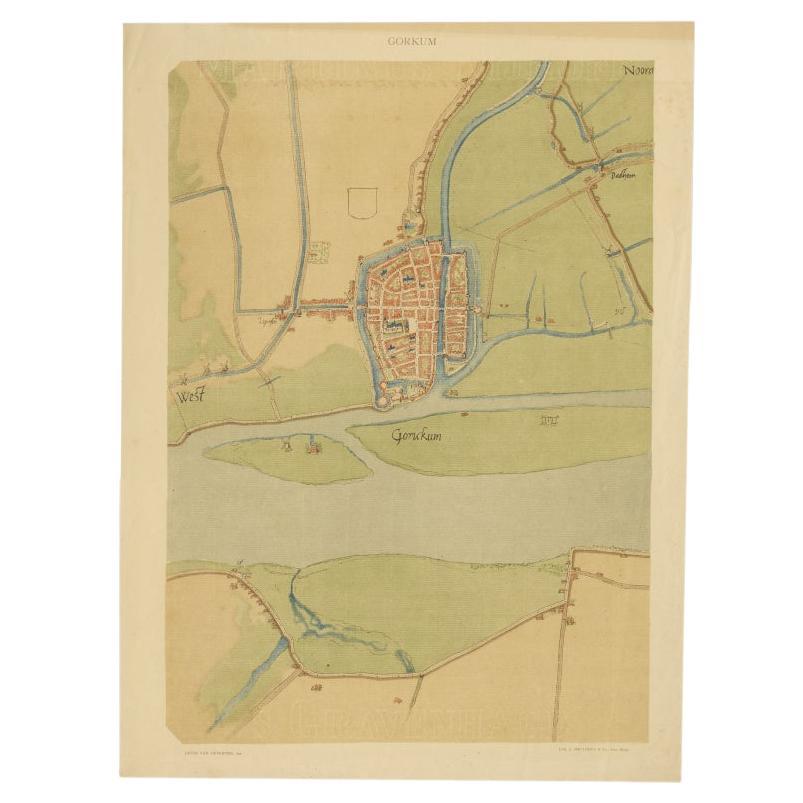
Antique Map of The Dutch City of Gorinchem by Smulders, Lithograph, 1916
Located in Langweer, NL
Antique map Gorinchem titled 'Gorkum'. Antique map depicting the city of Gorinchem, The Netherlands.
Artists and Engravers: Lithograph by J. Smulders & Co, Den Haag.
Condition...
Category
20th Century Maps
Materials
Paper
$71 Sale Price
20% Off
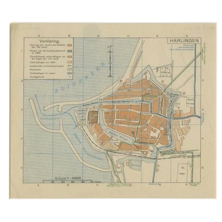
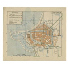
Vintage Map of the Frisian City of Harlingen, 1930
Located in Langweer, NL
Vintage map titled 'Harlingen'. Original map of the city of Harlingen, Friesland, the Netherlands. Published circa 1930.
Condition: Good, passe-partout/matting included. General a...
Category
20th Century Maps
Materials
Paper
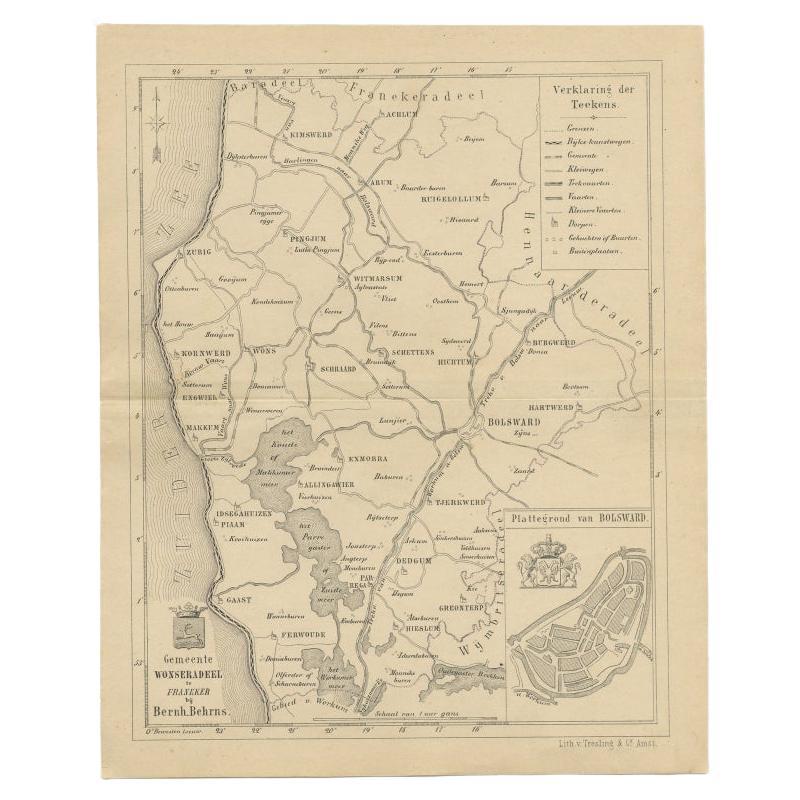
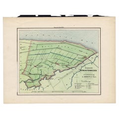
Antique Map of The Wonseradeel Township in Friesland, The Netherlands, 1861
Located in Langweer, NL
Antique map titled 'Gemeente Wonseradeel'. Old map depicting the Wonseradeel township including cities and villages like Kimswerd, Achlum, Arum, Witmarsum, Kornwerd, Hichtum and Bols...
Category
Antique 19th Century Maps
Materials
Paper
$181 Sale Price
20% Off
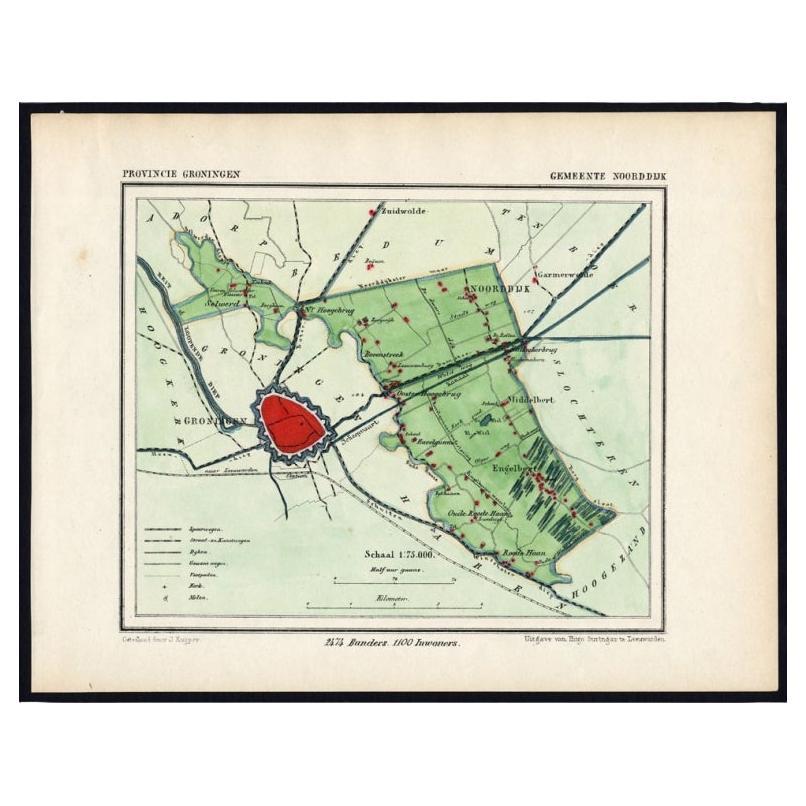
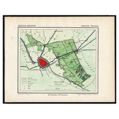
Rare Map of Dutch Municipality Noorddijk Near Groningen, 1865
Located in Langweer, NL
Groningen: Gemeente Engelbert, Middelbert, Noorddijk. These scarse detailed maps of Dutch Towns originate from the 'Gemeente-atlas' of Jacob Kuyper. This atlas of all towns in the Ne...
Category
Antique 19th Century Maps
Materials
Paper
$129 Sale Price
20% Off
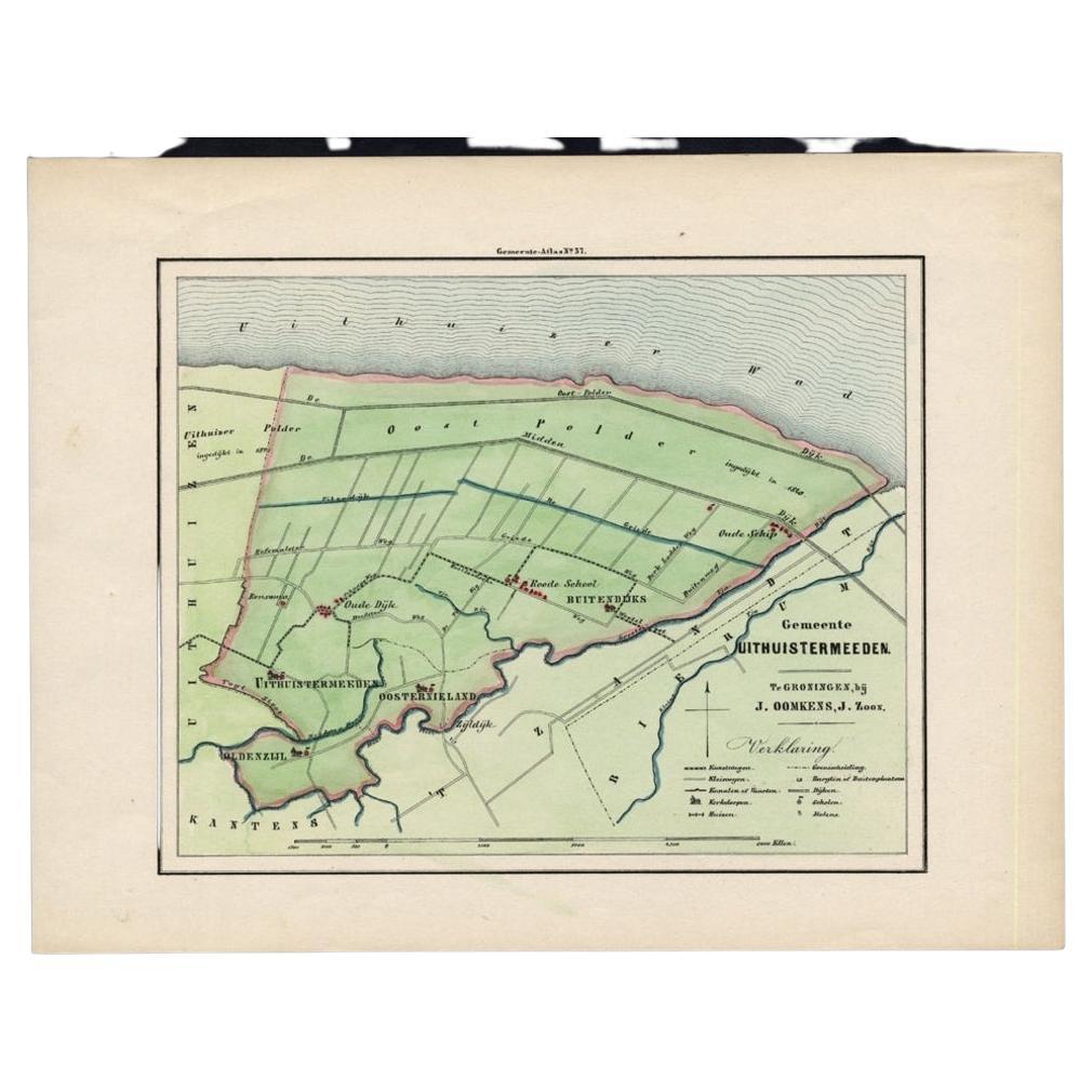
Original Antique Map of the Township of Uithuizermeeden, the Netherlands, 1862
Located in Langweer, NL
Groningen: Gemeente Oldenzijl-Oosternieland-de Roode School-Uithuizermeeden. These scarse detailed maps of Dutch Towns originate from the 'Gemeente atlas van de Provincie Groningen i...
Category
Antique 19th Century Maps
Materials
Paper
$153 Sale Price
20% Off
You May Also Like
Original Antique Map or City Plan of Amsterdam, Netherlands. Circa 1835
Located in St Annes, Lancashire
Nice map of Amsterdam
Drawn and engraved by J.Dower
Published by Orr & Smith. C.1835
Unframed.
Free shipping
Category
Antique 1830s English Maps
Materials
Paper

1752 Vaugoundy Map of Flanders : Belgium, France, and the Netherlands, Ric.a002
Located in Norton, MA
Large Vaugoundy Map of Flanders:
Belgium, France, and the Netherlands
Colored -1752
Ric.a002
Description: This is a 1752 Didier Robert de Vaugondy map of Flanders. The map de...
Category
Antique 17th Century Unknown Maps
Materials
Paper

Original Antique Map or City Plan of Rome, Italy. Circa 1835
Located in St Annes, Lancashire
Nice map of Rome
Drawn and engraved by J.Dower
Published by Orr & Smith. C.1835
Unframed.
Free shipping
Category
Antique 1830s English Maps
Materials
Paper

Utrecht, Antique Map from "Civitates Orbis Terrarum"
By Franz Hogenberg
Located in Roma, IT
Braun G., Hogenberg F., Traiectum or Utrecht, from the collection Civitates Orbis Terrarum, Cologne, T. Graminaeus, 1572-1617.
Very fine B/W aquatint showing a view of Utrecht, with...
Category
16th Century Landscape Prints
Materials
Etching

Original Antique Map or City Plan of Geneva, Switzerland. Circa 1835
Located in St Annes, Lancashire
Nice map of Geneva
Drawn and engraved by J.Dower
Published by Orr & Smith. C.1835
Unframed.
Free shipping
Category
Antique 1830s English Maps
Materials
Paper

1620 Map of Artois Entitled "Artesia Comitatvs Artois, " by Bleau, Ric.a012
Located in Norton, MA
1640 map of Artois entitled
"Artesia Comitatvs Artois,"
by Bleau
Colored
A-012.
Detailed map of the northern province of Artois, France on the border with Belgium. Feature...
Category
Antique 17th Century Dutch Maps
Materials
Paper

More Ways To Browse
The Vintage Map
Dutch City
1916 Furniture
Vintage City Maps
Antique Map Of Egypt
Map Of Austria
New Zealand Map
Antique Linen Map
19th Century World Map
Antique Ohio Maps
Antique Texas Furniture
Military Map
Antique Maps New Zealand
Birds Eye View Map
North Africa Map
West Africa Map
Antique Compass Map
Antique Maps California