Want more images or videos?
Request additional images or videos from the seller
1 of 6
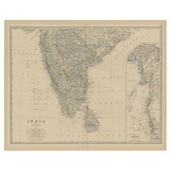
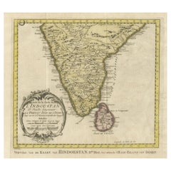
Old Map of India, Sri Lanka, Thailand, Myanmar, Laos, Vietnam, Malaysia, 1779
Price:$528.44
About the Item
- Dimensions:Height: 20.87 in (53 cm)Width: 29.53 in (75 cm)Depth: 0 in (0.02 mm)
- Materials and Techniques:Paper,Engraved
- Period:1770-1779
- Date of Manufacture:1779
- Condition:Very good. Minor wear along original centerfold. Copper engraving. Original outline colour, excellent. Verso: Blank. Strong handmade paper.
- Seller Location:Langweer, NL
- Reference Number:Seller: BG-131261stDibs: LU3054328464282
About the Seller
5.0
Recognized Seller
These prestigious sellers are industry leaders and represent the highest echelon for item quality and design.
Platinum Seller
Premium sellers with a 4.7+ rating and 24-hour response times
Established in 2009
1stDibs seller since 2017
2,816 sales on 1stDibs
Typical response time: 1 hour
Authenticity Guarantee
In the unlikely event there’s an issue with an item’s authenticity, contact us within 1 year for a full refund. DetailsMoney-Back Guarantee
If your item is not as described, is damaged in transit, or does not arrive, contact us within 7 days for a full refund. Details24-Hour Cancellation
You have a 24-hour grace period in which to reconsider your purchase, with no questions asked.Vetted Professional Sellers
Our world-class sellers must adhere to strict standards for service and quality, maintaining the integrity of our listings.Price-Match Guarantee
If you find that a seller listed the same item for a lower price elsewhere, we’ll match it.Trusted Global Delivery
Our best-in-class carrier network provides specialized shipping options worldwide, including custom delivery.You May Also Like
Old Horizontal Map of England
By Tasso
Located in Alessandria, Piemonte
ST/520 - Old rare Italian map of England, dated 1826-1827 - by Girolamo Tasso, editor in Venise, for the atlas of M.r Le-Sage.
Category
Antique Early 19th Century Italian Other Prints
Materials
Paper

Map of the Republic of Genoa
Located in New York, NY
Framed antique hand-coloured map of the Republic of Genoa including the duchies of Mantua, Modena, and Parma.
Europe, late 18th century.
Dimension: 25...
Category
Antique Late 18th Century European Maps

Antique Map of Principality of Monaco
By Antonio Vallardi Editore
Located in Alessandria, Piemonte
ST/619 - "Old Geographical Atlas of Italy - Topographic map of ex-Principality of Monaco" -
ediz Vallardi - Milano -
A somewhat special edition ---
Category
Antique Late 19th Century Italian Other Prints
Materials
Paper

Map "Estuary- Mouth of the Thames"
Located in Alessandria, Piemonte
ST/426 - Antique French Map of the estuary of the Thames, map dated 1769 -
"Mape of the entrance of the Thames. Designed by filing of Navy cards fo...
Category
Antique Mid-18th Century French Other Prints
Materials
Paper

Original Antique Map of Ireland- Kerry. C.1840
Located in St Annes, Lancashire
Great map of Kerry
Steel engraving
Drawn under the direction of A.Adlard
Published by How and Parsons, C.1840
Unframed.
Category
Antique 1840s English Maps
Materials
Paper

Original Antique Map of China, Arrowsmith, 1820
Located in St Annes, Lancashire
Great map of China
Drawn under the direction of Arrowsmith
Copper-plate engraving
Published by Longman, Hurst, Rees, Orme and Brown, 1820
Unfr...
Category
Antique 1820s English Maps
Materials
Paper

Original Antique Map of Europe, Arrowsmith, 1820
Located in St Annes, Lancashire
Great map of Europe
Drawn under the direction of Arrowsmith.
Copper-plate engraving.
Published by Longman, Hurst, Rees, Orme and Brown, 1820
...
Category
Antique 1820s English Maps
Materials
Paper

Original Antique Map of Hungary, Arrowsmith, 1820
Located in St Annes, Lancashire
Great map of Hungary
Drawn under the direction of Arrowsmith.
Copper-plate engraving.
Published by Longman, Hurst, Rees, Orme and Brown, 1820
Unframed.
Category
Antique 1820s English Maps
Materials
Paper

Original Antique Map of South America. C.1780
Located in St Annes, Lancashire
Great map of South America
Copper-plate engraving
Published C.1780
Two small worm holes to left side of map
Unframed.
Category
Antique Early 1800s English Georgian Maps
Materials
Paper

Original Antique Map of South Africa, Arrowsmith, 1820
Located in St Annes, Lancashire
Great map of South Africa.
Drawn under the direction of Arrowsmith.
Copper-plate engraving.
Published by Longman, Hurst, Rees, Orme and Br...
Category
Antique 1820s English Maps
Materials
Paper

More From This Seller
View AllOld Map of Southern India and Ceylon
Sri Lanka
, 1882
Located in Langweer, NL
Antique map titled 'India (Southern Sheet)'.
Old map of Southern India and Ceylon (Sri Lanka). With an inset map of the South-Eastern Provinces of India. This map originates from...
Category
Antique 1880s Maps
Materials
Paper
$278 Sale Price
20% Off
Old Original Map of Chormandel
Malabar, India
Ceylon, Now Sri Lanka, 1726
Located in Langweer, NL
Antique map titled 'Nieuwe Kaart van Choromandel ende Malabar'.
Antique map depicting the southern part of India and the northern tip of Ceylon, Sri Lanka. This map originates from...
Category
Antique 1720s Maps
Materials
Paper
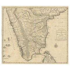
$528 Sale Price
20% Off
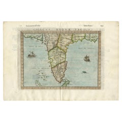
Rare Attractive Antique Map of Asia, India, Sri Lanka, Maldives, 1599
Located in Langweer, NL
Original Antique map of Asia, India, Ceylon (Sri Lanka), Maldives by Rosaccio / Ruscelli in attractive coloring.
Title: Calecut Nuova Tavola
Year: 1599
Relief shown pictorially.
...
Category
Antique 16th Century European Maps
Materials
Paper
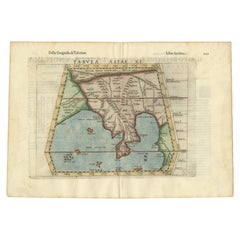
Antique Hand-Coloured Map of India, Sri Lanka, Maldives, ca.1599
Located in Langweer, NL
Title: Tabula Asiae XI - 1599
Very old and decorative map of India, Sri Lanka and the Maledives. Put this map in a frame on the wall and amaze your visitors. This original engravi...
Category
Antique 16th Century Maps
Materials
Paper
Original Antique Map of Southern India and Ceylon
Present-Day Sri Lanka
By Jakob van der Schley
Located in Langweer, NL
Antique map titled 'Suite de la Carte de l'Indoustan (..) - Vervolg van de Kaart van Hindoestan (..)'. Original antique map of Southern India and Ceylon (present-day Sri Lanka). This...
Category
Antique Mid-18th Century Maps
Materials
Paper
$807 Sale Price
20% Off
Original Antique Map showing Southern India, Northern Sri Lanka
Malabar, 1652
Located in Langweer, NL
Antique map titled 'Presqu'Isle de l'Inde deca le Gange (..)'.
Old map showing the southern part of India, including the northern part of Sri Lanka. With inset map of Southern India (Malabar). This map covers the subcontinent from the Bay of Bengal and the Gulf of Cambay to Ceylon. The Mogul Empire can be found in the north. Further south...
Category
Antique 1650s Maps
Materials
Paper

$634 Sale Price
20% Off