Items Similar to Old Map of Java, Indonesia by Stemler, 1875


Want more images or videos?
Request additional images or videos from the seller
1 of 5
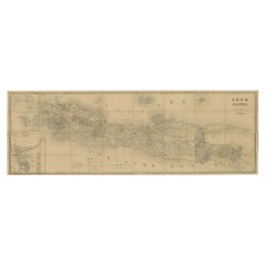
Old Map of Java, Indonesia by Stemler, 1875
$66.93
$83.6720% Off
£50.05
£62.5720% Off
€56
€7020% Off
CA$92.28
CA$115.3520% Off
A$101.28
A$126.6020% Off
CHF 53.22
CHF 66.5320% Off
MX$1,205.19
MX$1,506.4920% Off
NOK 680.35
NOK 850.4420% Off
SEK 621.71
SEK 777.1320% Off
DKK 426.74
DKK 533.4320% Off
About the Item
Antique map titled 'Hoofddriehoeken - Java en madoera.' (Main triangles measured by the Geographical Service in the Dutch-Indies on Java and Madoera.) This scarce map shows the Indonesian island of Java. With scale. Originates from 'Tijdschrift Aardrijkskundig Genootschap', published by C. F. Stemler in Amsterdam, ca. 1875.
Artists and Engravers: Lithographed by Hoffmeister.
Condition: Good, general age related toning; some light staining from handling. Please study image carefully.
Date: c.1875
Overall size: 59 x 27.5 cm.
Image size: 0.001 x 56 x 21.5 cm.
We sell original antique maps to collectors, historians, educators and interior decorators all over the world. Our collection includes a wide range of authentic antique maps from the 16th to the 20th centuries. Buying and collecting antique maps is a tradition that goes back hundreds of years. Antique maps have proved a richly rewarding investment over the past decade, thanks to a growing appreciation of their unique historical appeal. Today the decorative qualities of antique maps are widely recognized by interior designers who appreciate their beauty and design flexibility. Depending on the individual map, presentation, and context, a rare or antique map can be modern, traditional, abstract, figurative, serious or whimsical. We offer a wide range of authentic antique maps for any budget.
- Creator:Stemler (Artist)
- Dimensions:Height: 10.83 in (27.5 cm)Width: 23.23 in (59 cm)Depth: 0 in (0.01 mm)
- Materials and Techniques:
- Period:
- Date of Manufacture:circa 1875
- Condition:
- Seller Location:Langweer, NL
- Reference Number:Seller: PCT-145311stDibs: LU3054325639272
About the Seller
5.0
Recognized Seller
These prestigious sellers are industry leaders and represent the highest echelon for item quality and design.
Platinum Seller
Premium sellers with a 4.7+ rating and 24-hour response times
Established in 2009
1stDibs seller since 2017
2,800 sales on 1stDibs
Typical response time: <1 hour
- ShippingRetrieving quote...Shipping from: Langweer, Netherlands
- Return Policy
More From This Seller
View AllAntique Map of the Region of Lampung, Sumatra, Indonesia, 1900
Located in Langweer, NL
Antique map of the region of Lampung, Sumatra. Also depicting part of Palembang and Java. This map originates from 'Atlas van Nederlandsch Oost- en West-Indië' by I. Dornseiffen.
A...
Category
20th Century Maps
Materials
Paper

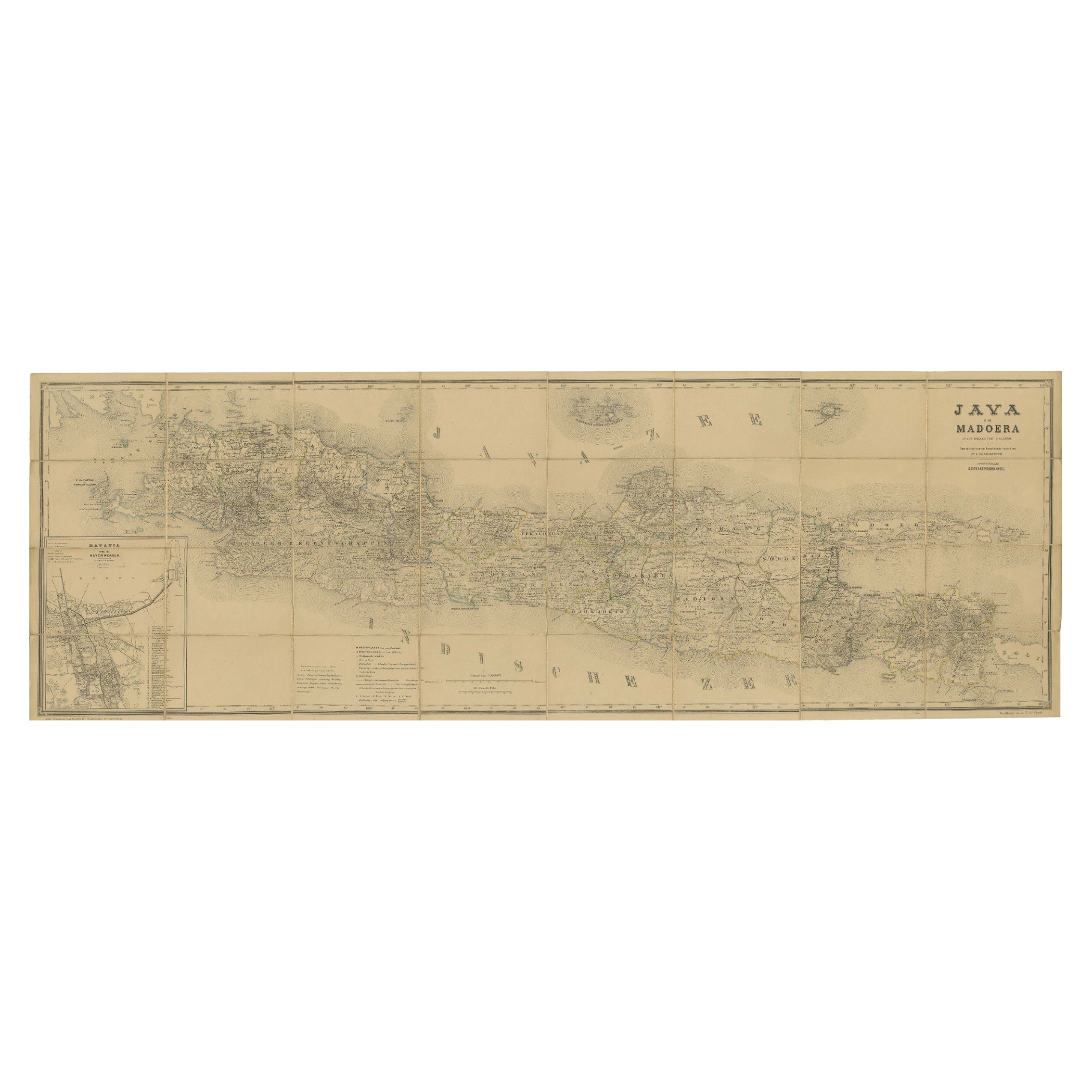
Large Antique Map of Java
Madura with Batavia Inset, c.1870s Dutch East Indies
Located in Langweer, NL
Large Antique Map of Java & Madura with Batavia Inset, c.1870s Dutch East Indies
This finely detailed 19th-century Dutch colonial map is titled “Java en Madoera op den schaal van 1:...
Category
Antique 1870s Dutch Maps
Materials
Paper
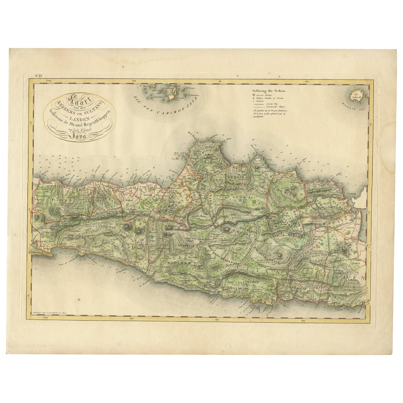
Antique Map of Central and East Java by Van den Bosch, 1818
Located in Langweer, NL
Antique map titled 'Kaart van de Keizers en Sultans Landen benevens de Strand Regentschappen op het Eiland Java'. Map of three central and easterly provinces of the island of Java. O...
Category
Antique Early 19th Century Maps
Materials
Paper

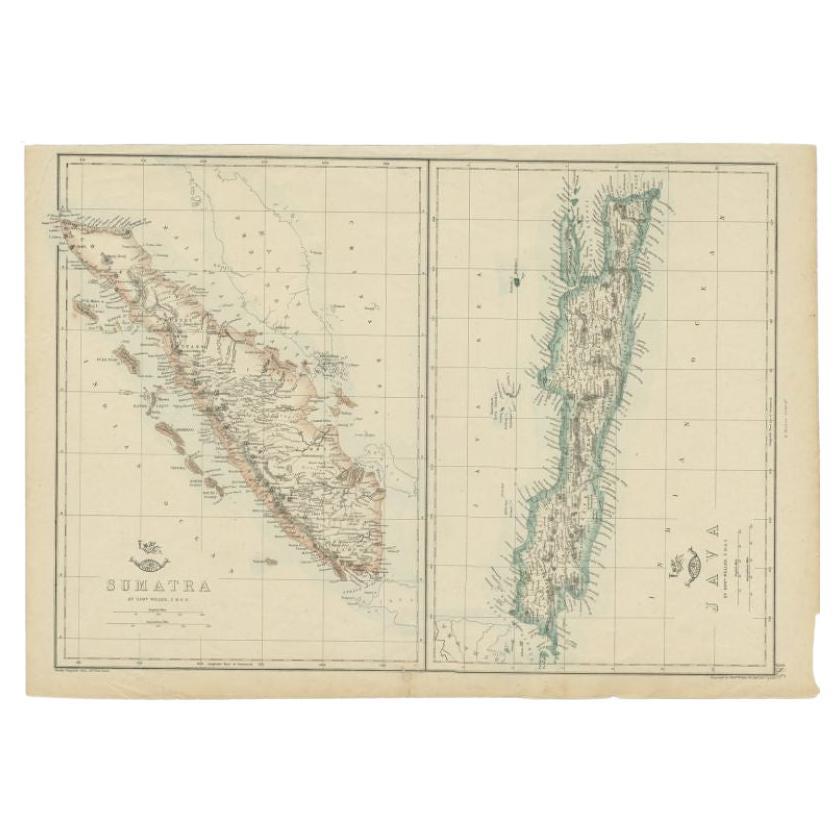
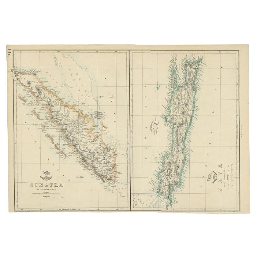
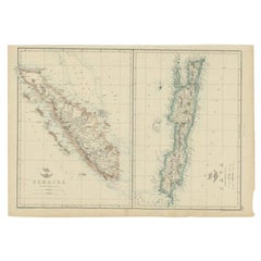
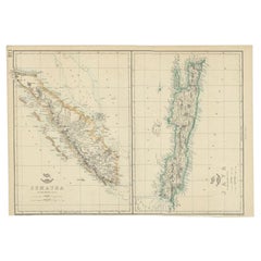
Antique Map of Sumatra and Java by Weller, c.1860
Located in Langweer, NL
Antique map titled 'Sumatra, Java'. A delicately presented and detailed pair of maps of the two islands. The plate appeared in the part-work "Dispatch Atlas" issued in supplements an...
Category
Antique 19th Century Maps
Materials
Paper
$117 Sale Price
20% Off
Antique Map of the East Indies by Van der Aa
1849
Located in Langweer, NL
Antique map titled 'Kaart van Nederlands OostIndie door A.J. van der Aa'. Old map of the Dutch East Indies. This map originates from 'Nederlands Oost-Indië, of beschrijving der Neder...
Category
Antique Mid-19th Century Maps
Materials
Paper

Antique Map of Sumatra and Java by Weller, c.1860
Located in Langweer, NL
Antique map titled 'Sumatra, Java'. A delicately presented and detailed pair of maps of the two islands. The plate appeared in the part-work "Dispatch Atlas" issued in supplements an...
Category
Antique 19th Century Maps
Materials
Paper
$127 Sale Price
20% Off
You May Also Like
Large Original Antique Map of Java and Borneo, Fullarton, C.1870
Located in St Annes, Lancashire
Great map of Java and Borneo
Wonderful figurative borders
From the celebrated Royal Illustrated Atlas
Lithograph. Original color.
Published by Fullarton, Edinburgh. C.1870
Unfr...
Category
Antique 1870s Scottish Maps
Materials
Paper

Map Of The Island Of Cuba - Guillaume Thomas Raynal (1711-1796)
Located in Porto, PT
This historical map of the Island of Cuba was produced in the late 18th century and is taken from an edition of “Atlas de toutes les parties connues du globe terrestre” by the French...
Category
Antique 18th Century Prints
Materials
Glass, Paper

Map Colonies Francaises Martinique, 1845
Located in BUNGAY, SUFFOLK
Colonies Francaises, Martinique, Amerique DU SUD
Geographie et Statistique par V.Levasseur. Ing'r Geographe.
Illustre par Raymond Bonheur, peintre.
Grave par Laguihermie, Rue St...
Category
Antique 19th Century French Maps
Materials
Paper

Original Antique Map of Central America / Florida, Arrowsmith, 1820
Located in St Annes, Lancashire
Great map of Central America.
Drawn under the direction of Arrowsmith.
Copper-plate engraving.
Published by Longman, Hurst, Rees, Orme and Brown, 1820
Unframed.
Category
Antique 1820s English Maps
Materials
Paper

Large Original Antique Map of The West Indies by Sidney Hall, 1847
Located in St Annes, Lancashire
Great map of The West Indies
Drawn and engraved by Sidney Hall
Steel engraving
Original colour outline
Published by A & C Black. 1847
Unframed
Free shipping.
Category
Antique 1840s Scottish Maps
Materials
Paper

Antique 1803 Italian Map of Asia Including China Indoneseia India
Located in Amsterdam, Noord Holland
Antique 1803 Italian Map of Asia Including China Indoneseia India
Very nice map of Asia. 1803.
Additional information:
Type: Map
Country of Manufacturing: Europe
Period: 19th centu...
Category
Antique 19th Century European Maps
Materials
Paper

$438 Sale Price
39% Off
More Ways To Browse
Java Furniture
Antique Texas Furniture
Military Map
Antique Maps New Zealand
Birds Eye View Map
North Africa Map
West Africa Map
Antique Compass Map
Antique Maps California
Biblical Maps
Hungary Map
Maps Of Mediterranean
Treasure Map
Antique Navigational Tools
Mississippi Furniture
Caribbean Antiques
Antique Maps West Indies
Antique Mozambique