Items Similar to Old Map of the Philippines and Part of Indonesia
Spice Islands
, 1744


Want more images or videos?
Request additional images or videos from the seller
1 of 6
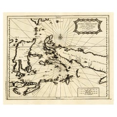
Old Map of the Philippines and Part of Indonesia
Spice Islands
, 1744
$634.60
$793.2520% Off
£470.07
£587.5920% Off
€528
€66020% Off
CA$868.12
CA$1,085.1420% Off
A$946.20
A$1,182.7520% Off
CHF 500.25
CHF 625.3120% Off
MX$11,390.47
MX$14,238.0920% Off
NOK 6,349.40
NOK 7,936.7520% Off
SEK 5,821.10
SEK 7,276.3720% Off
DKK 4,023.07
DKK 5,028.8420% Off
About the Item
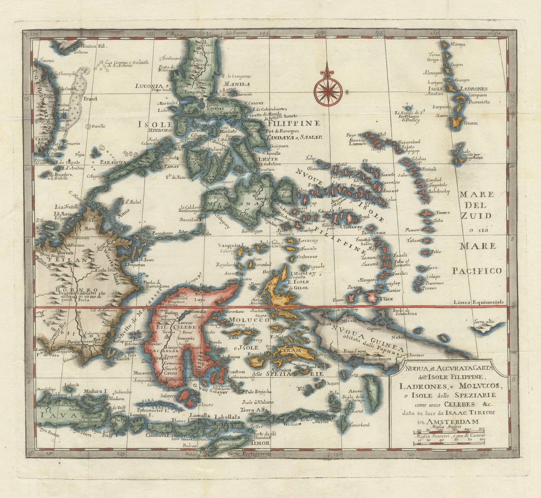
Antique map titled 'Nieuwe Kaart van de Filippynsche, Ladrones, Moluccos of Specery Eilanden, als mede Celebes etc'.
Old map of the Philippines and part of Indonesia. Originates from 'Nieuwe Hand-Atlas, bestaande in eene Verzameling van eenige naauwkeurige Landkaarten (..)'.
Artists and Engravers: Published by I. Tirion, Amsterdam.
- Dimensions:Height: 13.19 in (33.5 cm)Width: 15.75 in (40 cm)Depth: 0 in (0.02 mm)
- Materials and Techniques:
- Period:1740-1749
- Date of Manufacture:1744
- Condition:Wear consistent with age and use. Condition: Very good, please study image carefully.
- Seller Location:Langweer, NL
- Reference Number:Seller: BG-11746 1stDibs: LU3054327135072
About the Seller
5.0
Recognized Seller
These prestigious sellers are industry leaders and represent the highest echelon for item quality and design.
Platinum Seller
Premium sellers with a 4.7+ rating and 24-hour response times
Established in 2009
1stDibs seller since 2017
2,813 sales on 1stDibs
Typical response time: 1 hour
- ShippingRetrieving quote...Shipping from: Langweer, Netherlands
- Return Policy
More From This Seller
View All1738 Map of the Philippines
Eastern Indonesia: Spice Islands by Tirion
Located in Langweer, NL
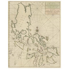
1738 Map of the Philippines & Eastern Indonesia: Spice Islands by Tirion/Albrizzi
This beautifully hand-colored map from circa 1738, created by Tirion and Albrizzi, showcases the Philippines and the eastern part of Indonesia, reflecting the Dutch colonial interests in the region.
The map features a detailed representation of the numerous islands, including the renowned Spice or Banda Islands, pivotal to the Dutch spice trade.
Key regions include the Philippines (Isole Filippine), the Mariana Islands (Ladrones), with Guam, the Caroline and Palau Islands (Nieuwe Fillippynsche Eilenden), the Moluccas (Moluccos) known as the Spice Islands, the eastern tip of Java and Borneo, and a portion of Papua New Guinea.
Measuring 12.8 inches wide by 11.1 inches high, the map is in excellent condition with a crisp impression, slight foxing, and minor printer's creases, printed on a bright sheet with a lion watermark.
Keywords:
- Philippines historical map
- Eastern Indonesia map...
Category
Antique 1730s European Maps
Materials
Paper

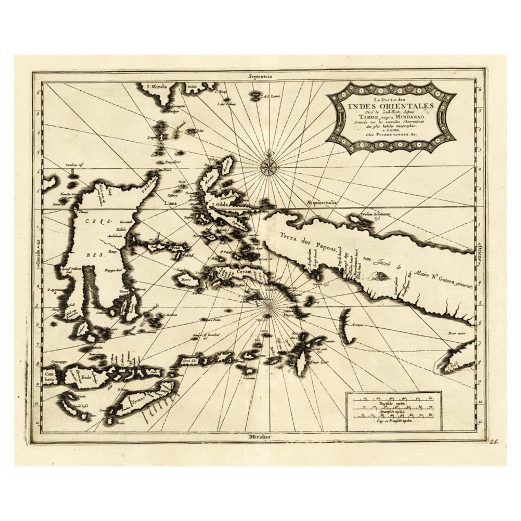
Extremely Rare Map of the East-Indies towards the South-East
Indonesia
, 1725
Located in Langweer, NL
Antique map titled 'La partie des Indes Orientales vers le Zud-Est, depuis Timor jusqu'a Midanao (...).' (The part of the East-Indies towards the South-East, from Timor to Mindanao.)...
Category
Antique 1720s Maps
Materials
Paper
$1,105 Sale Price
20% Off
Original Antique Map of the Philippines, Malaysia, Indonesia, Singapore, c.1690
Located in Langweer, NL
Antique map titled 'Isole dell' Indie, diuise in Filippine, Molucche e della Sonda'.
Old map of the Philippines, Malaysia, Indonesia, Singapore, Northern Australia and contiguous i...
Category
Antique 1690s Italian Maps
Materials
Paper

$2,163 Sale Price
20% Off
Free Shipping
Antique Map of the Indonesian and Philippine Archipelagos by R. de Vaugondy
Located in Langweer, NL
Striking and highly detailed map of the region from Sumatra and Malaca and Southern China to the Philipines, New Guinea and Northern Australia, centered on Borneo. Includes a large i...
Category
Antique Mid-18th Century Maps
Materials
Paper

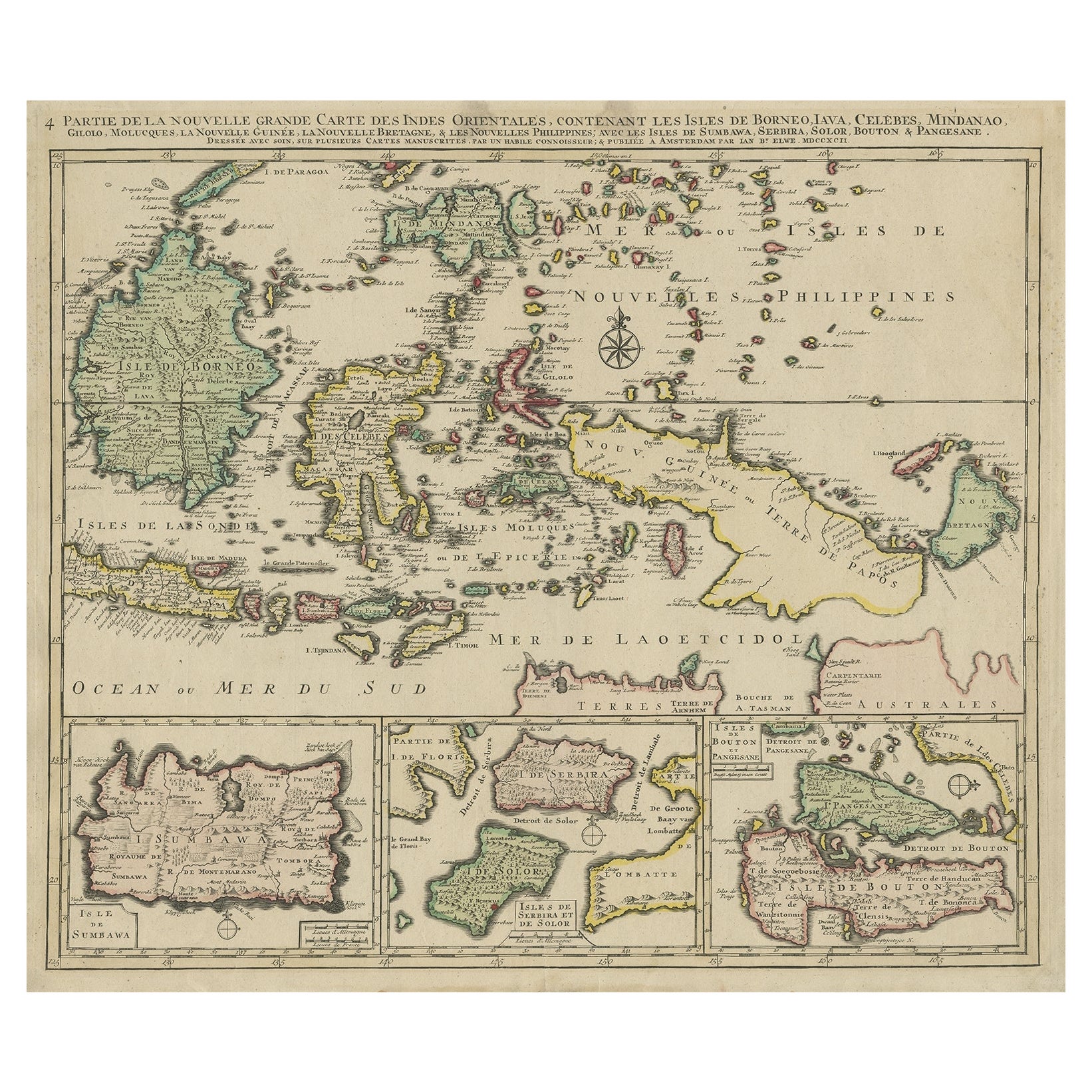
Old Map of the East Indonesian Islands Borneo, Celebes, New Guinea, Bali, 1792
Located in Langweer, NL
Antique map titled 'Partie de la Nouvelle Grande Carte des Indes Orientales, contenant les Isles de Borneo, Iava, Celebes, Mindanao (..)'.
Detailed map of the Indonesian islands ...
Category
Antique 1790s Maps
Materials
Paper

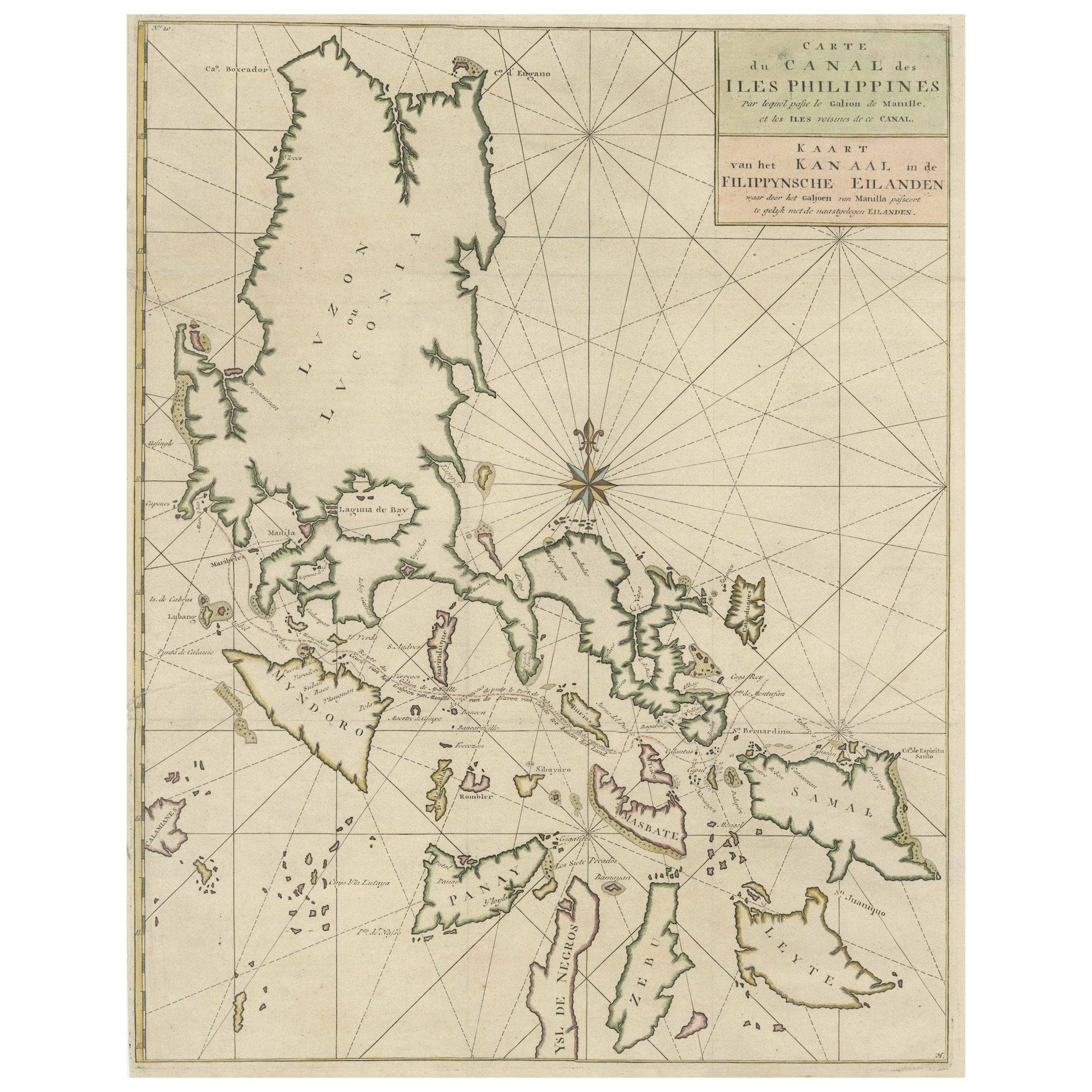
Original Old Map with Many Details Around Manilla in the Philippine Islands
By F. Valentijn
Located in Langweer, NL
Original antique map titled 'Carte du Canal des Iles Philippines (..) - Kaart van het Kanaal in de Filippynsche Eilanden (..)'. Striking and highly detailed chart of the Islands of the Philippines. Shows Islands, bays, reefs, soundings tracks of the Manila Galleon route, etc. Published 1724-1726 by Joannes van Braam...
Category
Antique Early 18th Century Maps
Materials
Paper
$1,057 Sale Price
20% Off
You May Also Like
Original Antique Map of The Philippines. C.1900
Located in St Annes, Lancashire
Fabulous map of The Philippines
Original color.
Engraved and printed by the George F. Cram Company, Indianapolis.
Published, C.1900.
Unframed.
Free shipping.
Category
Antique 1890s American Maps
Materials
Paper

Original Antique Map of South East Asia by Thomas Clerk, 1817
Located in St Annes, Lancashire
Great map of South East Asia
Copper-plate engraving
Drawn and engraved by Thomas Clerk, Edinburgh.
Published by Mackenzie And Dent, 1817
Unframed.
Category
Antique 1810s English Maps
Materials
Paper

Map of the East Indies: An Original 18th Century Hand-colored Map by E. Bowen
Located in Alamo, CA
This is an original 18th century hand-colored map entitled "An Accurate Map of the East Indies Exhibiting the Course of the European Trade both on the Continent and Islands" by Emanu...
Category
Mid-18th Century Old Masters Landscape Prints
Materials
Engraving

$1,020 Sale Price
20% Off
Antique 1803 Italian Map of Asia Including China Indoneseia India
Located in Amsterdam, Noord Holland
Antique 1803 Italian Map of Asia Including China Indoneseia India
Very nice map of Asia. 1803.
Additional information:
Type: Map
Country of Manufacturing: Europe
Period: 19th centu...
Category
Antique 19th Century European Maps
Materials
Paper

$438 Sale Price
39% Off
Antique French Map of Asia Including China Indoneseia India, 1783
Located in Amsterdam, Noord Holland
Very nice map of Asia. 1783 Dedie au Roy.
Additional information:
Country of Manufacturing: Europe
Period: 18th century Qing (1661 - 1912)
Condition: Overall Condition B (Good Used)...
Category
Antique 18th Century European Maps
Materials
Paper

$486 Sale Price
40% Off
Antique Map - Mare Pacificum - Etching by Johannes Janssonius - 1650s
By Johannes Janssonius
Located in Roma, IT
Mare Pacificum is an antique map realized in 1650 by Johannes Janssonius (1588-1664).
The Map is Hand-colored etching, with coeval watercolorang.
Good conditions with slight foxing...
Category
1650s Modern Figurative Prints
Materials
Etching
