Items Similar to Old Original Antique Map of Western Canada, 1882

Want more images or videos?
Request additional images or videos from the seller
1 of 5
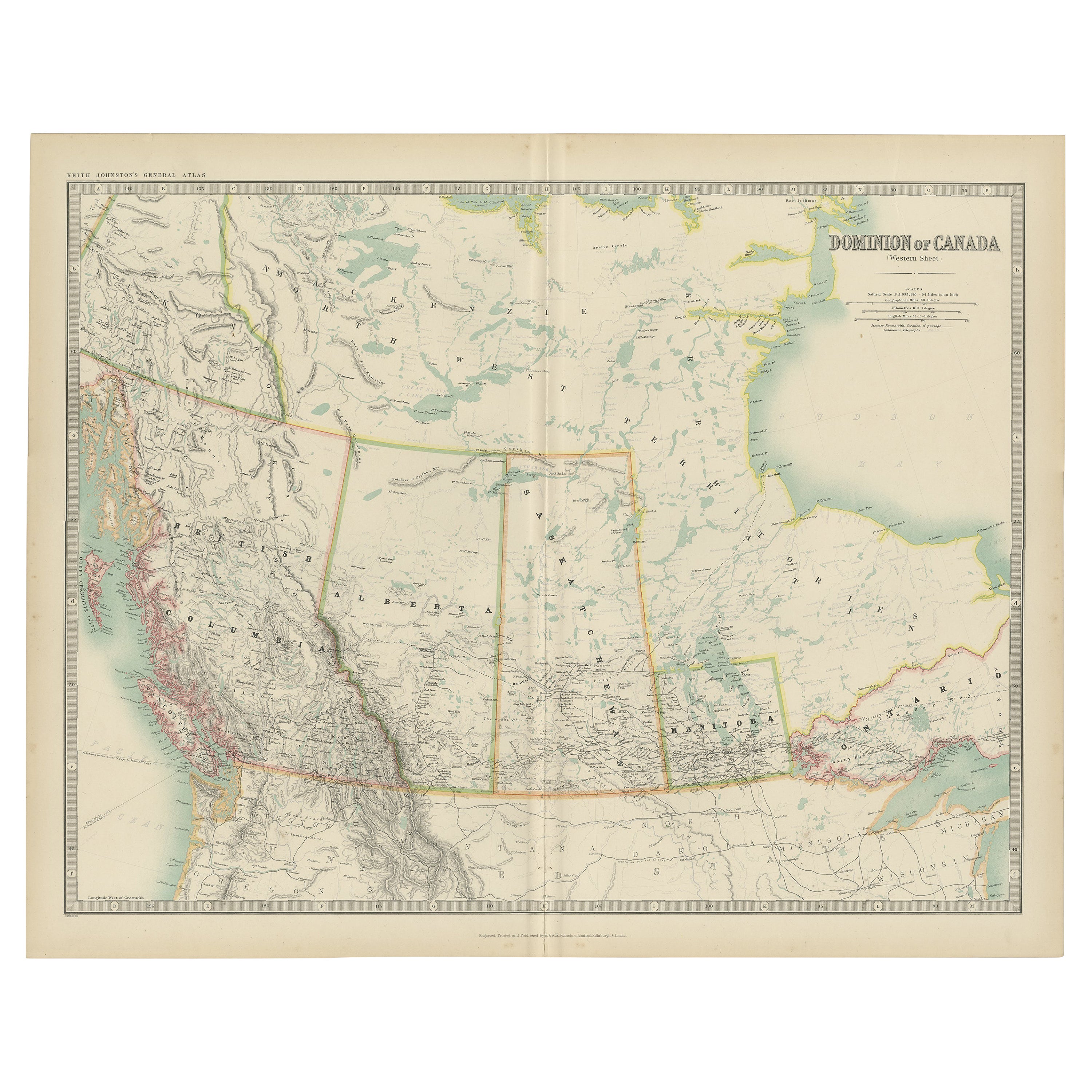
Old Original Antique Map of Western Canada, 1882
$335.99
£248.99
€280
CA$459.20
A$499.87
CHF 265.33
MX$6,014.56
NOK 3,362.13
SEK 3,080.66
DKK 2,132.84
About the Item
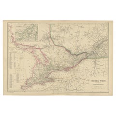
Antique map titled 'Dominion of Canada'.
Old map of Western Canada. This map originates from 'The Royal Atlas of Modern Geography, Exhibiting, in a Series of Entirely Original and Authentic Maps, the Present Condition of Geographical Discovery and Research in the Several Countries, Empires, and States of the World' by A.K. Johnston. Published by W. and A.K. Johnston, 1882.
Artists and Engravers: Alexander Keith Johnston LLD (1804-1871) was a Scottish geographer. He was a pupil of the Edinburgh engraver and mapmaker, James Kirkwood. In 1826, he joined his brother William (who would become Sir William Johnston, Lord Provost of Edinburgh) in a printing and engraving business, forming the well-known cartographical firm of W. and A. K. Johnston.
Condition: Good, general age-related toning. Please study image carefully.
About the Seller
5.0
Recognized Seller
These prestigious sellers are industry leaders and represent the highest echelon for item quality and design.
Platinum Seller
Premium sellers with a 4.7+ rating and 24-hour response times
Established in 2009
1stDibs seller since 2017
2,816 sales on 1stDibs
Typical response time: 1 hour
- ShippingRetrieving quote...Shipping from: Langweer, Netherlands
- Return Policy
More From This Seller
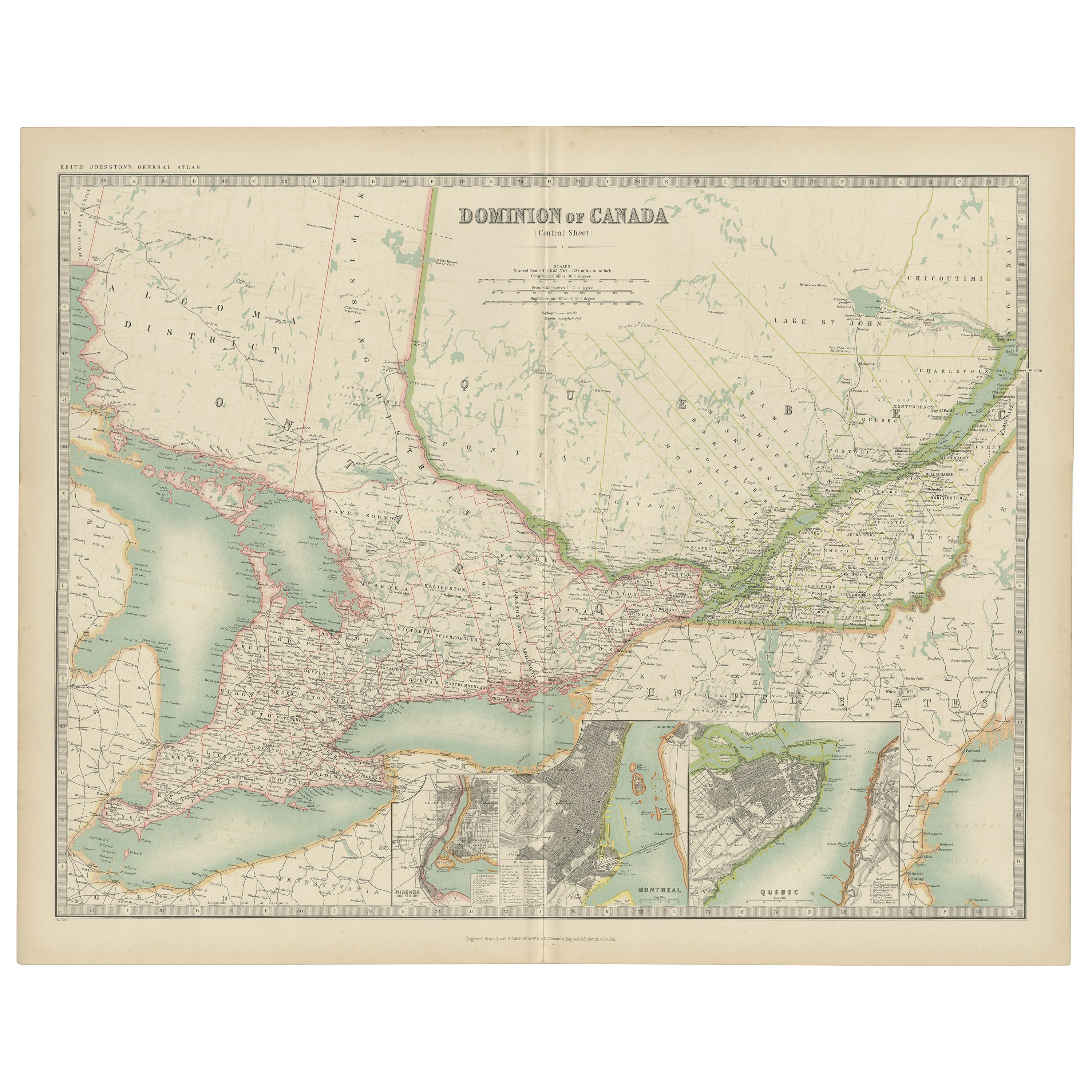
View AllAntique Map of Canada by Johnston
1909
Located in Langweer, NL
Antique map titled 'Dominion of Canada'. Original antique map of Canada. This map originates from the ‘Royal Atlas of Modern Geography’. Publishe...
Category
Early 20th Century Maps
Materials
Paper
$239 Sale Price
20% Off
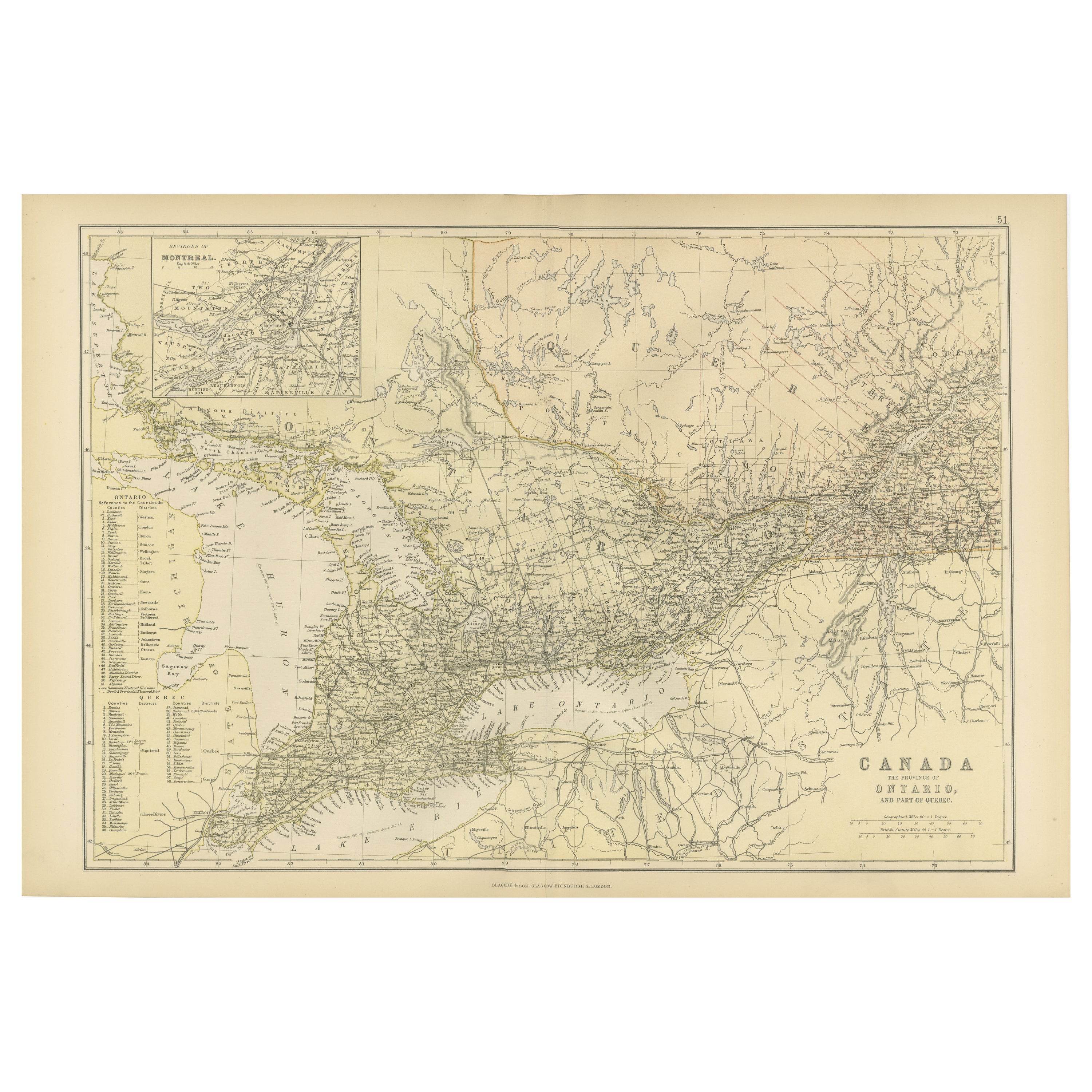
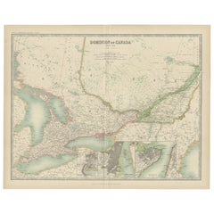
Antique Map of Canada, The Province of Ontario and Part of Quebec, 1882
Located in Langweer, NL
This is a historical map from the 1882 Blackie Atlas, this time detailing "The Province of Ontario, and Part of Quebec" in Canada. The map presents a detailed illustration of Ontario...
Category
Antique 1880s Maps
Materials
Paper

$239 Sale Price
20% Off
Free Shipping
Antique Map of Canada by Johnston
1909
Located in Langweer, NL
Antique map titled 'Dominion of Canada'. Original antique map of Canada. With inset maps of Niagara, Montreal, Quebec. This map originates from t...
Category
Early 20th Century Maps
Materials
Paper
$239 Sale Price
20% Off
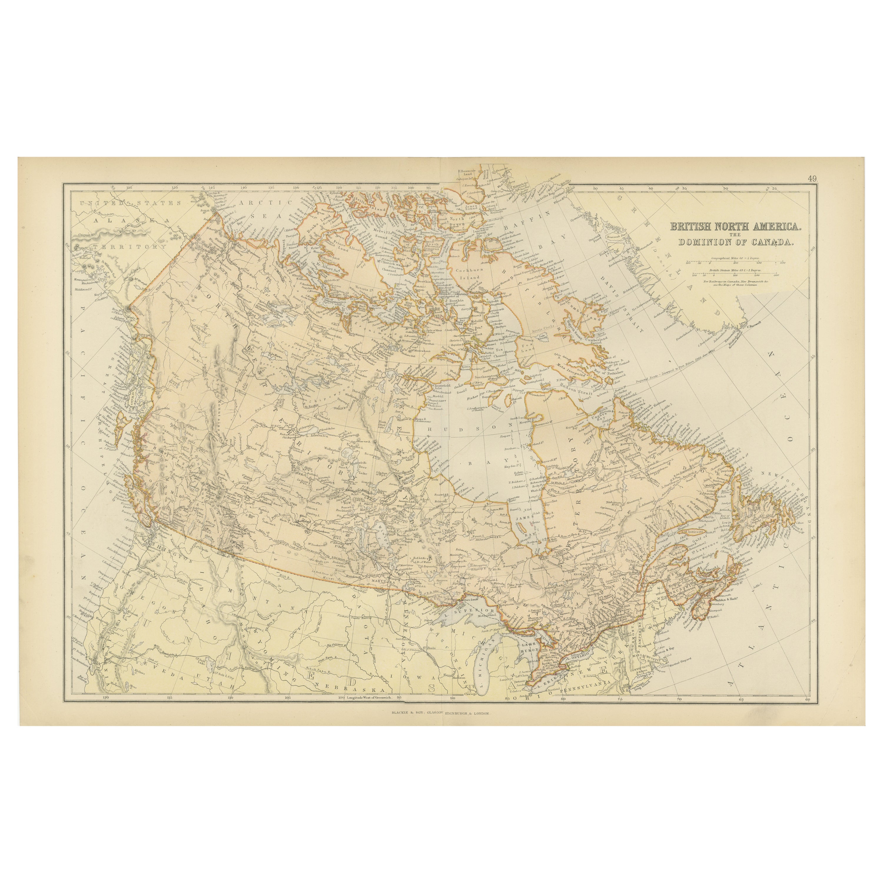
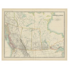
Antique Map of British North America, The Dominion of of Canada, 1882
Located in Langweer, NL
This map is titled "British North America, Dominion of Canada," from the 1882 Blackie Atlas. It features the geographical area that comprises modern-day Canada, with notable features...
Category
Antique 1880s Maps
Materials
Paper

Antique Map of Eastern Canada with an inset Map of Newfoundland, 1882
Located in Langweer, NL
Antique map titled 'Dominion of Canada'. Old map of Eastern Canada with an inset map of Newfoundland. This map originates from 'The Royal Atlas of Modern Geography, Exhibiting, in a ...
Category
Antique 19th Century Maps
Materials
Paper

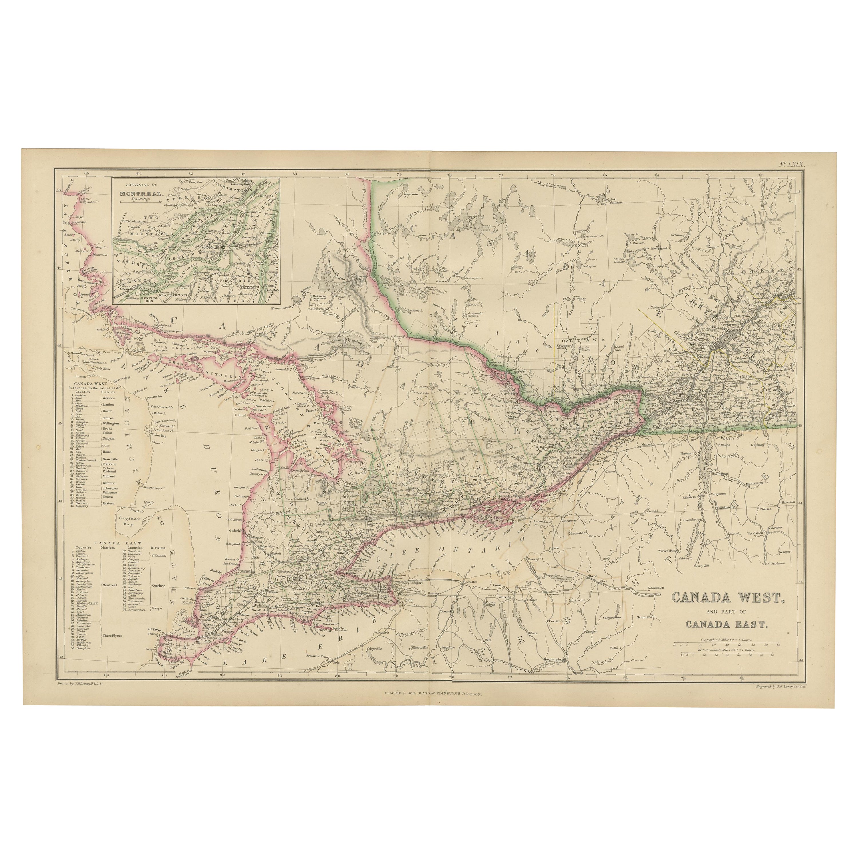
Antique Map of Canada West and Part of Canada East by W. G. Blackie, 1859
Located in Langweer, NL
Antique map titled 'Canada West and Part of Canada East'. Original antique map of Canada West and Part of Canada East with inset map of Montreal. This ...
Category
Antique Mid-19th Century Maps
Materials
Paper
$239 Sale Price
20% Off
You May Also Like
Manitoba, British Columbia and NW Territories, Canada. Century Atlas antique map
Located in Melbourne, Victoria
'The Century Atlas. Manitoba, British Columbia and the Northwest Territories, Canada, North America.'
Original antique map, 1903.
Central fold as issued. Map name and number printe...
Category
Early 20th Century Victorian More Prints
Materials
Lithograph

Canada and Newfoundland. Century Atlas antique vintage map
Located in Melbourne, Victoria
'The Century Atlas. Dominion of Canada and Newfoundland.'
Original antique map, 1903.
Central fold as issued. Map name and number printed on the reverse corners.
Sheet 29.5cm by 40...
Category
Early 20th Century Victorian More Prints
Materials
Lithograph

Quebec. Canada. Century Atlas antique vintage map
Located in Melbourne, Victoria
'The Century Atlas. Quebec'
Original antique map, 1903.
Inset maps 'Sketch Map of Quebec', Quebec and Vicinity; and 'Montreal and Vicinity'.
Central fo...
Category
Early 20th Century Victorian More Prints
Materials
Lithograph

Original Antique Map of New Brunswick and Nova Scotia, 1889
Located in St Annes, Lancashire
Great map of New Brunswick and Nova Scotia
Drawn and Engraved by W. & A.K. Johnston
Published By A & C Black, Edinburgh.
Original colour
Unfr...
Category
Antique 1880s Scottish Victorian Maps
Materials
Paper

Large Original Vintage Map of North America, circa 1920
Located in St Annes, Lancashire
Great map of North America
Original color. Good condition
Published by Alexander Gross
Unframed.
Category
Vintage 1920s English Edwardian Maps
Materials
Paper

Original Antique Map of the American State of Michigan ( Northern Part ), 1903
Located in St Annes, Lancashire
Antique map of Michigan ( Northern part )
Published By A & C Black. 1903
Original colour
Good condition
Unframed.
Free shipping
Category
Antique Early 1900s English Maps
Materials
Paper

More Ways To Browse
Persian Maps
Afghanistan Antique Map
Antique Furniture Delaware
Antique Furniture Wisconsin
Antique Map By Coronelli
Antique Map Iceland
Cyprus Antique Maps
John Speed Maps
M Howard
Used Office Furniture Michigan
Antique Geological Maps
Antique Manitoba
Australian Colonial
Bengal Map
Stanford Furniture
Tennessee Antique Furniture
Used Furniture Alabama
Used Office Furniture Maine