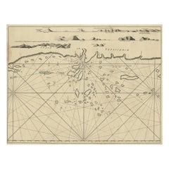
Items Similar to Old Sea Charts of Tourane Bay
the Con Dao Islands
Pulo Condor
, Vietnam, 1780


Want more images or videos?
Request additional images or videos from the seller
1 of 5
Old Sea Charts of Tourane Bay
the Con Dao Islands
Pulo Condor
, Vietnam, 1780
$781.24
£578.69
€650
CA$1,068.70
A$1,164.83
CHF 615.84
MX$14,022.36
NOK 7,816.49
SEK 7,166.13
DKK 4,952.64
About the Item
Description: Two maps on one sheet titled 'Carte d'une partie de la Cote de Cochinchine [and] Plan de l'Isle Condor'.
Sea charts of the coast of Vietnam around the Tourane Bay and the Con Dao Islands (Pulo Condor). Originates from 'Neptune Orientale'.
Artists and Engravers: Jean-Baptiste-Nicolas-Denis d'Apres de Mannevillette (1707-1780) was a French hydrographer and cartographer.
Condition: Very good, please study image carefully.
- Dimensions:Height: 21.66 in (55 cm)Width: 14.57 in (37 cm)Depth: 0 in (0.02 mm)
- Materials and Techniques:
- Period:1780-1789
- Date of Manufacture:1780
- Condition:
- Seller Location:Langweer, NL
- Reference Number:Seller: BGJC-00240 1stDibs: LU3054326636542
About the Seller
5.0
Recognized Seller
These prestigious sellers are industry leaders and represent the highest echelon for item quality and design.
Platinum Seller
Premium sellers with a 4.7+ rating and 24-hour response times
Established in 2009
1stDibs seller since 2017
2,813 sales on 1stDibs
Typical response time: 1 hour
- ShippingRetrieving quote...Shipping from: Langweer, Netherlands
- Return Policy
More From This Seller
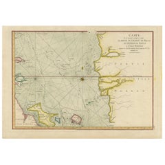
View AllChart of the Coast of Cochinchina
and
Plan of Pulo Condor
, Vietnam, 1778
Located in Langweer, NL
Antique map titled 'A Chart of a part of the Coast of Cochinchina' and 'Plan of Pulo Condor'.
Two maps on one sheet. The upper map shows part of the coast of Cochinchina from Cha...
Category
Antique 1770s Maps
Materials
Paper
$519 Sale Price
20% Off
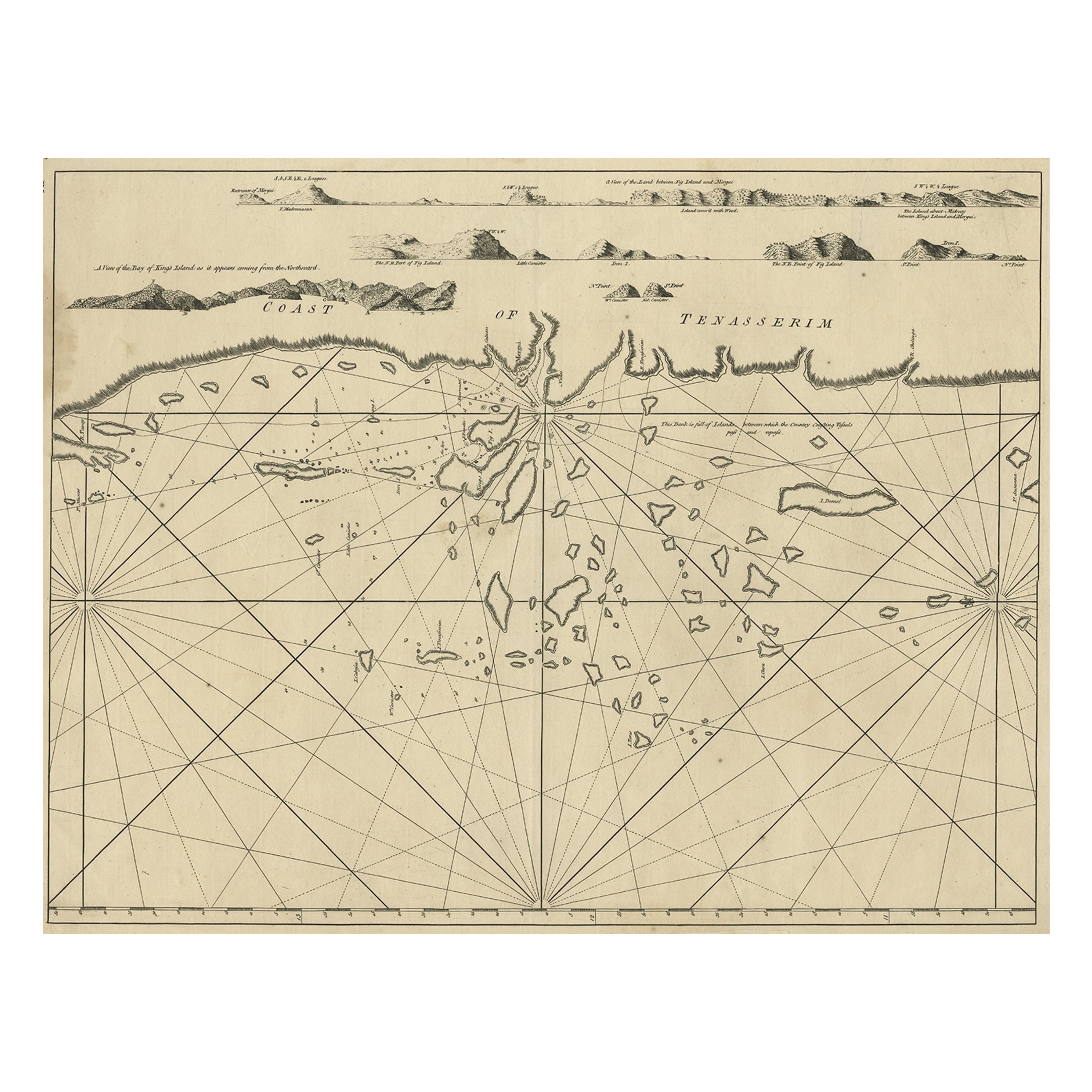
Old Sea Chart of the Tenasserim area, Myanmar
Burma
in South East Asia, c.1790
Located in Langweer, NL
Antique map titled 'Coast of Tenasserim.'
Sea chart of the Tenasserim area, Myanmar in South East Asia. Source unknown, to be determined.
Artists and Engravers: Anonymous.
Category
Antique 1790s Maps
Materials
Paper
$711 Sale Price
20% Off
Antique Map of Quinam and the Côn ?ao Islands by Sayer, 1778
Located in Langweer, NL
Antique map titled 'A Chart of a part of the Coast of Cochinchina' and 'Plan of Pulo Condor'. Two maps on one sheet. The upper map shows part of the coast of Cochinchina from Cham Co...
Category
Antique 18th Century Maps
Materials
Paper

$317 Sale Price
20% Off
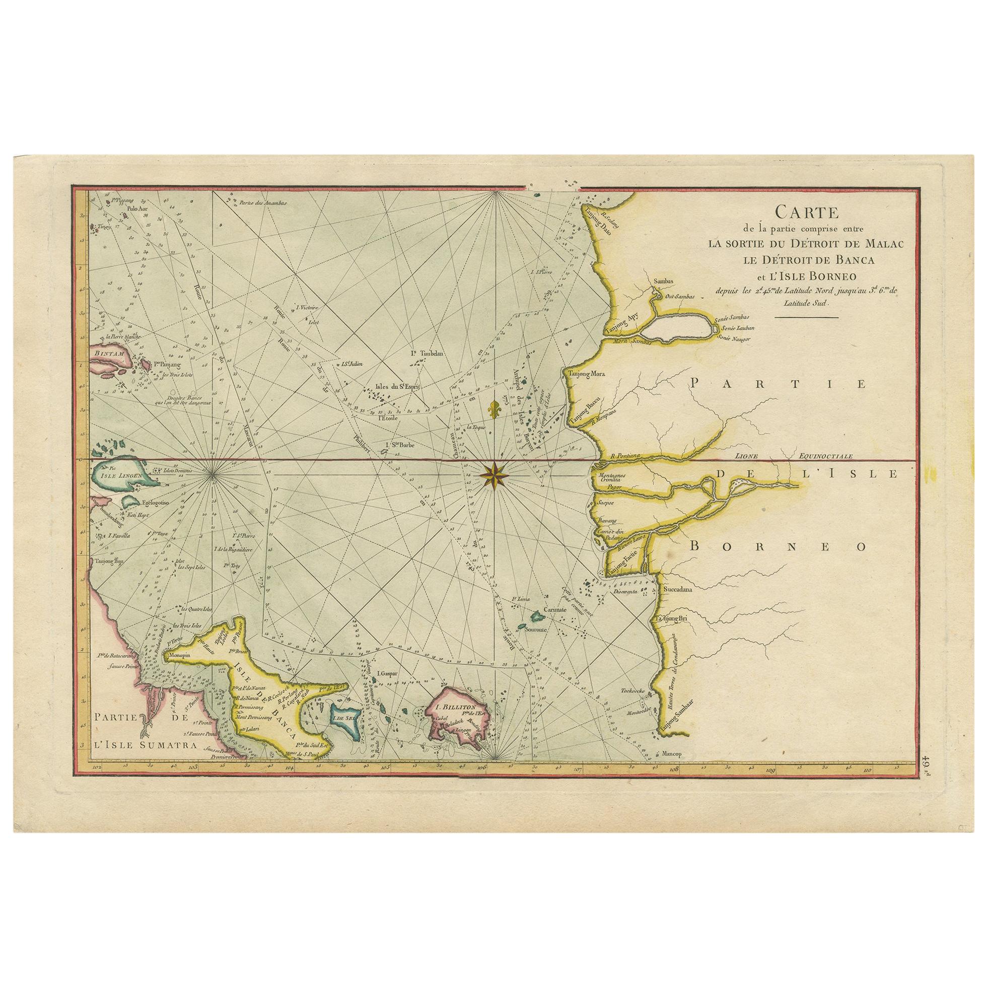
Antique Map of the Malacca and Bangka Strait by De Mannevillette
1775
Located in Langweer, NL
Antique map titled 'Carte de la Partie Comprise entre la Sortie du Detroit de Malac Le Detroit de Banca et L’Isle Borneo'. Chart of the Strait of Malacca and Bangka Strait. It shows ...
Category
Antique Late 18th Century Maps
Materials
Paper
$1,153 Sale Price
20% Off
Sea Chart of Part of the Southwestern Coast of Sumatra
Nias, Indonesia, C1775
Located in Langweer, NL
Antique map titled 'Carte de la Côte Occidentale de l'Isle Sumatra'. Sea chart of the part of the south-western coast of Sumatra with the Nassau (Nias) and Fortune isles.
Artists ...
Category
Antique 1770s Maps
Materials
Paper

$486 Sale Price
25% Off
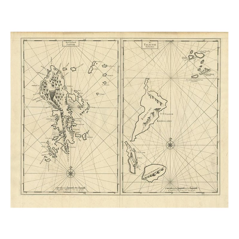
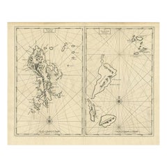
Antique Map of Sangir Island and the Talaud Islands by Valentijn, 1726
Located in Langweer, NL
Antique map titled 'Het Eyland Sangir & De Talautse Eylanden'. Two maps on one sheet. To the left, a map of Sangir Island, Indonesia. To the right, a map of the Talaud Islands, Indon...
Category
Antique 18th Century Maps
Materials
Paper
$499 Sale Price
20% Off
You May Also Like
West Coast of Africa, Guinea
Sierra Leone: An 18th Century Map by Bellin
By Jacques-Nicolas Bellin
Located in Alamo, CA
Jacques Bellin's copper-plate map entitled "Partie de la Coste de Guinee Dupuis la Riviere de Sierra Leona Jusquau Cap das Palmas", depicting the coast of Guinea and Sierra Leone in ...
Category
Antique Mid-18th Century French Maps
Materials
Paper

$460 Sale Price
20% Off
Original Antique Map of South America. C.1780
Located in St Annes, Lancashire
Great map of South America
Copper-plate engraving
Published C.1780
Two small worm holes to left side of map
Unframed.
Category
Antique Early 1800s English Georgian Maps
Materials
Paper

California, Alaska and Mexico: 18th Century Hand-Colored Map by de Vaugondy
By Didier Robert de Vaugondy
Located in Alamo, CA
This is an 18th century hand-colored map of the western portions of North America entitled "Carte de la Californie et des Pays Nord-Ouest separés de l'Asie par le détroit d'Anian, ex...
Category
Antique 1770s French Maps
Materials
Paper

Antique French Map of Asia Including China Indoneseia India, 1783
Located in Amsterdam, Noord Holland
Very nice map of Asia. 1783 Dedie au Roy.
Additional information:
Country of Manufacturing: Europe
Period: 18th century Qing (1661 - 1912)
Condition: Overall Condition B (Good Used)...
Category
Antique 18th Century European Maps
Materials
Paper

$486 Sale Price
40% Off
Dartmouth, England: A Hand-Colored 17th Century Sea Chart by Captain Collins
By Captain Greenvile Collins
Located in Alamo, CA
This hand-colored sea chart of the area around Dartmouth, England is from "Great Britain's Coasting Pilot. Being a New and Exact Survey of the Sea-Coast of England", first published ...
Category
Antique Late 17th Century English Maps
Materials
Paper

$2,220 Sale Price
20% Off
Map Of The Island Of Cuba - Guillaume Thomas Raynal (1711-1796)
Located in Porto, PT
This historical map of the Island of Cuba was produced in the late 18th century and is taken from an edition of “Atlas de toutes les parties connues du globe terrestre” by the French...
Category
Antique 18th Century Prints
Materials
Glass, Paper

More Ways To Browse
Antique Map Vietnam
Antique Maps Of Russian Empire
J C Walker Map
Massachusetts Antiques
Persian Maps
Afghanistan Antique Map
Antique Furniture Delaware
Antique Furniture Wisconsin
Antique Map By Coronelli
Antique Map Iceland
Cyprus Antique Maps
John Speed Maps
M Howard
Used Office Furniture Michigan
Antique Geological Maps
Antique Manitoba
Australian Colonial
Bengal Map