Items Similar to Original 18th-Century Map of Southern Austria, Carinthia, Carniola, and Styria


Want more images or videos?
Request additional images or videos from the seller
1 of 10
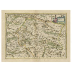
Original 18th-Century Map of Southern Austria, Carinthia, Carniola, and Styria
$957.07
£715.67
€799
CA$1,318.61
A$1,438.12
CHF 761.82
MX$17,241.07
NOK 9,702.22
SEK 8,871.96
DKK 6,088.70
About the Item
title: 18th-Century Map of Southern Austria, Carinthia, Carniola, and Styria by Robert de Vaugondy
Description: This finely engraved 18th-century map by Gilles Robert de Vaugondy showcases the southern part of the Austrian Circle, encompassing regions of modern-day Austria and Slovenia, including Styria (Steiermark), Carinthia (Kärnten), Carniola (Krain), and parts of the Istrian Peninsula. The map details topographical features, rivers, cities, and political divisions with hand-colored borders.
The Gulf of Venice (Golfe de Venise) is prominently featured to the southwest, highlighting coastal settlements. This map reflects the territorial organization under the Habsburg Monarchy during the late Holy Roman Empire, a period of significant military conflicts, including the Ottoman Wars, and economic shifts as trade routes evolved. The cartouche, elegantly decorated with floral motifs and imperial symbols, underscores the importance of these lands within the greater Austro-Hungarian sphere.
Condition: The map is in good condition, with minor signs of aging, slight discoloration in margins, and minimal foxing. The engraving remains sharp, with well-preserved hand-coloring delineating borders. Some typical wear along the edges is present but does not affect the printed area.
Framing tips: To preserve this historical piece, consider using archival-quality materials, including acid-free matting and UV-resistant glass to prevent fading. A classic gold or dark wood frame complements the map’s period aesthetic, while a wider mat border can emphasize its details. If displaying in a well-lit space, opt for museum-grade non-reflective glass to enhance clarity.
- Dimensions:Height: 20.08 in (51 cm)Width: 25.99 in (66 cm)Depth: 0.01 in (0.2 mm)
- Materials and Techniques:Paper,Engraved
- Place of Origin:
- Period:1750-1759
- Date of Manufacture:1752
- Condition:Condition: The map is in good condition, with minor signs of aging, slight discoloration in margins, and minimal foxing. The engraving remains sharp, with well-preserved hand-coloring delineating borders.
- Seller Location:Langweer, NL
- Reference Number:Seller: BG-13664-11stDibs: LU3054343868362
About the Seller
5.0
Recognized Seller
These prestigious sellers are industry leaders and represent the highest echelon for item quality and design.
Platinum Seller
Premium sellers with a 4.7+ rating and 24-hour response times
Established in 2009
1stDibs seller since 2017
2,788 sales on 1stDibs
Typical response time: <1 hour
- ShippingRetrieving quote...Shipping from: Langweer, Netherlands
- Return Policy
More From This Seller
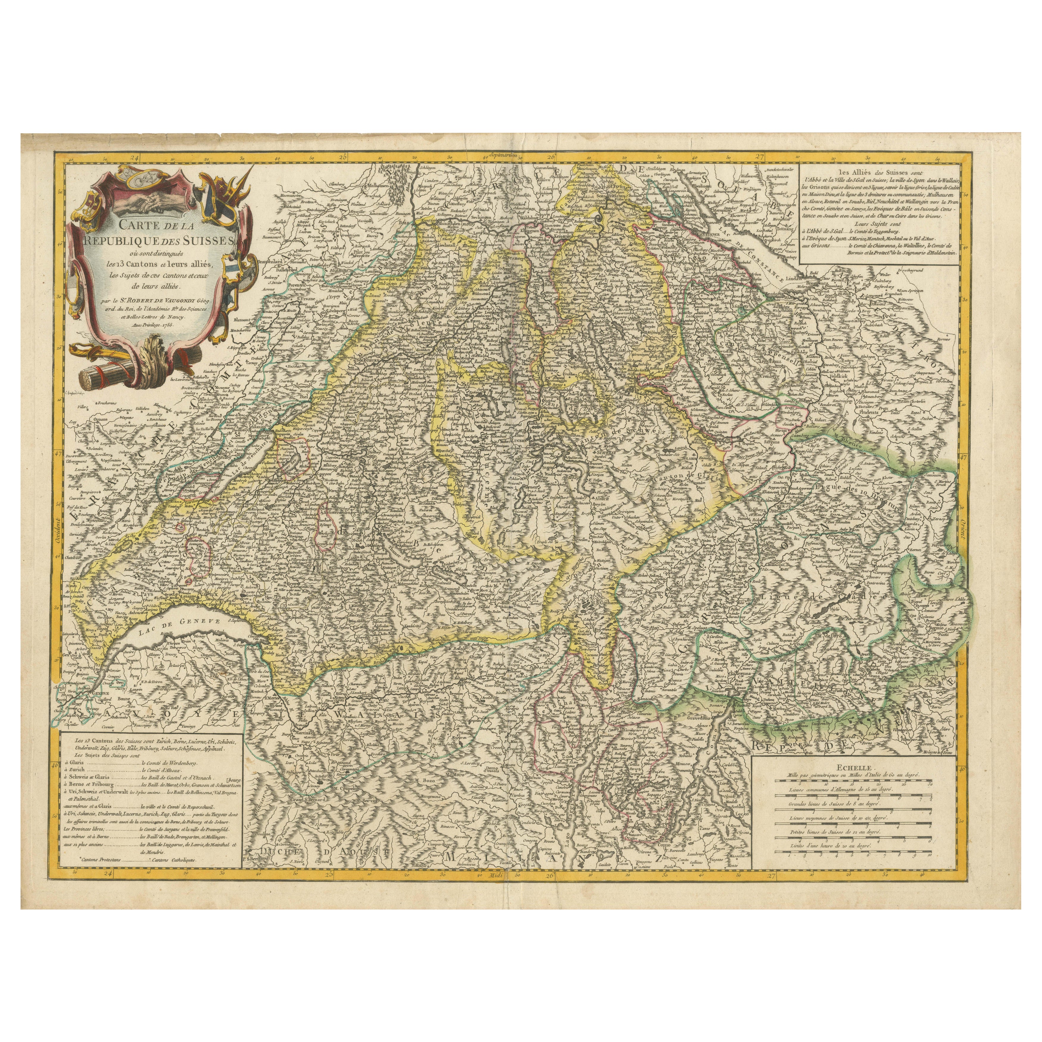
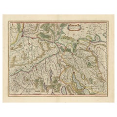
View All18th-Century Map of the Swiss Confederation by Robert de Vaugondy
Located in Langweer, NL
Title: 18th-Century Map of the Swiss Confederation by Robert de Vaugondy
Description: This detailed 18th-century map by Gilles Robert de Vaugondy presents the Swiss Confederation,...
Category
Antique 1750s Maps
Materials
Paper
Old Map of the Western Part of Central Europe, c.1680
Located in Langweer, NL
Antique map titled 'Carta nova accurate del Passagio et strada dalli Paesi Bassi'. Old map of the western portion of Central Europe. Oriented to the Northeast.
Artists and Engrav...
Category
Antique 17th Century Maps
Materials
Paper

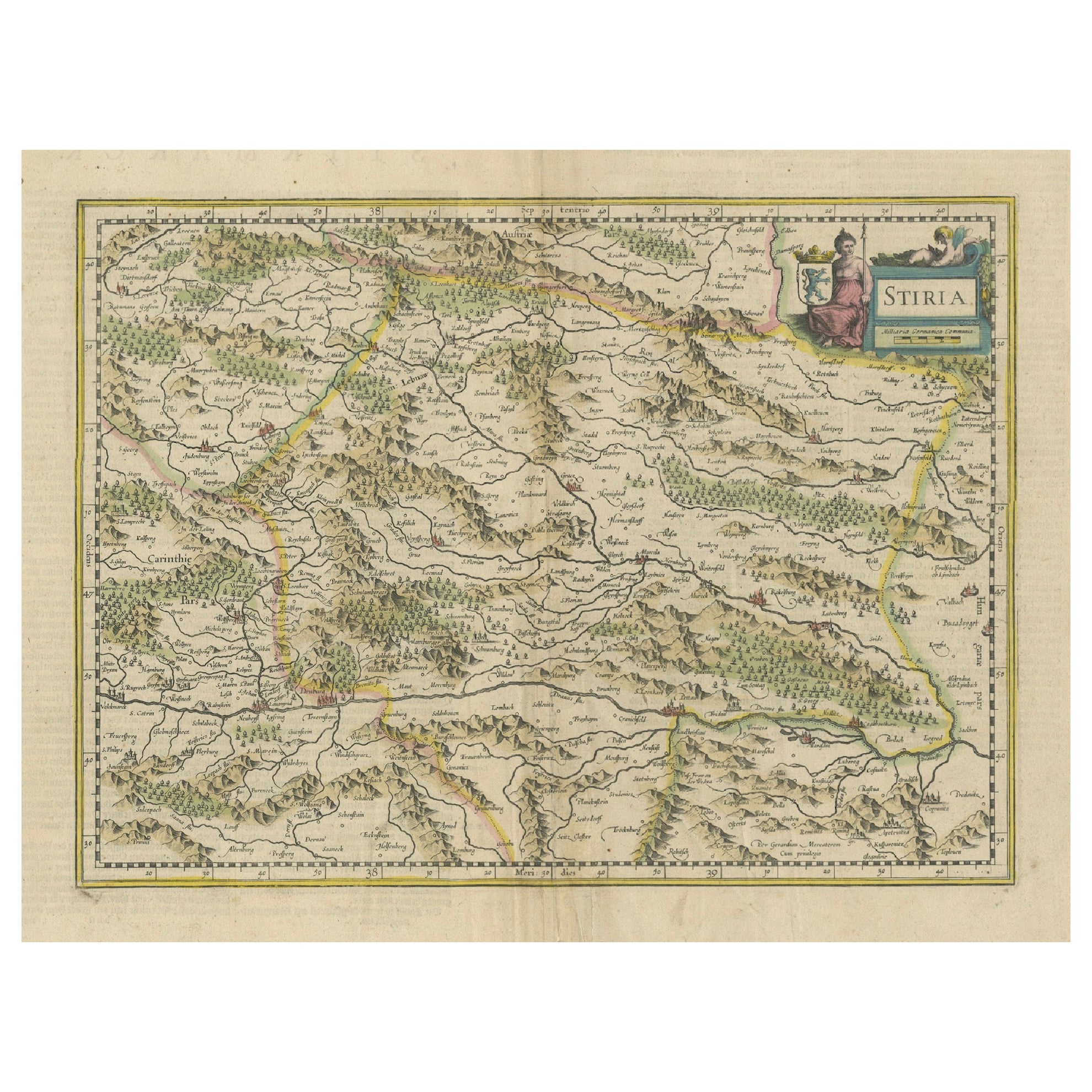
An Original Antique Mid-17th Century Blaeu Map of Styria in Southeastern Austria
Located in Langweer, NL
This is an antique map of Styria (referred to as “Stiria” or “Steyrmarck”), published by the renowned Dutch cartographer Willem Janszoon Blaeu (often simply “Blaeu”). The first editi...
Category
Antique 1640s Dutch Maps
Materials
Paper
Physical
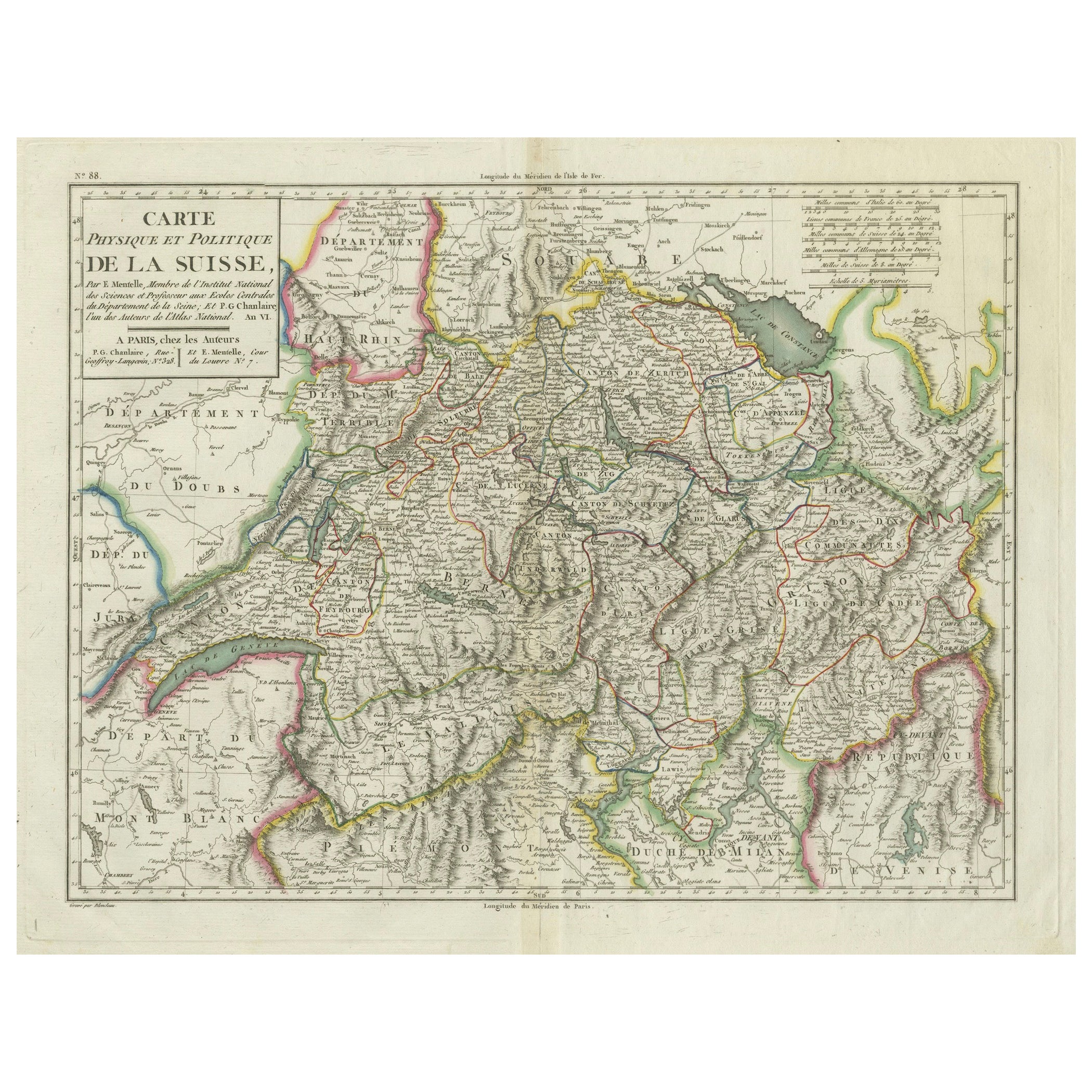
Political Map of Switzerland: Late 18th Century - Mentelle Atlas
Located in Langweer, NL
Antique Map with Title: 'Carte Physique et Politique de la Suisse'
**Publication Details:**
- **Atlas Title:** Nouvel Atlas Universel de Géographie Ancienne et Moderne
- **Purpose:...
Category
Antique 1790s Maps
Materials
Paper

$507 Sale Price
20% Off
Map of Northwestern Switzerland (Basel and Zurich Region) by Willem
Jan Blaeu
Located in Langweer, NL
Map of Northwestern Switzerland by Willem & Jan Blaeu (Circa 1650)
This is a detailed map of Northwestern Switzerland, specifically depicting the region between Basel and Zurich, cr...
Category
Antique 1650s Maps
Materials
Paper
$910 Sale Price
30% Off
Decorative Antique Map of Austria – Frederick de Wit, Amsterdam c.1690
Located in Langweer, NL
Antique Map of Austria – “Circuli Austriaci pars Septentrionalis” by F. de Wit, c.1670
This finely engraved map, titled “Circuli Austriaci pars Septent...
Category
Antique Late 17th Century Dutch Maps
Materials
Paper

You May Also Like
17th Century Nicolas Visscher Map of Southeastern Europe
Located in Hamilton, Ontario
A beautiful, highly detailed map of southeastern Europe by Nicolas Visscher. Includes regions of Northern Italy (showing the cities Bologna, Padua, and Venice), Bohemia, Austria (sho...
Category
Antique 17th Century Dutch Maps
Materials
Paper

$1,350 Sale Price
38% Off
Antique French Map of Asia Including China Indoneseia India, 1783
Located in Amsterdam, Noord Holland
Very nice map of Asia. 1783 Dedie au Roy.
Additional information:
Country of Manufacturing: Europe
Period: 18th century Qing (1661 - 1912)
Condition: Overall Condition B (Good Used)...
Category
Antique 18th Century European Maps
Materials
Paper

$486 Sale Price
40% Off
1657 Janssonius Map of Vermandois and Cappelle, Ric. A-004
Located in Norton, MA
1657 Janssonius map of
Vermandois and Cappelle
Ric.a004
Description: Antique map of France titled 'Descriptio Veromanduorum - Gouvernement de la Cappelle'. Two detailed maps o...
Category
Antique 17th Century Unknown Maps
Materials
Paper

18th Century Map of the Southern Balkans by Giovanni Maria Cassini
By Giovanni Maria Cassini
Located in Hamilton, Ontario
18th century map by Italian engraver Giovanni Maria Cassini (Italy 1745-1824).
Map of the Southern Balkans: Rome. Hand colored and copper engraved print done in the year 1788. It in...
Category
Antique 18th Century Italian Maps
Materials
Paper

$795 Sale Price
36% Off
1752 Vaugoundy Map of Flanders : Belgium, France, and the Netherlands, Ric.a002
Located in Norton, MA
Large Vaugoundy Map of Flanders:
Belgium, France, and the Netherlands
Colored -1752
Ric.a002
Description: This is a 1752 Didier Robert de Vaugondy map of Flanders. The map de...
Category
Antique 17th Century Unknown Maps
Materials
Paper

1640 Willem Blaeu Map Entitled "Contado di molise et principato vltra, " Ric.a003
By Willem Blaeu
Located in Norton, MA
1640 Willem Blaeu map entitled
"Contado di molise et principato vltra,"
Colored
Ric. a003
Measures: 38 x 49.6 cm and wide margins
DBLAEU.
Cou...
Category
Antique 17th Century Dutch Maps
Materials
Paper

More Ways To Browse
Sterling Silver Flatware Service For 12
Antique Dining Tables With Leaves
Decorative Wall Panels
Frank Lloyd Wright For Cassina
Natural Curved
Spanish Wool Rug
Leather Pouf And Ottomans
Low Side Tables
Set Of Four Italian Dining Chairs
Silk Runner Carpet
18th Century Blue And White Porcelain
3x5 Rugs
Italian Lacquer Dining Room Sets
Round Brass Table
Round Table Base
Antique Imari Porcelain
Belgian Antiques
Cream Soup