Want more images or videos?
Request additional images or videos from the seller
1 of 5
Auction endedBrowse Current Auctions
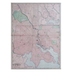
Original Antique City Plan of Louisville, Kentucky. USA. 1894
Price:$150
$195List Price
About the Item
- Creator:Rand McNally Co. (Maker)
- Dimensions:Height: 13.25 in (33.66 cm)Width: 20.5 in (52.07 cm)Depth: 0.07 in (1.78 mm)
- Materials and Techniques:Paper,Other
- Place of Origin:
- Period:
- Date of Manufacture:1894
- Condition:Wear consistent with age and use.
- Seller Location:St Annes, GB
- Reference Number:1stDibs: LU1836328810702
About the Seller
4.9
Platinum Seller
Premium sellers with a 4.7+ rating and 24-hour response times
1stDibs seller since 2016
3,261 sales on 1stDibs
Typical response time: 1 hour
Associations
International Confederation of Art and Antique Dealers
Associations
Authenticity Guarantee
In the unlikely event there’s an issue with an item’s authenticity, contact us within 1 year for a full refund. DetailsMoney-Back Guarantee
If your item is not as described, is damaged in transit, or does not arrive, contact us within 7 days for a full refund. Details24-Hour Cancellation
You have a 24-hour grace period in which to reconsider your purchase, with no questions asked.Vetted Professional Sellers
Our world-class sellers must adhere to strict standards for service and quality, maintaining the integrity of our listings.Price-Match Guarantee
If you find that a seller listed the same item for a lower price elsewhere, we’ll match it.Trusted Global Delivery
Our best-in-class carrier network provides specialized shipping options worldwide, including custom delivery.You May Also Like
Antique City View and Map of IJlst, City in Friesland, Holland, Framed, 1664
Located in Langweer, NL
Antique map titled 'Ylst'. Old map and city view of the city of IJlst, Friesland. This map originates from 'Beschrijvinge van de Heerlyckheydt van Frieslandt' by B. Schotanus à Sterr...
Category
Antique 17th Century Maps
Materials
Paper
$600
H 21.78 in W 18.59 in D 0 in
Gold Leaf Foil Pictorial Plan Map of the West Country of England Antique Style
Located in West Sussex, Pulborough
We are delighted to offer for sale this lovely Antique style pictorial plan map of the West Country of England etched in gold leaf foil
This is a very interesting and decorative p...
Category
20th Century English Adam Style Maps
Materials
Gold Leaf

$378
H 15.95 in W 20.08 in D 0.4 in
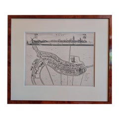
Antique Plan of the City of Bayonne, France
Located in Langweer, NL
Antique map titled 'Plan de Bayonne'. Original old plan of the city of Bayonne, France. This map originates from 'Le Petit Atlas Maritime (..)' by J.N. Bellin. Published 1764.
Be...
Category
Antique Mid-18th Century Maps
Materials
Paper
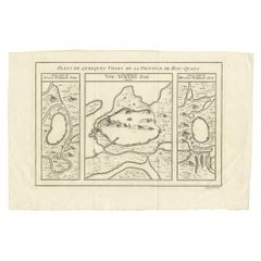
Antique Map of Three Cities of China
s Hubei and Hunan Provinces by Bellin, 1755
By Jacques-Nicolas Bellin
Located in Langweer, NL
Antique print titled 'Plans de Quelques villes de la province de Hou-Quang.'
Three bird's-eye view plans of walled cities in what are now China's Hubei (Hou-Quang) and Hunan Provin...
Category
Antique Mid-18th Century French Maps
Materials
Paper
$198
H 10.04 in W 15.36 in D 0.02 in
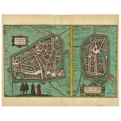
Antique Map of The Frisian Cities Leeuwarden and Franeker in Friesland, 1580
Located in Langweer, NL
Antique map titled 'Lewardum Occidentlis Frisiae Opp: 1580, Franicher Nobiliu hominum, in Frisia Occidentali, ut plurimum saedes'.
This sheet contains two very detailed bird?s-ey...
Category
Antique 16th Century Maps
Materials
Paper
$780
H 19.69 in W 15.36 in D 0 in
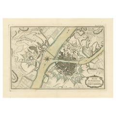
Detailed Original Antique Plan of the City and Fort of Malacca, Malaysia, 1764
Located in Langweer, NL
Description: Antique map titled 'Plan de la Ville et Forteresse de Malaca'. Detailed plan of the city and fort of Malacca on the southern Malay Peninsula, commanding the strategic st...
Category
Antique 1760s Maps
Materials
Paper
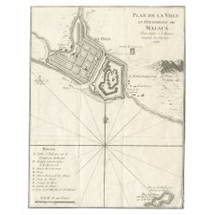
$228
H 7.88 in W 5.91 in D 0 in
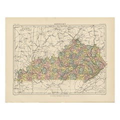
Antique Map of Kentucky
Located in Langweer, NL
Antique map titled 'Kentucky'. Original antique map of Kentucky, United States. This print originates from 'Encyclopaedia Britannica', Ninth E...
Category
Antique Late 19th Century Maps
Materials
Paper
Original Antique Engraving of the Eastern Hemisphere, c.1700
Located in Langweer, NL
Antique map titled 'Proiectio Optica Aequinoctia lis Hemishaerii Orientalis' - Map of the Eastern Hemisphere with Africa, Europe, Asia and Nova Hollandia...
Category
Antique 17th Century Maps
Materials
Paper
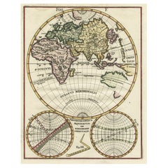
$884 Sale Price
20% Off
H 10.63 in W 8.47 in D 0 in
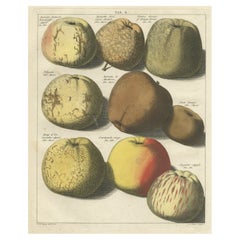
Original Antique Hand-Colored Print of Various Apples, 1758
Located in Langweer, NL
Antique print depicting apple variaties including Witte Kruid-Appel, Rode Somer-Calville, Rode Jopen, Witte Somer-Calville, Somer Citroen Appel, Somer Kroon, Engelse Carolyn, Roos-Ap...
Category
Antique 18th Century Maps
Materials
Paper
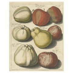
$307 Sale Price
20% Off
H 13.12 in W 9.45 in D 0 in
Original Hand-Colored Antique Print of Various Apples, 1758
Located in Langweer, NL
Antique print depicting apple variaties including the Borsdorsser Appel, Goud-Reinet, Krappe-Kruin, Nelguin, Reinette de Montbron, Caracter Appel, Soete Veentje, Courtpendu Rouge, An...
Category
Antique 18th Century Maps
Materials
Paper
$307 Sale Price
20% Off
H 13.78 in W 9.85 in D 0 in
More From This Seller
View AllOriginal Antique City Plan of Kansas City, USA. 1894
By Rand McNally
Co.
Located in St Annes, Lancashire
Fabulous colorful map of Kansas City
Original color
By Rand, McNally & Co.
Published, 1894
Unframed
Slightly reduced bottom margin.
Free shipping.
Category
Antique 1890s American Maps
Materials
Paper

Large Original Antique City Plan of Baltimore, USA, 1894
By Rand McNally
Co.
Located in St Annes, Lancashire
Fabulous colorful map of Baltimore
Original color
By Rand, McNally & Co.
Published, 1894
Unframed
Free shipping.
Category
Antique 1890s American Maps
Materials
Paper
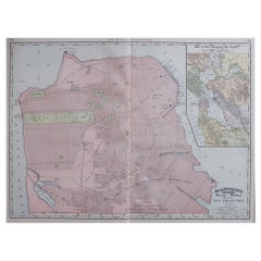
Large Original Antique City Plan of San Francisco, USA, 1894
By Rand McNally
Co.
Located in St Annes, Lancashire
Fabulous colorful map of San Francisco
Original color
By Rand, McNally & Co.
Published, 1894
Unframed
Free shipping.
Category
Antique 1890s American Maps
Materials
Paper
Large Original Antique City Plan of Philadelphia, USA, circa 1900
By Rand McNally
Co.
Located in St Annes, Lancashire
Fabulous colorful map of Philadelphia
Original color
By Rand, McNally & Co.
Published, circa 1900.
Unframed
Free shipping.
Category
Antique Early 1900s American Maps
Materials
Paper

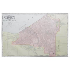
Original Antique City Plan of Cleveland, Ohio, USA, circa 1900
By Rand McNally
Co.
Located in St Annes, Lancashire
Fabulous colorful map of Cleveland
Original color
By Rand, McNally & Co.
Published, circa 1900
Unframed
Free shipping.
Category
Antique 1890s American Maps
Materials
Paper
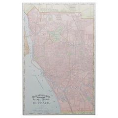
Original Antique City Plan of Buffalo, New York, USA, circa 1900
By Rand McNally
Co.
Located in St Annes, Lancashire
Fabulous colorful map of Buffalo
Original color
By Rand, McNally & Co.
Published, circa 1900
Unframed
Minor edge tears
Free shipping.
Category
Antique 1890s American Maps
Materials
Paper
Still Thinking About These?
All Recently ViewedMore Ways To Browse
Kentucky Furniture
Kentucky Antiques
Louisville Used Office Furniture
Antique Maps Of Long Island
Calcutta Map
Gibraltar Antique Map
Guyana Antique Map
Maps Of New Mexico
Saudi Arabia Map
16th Century Scotland
Antique Leather Map
Antique Map Of Argentina
Antique Map Of Colombia
Cornwall Map
Early Texas Furniture
Iraq Map
James Cook Map
Kentucky Antiques