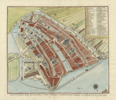
Items Similar to Original Antique Map or City Plan of Amsterdam, Netherlands. Circa 1835
Want more images or videos?
Request additional images or videos from the seller
1 of 5
Original Antique Map or City Plan of Amsterdam, Netherlands. Circa 1835
$60
£45.47
€52.40
CA$84.86
A$91.26
CHF 48.79
MX$1,100.52
NOK 617.04
SEK 562.21
DKK 391.51
About the Item
Nice map of Amsterdam
Drawn and engraved by J.Dower
Published by Orr
Smith. C.1835
Unframed.
Free shipping
- Dimensions:Height: 9.25 in (23.5 cm)Width: 12.25 in (31.12 cm)Depth: 0.07 in (1.78 mm)
- Materials and Techniques:Paper,Other
- Place of Origin:
- Period:
- Date of Manufacture:1837
- Condition:Wear consistent with age and use.
- Seller Location:St Annes, GB
- Reference Number:1stDibs: LU1836345684452
About the Seller
4.9
Gold Seller
Premium sellers maintaining a 4.3+ rating and 24-hour response times
1stDibs seller since 2016
3,270 sales on 1stDibs
Typical response time: 1 hour
Associations
International Confederation of Art and Antique Dealers
Associations
- ShippingRetrieving quote...Shipping from: St Annes, United Kingdom
- Return Policy
More From This Seller
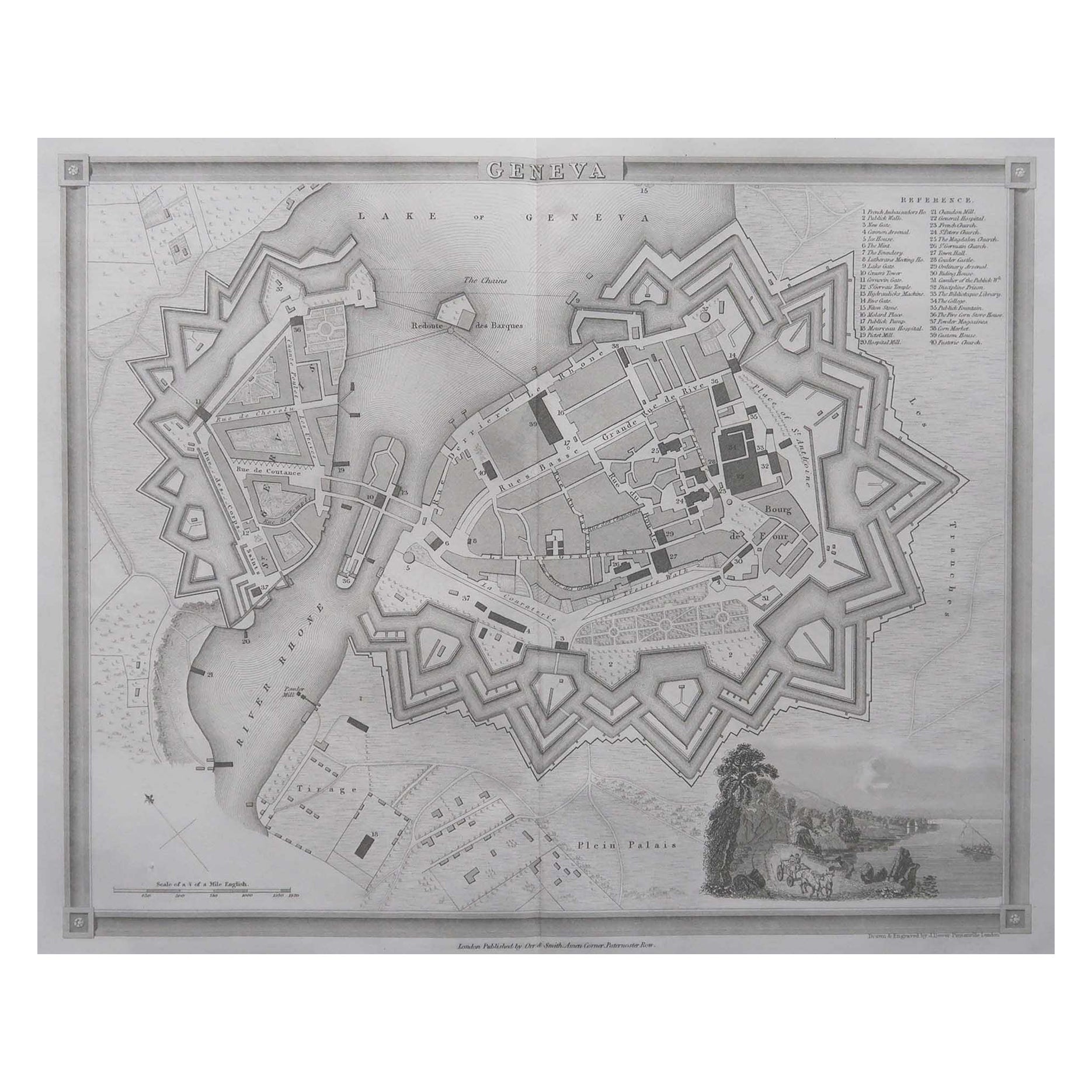
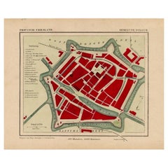
View AllOriginal Antique Map or City Plan of Geneva, Switzerland. Circa 1835
Located in St Annes, Lancashire
Nice map of Geneva
Drawn and engraved by J.Dower
Published by Orr & Smith. C.1835
Unframed.
Free shipping
Category
Antique 1830s English Maps
Materials
Paper

Original Antique Map or City Plan of Rome, Italy. Circa 1835
Located in St Annes, Lancashire
Nice map of Rome
Drawn and engraved by J.Dower
Published by Orr & Smith. C.1835
Unframed.
Free shipping
Category
Antique 1830s English Maps
Materials
Paper

Original Antique Map or City Plan of Venice, Italy. Circa 1835
Located in St Annes, Lancashire
Nice map of Venice
Drawn and engraved by J.Dower
Published by Orr & Smith. C.1835
Unframed.
Free shipping
Category
Antique 1830s English Maps
Materials
Paper

Original Antique Map or City Plan of Madrid, Spain. Circa 1835
Located in St Annes, Lancashire
Nice map of Madrid
Drawn and engraved by J.Dower
Published by Orr & Smith. C.1835
Unframed.
Free shipping
Category
Antique 1830s English Maps
Materials
Paper

Original Antique Map or City Plan of Istanbul, Turkey. Circa 1835
Located in St Annes, Lancashire
Nice map of Istanbul
Drawn and engraved by J.Dower
Published by Orr & Smith. C.1835
Unframed.
Free shipping
Category
Antique 1830s English Maps
Materials
Paper
Large Original Antique Folding Map of Manchester, England, Dated 1793
Located in St Annes, Lancashire
Superb map of Manchester and Salford
Folding map. Printed on paper laid on to the original canvas
Unframed.
Published by C. Laurent, 1793.
Free shippi...
Category
Antique 1790s English Georgian Maps
Materials
Canvas, Paper

You May Also Like
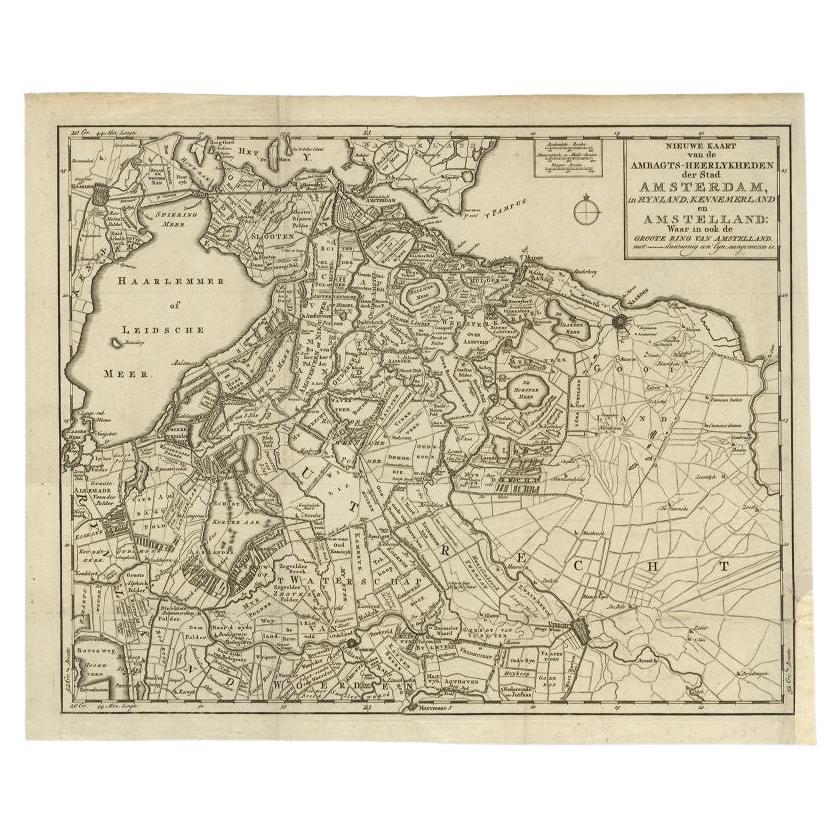
Antique Map of the Region of Amsterdam by Wagenaar, c.1760
Located in Langweer, NL
Antique map titled 'Nieuwe Kaart van de Ambagts - Heerlykheden der Stad Amsterdam, in Rynland, Kennemerland en Amstelland (..).' Detailed map of the administrative territories in the...
Category
Antique 18th Century Maps
Materials
Paper
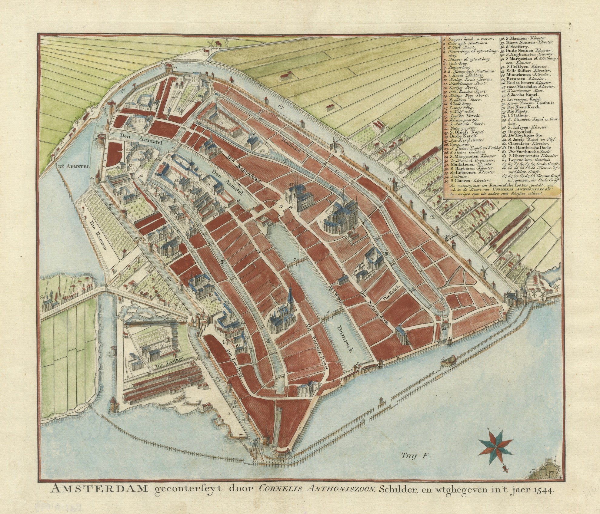
Handcoloured Engraved Map of Amsterdam, Published in ca.1760
Located in Langweer, NL
This original antique map titled "AMSTERDAM geconterfeyt door CORNELIS ANTHONISZOON, Schilder, en wtghegeven in't jaer 1544" is a handcolored engraved map, published by Jan Wagenaar ...
Category
Antique 1760s Maps
Materials
Paper
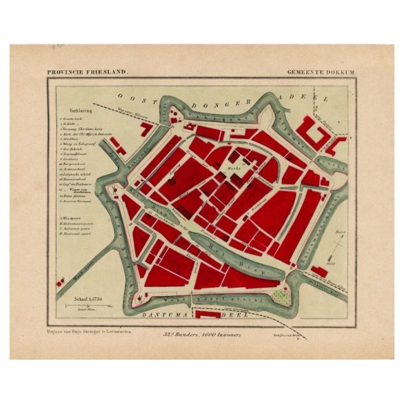
Antique Map of Dokkum a City in the North of Friesland, the Netherlands, 1868
Located in Langweer, NL
Antique map titled 'Provincie Friesland - Gemeente Dokkum'. Map of the township of Dokkum, Friesland. This map originates from 'Gemeente-Atlas van Nederland' by J. Kuyper.
The best-known event in Dokkum's history is the martyrdom of the Anglo-Saxon missionary Saint Boniface (Dutch: Bonifatius) in 754. Oliver of Cologne preached the Fifth Crusade in Dokkum in 1214 and Dokkum sent a contingent; the crescent in the coat of arms of Dokkum refers to this event. Dokkum acquired city rights in 1298. In 1572 Dokkum was sacked by the Spaniards after it had joined the Dutch Revolt...
Category
Antique 19th Century Maps
Materials
Paper
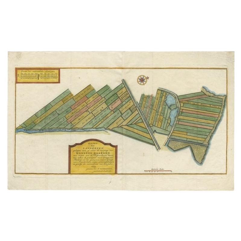
Antique Map of Estates of The Year 1669 in Amsterdam, Published c.1767
Located in Langweer, NL
Antique map titled 'Kaart der Landerijen, gelegen aan of onder de rooyinge der honderd gaarden (..)'. Map showing estates in Amsterdam in 1669. Published by Yntema and Tieboel, 1767....
Category
Antique 18th Century Maps
Materials
Paper

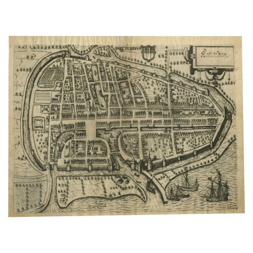
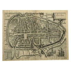
Antique Map of the City of Rotterdam by Guicciardini, C.1600
Located in Langweer, NL
Antique map titled 'Rotterdam'. Bird's eye view plan of Rotterdam in the province of Zuid-Holland, The Netherlands, Holland. This map originates from one of the editions of 'Discritt...
Category
Antique 17th Century Maps
Materials
Paper
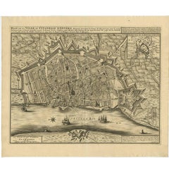
Antique Map of the City of Antwerpen ‘Belgium’ by A. Deur, 1729
Located in Langweer, NL
Copper-engraving by A. Deur. Published by I. van der Kloot in Den Haag, 1729. With French and Dutch title-cartouches and explanatory notes, several ships o...
Category
Antique Early 18th Century Maps
Materials
Paper
$733 Sale Price
20% Off
More Ways To Browse
China Silk Rug
Chrome Glass Coffee Tables
Antique Italian Chairs
Beni Ourain Rugs
French Iron And Glass Table
Glass Top Wood Base Coffee Tables
T Chair
Antique Silver Basket
Antique Walkers
Ebony Wood Furniture
Opalescent Glass
Pair Of Danish Chairs
Veneer Dining Tables
1970 Italian Armchair
Furniture Uk
House Of Denmark Table And Chairs
Louis Marble Top Side Table
Antique Russian Rugs