Items Similar to Original Antique Map of England and Wales from the 1909 Royal Atlas


Want more images or videos?
Request additional images or videos from the seller
1 of 5
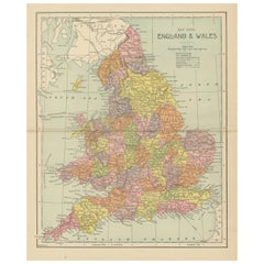
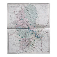
Original Antique Map of England and Wales from the 1909 Royal Atlas
$239.38
$299.2320% Off
£177.87
£222.3420% Off
€200
€25020% Off
CA$327.91
CA$409.8820% Off
A$357.73
A$447.1620% Off
CHF 189.73
CHF 237.1720% Off
MX$4,309.83
MX$5,387.2920% Off
NOK 2,408.07
NOK 3,010.0920% Off
SEK 2,204.65
SEK 2,755.8220% Off
DKK 1,523.57
DKK 1,904.4720% Off
About the Item
The antique map titled 'England and Wales' is a historical cartographic representation of these two nations. This original antique map of England and Wales is sourced from the 'Royal Atlas of Modern Geography,' which was published by W.
A.K. Johnston in the year 1909.
**Key Aspects of the Map:**
1. **Geographical Coverage**: The map provides a comprehensive view of the geography and topography of England and Wales, two distinct countries within the United Kingdom. It includes details of cities, towns, rivers, mountains, and coastlines.
2. **Historical Context**: Published in 1909, this map reflects the political and geographical landscape of England and Wales during the early 20th century. It is a valuable reference for understanding the boundaries and administrative divisions of the time.
3. **Publisher**: The 'Royal Atlas of Modern Geography' by W.
A.K. Johnston was known for its accuracy and detail. Maps from this atlas are esteemed for their cartographic quality.
4. **Educational Value**: Antique maps like this one are valuable educational tools, offering historical insights into the geography, cartography, and political divisions of the era.
5. **Cartographic Style**: The map's cartographic style adheres to the standards of mapmaking in the early 20th century, with a focus on precision and clarity. It likely includes a legend to help interpret the map's symbols and features.
6. **Administrative Boundaries**: The map may depict county boundaries, administrative regions, and major transportation routes, providing a comprehensive view of the political and logistical structure of England and Wales.
7. **Historical Place Names**: Antique maps often feature historical place names, shedding light on the nomenclature and historical significance of various locations.
8. **Geographical Features**: Details such as mountain ranges, rivers, lakes, and coastal features are likely included, offering a comprehensive view of the natural landmarks of the region.
Overall, the 'England and Wales' antique map is a valuable historical document, providing insights into the geographical and political characteristics of these two nations within the United Kingdom during the early 20th century. It serves as a valuable resource for historians, geographers, and those interested in the history and geography of England and Wales.
- Dimensions:Height: 19.49 in (49.5 cm)Width: 24.41 in (62 cm)Depth: 0.02 in (0.5 mm)
- Materials and Techniques:
- Period:
- Date of Manufacture:1909
- Condition:Minor fading. General age-related toning, some foxing. Please study image carefully.
- Seller Location:Langweer, NL
- Reference Number:Seller: BG-12940-51stDibs: LU3054324702522
About the Seller
5.0
Recognized Seller
These prestigious sellers are industry leaders and represent the highest echelon for item quality and design.
Platinum Seller
Premium sellers with a 4.7+ rating and 24-hour response times
Established in 2009
1stDibs seller since 2017
2,820 sales on 1stDibs
Typical response time: 1 hour
- ShippingRetrieving quote...Shipping from: Langweer, Netherlands
- Return Policy
More From This Seller
View AllAntique Map of, Northern England and Wales by Johnston, 1882
Located in Langweer, NL
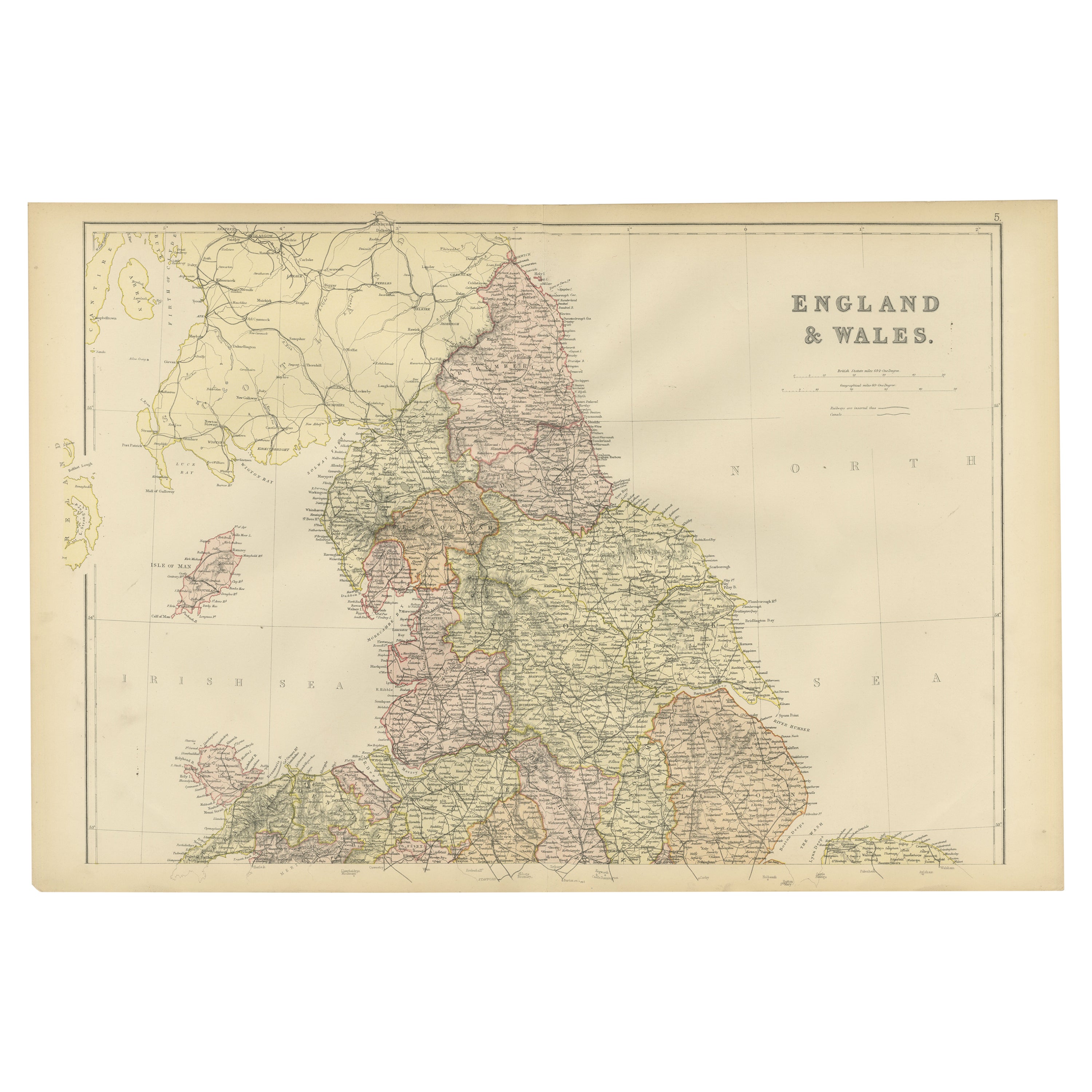
Antique map titled 'England and Wales'.
Old map of England and Wales. This map originates from 'The Royal Atlas of Modern Geography, Exhibiting, in a Series of Entirely Original an...
Category
Antique 19th Century Maps
Materials
Paper

Antique Map of England and Wales
North
by A.K. Johnston, 1865
Located in Langweer, NL
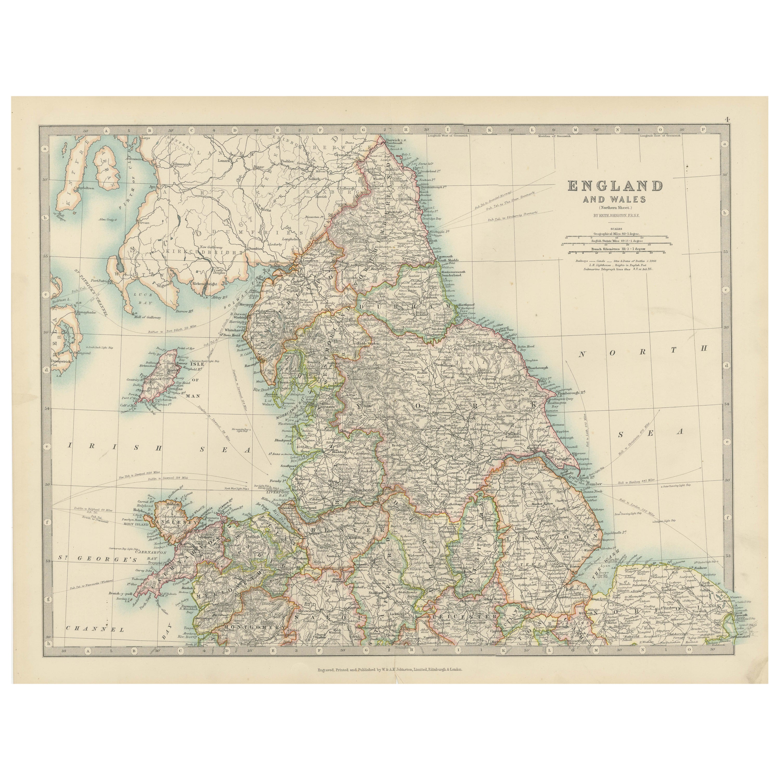
Antique map titled 'England and Wales (Northern Sheet)'. This map originates from the ‘Royal Atlas of Modern Geography’ by Alexander Keith Johnston. Published by William Blackwood an...
Category
Antique Mid-19th Century Scottish Maps
Materials
Paper

Lithographed Antique Map of England and Wales
Located in Langweer, NL
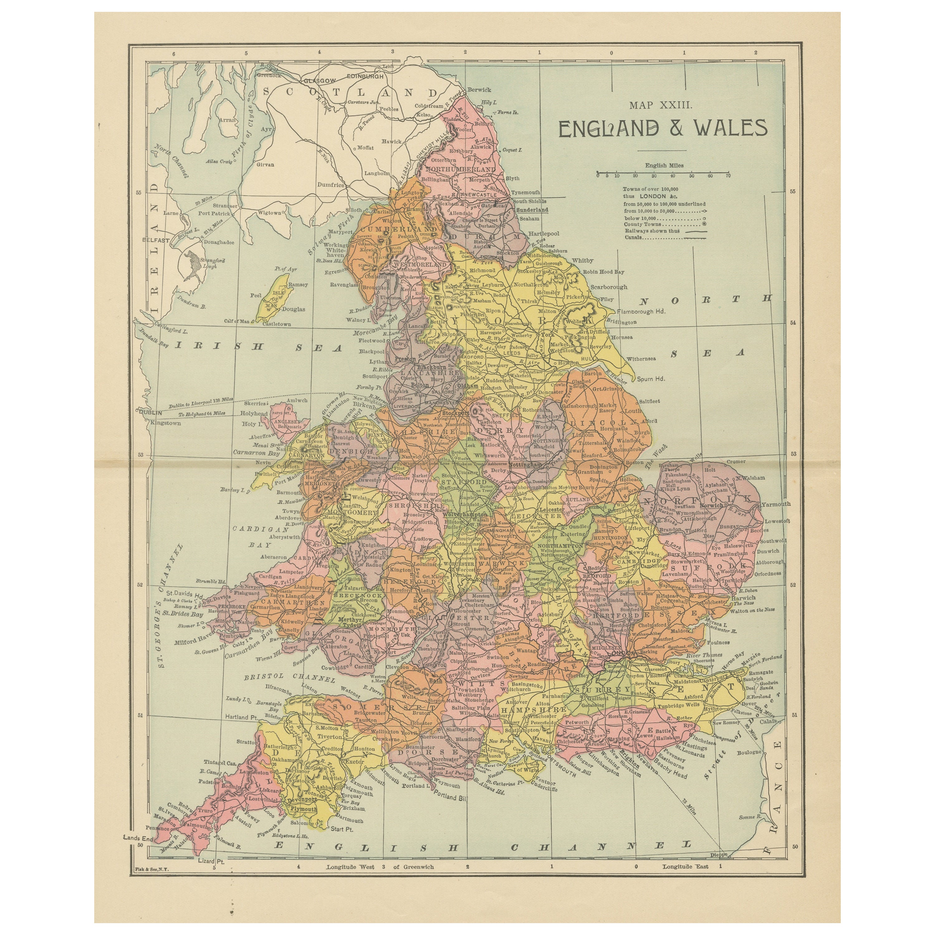
Original antique map titled 'Map XXIII England & Wales'. Lithographed map of England and Wales. Published by Fisk & See, circa 1890.
Category
Antique Late 19th Century Maps
Materials
Paper
$181 Sale Price
20% Off
Antique Map of England and Wales, 1903, with Detailed Counties and Railways
Located in Langweer, NL
Title: Antique Map of England and Wales, 1903, with Detailed Counties and Railways
Description:
This beautifully detailed antique map, titled "England and Wales," was engraved and p...
Category
Early 20th Century Maps
Materials
Paper
Colorful Detailed Antique Map of England and Wales, 1882
Located in Langweer, NL
Explore the Historic Splendor of 'England and Wales' with this Antique Map! Part of a distinguished collection, this map presents a captivating view of the enchanting landscapes, cit...
Category
Antique 1880s Maps
Materials
Paper
$162 Sale Price
20% Off
Antique Folding Map of England and Wales
Located in Langweer, NL
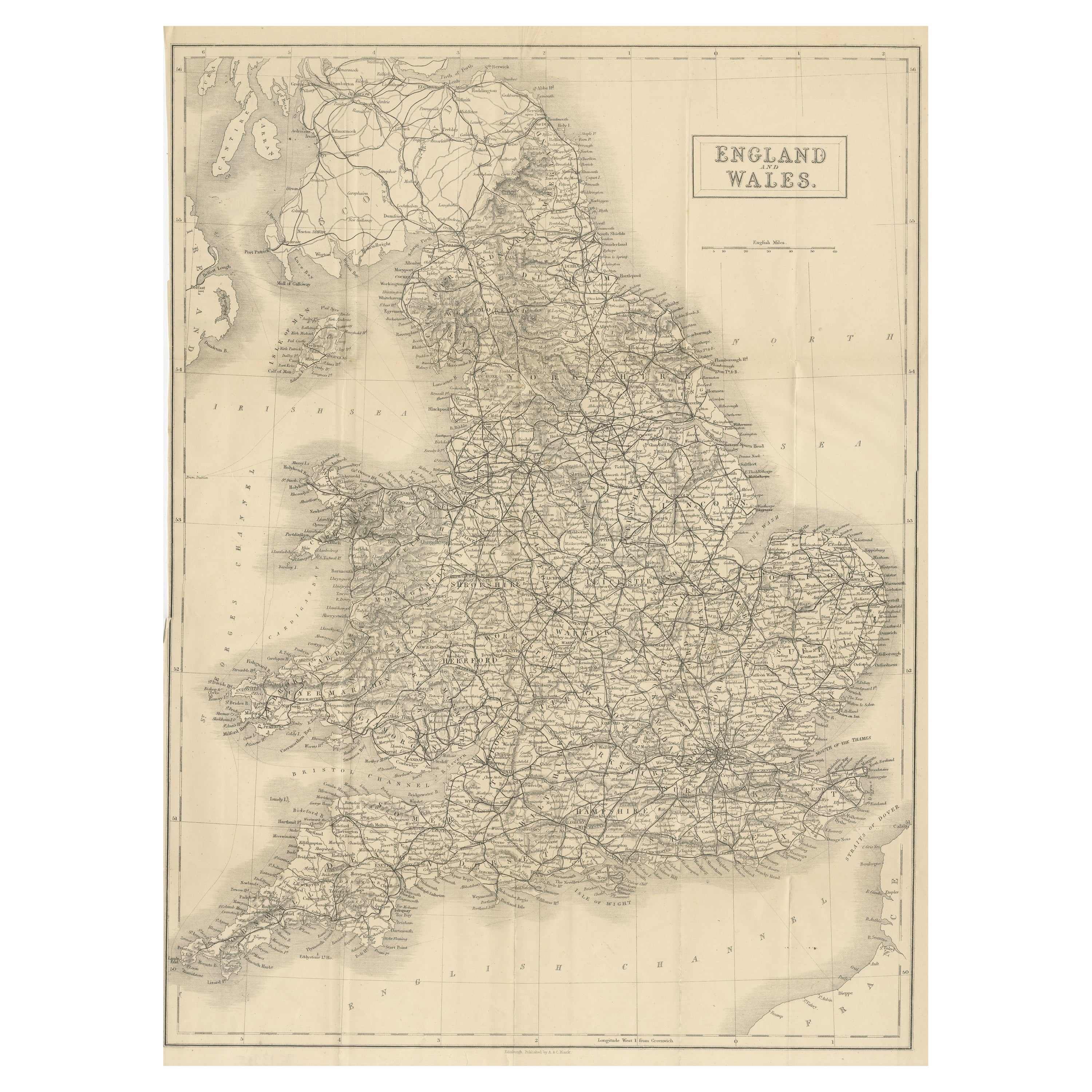
Antique map titled 'England and Wales'. Original folding map of England and Wales. Publishes by A. & C. Black, circa 1890.
Category
Antique Late 19th Century Maps
Materials
Paper
$402 Sale Price
20% Off
You May Also Like
England and Wales, Northern Part. Century Atlas antique vintage map
Located in Melbourne, Victoria
'The Century Atlas. England and Wales, Northern Part'
Original antique map, 1903.
Central fold as issued. Map name and number printed on the reverse corners.
Sheet 29.5cm by 40cm.
Category
Early 20th Century Victorian More Prints
Materials
Lithograph

Large Original Vintage Map of the United Kingdom, circa 1920
Located in St Annes, Lancashire
Great map of The United Kingdom
Unframed
Original color
By John Bartholomew and Co. Edinburgh Geographical Institute
Published, circa 1920
Free shipping.
Category
Vintage 1920s British Maps
Materials
Paper

England, Scotland
Ireland: A Hand Colored Map of Great Britain by Tirion
By Isaak Tirion
Located in Alamo, CA
This is a hand-colored double page copperplate map of Great Britain entitled "Nieuwe Kaart van de Eilanden van Groot Brittannien Behelzende de Kon...
Category
Antique Mid-18th Century Dutch Maps
Materials
Paper

$700 Sale Price
20% Off
Original Antique English County Map, Derbyshire, J
C Walker, 1851
Located in St Annes, Lancashire
Great map of Derbyshire
Original colour
By J & C Walker
Published by Longman, Rees, Orme, Brown & Co. 1851
Unframed.
Category
Antique 1850s English Other Maps
Materials
Paper

Original Antique English County Map, Staffordshire, J
C Walker, 1851
Located in St Annes, Lancashire
Great map of Staffordshire
Original colour
By J & C Walker
Published by Longman, Rees, Orme, Brown & Co. 1851
Unframed.
Category
Antique 1850s English Other Maps
Materials
Paper
Antique Lithography Map, Derbyshire, English, Framed Cartography, Victorian
Located in Hele, Devon, GB
This is an antique lithography map of Derbyshire. An English, framed atlas engraving of cartographic interest, dating to the mid 19th century and later.
Superb lithography of Derby...
Category
Antique Mid-19th Century British Victorian Maps
Materials
Glass, Wood, Paper

More Ways To Browse
Antique Maps Persia
Migeon Migeon
Antique Maps Of Canada
Map Of Arabia
Caribbean Map
California Map
Map Of Egypt
Antique Ecuador
Antique Map New York
Nautical Maps
18th Century Maps America
Antique Map Of Egypt
Map Of Austria
New Zealand Map
Antique Linen Map
19th Century World Map
Antique Ohio Maps
Antique Texas Furniture