Items Similar to Original Antique Map of Hungary, Arrowsmith, 1820

Want more images or videos?
Request additional images or videos from the seller
1 of 5
Original Antique Map of Hungary, Arrowsmith, 1820
$35
£26.63
€30.68
CA$49.69
A$53.31
CHF 28.59
MX$641.81
NOK 360.45
SEK 328.68
DKK 229.24
About the Item
Great map of Hungary
Drawn under the direction of Arrowsmith.
Copper-plate engraving.
Published by Longman, Hurst, Rees, Orme and Brown, 1820
Unframed.
- Dimensions:Height: 10.5 in (26.67 cm)Width: 16 in (40.64 cm)Depth: 0.07 in (1.78 mm)
- Materials and Techniques:Paper,Other
- Place of Origin:
- Period:
- Date of Manufacture:1820
- Condition:Wear consistent with age and use.
- Seller Location:St Annes, GB
- Reference Number:1stDibs: LU1836331233192
About the Seller
4.9
Gold Seller
Premium sellers maintaining a 4.3+ rating and 24-hour response times
1stDibs seller since 2016
3,276 sales on 1stDibs
Typical response time: 1 hour
Associations
International Confederation of Art and Antique Dealers
Associations
- ShippingRetrieving quote...Shipping from: St Annes, United Kingdom
- Return Policy
More From This Seller
View AllOriginal Antique Map of Europe, Arrowsmith, 1820
Located in St Annes, Lancashire
Great map of Europe
Drawn under the direction of Arrowsmith.
Copper-plate engraving.
Published by Longman, Hurst, Rees, Orme and Brown, 1820
...
Category
Antique 1820s English Maps
Materials
Paper

Large Original Antique Map of Poland by Sidney Hall, 1847
Located in St Annes, Lancashire
Great map of Poland
Drawn and engraved by Sidney Hall
Steel engraving
Original colour outline
Published by A & C Black. 1847
Unframed
...
Category
Antique 1840s Scottish Maps
Materials
Paper

Original Antique Map of South America. C.1780
Located in St Annes, Lancashire
Great map of South America
Copper-plate engraving
Published C.1780
Two small worm holes to left side of map
Unframed.
Category
Antique Early 1800s English Georgian Maps
Materials
Paper

Original Antique Map of Ancient Greece, Achaia, Corinth, 1786
Located in St Annes, Lancashire
Great map of Ancient Greece. Showing the region of Thessaly, including Mount Olympus
Drawn by J.D. Barbie Du Bocage
Copper plate engraving by P.F Tardieu
Original hand color...
Category
Antique 1780s French Other Maps
Materials
Paper

Original Antique Map of Ancient Greece- Boeotia, Thebes, 1787
Located in St Annes, Lancashire
Great map of Ancient Greece. Showing the region of Boeotia, including Thebes
Drawn by J.D. Barbie Du Bocage
Copper plate engraving by P.F T...
Category
Antique 1780s French Other Maps
Materials
Paper

Large Original Antique Map of Lombardy and Venice, Italy. John Dower, 1861
Located in St Annes, Lancashire
Great map of Lombardy and Venice
Lithograph engraving by John Dower
Original colour
Published, 1861
Unframed
Good condition / crease to bottom left corner
Free shipping
Category
Antique 1860s English Victorian Maps
Materials
Paper

You May Also Like
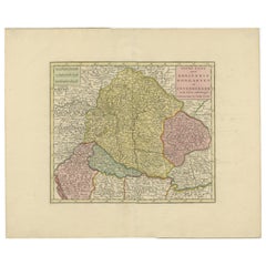
Antique Map of the Kingdom of Hungary by Keizer
de Lat, 1788
Located in Langweer, NL
Antique map titled 't Koninkryk Hongarien (..)'. Uncommon original antique map of the Kingdom of Hungary. This map originates from 'Nieuwe Natuur- Geschied- en Handelkundige Zak- en ...
Category
Antique Late 18th Century Maps
Materials
Paper

$332 Sale Price
20% Off
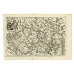
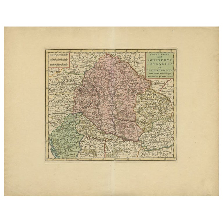
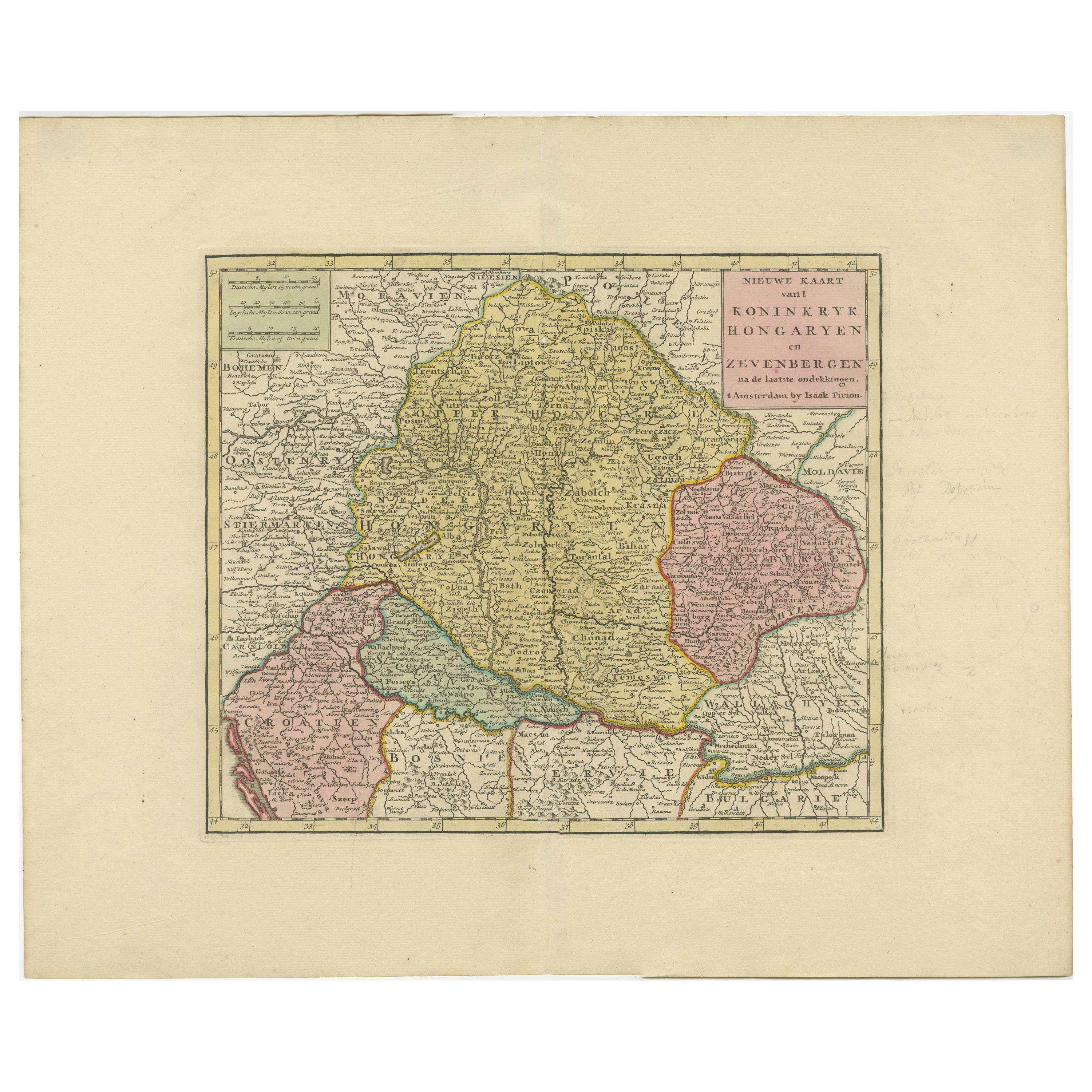
Antique Map of Hungary Incl Surroundings like Croatia, Bosnia, Servia, 1730
Located in Langweer, NL
Antique map titled 'Nieuwe Kaart van t Koninkryk Hongaryen en Zevenbergen na de laatste ontdekkingen'.
This map depicts Hungary including surroundings like Croatia, Bosnia, Servia,...
Category
Antique 18th Century Maps
Materials
Paper

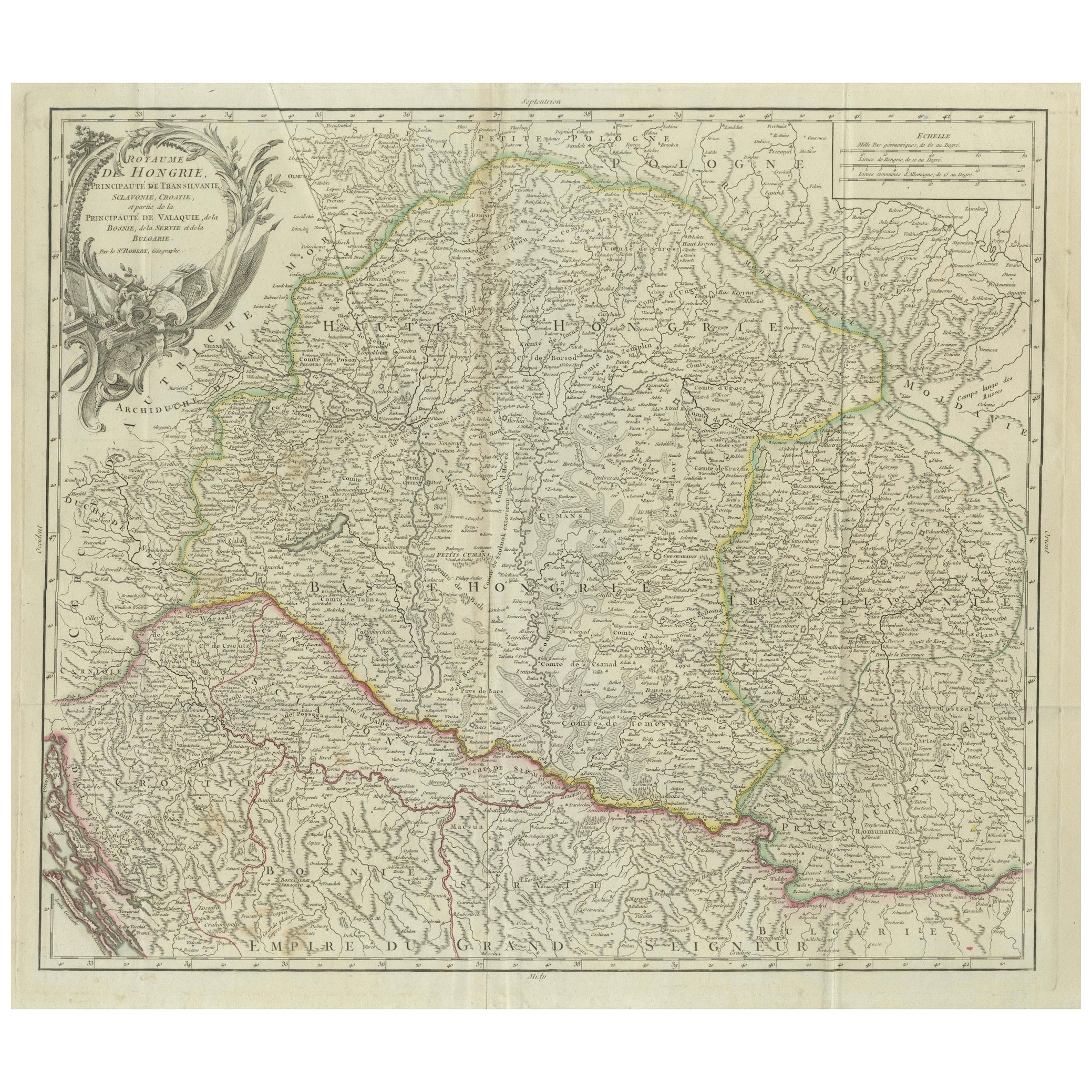
Antique Map of the Kingdom of Hungary and Transylvania, circa 1780
Located in Langweer, NL
Antique Map of the Kingdom of Hungary and Surrounding Regions by S. Robert, circa 1780
This beautifully engraved map titled Royaume de Hongrie, Principauté de Transilvanie, Esclavon...
Category
Antique Late 18th Century French Maps
Materials
Paper

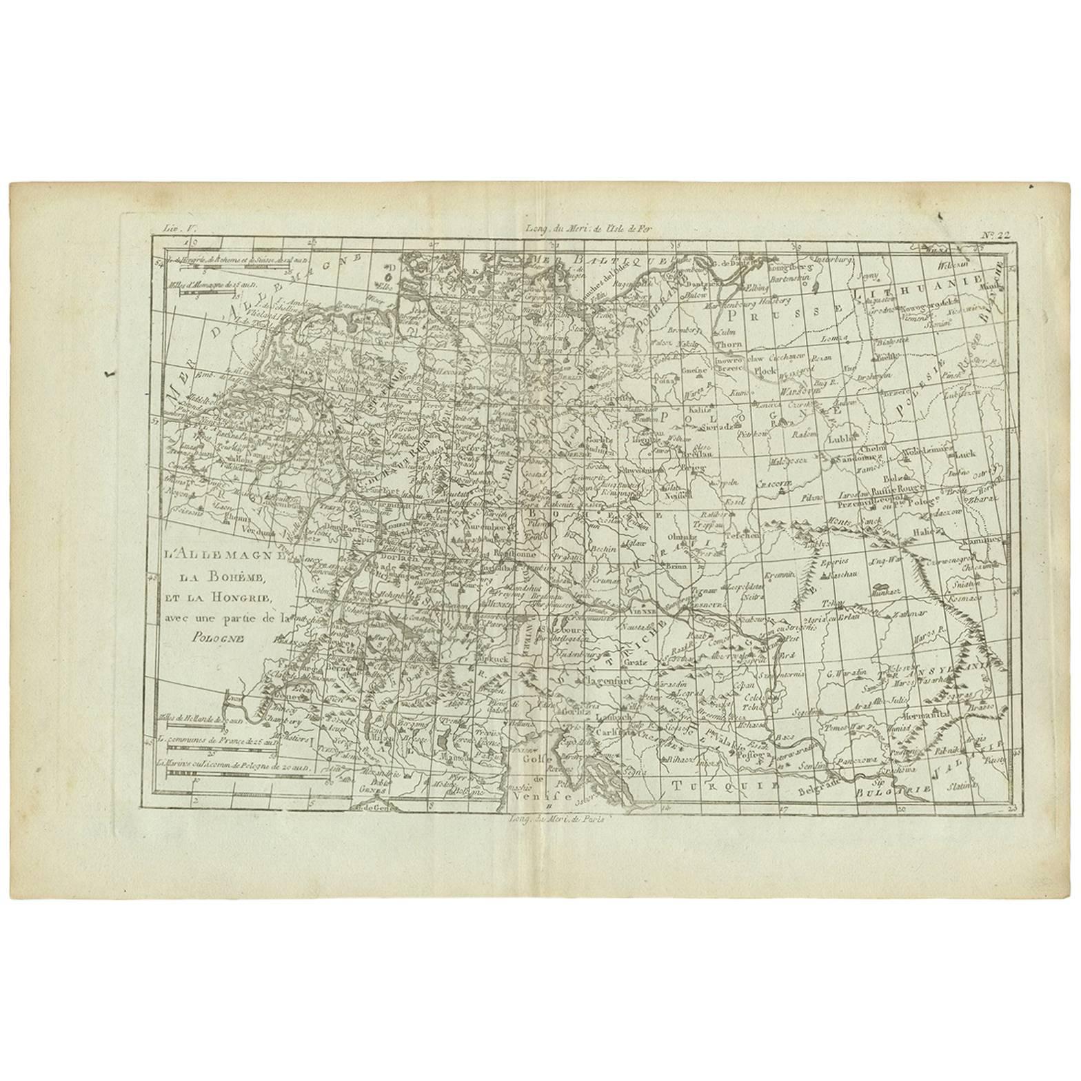
Antique Map of Germany, Bohemia, Hungary and Part of Poland by R. Bonne ‘1780’
Located in Langweer, NL
Antique map titled "L'Allemagne, La Bohême, et la Hongrie avec une partie de la Pologne" by Rigobert Bonne (1729-1795) for "Atlas de toutes les parties connues du globe terrestre" by...
Category
Antique Late 18th Century French Maps
Materials
Paper
Antique Map of Hungary and Transylvania by Isaak Tirion, Amsterdam c.1740
Located in Langweer, NL
Poland Map 1740s – Nieuwe Kaart van het Koninryk Poolen by Isaak Tirion
This finely engraved and attractively hand-colored map of the Kingdom of Poland was published by Isaak Tirion...
Category
Antique Mid-18th Century Dutch Maps
Materials
Paper
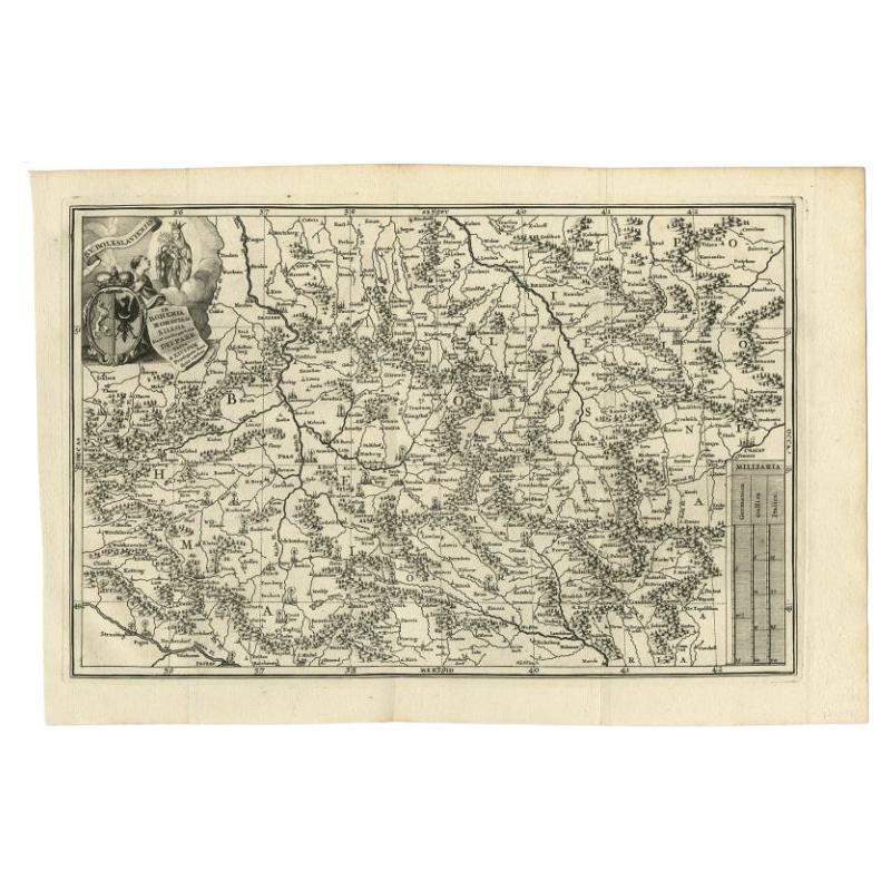
Antique Uncommon Map of Bohemia, Moravia and Silesia, 1699
Located in Langweer, NL
Antique map titled 'B. V. Boleslaviensis in Bohemia, Moravia et Silesia (..).' Detailed uncommon map of the Bohemia, Moravia and Silesia. Source unknown, to be determined.
Artists...
Category
Antique 17th Century Maps
Materials
Paper