Items Similar to Original Antique Map of Normandy, France

Want more images or videos?
Request additional images or videos from the seller
1 of 6
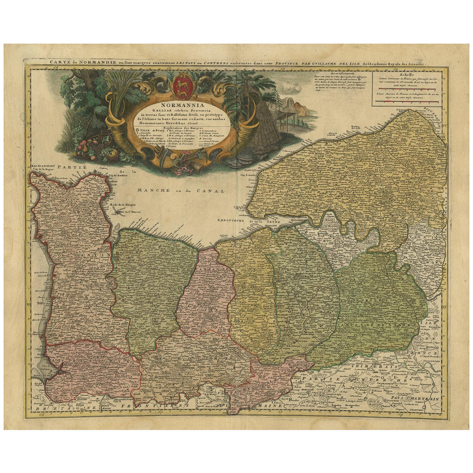
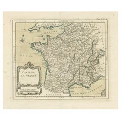
Original Antique Map of Normandy, France
$755.03
$943.7920% Off
£564.27
£705.3420% Off
€632
€79020% Off
CA$1,041.61
CA$1,302.0120% Off
A$1,140.88
A$1,426.1020% Off
CHF 600.68
CHF 750.8420% Off
MX$13,616.06
MX$17,020.0820% Off
NOK 7,655.07
NOK 9,568.8320% Off
SEK 6,997.88
SEK 8,747.3620% Off
DKK 4,817.19
DKK 6,021.4920% Off
About the Item
Antique map titled 'Carte de Normandie (..)'. Attractive map of Normandy, France. it depicts the former French Duchy of Normandy, covers the region from Cherbourg south as far as Pontorson and from Chartres north to Le Treport. By Gauillaume de l'Isle, published circa 1745.
- Dimensions:Height: 20.28 in (51.5 cm)Width: 27.05 in (68.7 cm)Depth: 0.02 in (0.5 mm)
- Materials and Techniques:
- Period:
- Date of Manufacture:c.1745
- Condition:Minor fading. Original/contemporary hand coloring. Original folding line. General age-related toning. Shows some overall wear and staining in upper part of the map. Narrow margins. Blank verso. Please study image carefully.
- Seller Location:Langweer, NL
- Reference Number:Seller: BG-13397-241stDibs: LU3054333827722
About the Seller
5.0
Recognized Seller
These prestigious sellers are industry leaders and represent the highest echelon for item quality and design.
Platinum Seller
Premium sellers with a 4.7+ rating and 24-hour response times
Established in 2009
1stDibs seller since 2017
2,806 sales on 1stDibs
Typical response time: 1 hour
- ShippingRetrieving quote...Shipping from: Langweer, Netherlands
- Return Policy
More From This Seller
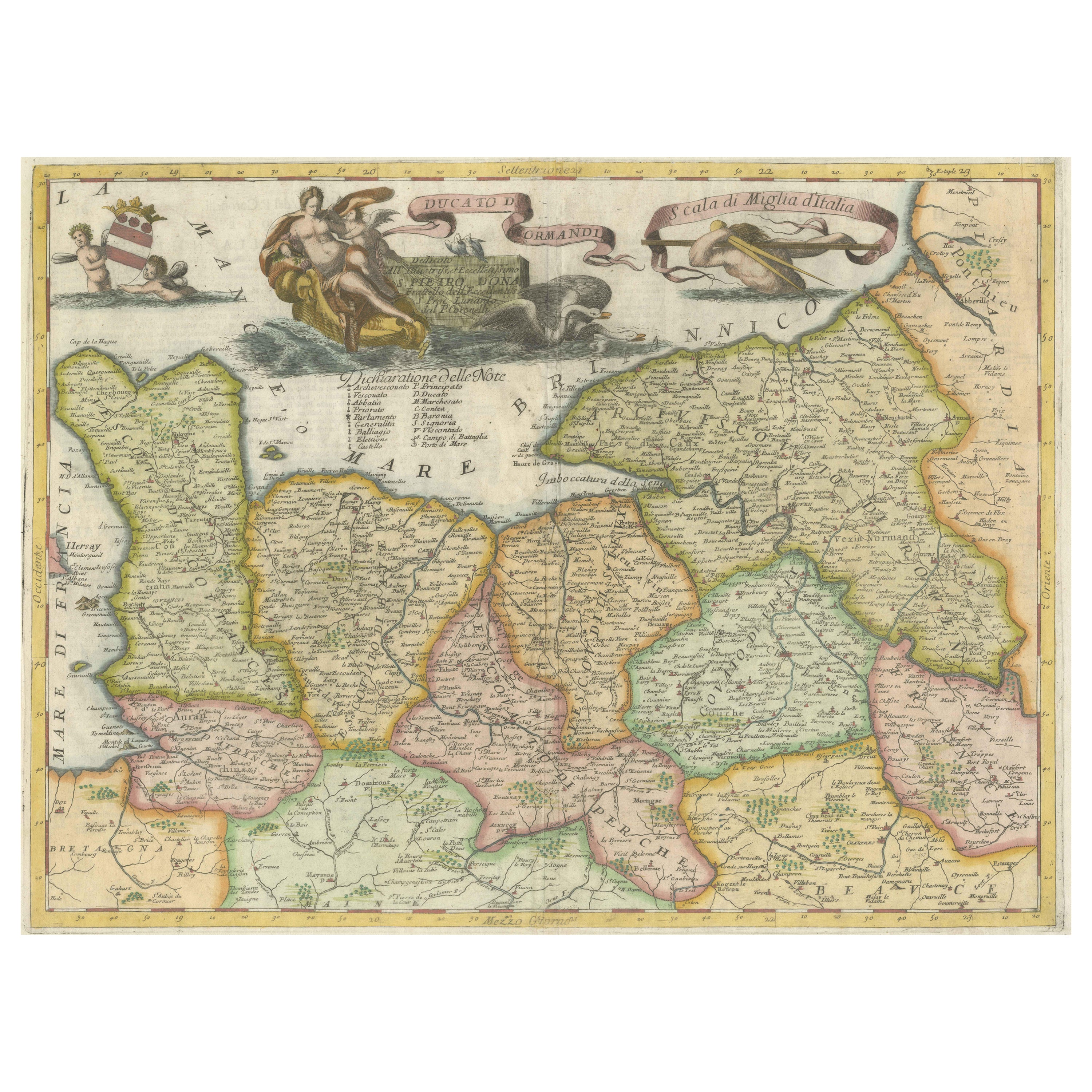
View AllDecorative Original Antique Map of Normandy, France, circa 1690
Located in Langweer, NL
Original antique map titled 'Ducato D'Normandie Scala di Miglia d'Italia'. Very decorative map of Normandy, with a fine title cartouche featuring Leda ...
Category
Antique Late 17th Century Italian Maps
Materials
Paper

Antique Map of ancient France by Zannoni, 1765
Located in Langweer, NL
Antique map France titled 'Galliae Veteris (..)'. Beautiful old map of France. This map originates from 'Atlas Historique de la France Ancienne et Moderne' ...
Category
Antique 18th Century Maps
Materials
Paper

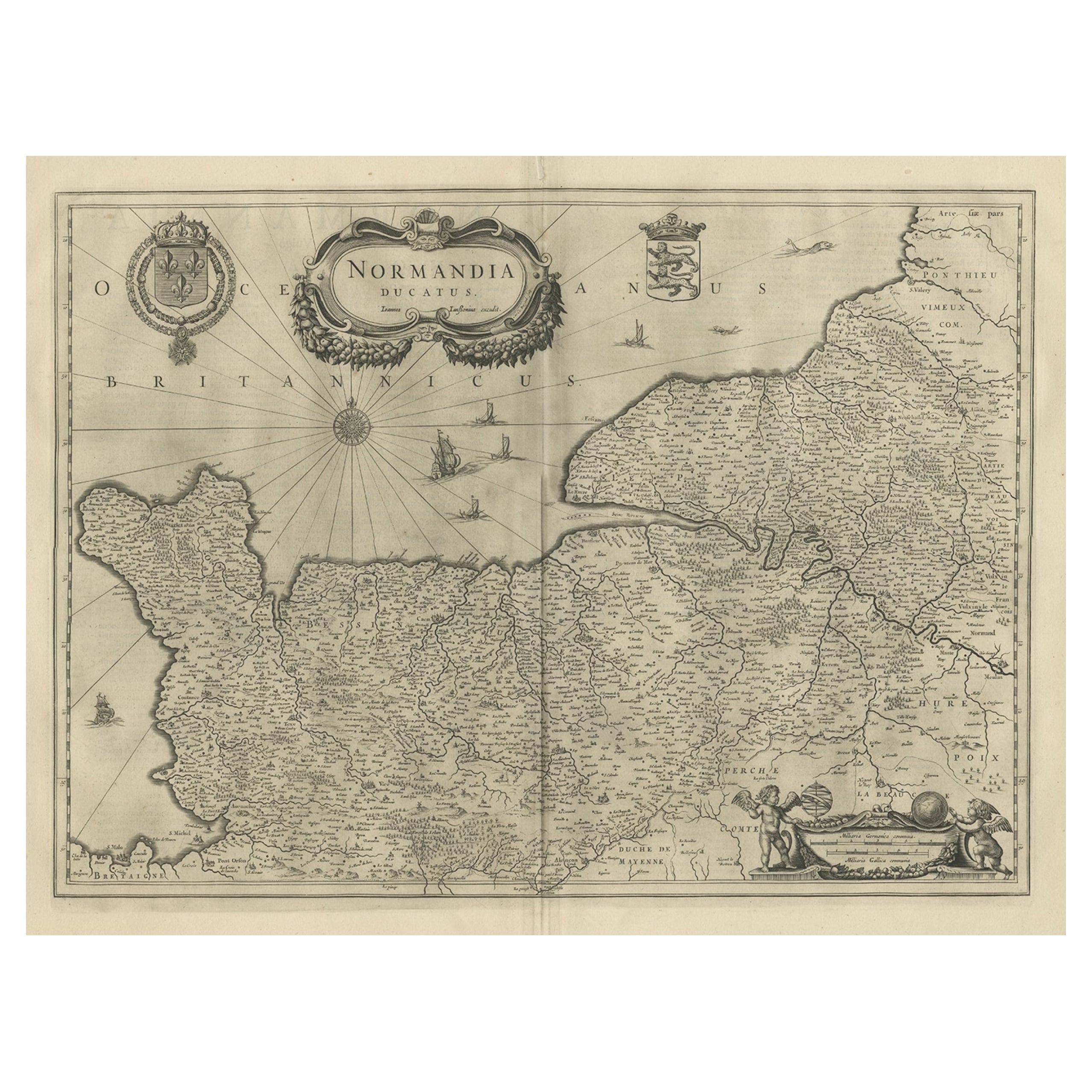
Antique Map Normandy
France
by Homann Heirs, Published in c.1740
By Homann Heirs
Located in Langweer, NL
Antique map France titled 'Normannia Galliae celebris Provincia in terras suas Ballisiatus (..)'.
Decorative regional map of Normandy, France, circa ...
Category
Antique Mid-18th Century German Maps
Materials
Paper
$764 Sale Price
5% Off
Antique Map of Normandy by Janssonius, 1657
Located in Langweer, NL
Antique map of France titled 'Normandia Ducatus'. Decorative map of the Normandy region, including decorative cartouche, sailing ships and compass rose. This map originates from 'Atl...
Category
Antique 17th Century Maps
Materials
Paper
$342 Sale Price
20% Off
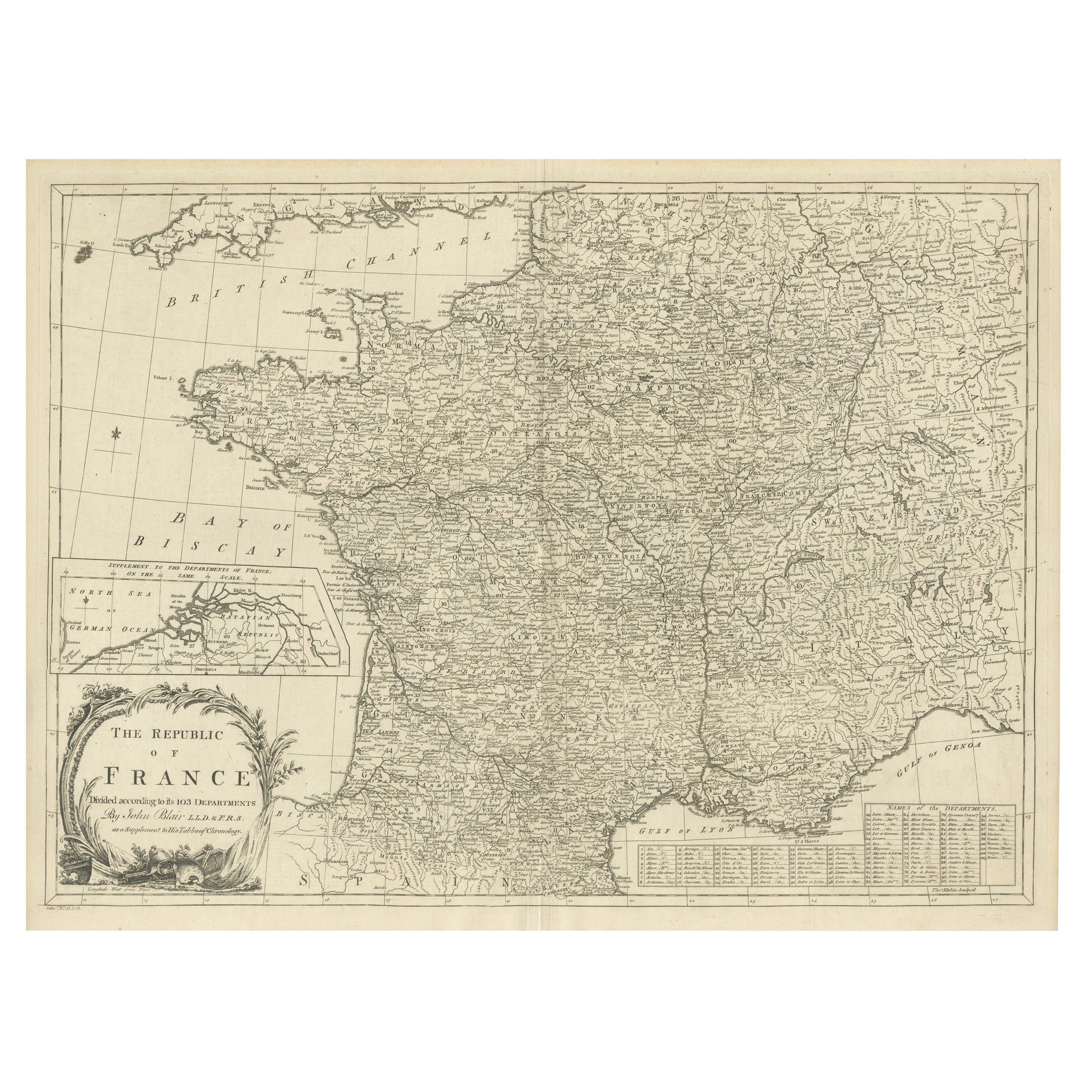
Antique Map of France with Inset showing the Northern Departments
Located in Langweer, NL
Antique map titled 'The Republic of France divided according to its 103 Departments'. Decorative map of France. Includes a large cartouche and an in...
Category
Antique Late 18th Century Maps
Materials
Paper
$630 Sale Price
20% Off
Antique Map of France with Decorative Title Cartouche
Located in Langweer, NL
Antique map titled 'Carte de la France'. Original old map of France. This map originates from 'Le Petit Atlas Maritime Recueil De Cartes et Plans Des Quatre Parties Du Monde (..) by ...
Category
Antique Mid-18th Century Maps
Materials
Paper
$229 Sale Price
20% Off
You May Also Like
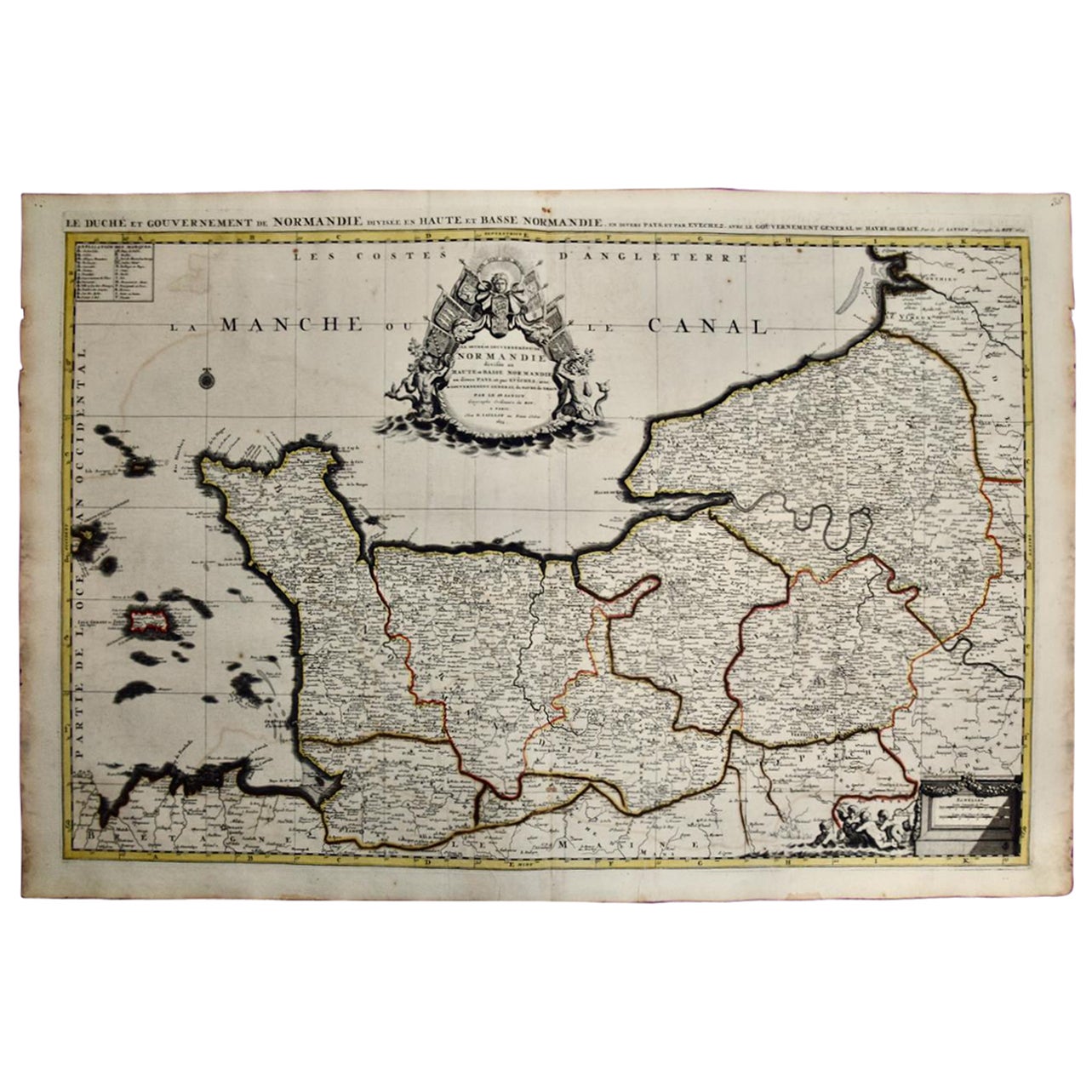
The Normandy Region of France: A 17th C. Hand-colored Map by Sanson and Jaillot
By Nicolas Sanson
Located in Alamo, CA
This large hand-colored map entitled "Le Duché et Gouvernement de Normandie divisée en Haute et Basse Normandie en divers Pays; et par evêchez, avec le Gouvernement General du Havre ...
Category
Antique 1690s French Maps
Materials
Paper

1752 Vaugoundy Map of Flanders : Belgium, France, and the Netherlands, Ric.a002
Located in Norton, MA
Large Vaugoundy Map of Flanders:
Belgium, France, and the Netherlands
Colored -1752
Ric.a002
Description: This is a 1752 Didier Robert de Vaugondy map of Flanders. The map de...
Category
Antique 17th Century Unknown Maps
Materials
Paper

1771 Bonne Map of Poitou, Touraine and Anjou, France, Ric.a015
Located in Norton, MA
1771 Bonne Map of Poitou,
Touraine and Anjou, France
Ric.a015
1771 Bonne map of Potiou, Touraine and Anjou entitled "Carte des Gouvernements D'Anjou et du Saumurois, de la Touraine, du Poitou,du Pays d'aunis, Saintonge?Angoumois,"
Carte des gouvernements d'Anjou et du Saumurois, de la Touraine, du Poitou, du Pays d'Aunis, Saintonge-Angoumois. Projettee et assujettie au ciel par M. Bonne, Hyd. du Roi. A Paris, Chez Lattre, rue St. Jacques a la Ville de Bord(ea)ux. Avec priv. du Roi. 1771. Arrivet inv. & sculp., Atlas moderne ou collection de cartes sur toutes...
Category
Antique 17th Century Unknown Maps
Materials
Paper

Large 19th Century Map of France
Located in Pease pottage, West Sussex
Large 19th Century Map of France.
Remarkable condition, with a pleasing age worn patina.
Recently framed.
France Circa 1874.
Category
Antique Late 19th Century French Maps
Materials
Linen, Paper

France, Northern Part. Century Atlas antique map
Located in Melbourne, Victoria
'The Century Atlas. France, Northern Part.'
Original antique map, 1903.
Inset maps of 'France in Provinces' and 'Paris and Vicinity'.
Central fold as issued. Map name and number pr...
Category
Early 20th Century Victorian More Prints
Materials
Lithograph

Antique Map of France
Located in Dallas, TX
Nice antique map of France in wood frame. This would make a great gift for a collector. A wonderful accessory!
Category
Early 20th Century Decorative Art
Materials
Glass, Wood, Paper

$1,760
More Ways To Browse
1681 Moses Pitt
Antique Map Bermuda
Antique Map Of Brooklyn
Antique Map Of Republic Of Texas
Extra Large Map
George Weymouth
Georgetown Map
Hemisphere Antiques
J Matthews
Japanese Kite
Maltese Falcon
Map Tuscany
St Eustatius
Sumba Map
Used Furniture Denver Co
Used Furniture Leominster
Vintage Long Island Map
Vintage World Map Desk