Items Similar to Original Antique Map of Trier and Luxembourg by Joan Blaeu, Amsterdam circa 1640


Want more images or videos?
Request additional images or videos from the seller
1 of 10
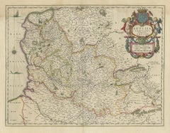
Original Antique Map of Trier and Luxembourg by Joan Blaeu, Amsterdam circa 1640
$1,424.14
£1,062.31
€1,200
CA$1,982.18
A$2,126.53
CHF 1,140.63
MX$25,603.10
NOK 14,378.92
SEK 13,111.58
DKK 9,144.91
About the Item
Map of Trier and Luxembourg by Joan Blaeu, Amsterdam circa 1640
This beautifully engraved and hand-colored map titled Trevirensis Archiepiscopatus, et Lutzenburgi Ducatus depicts the Archbishopric of Trier and the Duchy of Luxembourg, regions now part of western Germany and eastern Belgium. It was published around 1640 by Joan Blaeu in Amsterdam and is a fine example of mid-17th-century Dutch cartography at its peak.
The map captures the heart of the Rhineland-Palatinate and surrounding areas, including parts of present-day Luxembourg, with exceptional clarity and topographical detail. Rivers, cities, mountain ranges, and forests are carefully illustrated, reflecting the advanced surveying techniques and artistic style of the Blaeu workshop. Towns such as Trier, Luxembourg, and Koblenz are clearly marked, with roads and borders delineated in elegant, hand-colored outlines.
A prominent decorative title cartouche in the lower left corner, flanked by coats of arms of Trier and Luxembourg, lends the map a ceremonial and heraldic quality. This map was included in various editions of the Atlas Novus and later Atlas Maior, Blaeu’s monumental multi-volume world atlas, widely considered one of the most beautiful cartographic works ever published.
Joan Blaeu (1596–1673), the son of Willem Janszoon Blaeu, was a master mapmaker who continued and expanded his family’s cartographic legacy. He was the official cartographer of the Dutch East India Company and produced some of the most accurate and artistically accomplished maps of the period. His maps are known for their precision, vibrant coloring, and aesthetic appeal, making them enduring favorites among collectors.
This map is an important historical document as well as a decorative work of art, suitable for framing and display in any collection of early European or ecclesiastical geography.
Condition summary:
Very good condition with original hand-coloring. Slight age toning and a faint central fold, as issued. No tears or repairs. Crisp plate impression and full margins. A clean and well-preserved example of 17th-century mapmaking.
Framing tip:
Frame in a dark oak or gold-leaf wooden frame with a pale ivory mat. Use UV-protective glass to preserve the delicate hand-coloring. Ideal for traditional or academic interiors with historical or classical décor themes.
- Dimensions:Height: 19.73 in (50.1 cm)Width: 22.01 in (55.9 cm)Depth: 0.01 in (0.2 mm)
- Materials and Techniques:Paper,Engraved
- Place of Origin:
- Period:Mid-17th Century
- Date of Manufacture:circa 1640
- Condition:Very good condition with original hand-coloring. Slight age toning and a faint central fold, as issued. No tears or repairs. Crisp plate impression and full margins. A clean and well-preserved example of 17th-century mapmaking.
- Seller Location:Langweer, NL
- Reference Number:Seller: BG-14092-21stDibs: LU3054345467482
About the Seller
5.0
Recognized Seller
These prestigious sellers are industry leaders and represent the highest echelon for item quality and design.
Platinum Seller
Premium sellers with a 4.7+ rating and 24-hour response times
Established in 2009
1stDibs seller since 2017
2,830 sales on 1stDibs
Typical response time: 1 hour
- ShippingRetrieving quote...Shipping from: Langweer, Netherlands
- Return Policy
More From This Seller
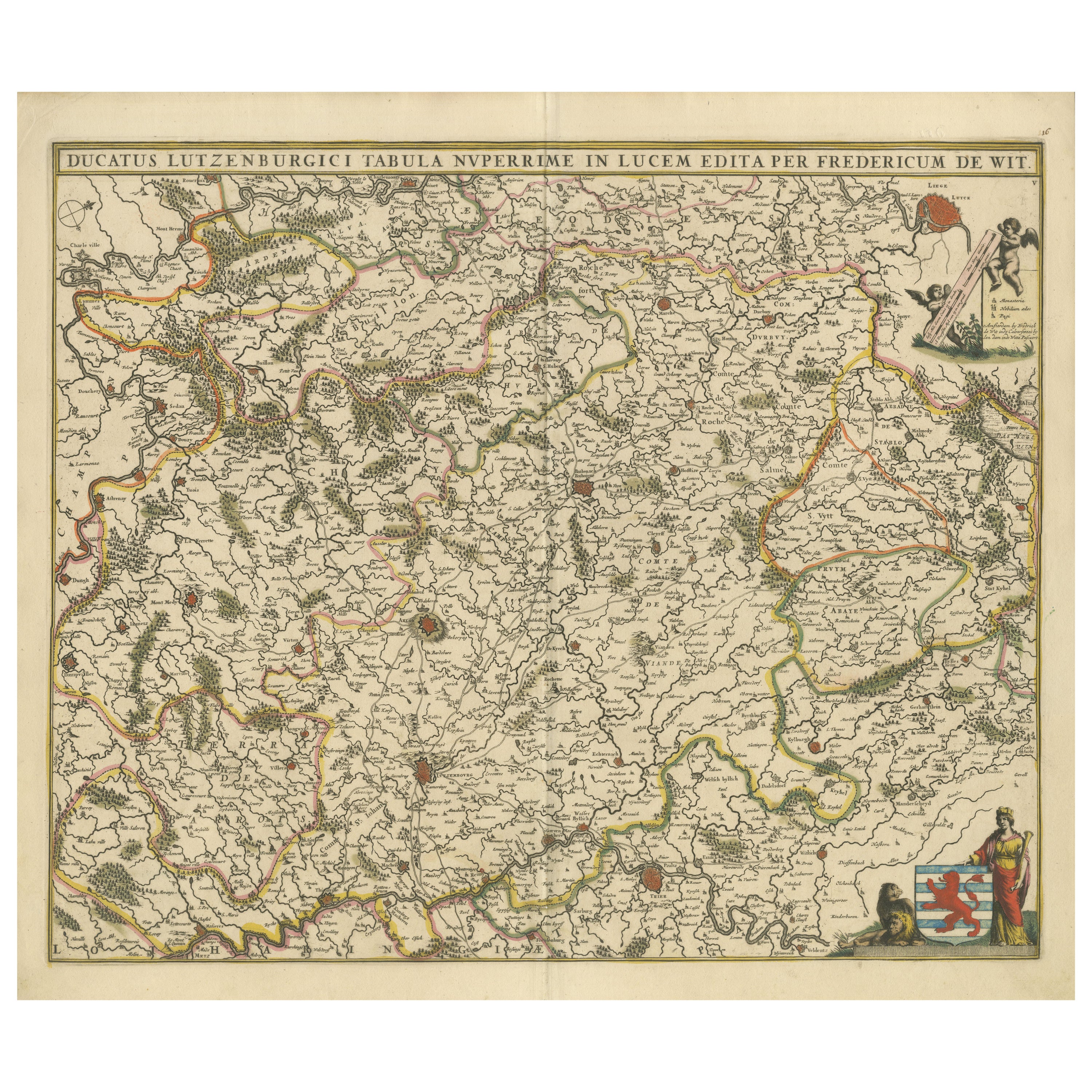
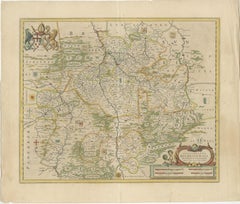
View AllOriginal Antique Map of the Duchy of Luxembourg by De Wit, Amsterdam circa 1680
Located in Langweer, NL
Map of the Duchy of Luxembourg by De Wit, Amsterdam circa 1680
Rare original antique map of the Duchy of Luxembourg by Frederick de Wit, published in Amsterdam circa 1680. A highly ...
Category
Antique Late 17th Century Dutch Maps
Materials
Paper
Antique Map of the Namur Region
France
by F. de Wit, circa 1680
Located in Langweer, NL
Antique map titled 'Comitatus Namurci Tabula in Lucem Edita'. Large map of the Namur region, France. Published by F. de Wit, circa 1680.
Category
Antique Late 17th Century Maps
Materials
Paper

$545 Sale Price
20% Off
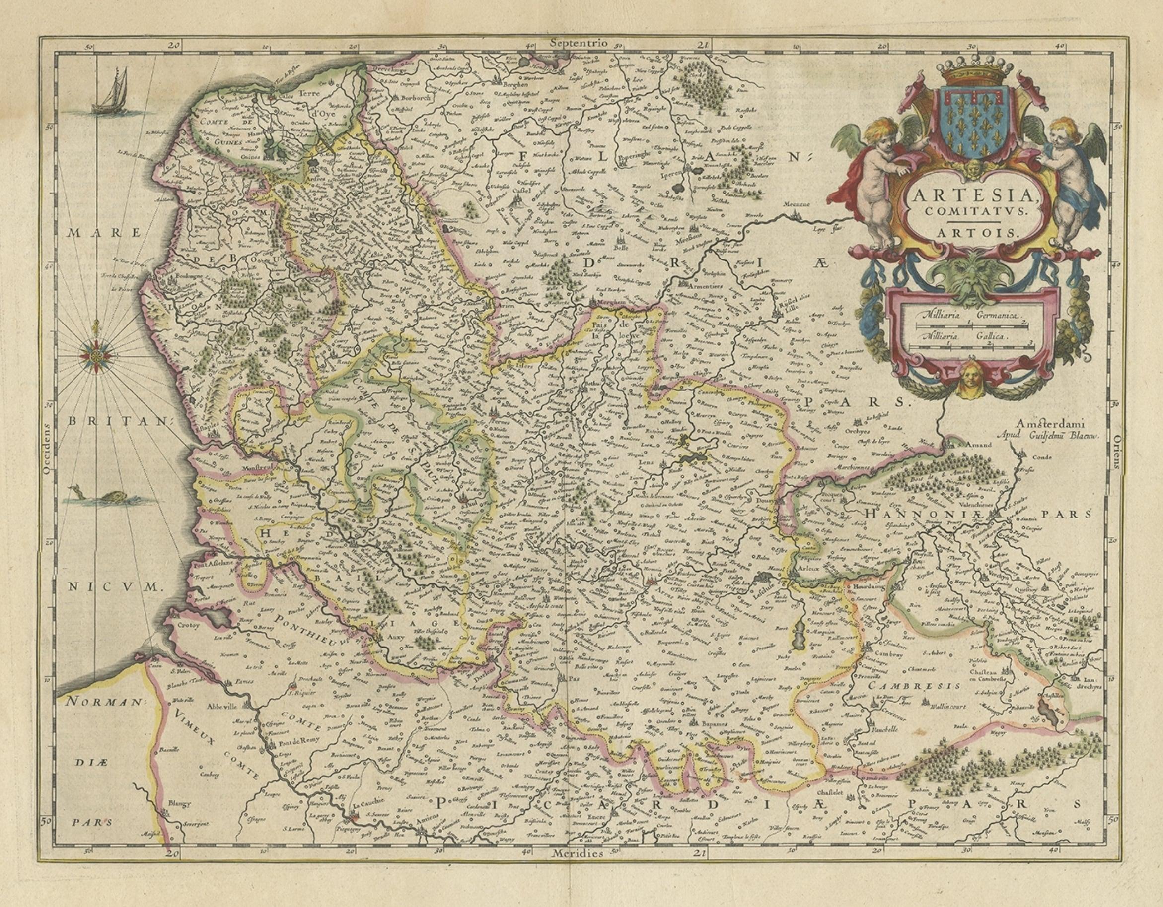
Antique Map of Artois in the North of France by Famous Mapmaker Blaeu, c.1640
Located in Langweer, NL
Antique map titled 'Artesia Comitatus Artois'. Map of Artois or Artesia, France. Artois is former province located in the northwestern part of France, boarding Belgium (Flanders) on ...
Category
Antique 17th Century Maps
Materials
Paper
Bishopric of Hildesheim Map in Northern Germany by Willem
Joan Blaeu, 1645
Located in Langweer, NL
This beautifully hand-colored map, titled "Episcopatus Hildesiensis Descriptio Novissima," depicts the Bishopric of Hildesheim, a historical ecclesiastical territory in present-day L...
Category
Antique 1640s Maps
Materials
Paper
$493 Sale Price
20% Off
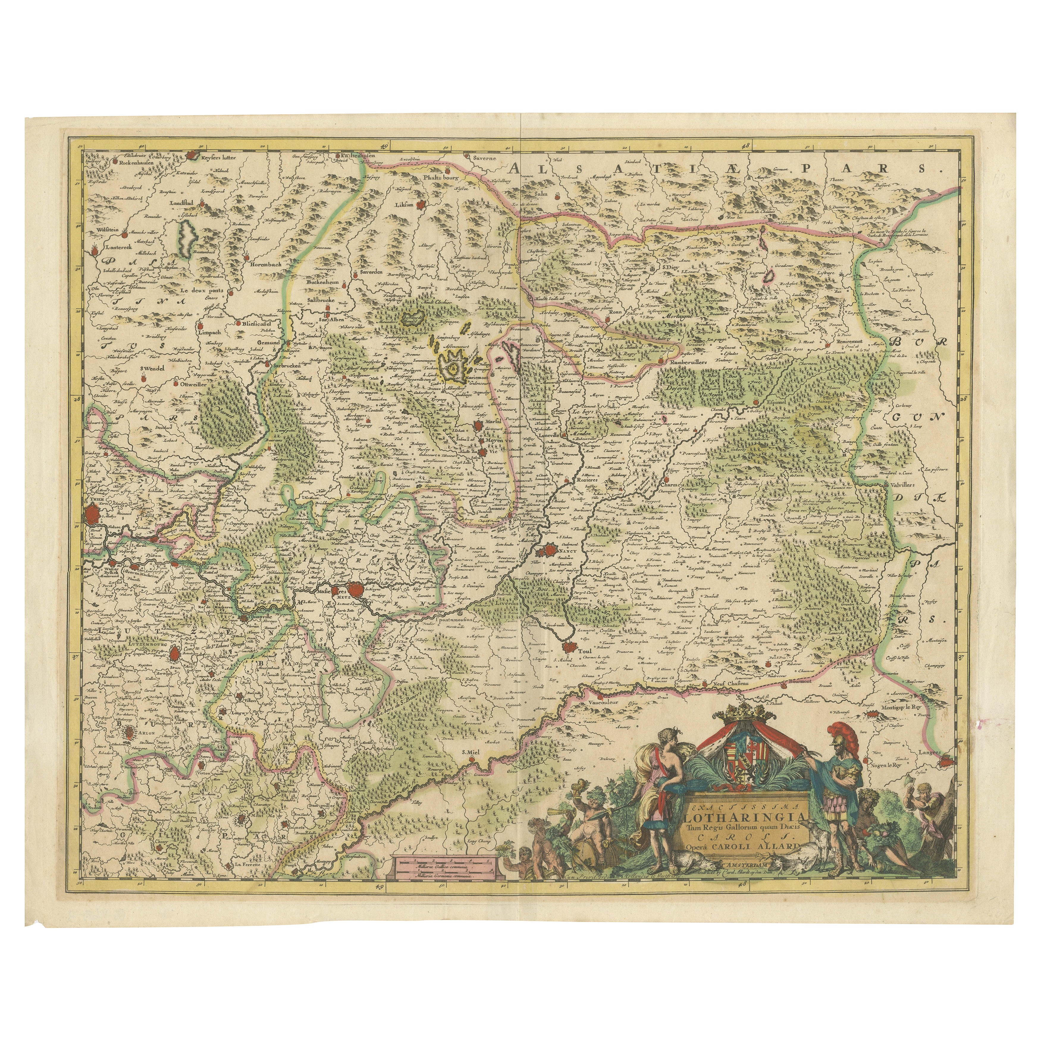
Historic 1690 Map of Lorraine in France by Allard - Cities of Toul, Nancy, Metz
Located in Langweer, NL
Exactissima Lotharingia - A Rare 17th Century Map of Lorraine by Carel Allard
This fascinating map of Lorraine, created by Carel Allard around 1690, is a stunning example of coppe...
Category
Antique 1690s Maps
Materials
Paper
Antique Map of the Hainaut Region
France
by F. de Wit, circa 1680
Located in Langweer, NL
Antique map titled 'Comitatus Hannoniae et Episcopatus Cambresis Descriptio'. Large map of the Hainaut region, France. Published by F. de Wit, circa 1680.
Category
Antique Late 17th Century Maps
Materials
Paper

$545 Sale Price
20% Off
You May Also Like
1640 Willem Blaeu Map Entitled "Contado di molise et principato vltra, " Ric.a003
By Willem Blaeu
Located in Norton, MA
1640 Willem Blaeu map entitled
"Contado di molise et principato vltra,"
Colored
Ric. a003
Measures: 38 x 49.6 cm and wide margins
DBLAEU.
Cou...
Category
Antique 17th Century Dutch Maps
Materials
Paper

1635 Willem Blaeu Map of Northern France"Comitatvs Bellovacvm" Ric.a08
Located in Norton, MA
1635 Willem Blaeu map of northern France, entitled.
"Comitatvs Bellovacvm Vernacule Beavvais,"
Colored
Ric.a008
“COMITATVS BELLOVACVM…” Amsterdam: W...
Category
Antique 17th Century Unknown Maps
Materials
Paper

17th Century Hand-Colored Map of a Region in West Germany by Janssonius
By Johannes Janssonius
Located in Alamo, CA
This attractive highly detailed 17th century original hand-colored map is entitled "Archiepiscopatus Maghdeburgensis et Anhaltinus Ducatus cum terris adjacentibus". It was published ...
Category
Antique Mid-17th Century Dutch Maps
Materials
Paper

1640 Joan Bleau Map Entitled"Diocecese de rheims et le pais de rethel, " Eic.a011
Located in Norton, MA
1640 Joan Bleau map entitled
"Diocecese de rheims et le pais de rethel,"
Ric.a011
OAN BLAEU
Diocecese de Rheims, et le pais de Rethel.
Handcolored engraving, c.1640.
...
Category
Antique 17th Century Dutch Maps
Materials
Paper

17th Century Hand Colored Map of the Liege Region in Belgium by Visscher
By Nicolaes Visscher II
Located in Alamo, CA
An original 17th century map entitled "Leodiensis Episcopatus in omnes Subjacentes Provincias distincté divisusVisscher, Leodiensis Episcopatus" by Nicolaes Visscher II, published in Amsterdam in 1688. The map is centered on Liege, Belgium, includes the area between Antwerp, Turnhout, Roermond, Cologne, Trier and Dinant.
This attractive map is presented in a cream-colored mat measuring 30" wide x 27.5" high. There is a central fold, as issued. There is minimal spotting in the upper margin and a tiny spot in the right lower margin, which are under the mat. The map is otherwise in excellent condition.
The Visscher family were one of the great cartographic families of the 17th century. Begun by Claes Jansz Visscher...
Category
Antique Late 17th Century Dutch Maps
Materials
Paper

West Germany: Original Hand Colored 17th Century Map by Johannes Janssonius
By Johannes Janssonius
Located in Alamo, CA
An original hand colored copperplate engraved map entitled in Latin "Archiepiscopatus Maghdeburgensis et Anhaltinus Ducatus cum terris adjacentibus", published in Amsterdam in 1640 i...
Category
Mid-17th Century Old Masters More Prints
Materials
Engraving

More Ways To Browse
Holland And Company
Used Furniture Luxembourg
Antique Victorian Dining Tables
Italian Plastic Chairs
Black Crystal Glasses
French Mid Century Modern Rug
China Silk Rug
Chrome Glass Coffee Tables
Antique Italian Chairs
Antique Walnut Bar
Beni Ourain Rugs
French Iron And Glass Table
Glass Top Wood Base Coffee Tables
T Chair
Antique Silver Basket
Antique Walkers
Ebony Wood Furniture
Opalescent Glass