Items Similar to Original Antique Map of the West Indies by J. Arrowsmith, 1842


Want more images or videos?
Request additional images or videos from the seller
1 of 9
Original Antique Map of the West Indies by J. Arrowsmith, 1842
$947.96
$1,184.9520% Off
£704.36
£880.4520% Off
€792
€99020% Off
CA$1,298.51
CA$1,623.1420% Off
A$1,416.61
A$1,770.7620% Off
CHF 751.34
CHF 939.1720% Off
MX$17,066.92
MX$21,333.6520% Off
NOK 9,535.96
NOK 11,919.9520% Off
SEK 8,730.43
SEK 10,913.0420% Off
DKK 6,033.36
DKK 7,541.7020% Off
About the Item
Title: "J. Arrowsmith's 19th Century Map of the West Indies"
This original antique map, crafted by J. Arrowsmith, details the West Indies with a focus on the Caribbean Sea and its surrounding landmasses, including Florida, the Gulf of Mexico, and the northern coastline of South America.
The map, characterized by its fine engraving and delicate hand coloring, illustrates the various islands and key ports of the region, all meticulously labeled. It provides a historical perspective on the geography and colonial interests of the time. The subtlety of the color palette and the precision of the cartographic details not only make it a navigational piece but also a work of art. Notable for its comprehensive depiction of the Caribbean islands, this map is a testament to the skill and craftsmanship of 19th-century cartography, embodying both the scientific knowledge and the aesthetic sensibilities of the era.
The map depicts a large number of islands in the West Indies, which includes the Caribbean islands. Some of the primary landmasses and island groups visible include:
1. The large island at the left is part of Florida and the adjacent Florida Keys.
2. Cuba is the large island below Florida, to the left.
3. The Bahamas are to the northeast of Cuba.
4. Hispaniola, divided into Haiti (western portion) and the Dominican Republic (eastern portion), is to the east of Cuba.
5. Jamaica is located south of Cuba.
6. Puerto Rico is to the east of Hispaniola.
7. The Lesser Antilles, including both the Leeward Islands and the Windward Islands, arc towards the southeast from Puerto Rico.
8. The northern coast of South America, including parts of Colombia and Venezuela, is at the bottom right.
These islands are part of a larger archipelago in the Caribbean Sea and are significant both geographically and historically. The map appears to detail the various smaller islands and cays that make up this region, each with its own topographical features and colonial affiliations as of the date of the map's creation.
J. Arrowsmith refers to John Arrowsmith, a renowned British cartographer and member of the Arrowsmith family of geographers. He was born in 1790 and became one of the most respected mapmakers of the 19th century. John Arrowsmith was known for his meticulous attention to detail and his commitment to updating maps with the latest geographical knowledge.
He established his own business in London in the 1830s, where he published a series of maps and charts which were highly praised for their accuracy and craftsmanship. Arrowsmith's maps covered all parts of the world and were used extensively for exploration, navigation, and colonization purposes. He was awarded the Gold Medal of the Royal Geographical Society of which he was a member.
John Arrowsmith's uncle, Aaron Arrowsmith, was also a distinguished cartographer, and his work set a high standard which John continued. The Arrowsmiths' maps were distinctive for their clarity and lack of unnecessary decoration, focusing instead on providing reliable information for the map's users.
John Arrowsmith's contribution to cartography was significant during a period when geographical knowledge was rapidly expanding due to exploration, particularly in the Australian continent and the Canadian Arctic. His maps remain important historical documents and collectibles for their beauty and the wealth of information they provide.
The map by J. Arrowsmith appears to be in relatively good condition for its age. The paper has retained its structure without any noticeable large tears or areas of loss. There is a natural aged tone to the paper, which is common for documents of this vintage, and it adds to its antique character.
The colors on the map, though likely faded over time, still seem to have some vibrancy, suggesting the map has been reasonably well-preserved, possibly stored away from direct sunlight or in a climate-controlled environment to prevent significant deterioration.
There are signs of folding or creasing, as indicated by the vertical and horizontal lines across the map, which is typical for maps that were designed to be folded for use or inserted into atlases. The edges show some wear, and there might be minor fraying or chipping, which is also consistent with the handling of maps over many years.
Overall, the map's legibility is maintained, with text and cartographic details remaining clear, indicating that it has been cared for. For collectors or those interested in historical maps, its condition would likely be deemed satisfactory, especially given that such signs of aging are expected and often contribute to the map's historical value.
- Dimensions:Height: 20.87 in (53 cm)Width: 27.17 in (69 cm)Depth: 0 in (0.02 mm)
- Materials and Techniques:
- Period:
- Date of Manufacture:1842
- Condition:Some folds and creases, which is typical for maps that were designed to be folded for use or inserted into atlases. The edges show some wear, and creases but once framed a beautiful piece.
- Seller Location:Langweer, NL
- Reference Number:Seller: BG-13618-51stDibs: LU3054337731372
About the Seller
5.0
Recognized Seller
These prestigious sellers are industry leaders and represent the highest echelon for item quality and design.
Platinum Seller
Premium sellers with a 4.7+ rating and 24-hour response times
Established in 2009
1stDibs seller since 2017
2,820 sales on 1stDibs
Typical response time: 1 hour
- ShippingRetrieving quote...Shipping from: Langweer, Netherlands
- Return Policy
More From This Seller
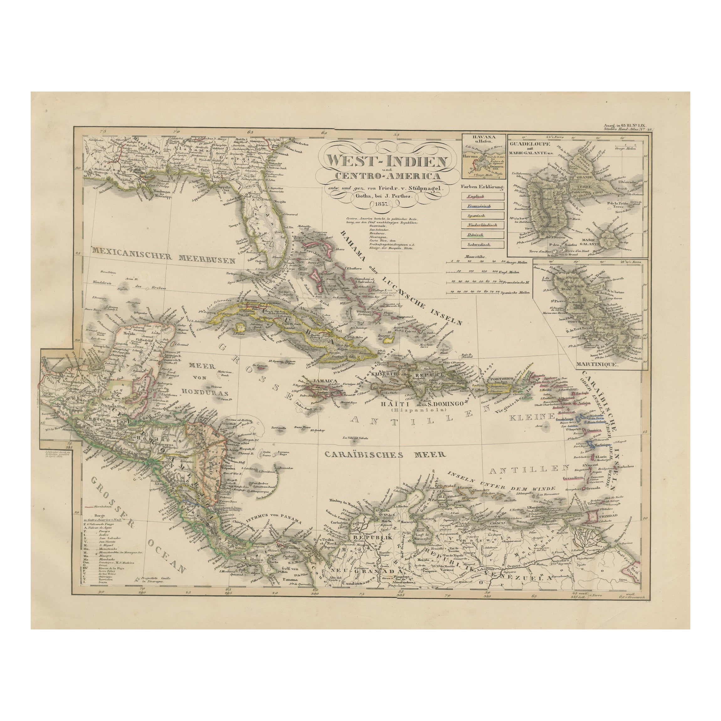
View AllAntique Map of the Caribbean
Central America – West Indies, 1857
Located in Langweer, NL
Antique Map of the Caribbean & Central America – West Indies, 1857
This finely engraved and hand-colored map titled "West-Indien und Centro-America" was published in 1857 by Justus ...
Category
Antique Mid-19th Century German Maps
Materials
Paper
Antique Map of the West Indies and Central America by W. G. Blackie, 1859
Located in Langweer, NL
Antique map titled 'The West India Island & Central America'. Original antique map of the West Indies and Central America, with inset map of Jamaica. Th...
Category
Antique Mid-19th Century Maps
Materials
Paper

$239 Sale Price
20% Off
Antique Map of the Antilles in the Caribbean,
1875
Located in Langweer, NL
Antique map titled 'Carte des Iles Antilles'. Large map of the Antilles. This map originates from 'Atlas de Géographie Moderne Physique et Politique' by A. Levasseur. Published, 1875.
Category
Antique Late 19th Century French Maps
Materials
Paper

$329 Sale Price
44% Off
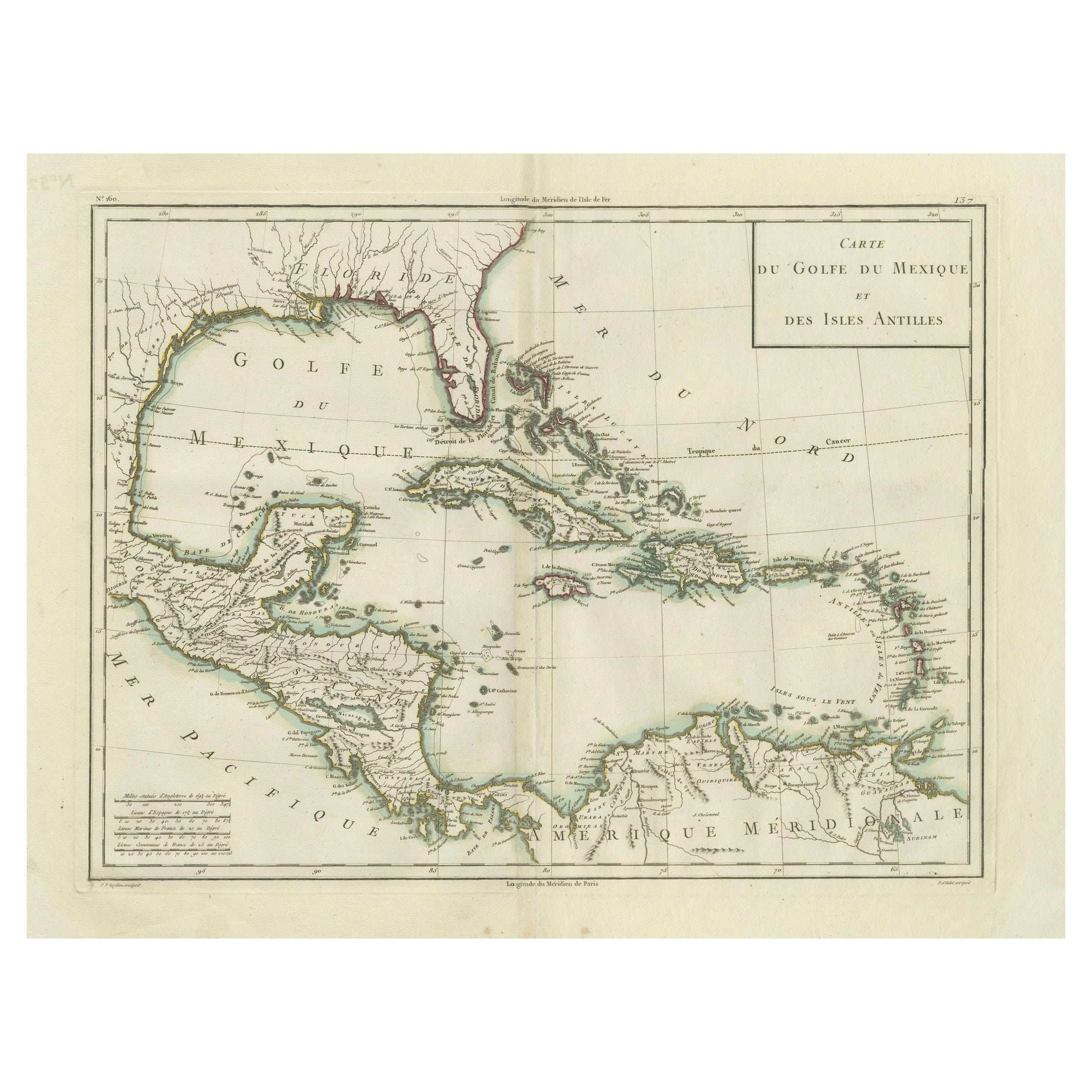
Antique Map of the Gulf of Mexico and Caribbean Islands by Tardieu, 1802
Located in Langweer, NL
This is an original antique map titled "Carte du Golfe du Mexique et des Isles Antilles," depicting the Gulf of Mexico and the Caribbean islands. Created by Pierre Antoine Tardieu, t...
Category
Antique Early 1800s Maps
Materials
Paper
$536 Sale Price
20% Off
Antique Map of the West Indies and Central America by Lowry
1852
Located in Langweer, NL
Antique map titled 'West Indies and Central America'. Original map of the West Indies and Central America. This map originates from 'Lowry's Table Atlas constructed and engraved from...
Category
Antique Mid-19th Century Maps
Materials
Paper

$95 Sale Price
20% Off
Authentic Antique Map of the Caribbean, Gulf Coast and Central America, 1787
Located in Langweer, NL
Antique map titled 'Les Isles Antilles et le Golfe du Méxique'. Original old map of the Caribbean, Gulf Coast and Central America. With inset map of Bermuda...
Category
Antique Late 18th Century Maps
Materials
Paper

$296 Sale Price
20% Off
Free Shipping
You May Also Like
Large Original Antique Map of The West Indies by Sidney Hall, 1847
Located in St Annes, Lancashire
Great map of The West Indies
Drawn and engraved by Sidney Hall
Steel engraving
Original colour outline
Published by A & C Black. 1847
Unframed
Free shipping.
Category
Antique 1840s Scottish Maps
Materials
Paper

Original Antique Map of Central America / Florida, Arrowsmith, 1820
Located in St Annes, Lancashire
Great map of Central America.
Drawn under the direction of Arrowsmith.
Copper-plate engraving.
Published by Longman, Hurst, Rees, Orme and Brown, 1820
Unframed.
Category
Antique 1820s English Maps
Materials
Paper

Map Of The Island Of Cuba - Guillaume Thomas Raynal (1711-1796)
Located in Porto, PT
This historical map of the Island of Cuba was produced in the late 18th century and is taken from an edition of “Atlas de toutes les parties connues du globe terrestre” by the French...
Category
Antique 18th Century Prints
Materials
Glass, Paper

Early 19th Century Hand Colored Map of the United States and Caribbean Islands
Located in Hamilton, Ontario
Hand coloured early 19th century map by Giraldon of France titled "Etats Unis et Grandes Antilles" (United States and Greater Antilles).
Category
Antique Early 19th Century French Maps
Materials
Paper

$595 Sale Price
40% Off
Original Antique Map of The Western Hemisphere by Dower, circa 1835
Located in St Annes, Lancashire
Nice map of the Western Hemisphere
Drawn and engraved by J.Dower
Published by Orr & Smith. C.1835
Unframed.
Free shipping
Category
Antique 1830s English Maps
Materials
Paper

Map Colonies Francaises Martinique, 1845
Located in BUNGAY, SUFFOLK
Colonies Francaises, Martinique, Amerique DU SUD
Geographie et Statistique par V.Levasseur. Ing'r Geographe.
Illustre par Raymond Bonheur, peintre.
Grave par Laguihermie, Rue St...
Category
Antique 19th Century French Maps
Materials
Paper

More Ways To Browse
Stretcher Tables
M Table
Antique Sultanabad Carpets
China Chair
English Antique Desks
Used Beige Sofa
Antique Plate Germany
Hand Tufted Rugs
Rare China
Side Table Made In Denmark
Thonet Antique
Victorian Hall Tables
Vintage Computer
England Antique Plates
19th Century Round Dining Table
Antique Counters
Antique Thrones
Carved Chinese Tables