Want more images or videos?
Request additional images or videos from the seller
1 of 6
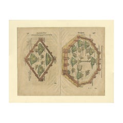
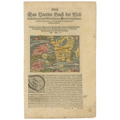
Original Antique Plan of the Harbor of Nettuno, Near Rome, by Munster, c.1580
$313.25List Price
About the Item
- Creator:Sebastian Münster (Artist)
- Dimensions:Height: 12.6 in (32 cm)Width: 8.15 in (20.7 cm)Depth: 0 in (0.01 mm)
- Materials and Techniques:
- Period:
- Date of Manufacture:C.1580
- Condition:Condition: Good, given age. Some crinkles, mainly outside image. General age-related toning and/or occasional minor defects from handling. Please study image carefully.
- Seller Location:Langweer, NL
- Reference Number:Seller: PCT-614351stDibs: LU3054329264552
About the Seller
5.0
Recognized Seller
These prestigious sellers are industry leaders and represent the highest echelon for item quality and design.
Platinum Seller
Premium sellers with a 4.7+ rating and 24-hour response times
Established in 2009
1stDibs seller since 2017
2,836 sales on 1stDibs
Typical response time: 1 hour
Authenticity Guarantee
In the unlikely event there’s an issue with an item’s authenticity, contact us within 1 year for a full refund. DetailsMoney-Back Guarantee
If your item is not as described, is damaged in transit, or does not arrive, contact us within 7 days for a full refund. Details24-Hour Cancellation
You have a 24-hour grace period in which to reconsider your purchase, with no questions asked.Vetted Professional Sellers
Our world-class sellers must adhere to strict standards for service and quality, maintaining the integrity of our listings.Price-Match Guarantee
If you find that a seller listed the same item for a lower price elsewhere, we’ll match it.Trusted Global Delivery
Our best-in-class carrier network provides specialized shipping options worldwide, including custom delivery.You May Also Like
Original Antique Map or City Plan of Rome, Italy. Circa 1835
Located in St Annes, Lancashire
Nice map of Rome
Drawn and engraved by J.Dower
Published by Orr & Smith. C.1835
Unframed.
Free shipping
Category
Antique 1830s English Maps
Materials
Paper

$60
Free Shipping
H 9.25 in W 12.25 in D 0.07 in
Original Antique City Plan of Kansas City, USA. 1894
By Rand McNally
Co.
Located in St Annes, Lancashire
Fabulous colorful map of Kansas City
Original color
By Rand, McNally & Co.
Published, 1894
Unframed
Slightly reduced bottom margin.
Free shipping.
Category
Antique 1890s American Maps
Materials
Paper

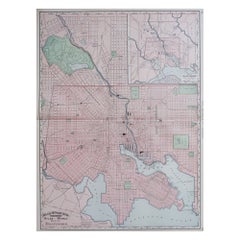
Large Original Antique City Plan of Baltimore, USA, 1894
By Rand McNally
Co.
Located in St Annes, Lancashire
Fabulous colorful map of Baltimore
Original color
By Rand, McNally & Co.
Published, 1894
Unframed
Free shipping.
Category
Antique 1890s American Maps
Materials
Paper
$90
Free Shipping
H 26.75 in W 20.5 in D 0.07 in
Large Original Antique City Plan of Philadelphia, USA, circa 1900
By Rand McNally
Co.
Located in St Annes, Lancashire
Fabulous colorful map of Philadelphia
Original color
By Rand, McNally & Co.
Published, circa 1900.
Unframed
Free shipping.
Category
Antique Early 1900s American Maps
Materials
Paper

$90
Free Shipping
H 20.5 in W 27.5 in D 0.07 in
Large Original Antique City Plan of Montreal, Canada, circa 1900
By Rand McNally
Co.
Located in St Annes, Lancashire
Fabulous colorful map of Montreal
Original color
By Rand, McNally & Co.
Published, circa 1900
Unframed
Minor edge tears
Free shipping.
Category
Antique Early 1900s American Maps
Materials
Paper

$90
Free Shipping
H 20.5 in W 27.5 in D 0.07 in
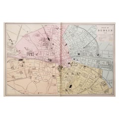
Large Original Antique City Plan of Dublin, Ireland, circa 1880
Located in St Annes, Lancashire
Great city plan of Dublin
Published circa 1880
Unframed
Free shipping.
.
Category
Antique 1880s Scottish Maps
Materials
Paper
$90
Free Shipping
H 13.5 in W 20 in D 0.07 in
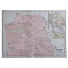
Large Original Antique City Plan of San Francisco, USA, 1894
By Rand McNally
Co.
Located in St Annes, Lancashire
Fabulous colorful map of San Francisco
Original color
By Rand, McNally & Co.
Published, 1894
Unframed
Free shipping.
Category
Antique 1890s American Maps
Materials
Paper
$90
Free Shipping
H 20.5 in W 26.75 in D 0.07 in
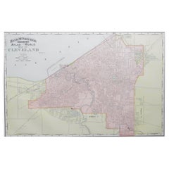
Original Antique City Plan of Cleveland, Ohio, USA, circa 1900
By Rand McNally
Co.
Located in St Annes, Lancashire
Fabulous colorful map of Cleveland
Original color
By Rand, McNally & Co.
Published, circa 1900
Unframed
Free shipping.
Category
Antique 1890s American Maps
Materials
Paper
$90
Free Shipping
H 14 in W 20.5 in D 0.07 in
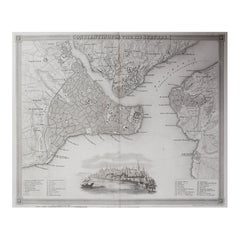
Original Antique Map or City Plan of Istanbul, Turkey. Circa 1835
Located in St Annes, Lancashire
Nice map of Istanbul
Drawn and engraved by J.Dower
Published by Orr & Smith. C.1835
Unframed.
Free shipping
Category
Antique 1830s English Maps
Materials
Paper
$60
Free Shipping
H 9.25 in W 12.25 in D 0.07 in
Original Antique Map or City Plan of Venice, Italy. Circa 1835
Located in St Annes, Lancashire
Nice map of Venice
Drawn and engraved by J.Dower
Published by Orr & Smith. C.1835
Unframed.
Free shipping
Category
Antique 1830s English Maps
Materials
Paper

$60
Free Shipping
H 9.25 in W 12.25 in D 0.07 in
More From This Seller
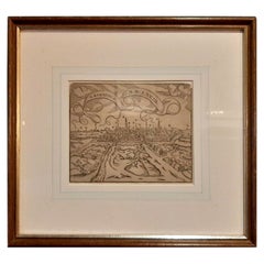
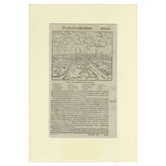
View AllAntique Print of the City of Rome, Italy by Münster, C.1580
Located in Langweer, NL
Antique print titled 'Abbildung der Statt Rom/wie sie von Romulo anfänge - Von Italia'. Woodcut of ancient Rome. This print originates from Munster's Cosmographia, one of the most in...
Category
Antique 16th Century German Prints
Materials
Paper
Old Antique Print of the City of Groningen, The Netherlands, by Münster, c.1600
By Sebastian Münster
Located in Langweer, NL
Antique print titled 'Groeninga'. View of the city of Groningen, the Netherlands. This map originates from 'Cosmographia' published by Münster.
Artists and Engravers: Sebastian Münster...
Category
Antique 16th Century Prints
Materials
Paper
$322 Sale Price
20% Off
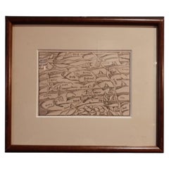
Antique Map of Brabant and part of Belgium by Munster, c.1580
Located in Langweer, NL
Antique map titled 'Braband'. Original woodcut print of the region of Brabant (the Netherlands) and part of Belgium. Charming miniature originating from 'Cosmographia' by S. Munster....
Category
Antique 16th Century Maps
Materials
Paper
Antique Print of the City of Groningen, The Netherlands, by Münster, c.1600
By Sebastian Münster
Located in Langweer, NL
Antique print titled 'Groeninga'. View of the city of Groningen, the Netherlands. This map originates from 'Cosmographia' published by Münster.
Artists and Engravers: Sebastian Münster...
Category
Antique 16th Century Prints
Materials
Paper
$256 Sale Price
20% Off
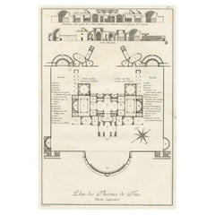
Antique Plan of the Overground Area of Baths of Emperor Titus, Rome, Italy, 1786
Located in Langweer, NL
Antique print titled 'Plan des Thermes de Titus Partie Superieure'.
Plan of the overground area of the Baths of Titus. The Baths of Titus or Thermae Titi were public baths (Thermae) built in 81 AD at Rome, by Roman emperor Titus...
Category
Antique 18th Century Prints
Materials
Paper
$265 Sale Price
20% Off
Antique Map of Denmark by Münster
1588
Located in Langweer, NL
Antique map titled 'Beschreibung des Königreichs Dennmarck (..)'. Early map of Denmark. This map originates from 'Cosmographey Oder beschreibung Aller Länder (..)' by Sebastian Münster.
Category
Antique 16th Century Maps
Materials
Paper
Still Thinking About These?
All Recently ViewedMore Ways To Browse
Gibraltar Antique Map
Guyana Antique Map
Maps Of New Mexico
Saudi Arabia Map
16th Century Scotland
Antique Leather Map
Antique Map Of Argentina
Antique Map Of Colombia
Cornwall Map
Early Texas Furniture
Iraq Map
James Cook Map
Kentucky Antiques
Map Of Mexican California
Montreal Map
Mughal Map
Napoleon Map
Rand Mcnally Vintage Maps