Want more images or videos?
Request additional images or videos from the seller
1 of 5
Auction endedBrowse Current Auctions
Original Antique Plan of The Siege of Toulon, Napoleon Bonaparte. Circa 1850
Price:$30
$115List Price
About the Item
About the Seller
4.9
Platinum Seller
Premium sellers with a 4.7+ rating and 24-hour response times
1stDibs seller since 2016
3,260 sales on 1stDibs
Typical response time: 1 hour
Associations
International Confederation of Art and Antique Dealers
Associations
Authenticity Guarantee
In the unlikely event there’s an issue with an item’s authenticity, contact us within 1 year for a full refund. DetailsMoney-Back Guarantee
If your item is not as described, is damaged in transit, or does not arrive, contact us within 7 days for a full refund. Details24-Hour Cancellation
You have a 24-hour grace period in which to reconsider your purchase, with no questions asked.Vetted Professional Sellers
Our world-class sellers must adhere to strict standards for service and quality, maintaining the integrity of our listings.Price-Match Guarantee
If you find that a seller listed the same item for a lower price elsewhere, we’ll match it.Trusted Global Delivery
Our best-in-class carrier network provides specialized shipping options worldwide, including custom delivery.You May Also Like
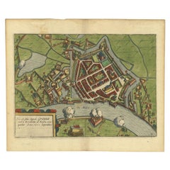
Antique Plan of the Siege of Grave by Guicciardini, c.1608
Located in Langweer, NL
Antique map titled 'Hic est situs oppidi Grauiae (..)'. Bird's eye view plan of Grave, The Netherlands, Holland. Showing the siege of Grave in the year 1602. Source unknown, to be de...
Category
Antique 17th Century Maps
Materials
Paper
Antique Plan of Grave, The Netherlands, Showing the Siege of Grave in 1602
Located in Langweer, NL
Antique map titled 'Die Stat Grave' Bird's eye view plan of Grave, The Netherlands, Holland. Showing the siege of Grave in the year 1602 by Prince Maurits of The Netherlands. Source ...
Category
Antique 16th Century Maps
Materials
Paper
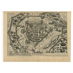
$527
H 9.73 in W 13 in D 0 in
Pipe with the head of Napoleon Bonaparte as pipe head
Located in
S-HERTOGENBOSCH, NL
A pipe with a detailed head of Napoleon Bonaparte as pipe head,
in ebonished wood.
Category
Antique 1880s French Napoleon III Tobacco Accessories
Materials
Horn, Wood

Original Antique Print of a Rabbi, Published circa 1850
Located in Langweer, NL
Description: Antique print titled 'Der Rabbiner - The Rabbi'. Original antique print of a rabbi. Published circa 1850.
Artists and Engravers: Engraved by W. French after a painti...
Category
Antique Mid-19th Century Prints
Materials
Paper

4 Volumes. Sloane, William M. Life Of Napoleon Bonaparte.
Located in New York, NY
4 Volumes. Sloane, William M. Life Of Napoleon Bonaparte. Bound in 3/4 red morocco, cloth boards, top edges gilt, raised bands, gilt panels, marbled endpapers, colored frontispieces ...
Category
Early 20th Century American Books
Materials
Leather

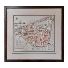
Antique City Plan of Rotterdam in Frame, ca.1850
Located in Langweer, NL
Antique map titled 'Grondkaart der stad Rotterdam (..)'. Original antique city plan of Rotterdam, the Netherlands. Published circa 1850.
Artists...
Category
Antique 19th Century Prints
Materials
Paper
Antique Map of The Siege of Gennep, the Netherlands, c.1650
Located in Langweer, NL
Antique map titled 'Belagerung des Besten Schloss und Passes Gennep'. Old map of the Siege of Gennep, the Netherlands. This map originates from 'Theatrum Europaeum' by M. Merian. Art...
Category
Antique 17th Century Maps
Materials
Paper

Japanese Export Nagasaki Lacquer Box with the Portrait of Napoleon Bonaparte
Located in Amsterdam, NL
A Japanese export Nagasaki lacquer tobacco box with the portrait of Napoleon Bonaparte
Edo-period, circa 1810
The box in black lacquer on copper, ...
Category
Antique 19th Century Japanese Edo Lacquer
Materials
Copper, Gold
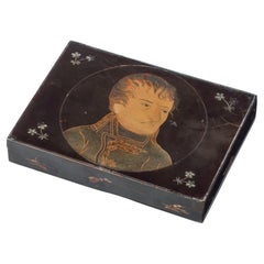
$11,399
Free Shipping
H 0.95 in W 5.99 in D 4.45 in
Antique Plan of Turkey in Europe with Inset Map of the Bosporus, ca.1850
Located in Langweer, NL
Antique map titled 'Turkey in Europe'.
A map of European Turkey and the surrounding countries. With an inset map of the Bosporus. This includes Macedonia, Bulgaria, Croatia, Bosn...
Category
Antique 1850s Maps
Materials
Paper
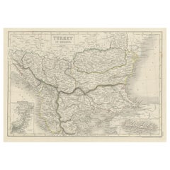
$263
H 11.82 in W 17.33 in D 0 in
Sloane, the Life of Napoleon Bonaparte, New Revised Edition, in a Fine Binding
Located in Hillsborough, NJ
AUTHOR: SLOANE, William Milligan.
TITLE: The Life Of Napoleon Bonaparte.
PUBLISHER: London: The Times Book Club, 1912.
DESCRIPTION: NEW REVISED AND ENLARGED EDITION. 4 vols., 8" ...
Category
Vintage 1910s British Books
Materials
Leather

$1,500 / set
H 8 in W 5.5 in D 2 in
More From This Seller
View AllLarge Original Antique City Plan of Philadelphia, USA, circa 1900
By Rand McNally
Co.
Located in St Annes, Lancashire
Fabulous colorful map of Philadelphia
Original color
By Rand, McNally & Co.
Published, circa 1900.
Unframed
Free shipping.
Category
Antique Early 1900s American Maps
Materials
Paper

Large Original Antique City Plan of Montreal, Canada, circa 1900
By Rand McNally
Co.
Located in St Annes, Lancashire
Fabulous colorful map of Montreal
Original color
By Rand, McNally & Co.
Published, circa 1900
Unframed
Minor edge tears
Free shipping.
Category
Antique Early 1900s American Maps
Materials
Paper

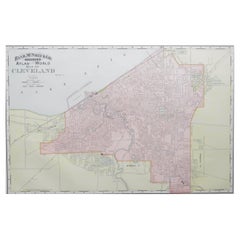
Original Antique City Plan of Cleveland, Ohio, USA, circa 1900
By Rand McNally
Co.
Located in St Annes, Lancashire
Fabulous colorful map of Cleveland
Original color
By Rand, McNally & Co.
Published, circa 1900
Unframed
Free shipping.
Category
Antique 1890s American Maps
Materials
Paper
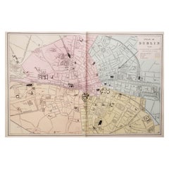
Large Original Antique City Plan of Dublin, Ireland, circa 1880
Located in St Annes, Lancashire
Great city plan of Dublin
Published circa 1880
Unframed
Free shipping.
.
Category
Antique 1880s Scottish Maps
Materials
Paper
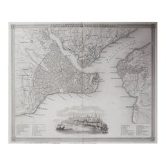
Original Antique Map or City Plan of Istanbul, Turkey. Circa 1835
Located in St Annes, Lancashire
Nice map of Istanbul
Drawn and engraved by J.Dower
Published by Orr & Smith. C.1835
Unframed.
Free shipping
Category
Antique 1830s English Maps
Materials
Paper
Original Antique Map or City Plan of Venice, Italy. Circa 1835
Located in St Annes, Lancashire
Nice map of Venice
Drawn and engraved by J.Dower
Published by Orr & Smith. C.1835
Unframed.
Free shipping
Category
Antique 1830s English Maps
Materials
Paper
