Items Similar to Original Old Map East of Stockholm, the Island Ljusterö and Värmdö, Sweden, 1720


Want more images or videos?
Request additional images or videos from the seller
1 of 5
Original Old Map East of Stockholm, the Island Ljusterö and Värmdö, Sweden, 1720
$1,381.15
£1,023.07
€1,150
CA$1,889.76
A$2,056.20
CHF 1,088.73
MX$24,737.48
NOK 13,824.47
SEK 12,648.42
DKK 8,763.94
About the Item
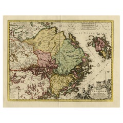
Antique map titled 'Accurate Carte der Upländischen Scheren mit der Situation und Gegend umb die Konigle Schwedisch Haupt und Residentz Stadt Stockholm.'
Map of the area east of Stockholm, embracing the area to the island Ljusterö on the north and Värmdö. with two panoramic views of Stockholm below. The views are uncolored as issued. Large decorative title cartouche.
Source unknown, to be determined.
Artists and Engravers: Made by 'Homann Heirs' after an anonymous artist. Made by an anonymous engraver after 'Homann Heirs'. Following the long period of Dutch domination, the Homann family became the most important map publishers in Germany in the eighteenth century, the business being founded by J.B. Homann in Nuremberg about the year 1702. Soon after publishing his first atlas in 1707 he became a member of the Berlin academy of Sciences and in 1715 he was appointed Geographer to the Emperor. After the founder's death in 1724, the firm was continued under the direction of his son until 1730 and was then bequeathed to his heirs on the condition that it trades under the name of Homann Heirs. The firm remained in being until the next century and had a wide influence on map publishing in Germany. Apart from the atlases the firm published a very large number of individual maps. The Homanns produced a Neuer Atlas in 1714, a Grosser Atlas in 1737, and an Atlas Maior with about 300 maps in 1780. They also issued a special Atlas of Germany with full sized plans of principal cities, school atlases and an Atlas of Silesia in 1750 with 20 maps.
Condition:
Good, given age. Paper separation bottom middle fold; repaired. Small tear bottom edge, not affecting image. Light staining and soiling in the margins. A few small spots. Original middle fold as issued. General age-related toning and/or occasional minor defects from handling. Please study image carefully.
- Dimensions:Height: 21.11 in (53.6 cm)Width: 24.89 in (63.2 cm)Depth: 0 in (0.02 mm)
- Materials and Techniques:
- Period:1720-1729
- Date of Manufacture:1720
- Condition:
- Seller Location:Langweer, NL
- Reference Number:Seller: PCT-598531stDibs: LU3054326680422
About the Seller
5.0
Recognized Seller
These prestigious sellers are industry leaders and represent the highest echelon for item quality and design.
Platinum Seller
Premium sellers with a 4.7+ rating and 24-hour response times
Established in 2009
1stDibs seller since 2017
2,816 sales on 1stDibs
Typical response time: 1 hour
- ShippingRetrieving quote...Shipping from: Langweer, Netherlands
- Return Policy
More From This Seller
View AllMap of Denmark Divided into Dioceses – G.
L. Valk, ca. 1690
Located in Langweer, NL
Map of Denmark Divided into Dioceses – G. & L. Valk, ca. 1700
Detailed antique map titled "Regnum Daniae, divisum in Dioeceses Arhusiam, Albergum, Viborgum, et Ripam," showing Denma...
Category
Antique Late 17th Century Maps
Materials
Paper

$528 Sale Price
20% Off
Original and Decorative Antique Engraved Map of Finland and Sweden, ca.1720
Located in Langweer, NL
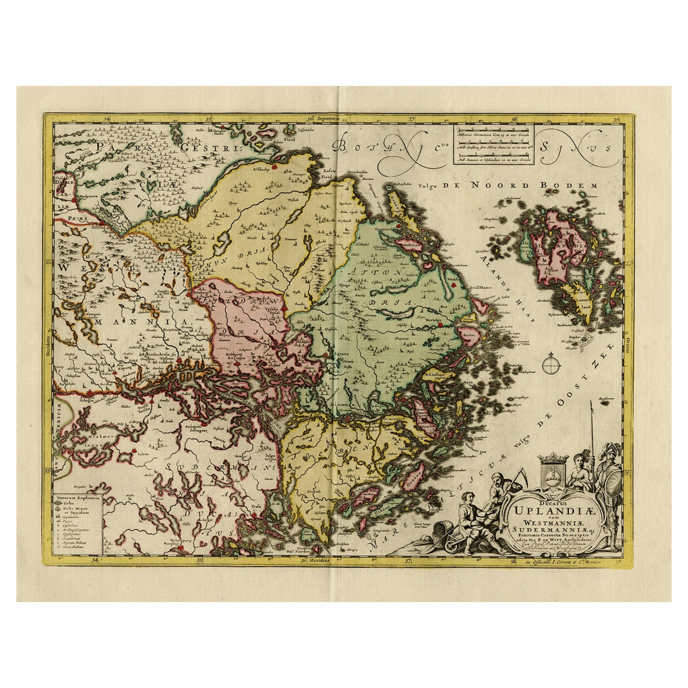
Antique map titled 'Ducatus Uplandiae cum Westmanniae Sudermanniae (..)'
This map shows parts of Finland and Sweden. Originally published by Frederick de Wit in the late 1600's. ...
Category
Antique 1720s Maps
Materials
Paper
$1,393 Sale Price
20% Off
Antique Map of Denmark with Details of Fortresses, Cities, Towns Etc, c.1680
Located in Langweer, NL
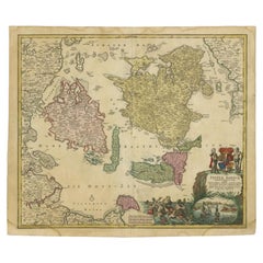
Antique map of Denmark titled 'Insularum Danicarum ut Zee-Landiae, Fioniae, Langelandiae, Lalandiae Falstriae, Fembriae, Monae (..)'. This map depicts the main Danish Islands and a s...
Category
Antique 17th Century Maps
Materials
Paper

Antique Map of Scandinavia by Van der Aa
circa 1710
Located in Langweer, NL
Antique map titled 'Scandinavie Septentrionale' and 'Scandinavie Meridionale'. Copper engraving with two maps on one sheet. The upper map depicts Northern Scandinavia with Norway, Sw...
Category
Antique Early 18th Century Dutch Maps
Materials
Paper

Southern Sweden Provinces Map – Homann’s ‘Nova Tabula Scaniae’, ca. 1730
Located in Langweer, NL
Southern Sweden Provinces Map – Homann’s ‘Nova Tabula Scaniae’, ca. 1730
Antique map titled 'Nova Tabula Scaniae in qua sunt Scania, Blekingia et Hallandia'. This decorative map sho...
Category
Antique Mid-18th Century German Maps
Materials
Paper

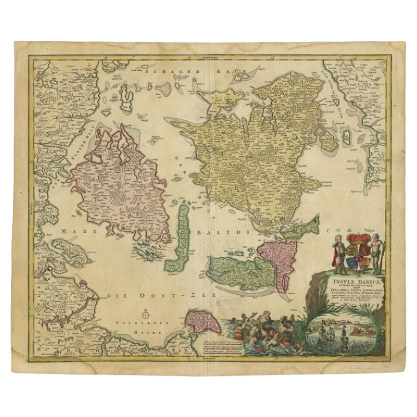
Antique Map of the Islands of Denmark by Homann Heirs, 1720
Located in Langweer, NL
Antique map titled 'Insula Danicae in Mari Balthico sitae (..).' - Map of the Danish islands situated in the Baltic Sea by J. B. Homann, (after J. Hübner's map of the region ) with g...
Category
Antique 18th Century Maps
Materials
Paper
You May Also Like
1646 Jansson Map Entitled "Procinvia Connactiae, " Ric.a006
Located in Norton, MA
1646 Jansson map entitled
"Procinvia connactiae,"
Ric.a006
Description: The PROVINCE of CONNAVGT 490 x 380From vol 4 of Jansson's Atlas Novus 1646, published in Amsterdam with...
Category
Antique 17th Century Unknown Maps
Materials
Paper

Hand-Colored 18th Century Homann Map of Denmark and Islands in the Baltic Sea
By Johann Baptist Homann
Located in Alamo, CA
An 18th century copper plate hand-colored map entitled "Insulae Danicae in Mari Balthico Sitae utpote Zeelandia, Fionia, Langelandia, Lalandia, Falstria, Fembria Mona" created by Joh...
Category
Antique Early 18th Century German Maps
Materials
Paper

$620 Sale Price
20% Off
17th Century Map of Denmark by French Cartographer Sanson, Dated 1658
By Nicolas Sanson
Located in Copenhagen, K
17th century map of Denmark by French cartographer Sanson.
Nicolas Sanson (20 December 1600-7 July 1667) was a French cartographer, termed by some the creator of French geography an...
Category
Antique 17th Century French Maps
Materials
Paper

Original Antique Map of Sweden, Engraved by Barlow, 1806
Located in St Annes, Lancashire
Great map of Sweden
Copper-plate engraving by Barlow
Published by Brightly & Kinnersly, Bungay, Suffolk. 1806
Unframed.
Category
Antique Early 1800s English Maps
Materials
Paper

1633 Map "La Souverainete De Sedan Et De Raucourt, Et La Prevoste Ric0011
Located in Norton, MA
1653 map entitled
"La Souverainete de Sedan et de Raucourt, et la Prevoste de Doncheri,"
Ric0011
Description:
Lovely map centered on Sedan and Doncheri and the Meuze River fr...
Category
Antique 17th Century Dutch Maps
Materials
Paper

1718 Ides
Witsen Map "Route D
amsterdam a Moscow Et De La Ispahan Et Gamron
Located in Norton, MA
1718 Ides & Witsen map, entitled
"Route D'Amsterdam A Moscow Et De La Ispahan Et Gamron,"
Ric.b005
Subject: Eastern Europe and Central Asia
Period: 1718 (published)
Publicati...
Category
Antique Early 18th Century Dutch Maps
Materials
Paper

More Ways To Browse
Antique Maps Of Russian Empire
J C Walker Map
Massachusetts Antiques
Persian Maps
Afghanistan Antique Map
Antique Furniture Delaware
Antique Furniture Wisconsin
Antique Map By Coronelli
Antique Map Iceland
Cyprus Antique Maps
John Speed Maps
M Howard
Used Office Furniture Michigan
Antique Geological Maps
Antique Manitoba
Australian Colonial
Bengal Map
Stanford Furniture